Washington State Route 505
| ||||
|---|---|---|---|---|
|
Map of southwestern Washington with SR 505 highlighted in red | ||||
| Route information | ||||
| Auxiliary route of [[Interstate 5 (Washington) |]] | ||||
| Defined by RCW 47.17.660 | ||||
| Maintained by WSDOT | ||||
| Length: | 19.29 mi[1] (31.04 km) | |||
| Existed: | 1992 (Original route 1964) – present | |||
| Major junctions | ||||
| West end: | Kerron Street in Winlock | |||
|
| ||||
| East end: |
| |||
| Location | ||||
| Counties: | Lewis, Cowlitz | |||
| Highway system | ||||
| ||||

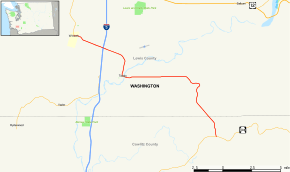
State Route 505, abbreviated SR 505, is a small state highway in the U.S. state of Washington that connects the town of Winlock and State Route 504. It starts at its western terminus at Kerron Street, and ends at its eastern terminus at State Route 504.
Route description
SR 505 starts at the intersection of Kerron Street and Walnut Street in Winlock. It continues east to Interstate 5, then follows Toledo-Winlock Road into the town of Toledo. It winds through Toledo on 5th Street and Kellog Way until heading east on Cowlitz Street to State Route 504.
History
Until 1992, SR 505 from I-5 west to Winlock was part of State Route 603, which continued north from Winlock through Napavine to SR 6 about two miles (3 km) west of I-5 in Chehalis. Several changes were made to the state highways throughout Washington in 1992, and at that time the section from SR 6 to Winlock was turned back to the county, while the rest became a part of a realignment of SR 505. The county road is still signed "Highway 603" from SR 6 to Winlock even though it is no longer part of the state highway system.
Major intersections
| County | Location | mi | km | Destinations | Notes |
|---|---|---|---|---|---|
| Lewis | Winlock | 0.00 | 0.00 | Kerron Street | Western terminus |
| | 2.96 | 4.76 | |||
| Cowlitz | | 19.21 | 30.92 | Eastern terminus | |
| 1.000 mi = 1.609 km; 1.000 km = 0.621 mi | |||||
Related routes
References
- ↑ Washington State Department of Transportation. "State Highway Log, 2006" (PDF). Retrieved April 22, 2007.