Washington State Route 531
| ||||
|---|---|---|---|---|
|
SR 531 highlighted in red | ||||
| Route information | ||||
| Auxiliary route of I‑5 | ||||
| Defined by RCW 47.17.757 | ||||
| Maintained by WSDOT | ||||
| Length: | 9.88 mi[1] (15.90 km) | |||
| Existed: | 1991[2] – present | |||
| Major junctions | ||||
| West end: |
| |||
|
| ||||
| East end: |
| |||
| Highway system | ||||
| ||||

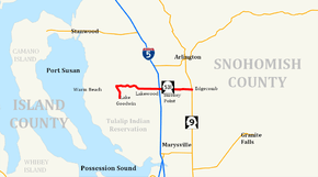
State Route 531 (SR 531) is a short Washington state highway in Snohomish County. It extends east 9.88 miles (15.90 km), from Wenberg County Park in the community of Lake Goodwin, to SR 9 in southeast Arlington. SR 531 intersects Interstate 5 (I-5), and passes the Arlington Airport. The route connects I-5 to SR 9, Smokey Point, and Wenberg County Park. The Washington State Legislature approved SR 531's current route in 1991. Since then, construction projects, arranged by the Washington State Department of Transportation (WSDOT), have turned this small road into an arterial street. Even though the Washington State Legislature and WSDOT approved SR 531 in 1991, they erected no signs until April 1, 1992, when the law creating the road took effect.
The road now used by SR 531 has existed as a separate route since at least 1911. A map dating from 1911 shows that 172nd Street, then known simply as Lakewood Road and Edgecomb Road, extended east from its current intersection with SR 9 to the banks of the South Fork Stillaguamish River.
Route description

State Route 531 runs about 9.88 miles (15.90 km), from Wenberg County Park to State Route 9 south of Arlington.[3] The route links the communities of Lake Goodwin, North Lakewood (also known as Lakewood), Smokey Point, and Edgecomb. It also passes four schools in the Lakewood School District,[4][5][6] as well as Weston High School in the Arlington School District.[7] The road intersects four major arteries: Forty-Five Road, Interstate 5, Smokey Point Boulevard (formerly known as U.S. Route 99), and 67th Avenue, before ending at SR 9.[8][9] WSDOT found that, based on average annual daily traffic (AADT) data, about 35,000 motorists utilize the road daily at the I-5 interchange.[10]
Starting at Wenberg County Park, the route runs north along East Lake Goodwin Road until it intersects Lakewood Road. From there, SR 531 travels east along Lakewood Road around Lake Ki before reaching Forty-Five Road. Here, Lakewood Road becomes the main artery of North Lakewood and Smokey Point, 172nd Street. Continuing east, SR 531 intersects 11th Avenue.[8]
After intersecting 11th Avenue, SR 531 becomes the northern boundary of the Lakewood High School campus. SR 531 continues east from 11th Avenue to 16th Drive,[11] shortly after entering Marysville city limits.[12] Soon thereafter, the road intersects 19th Drive, which connects the southeastern section of North Lakewood with SR 531. Continuing east across a double track, the highway intersects 27th Avenue, which connects the road with Lakewood Crossing, a shopping center in Lakewood. SR 531 then continues further east to the interchange with I-5.[8][13]
After leaving the interchange with I-5, along with North Lakewood and Marysville city limits,[12][14] SR 531 continues east to Smokey Point Boulevard (formerly U.S. Route 99) in Smokey Point. The road then maintains straight east,[15] passing Weston High School and Arlington Municipal Airport before intersecting 67th Avenue. From 67th Avenue, SR 531 travels east to a suburban community of Edgecomb.[16] The road curves northeast and then southeast while on a hill. SR 531 travels east past the Arlington Gun Range and Gleneagle, a large housing area, before ending at an intersection with SR 9.[8][17]
History
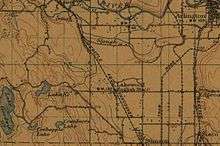
The whole stretch highway from Wenberg County Park to current SR 9 has been known to exist earlier than 1911.[18] 172nd Street NE, now SR 531, once extended from what is currently SR 9 to the banks of the South Fork Stillaguamish River.[18] This part of the highway has been removed.[8]
SR 531 became a state highway in 1991, but the highway designation did not take effect until April 1, 1992.[19] In 2006, WSDOT announced it would complete three more projects over about five years to improve SR 531. The first, to improve the bridge and interchange between I-5 and SR 531, began immediately.[20] The Tulalip, Stillaguamish, Samish and Kikiallus Tribes helped fund the construction of the project.[20] On April 30, 2005, the old two-lane SR 531 bridge was demolished during the night.[21] WSDOT redirected traffic on SR 531 to the completed north side of the new bridge,[22] while the northbound lanes of Interstate 5 were closed to all traffic and rerouted on ramps from I-5 to SR 531.[22][23] During construction, eastbound SR 531 left-turn lanes were closed; a detour on Smokey Point Boulevard and SR 530 provided direct drivers access to northbound I-5.[24] The other half of the bridge was later demolished in May 2005.[25] All of the temporary structures on the bridge were subsequently removed in December 2005.[26] Partly finished in June 2006, WSDOT plans to complete the project after adding a loop ramp in 2011.[27] In August 2007, WSDOT completed a project to add sidewalks along SR 531 to the adjacent schools of the Lakewood School District.[28]
An upcoming project, adding a loop ramp onto the I-5 interchange, started in March 2009 and will end in 2011.[27][29] WSDOT has awarded the contract for the project to Northwest Construction, Inc.[30] Part of the project includes widening the main entry point to Lakewood Crossing, by adding turn pockets.[31] Widening SR 531 between 43rd Avenue NE and 67th Avenue NE from its current two to five lanes near the Arlington Airport is another planned project.[32][33] The project is currently in planning stages and WSDOT has set up a webpage for the project.[34]
Major intersections
The entire highway is in Snohomish County.
| Location | mi[1] | km | Destinations | Notes | |
|---|---|---|---|---|---|
| Wenberg County Park | 0.00 | 0.00 | |||
| Arlington | 6.36 | 10.24 | |||
| 6.63 | 10.67 | Smokey Point Boulevard | Formerly US 99 | ||
| 9.88 | 15.90 | ||||
| 1.000 mi = 1.609 km; 1.000 km = 0.621 mi | |||||
References
- 1 2 Washington State Department of Transportation. "State Highway Log, 2006" (PDF). Retrieved April 22, 2007.
- ↑ Washington State Legislature. "RCW 47.26.167". Retrieved July 11, 2008.
- ↑ Snohomish County Road Map (Map). Puget Sound Maps: Washington State, Snohomish County, Seattle, Whidbey Island & McKinnon's Real Estate Service Area. McKinnon's Real Estate. November 7, 2006. Retrieved October 17, 2008.
- ↑ Lakewood School District Campus Site Plan (PDF) (Map). Lakewood School District. Retrieved October 26, 2008.
- ↑ Lakewood School District Boundaries (PDF) (Map). Cartography by Thomas Brothers. Lakewood School District. 1995. Retrieved October 26, 2008.
- ↑ Lakewood School District Elementary Boundaries (Map). Cartography by Thomas Brothers. Lakewood School District. 1995. Retrieved October 26, 2008.
- ↑ DeLorme Washington Atlas & Gazetteer (Map) (5th ed.). 1:160,000. DeLorme Atlas & Gazetteer. Rand McNally, DeLorme. 2008. p. 95. Retrieved October 26, 2008.
- 1 2 3 4 5 Google (December 20, 2015). "State Route 531" (Map). Google Maps. Google. Retrieved December 20, 2015.
- ↑ Marysville Fire Districts (PDF) (Map). City of Marysville. Retrieved November 2, 2008.
- ↑ Washington State Department of Transportation (2007). "Washington Annual Average Daily Traffic Data" (PDF). Retrieved August 26, 2008.
- ↑ SR 531 – Lakewood Schools Sidewalks – Project Map (Map). Cartography by Tele Atlas. Washington State Department of Transportation. 2005. Retrieved October 17, 2008.
- 1 2 City of Marysville (PDF) (Map). City of Marysville. October 2007. Retrieved November 2, 2008.
- ↑ Smokey Point: I-5/172nd Street NE (SR 531) Interchange Modifications Map (Map). Washington State Department of Transportation. Retrieved October 17, 2008.
- ↑ I-5 – 172nd St Street (SR 531, Smokey Point) Interchange Improvements – Project Map (Map). Washington State Department of Transportation. Retrieved October 17, 2008.
- ↑ City of Marysville, Topography (PDF) (Map). City of Marysville. 2005. Retrieved November 2, 2008.
- ↑ GM Johnson (2004). Marysville, Arington, Stanwood, Camano Island (Map) (2004 ed.). City Street Maps. Burnaby, British Columbia: GM Johnson. ISBN 1-897152-67-1. Retrieved July 7, 2008.
- ↑ Official State Highway Map (PDF) (Map) (2008-2009 ed.). 1:842,000. Official State Highway Maps. Cartography by U.S. Geological Survey. Olympia, Washington: Washington State Department of Transportation. 2008. § 3C. Retrieved July 23, 2008.
- 1 2 Topography map of Mount Vernon and Vincity (Map) (January 1911 ed.). 1:125,000. United States Geological Survey. 1911. Retrieved September 12, 2008.
- ↑ Washington State Legislature. "RCW 47.17.757". Retrieved May 9, 2008.
- 1 2 Washington State Department of Transportation. "I-5/SR 531 Interchange Improvements". Archived from the original on December 30, 2006. Retrieved May 10, 2008.
- ↑ Washington State Department of Transportation. "Construction Photos – Smokey Point: I-5/172nd St. NE (SR 531) Interchange Modifications". Archived from the original on October 4, 2006. Retrieved November 21, 2008.
- 1 2 Washington State Department of Transportation. "I-5 – Smokey Point: 172nd St. NE Construction Progress". Archived from the original on October 4, 2006. Retrieved November 21, 2008.
- ↑ Phillips, Greg (April 28, 2005). "Big Construction Weekend on I-5 from Arlington to the Pierce County Line – I-5 Smokey Point bridge replacement, 172nd Street NE (SR 531), Arlington". Washington State Department of Transportation. Archived from the original on October 1, 2006. Retrieved November 22, 2008.
- ↑ I-5 – Smokey Point Project – Detour (Map). Cartography by Tele Atlas. Washington State Department of Transportation. Retrieved November 21, 2008.
- ↑ Ahmadi, Amir; Michell Mouton (May 2, 2005). "WSDOT Successfully Demolishes Half of Arlington's Smokey Point Bridge – Second Half Slated for Demolition Next Weekend". Washington State Department of Transportation. Archived from the original on October 1, 2006. Retrieved November 22, 2008.
- ↑ Ahmadi, Amir; Travis Phelps (December 14, 2005). "Nighttime Closures of Northbound I-5 This Week in Arlington". Washington State Department of Transportation. Archived from the original on October 1, 2006. Retrieved November 22, 2008.
- 1 2 Washington State Department of Transportation. "I-5/SR 531 Loop Ramp". Retrieved May 10, 2008.
- ↑ Washington State Department of Transportation. "SR 531 Lakewood Schools Sidewalks". Retrieved May 10, 2008.
- ↑ Fiege, Gale (January 19, 2009). "Smokey Point to get new I-5 ramps". The Everett Herald. Retrieved January 20, 2009.
- ↑ Amir Ahmadi; Jones, Aurora (January 13, 2009). "WSDOT awards project to improve I-5 interchange near Arlington". Washington State Department of Transportation. Retrieved January 31, 2009.
- ↑ Sheets, Bill (April 21, 2009). "I-5 due for lots of work this year". The Everett Herald. Retrieved May 10, 2009.
- ↑ Washington State Department of Transportation. "SR 531 Widening Project- 43rd Avenue to 67th Avenue" (PDF). Retrieved July 7, 2008.
- ↑ "RTID transportation, transit improvement goes to Marysville voters Nov. 6" (PDF). Marysville Messenger. City of Marysville. Fall 2007. p. 6. Retrieved July 15, 2008.
- ↑ Washington State Department of Transportation. "SR 531 - Arlington Corridor - Pre-Design Analysis". Retrieved May 10, 2009.
External links
| Wikimedia Commons has media related to Washington State Route 531. |
- Washington State Department of Transportation: 2006 overpass widening
- Washington State Department of Transportation: 2009 overpass work
- Traffic camera for SR 531 – I-5 interchange (WSDOT)
- Underneath SR 531's Cougar Creek Bridge on YouTube from WSDOT