Washington State Route 528
| ||||
|---|---|---|---|---|
|
Fourth Street 64th Street | ||||
|
SR 528 highlighted in red. | ||||
| Route information | ||||
| Auxiliary route of I‑5 | ||||
| Defined by RCW 47.17.750 | ||||
| Maintained by WSDOT | ||||
| Length: | 3.46 mi[1] (5.57 km) | |||
| Existed: | 1964[2] – present | |||
| Major junctions | ||||
| West end: |
| |||
|
| ||||
| East end: |
| |||
| Highway system | ||||
| ||||

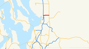
State Route 528 (SR 528) is a state highway located entirely in the city of Marysville within Snohomish County, Washington. It extends 3.46 miles (5.57 km) from an interchange with Interstate 5 (I-5) through Downtown Marysville, east to SR 9. The route serves as a connector to Downtown Marysville. The highway was part of the Marysville branch of Primary State Highway 1 (PSH 1 MA) from 1937 until 1964. In 1964, PSH 1 MA became SR 528.
Route description
State Route 528 (SR 528) runs 3.46 miles (5.57 km) from an interchange with Interstate 5 (I-5) east to SR 9, entirely in Marysville.[3][4] The route serves as a connector to Downtown Marysville.[3] WSDOT has found that more than 35,000 motorists utilize the road daily after the I-5 interchange based on average annual daily traffic (AADT) data.[5]
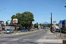
Starting at I-5 exit 199 on the Marysville–Tulalip Indian Reservation boundary,[6] the highway, which continues northwest as Marine Drive towards Stanwood,[4] becomes Fourth Street.[1] After the interchange with I-5, SR 528 intersects Beach Avenue and Cedar Avenue before crossing two railroad tracks that are owned by the Burlington Northern Santa Fe Railway.[7][8] The railroad goes south to Seattle and north to Vancouver, BC.[9] Immediately after the railroad crossing, the road starts forming the northern boundary of the Marysville Mall and intersects Delta Avenue before intersecting State Avenue, known as SR 529 and the former route of U.S. Route 99 (US 99).[3][10]
Then, the highway intersects 47th Avenue, also known as Armar Road,[1][11] before going northwest to cross Allen Creek;[12] SR 528 forms the southern boundary of Jennings Memorial Park at this point.[13] The highway becomes 64th Street and goes due east for the rest of its route.[11] SR 528 intersects 60th Drive, which serves as a connector to the Marysville YMCA;[14][15] the road also serves Allen Creek Elementary,[16] which is part of the Marysville School District.[17] The road then intersects 67th Avenue, a major road traveling north towards Arlington.[4] After the intersection, SR 528 crosses Munson Creek and passes Foothills Park before ending at an intersection with SR 9.[3][11]
History

When the Primary and Secondary Highways were created in 1937, the route of SR 528 became the Marysville branch of Primary State Highway 1 (PSH 1 MA).[18] PSH 1 MA ran from PSH 1 in Marysville to Secondary State Highway 1A (SSH 1A).[18] PSH 1 MA became SR 528 in 1964 during the 1964 highway renumbering, in which the Washington State Department of Transportation (WSDOT) replaced the previous system of Primary and Secondary Highways with a new system called State Routes, which is still in use today.[19][20]
Numerous construction projects have happened along the SR 528 corridor, even though its only 3.46 miles (5.57 km) long.[1] The first of these projects, a repaving project, happened in September 2004.[21] The Washington State Department of Transportation (WSDOT) repaved the road near Downtown Marysville.[22] The second project involved reconfiguring the SR 528 / SR 9 interchange, by adding a traffic light, wider shoulders and a left-turn lane.[23] The third and latest project, another repaving project, was done during the summer of 2008 and finished in October 2008.[24] WSDOT repaved SR 528 from the I-5 interchange to SR 529,[24][25] about a 0.36 miles (0.58 km) long segment.[1] The project started on June 15, 2008,[26] but didn't end until October 15.[27]
Major intersections
The entire route is in Marysville, Snohomish County.
| mi[1] | km | Destinations | Notes | ||
|---|---|---|---|---|---|
| 0.00 | 0.00 | ||||
| 0.36 | 0.58 | Former US 99 | |||
| 0.80 | 1.29 | 47th Avenue, Armar Road | |||
| 3.46 | 5.57 | ||||
| 1.000 mi = 1.609 km; 1.000 km = 0.621 mi | |||||
References
- 1 2 3 4 5 6 Washington State Department of Transportation. "State Highway Log, 2006" (pdf). Retrieved November 25, 2008.
- ↑ Washington State Legislature. "RCW 47.17.750: State Route 528". Retrieved November 25, 2008.
- 1 2 3 4 Google (December 20, 2015). "State Route 528" (Map). Google Maps. Google. Retrieved December 20, 2015.
- 1 2 3 Marysville, Arlington, Stanwood, Camano Island (Map). City Street Maps. G.M. Johnson. 2006. Retrieved November 25, 2008.
- ↑ Washington State Department of Transportation (2007). "Washington Annual Average Daily Traffic Data" (PDF). Retrieved November 25, 2008.
- ↑ Washington State Department of Transportation (January 12, 2006). "SR 5 – SR 528 / Fourth Street / Marine Drive Interchange (Exit 199)" (PDF). Retrieved November 22, 2008.
- ↑ Washington State Railroad System (PDF) (Map). Cartography by U.S. Geological Survey. Washington State Department of Transportation. August 2007. Retrieved November 25, 2008.
- ↑ Washington State Department of Transportation. "Railroad Contacts in Washington State". Retrieved November 25, 2008.
- ↑ Northwest Operating Division – System Maintenance and Planning (PDF) (Map). BNSF Railway. January 1, 2005. Retrieved November 25, 2008.
- ↑ Junior Auto Road Map (Map). 1,500,000. Rand McNally. 1927. pp. 82–83 (Washington). Retrieved November 25, 2008.
- 1 2 3 City of Marysville (PDF) (Map). City of Marysville. October 2007. Retrieved November 25, 2008.
- ↑ City of Marysville, Topography (PDF) (Map). City of Marysville. 2005. Retrieved November 25, 2008.
- ↑ DeLorme Washington Atlas & Gazetteer (Map) (5th ed.). 1:160,000. DeLorme Atlas & Gazetteer. Rand McNally, DeLorme. 2008. Retrieved November 25, 2008.
- ↑ YMCA. "YMCA Profile: Marysville/North County". Retrieved November 25, 2008.
- ↑ YMCA of Snohomish County. "Marysville Family YMCA". Retrieved November 25, 2008.
- ↑ Marysville School District. "Allen Creek Elementary". Retrieved November 25, 2008.
- ↑ Marysville School District No. 25 (PDF) (Map). Marysville School District. December 2007. Retrieved November 25, 2008.
- 1 2 Washington State Legislature (1937). "190". Session Laws of the State of Washington. Session Laws of the State of Washington (1937 ed.). Olympia, Washington: Washington State Legislature. Retrieved November 25, 2008.
- ↑ C. G. Prahl, Washington State Highway Commission (December 1, 1965). "Identification of State Highways, Part 1" (PDF).
- ↑ C. G. Prahl, Washington State Highway Commission (December 1, 1965). "Identification of State Highways, Part 2" (PDF).
- ↑ Washington State Department of Transportation. "SR 528 – Paving". Archived from the original on June 26, 2008. Retrieved November 25, 2008.
- ↑ SR 528 – SR 529 project location map (Map). Cartography by Tele Atlas. Washington State Department of Transportation. Retrieved November 25, 2008.
- ↑ Washington State Department of Transportation. "SR 9 – SR 528 Intersection". Archived from the original on September 29, 2009. Retrieved November 25, 2008.
- 1 2 Washington State Department of Transportation. "SR 528 – I-5 to SR 529 Paving". Archived from the original on October 13, 2008. Retrieved November 25, 2008.
- ↑ SR 528 – I-5 to SR 529 Paving Project Map (Map). Cartography by Tele Atlas. Washington State Department of Transportation. 2008. Retrieved November 25, 2008.
- ↑ Ahmadi, Amir; Aurora Jones (June 13, 2008). "Summer work begins on SR 528 in Marysville – Crews to replace water main and repave the highway". Washington State Department of Transportation. Retrieved November 25, 2008.
- ↑ Ahmadi, Amir; Aurora Jones (October 15, 2008). "Crews complete work on SR 528 in Marysville – Improvements will extend the life of the highway". Washington State Department of Transportation. Retrieved November 25, 2008.
External links
- Highways of Washington State
- Washington State Department of Transportation: SR 528 – Paving
- Washington State Department of Transportation: SR 9 – SR 528 Intersection
- Washington State Department of Transportation: SR 528 – I-5 to SR 529 Paving