Washington State Route 526
| ||||
|---|---|---|---|---|
| Boeing Freeway | ||||
|
Map of Snohomish County in western Washington with SR 526 is highlighted in red | ||||
| Route information | ||||
| Auxiliary route of I‑5 | ||||
| Defined by RCW 47.17.740 | ||||
| Maintained by WSDOT | ||||
| Length: | 4.52 mi[1] (7.27 km) | |||
| Existed: | 1964[2] – present | |||
| Major junctions | ||||
| West end: |
| |||
|
| ||||
| East end: |
| |||
| Location | ||||
| Counties: | Snohomish | |||
| Highway system | ||||
| ||||

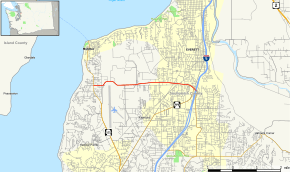
State Route 526 (SR 526) is a 4.52-mile-long (7.27 km) state highway in the U.S. state of Washington, located in Snohomish County. It has been named the Boeing Freeway for the Boeing Everett Factory, which the four-lane freeway serves. SR 526 travels east–west from SR 525 in Mukilteo to Interstate 5 (I-5), SR 99, and SR 527 in Everett. The highway serves as the main route to the Boeing factory as well as the city of Mukilteo and the ferry service to Whidbey Island.
Route description
SR 526 begins as 84th Street Southwest at a signalized intersection with SR 525, named the Mukilteo Speedway, at Nelsons Corner in Mukilteo. The highway travels east through a residential neighborhood, heading towards an intersection with Paine Field Boulevard, signed as SR 525 Spur, at the Future of Flight Aviation Center and Paine Field. SR 526 turns northeast as the four-lane continuation of Paine Field Boulevard, curving north around the north–south runway of Paine Field and south of Japanese Gulch, into the city of Everett. The highway becomes the controlled-access Boeing Freeway and passes under the Boeing Access Road, a taxiway that connects the Boeing Everett Factory to Paine Field.[3] SR 526 continues east and intersects Airport Road in a diamond interchange and Seaway Boulevard in a semi-directional T interchange, the main access roads to Paine Field and the Boeing factory, respectively, before widening to six lanes as it approaches its eastern terminus, an interchange with I-5.[4][5] The freeway travels through a diamond interchange with Evergreen Way, located east of a pedestrian bridge over SR 526 and south of Cascade High School, where traffic heading towards I-5 northbound on a left directional exit and traffic heading towards I-5 southbound splits into two lanes, a normal lane and a high-occupancy vehicle lane (HOV lane).[6] SR 526 continues east, briefly paralleling the Interurban Trail,[7] before the freeway travels towards I-5 on flyover ramps and the highway terminates at the northern terminus of SR 99 and the northern terminus of SR 527.[8][9][10]
Every year, the Washington State Department of Transportation (WSDOT) conducts a series of surveys on its highways in the state to measure traffic volume. This is expressed in terms of average annual daily traffic (AADT), which is a measure of traffic volume for any average day of the year. In 2013, WSDOT calculated that the busiest section of SR 526 was its interchange with Evergreen Way, carrying 75,000 vehicles, while the least busiest section of the highway was its western terminus at SR 525, carrying 8,500 vehicles.[11] SR 526 is designated as part of the National Highway System for its whole length,[12] classifying it as important to the national economy, defense, and mobility.[13] WSDOT designates the entire route of SR 526 as a Highway of Statewide Significance,[14] which includes highways that connect major communities in the state of Washington.[15]
History
SR 526 was established during the 1964 state highway renumbering as the successor to SSH 1I between Mukilteo and Everett. The highways were preceded by the Mukilteo-Everett wagon road that was opened on August 14, 1914, traveling east along Possession Sound between Mukilteo and Everett, later renamed to Mukilteo Boulevard during the 1920s.[16] SSH 1I was designated in 1937 along the route of Mukilteo Boulevard and a new highway connecting Mukilteo to U.S. Route 99 (US 99) in Lynnwood,[17] traveling in a 10.63-mile (17.11 km) circular arc.[18][19] SSH 1I was split into SR 525 from Lynnwood to Mukilteo and SR 526 from Mukilteo to Everett during the 1964 state highway renumbering.[20][21] The eastern terminus of SR 526, an interchange with I-5 in Everett, was completed in February 1965 and later became the southern terminus of SR 529 until 1991.[22][23] The interchange was later converted to a single-point urban interchange in 2007 as part of a WSDOT project to improve I-5 through Everett.[24]
The current freeway alignment was completed in the early 1980s. When Boeing expanded their factory in the early 1990s, the state of Washington required that Boeing pay for upgrades to the connection between SR 526 and I-5.[25] These upgrades resulted in a direct connection being built to connect SR 526 to I-5 north, whereas previously one had to travel south on SR 527 in order to connect to I-5 north. Additional upgrades included an HOV queue lane for the I-5 southbound on-ramp, and the construction of sound walls along the freeway.
Until 2000, SR 526 and 84th St. in Mukilteo was a continuous alignment. When Paine Field Blvd. (SR 525 Spur) was completed in 2000, the alignment was changed to make the SR 526 expressway and Paine Field Blvd. continuous. The new intersection with 84th St. facilitate the creation of a new Boeing museum, the Future of Flight Aviation Center & Boeing Tour.
There are tentative plans to realign SR 525 to intersect with SR 526 near the head of Japanese Gulch, in order to facilitate a new ferry dock in Mukilteo and to avoid the population center of the city. While the plans for the new dock have been finalized, no plans have been presented for such a connection, aside from the construction of SR 525 Spur.
Exit list
The entire highway is in Snohomish County.
| Location | mi[1] | km | Destinations | Notes | |||
|---|---|---|---|---|---|---|---|
| Mukilteo | 0.00 | 0.00 | Continues as 84th Street | ||||
| 0.40 | 0.64 | ||||||
| Everett | 0.80 | 1.29 | Boeing Receiving | At-grade intersection | |||
| West end of freeway | |||||||
| 1.45 | 2.33 | Airport Road – Paine Field | |||||
| 1.97 | 3.17 | Seaway Boulevard | |||||
| 3.54 | 5.70 | Evergreen Way | |||||
| East end of freeway | |||||||
| 4.52 | 7.27 | ||||||
| At-grade intersection, continues as SR 527 | |||||||
| 1.000 mi = 1.609 km; 1.000 km = 0.621 mi | |||||||
References
- 1 2 Finch, Mark, ed. (March 4, 2014). State Highway Log: Planning Report 2013, SR 2 to SR 971 (PDF) (Report). Washington State Department of Transportation. pp. 1659–1662. Retrieved May 28, 2014.
- ↑ "47.17.740: State route No. 526". Revised Code of Washington. Washington State Legislature. 1970. Retrieved May 28, 2014.
- ↑ Gilmore, Susan (June 30, 2002). "Bumper to Bumper: Straight talk on S-curves, traffic lingo". The Seattle Times. Retrieved May 28, 2014.
- ↑ "SR 526: Junction Airport Road" (PDF). Washington State Department of Transportation. February 13, 2012. Retrieved May 28, 2014.
- ↑ "SR 526: Junction Seaway Boulevard" (PDF). Washington State Department of Transportation. February 13, 2012. Retrieved May 28, 2014.
- ↑ "SR 526: Junction Evergreen Way" (PDF). Washington State Department of Transportation. September 27, 2011. Retrieved May 28, 2014.
- ↑ Interurban Trail (PDF) (Map). Community Transit. 2014. Retrieved May 28, 2014.
- ↑ "SR 5 - Exit 189: Junction SR 99/SR 526/SR 527" (PDF). Washington State Department of Transportation. January 13, 2013. Retrieved May 28, 2014.
- ↑ Google (May 28, 2014). "State Route 526" (Map). Google Maps. Google. Retrieved May 28, 2014.
- ↑ Washington State Highways, 2011–2012 (PDF) (Map). 1:842,000. Washington State Department of Transportation. 2011. Retrieved May 28, 2014.
- ↑ 2013 Annual Traffic Report (PDF) (Report). Washington State Department of Transportation. 2013. pp. 198–199. Retrieved May 28, 2014.
- ↑ National Highway System: Marysville, WA (PDF) (Map). Federal Highway Administration. October 1, 2012. Retrieved May 28, 2014.
- ↑ "What is the National Highway System?". Federal Highway Administration. September 26, 2012. Retrieved May 28, 2014.
- ↑ "Transportation Commission List of Highways of Statewide Significance" (PDF). Washington State Transportation Commission. July 26, 2009. Retrieved May 28, 2014.
- ↑ Lorenzo, Judy. "Highways of Statewide Significance". Washington State Department of Transportation. Retrieved May 28, 2014.
- ↑ Riddle, Margaret (December 30, 2007). "Hundreds celebrate the opening of the Mukilteo-to-Everett road (future Mukilteo Boulevard) on August 5, 1914.". HistoryLink. Retrieved May 28, 2014.
- ↑ Washington State Legislature (March 18, 1937). "Chapter 207: Classification of Public Highways". Session Laws of the State of Washington. Session Laws of the State of Washington (1937 ed.). Olympia, Washington: Washington State Legislature. p. 996.
Secondary State Highway No. 1I; beginning at Everett on Primary State Highway No. 1, thence in a westerly direction by the most feasible route to Mukilteo, thence in a southeasterly direction by the most feasible route to a junction with Primary State Highway No. 1 in the vicinity south of Everett.
- ↑ Annual Traffic Report, 1960 (PDF) (Report). Washington State Highway Commission, Department of Highways. 1960. pp. 149–151, 154. Retrieved May 28, 2014.
- ↑ Seattle, 1958 (JPG) (Map). 1:250,000. United States Geological Survey. 1958. Retrieved May 28, 2014.
- ↑ Prahl, C. G. (December 1, 1965). "Identification of State Highways" (PDF). Washington State Highway Commission, Department of Highways. Retrieved May 28, 2014.
- ↑ Seattle, 1965 (JPG) (Map). 1:250,000. United States Geological Survey. 1965. Retrieved May 28, 2014.
- ↑ Dougherty, Phil (March 24, 2008). "Interstate 5 is completed from Everett to Seattle on February 3, 1965.". HistoryLink. Retrieved May 28, 2014.
- ↑ Washington House of Representatives (1991). "Chapter 342, Laws of 1991: State Highway Routes – Revisons To (House Bill 5801)". Washington State Legislature.
Sec. 42. RCW 47.17.752 and 1971 ex.s. c 73 s 19 are each amended to read as follows: A state highway to be known as state route number 529 is established as follows: Beginning at a junction with state route number 5 in Everett, thence westerly and northerly through Everett to a junction with state route number 528 in Marysville.
- ↑ "I-5 41st Street Interchange" (PDF). Washington State Department of Transportation. April 2007. Retrieved May 28, 2014.
- ↑ Tetra Tech Inca. "SR 526 and I-5 Interchange and Flyover Ramp". Retrieved 7 January 2011.