Washington State Route 544
| ||||
|---|---|---|---|---|
|
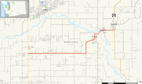
Map of Whatcom County in northwestern Washington with SR 544 highlighted in red | ||||
| Route information | ||||
| Auxiliary route of [[Interstate 5 (Washington) |]] | ||||
| Defined by RCW 47.17.800 | ||||
| Maintained by WSDOT | ||||
| Length: | 8.94 mi[1] (14.39 km) | |||
| Existed: | 1969 – present | |||
| Major junctions | ||||
| West end: |
| |||
| East end: |
| |||
| Location | ||||
| Counties: | Whatcom | |||
| Highway system | ||||
| ||||

SR 544, Pole Road/Everson Goshen Road, is a state route in Washington state, United States. It goes from Lynden to Nooksack.
Route description
State Route 544 starts eastbound from SR 539, (called Guide Meridian road) and heads due east along Pole Road until it meets Everson-Goshen Road and turns north.
The highway then follows a series of local roads of various names and crosses the Nooksack River in the town of Everson, Washington at turns east down Main Street/Columbia Avenue into its twin-town of Nooksack, Washington and ends at SR 9.
History
SR 544 was initially part of SSH 1A. Then, in the 1964 renumbering, it became SR 544.
Major intersections
The entire route is in Whatcom County.
| Location | mi[1] | km | Destinations | Notes | |
|---|---|---|---|---|---|
| | 0.00 | 0.00 | |||
| Nooksack | 8.94 | 14.39 | |||
| 1.000 mi = 1.609 km; 1.000 km = 0.621 mi | |||||
References
- 1 2 Washington State Department of Transportation. "State Highway Log, 2006" (PDF). Retrieved April 22, 2007.
External links
This article is issued from Wikipedia - version of the 12/21/2015. The text is available under the Creative Commons Attribution/Share Alike but additional terms may apply for the media files.