Indianapolis
| Indianapolis, Indiana | |||
|---|---|---|---|
| Consolidated city-county | |||
| City of Indianapolis and Marion County | |||
|
Clockwise from top: Downtown Indianapolis from IUPUI, Indiana Statehouse, Lucas Oil Stadium, Indianapolis Motor Speedway, Indiana World War Memorial Plaza, and the Soldiers' and Sailors' Monument. | |||
| |||
| Nickname(s): "Indy"; "Circle City"; "Crossroads of America"; "Naptown"; "Racing Capital of the World"; "Amateur Sports Capital of the World" | |||
 Location of Indianapolis in Marion County and Indiana | |||
 Indianapolis Location of the city of Indianapolis, Indiana | |||
| Coordinates: 39°46′N 86°9′W / 39.767°N 86.150°W | |||
| Country | United States | ||
| State | Indiana | ||
| County | Marion | ||
| Founded | January 6, 1821[1] | ||
| Incorporated (town) | September 3, 1832[1] | ||
| Incorporated (city) | March 30, 1847[1] | ||
| City-county consolidation | January 1, 1970 | ||
| Government | |||
| • Type | Mayor-council | ||
| • Body | Indianapolis City-County Council | ||
| • Mayor | Joseph H. Hogsett (D) | ||
| Area | |||
| • Consolidated city-county | 372 sq mi (963.5 km2) | ||
| • Land | 365.1 sq mi (945.6 km2) | ||
| • Water | 6.9 sq mi (17.9 km2) | ||
| Elevation | 715 ft (218 m) | ||
| Population (2010)[2][3] | |||
| • Consolidated city-county | 820,445 | ||
| • Estimate (2015[4]) | 853,173 | ||
| • Rank |
1st in Marion County 1st in Indiana 3rd largest State Capital 14th in the United States | ||
| • Density | 2,273/sq mi (861/km2) | ||
| • Urban | 1,487,483 (US: 33rd) | ||
| • Metro | 1,756,241 (US: 33rd) | ||
| • CSA | 2,080,782 (US: 26th) | ||
| Demonym(s) | Indianapolitan[5] | ||
| Time zone | EST (UTC-5) | ||
| • Summer (DST) | EDT (UTC-4) | ||
| ZIP Codes |
61 total ZIP codes:
| ||
| Area code(s) | 317/463 | ||
| FIPS code | 18-36003[6] | ||
| Website |
www | ||


Indianapolis (pronounced /ˌɪndiəˈnæpəlɪs/[7][8][9]), is the capital and largest city of the U.S. state of Indiana and the seat of Marion County. It is in the East North Central region of the Midwestern United States. With an estimated population of 853,173 in 2015, Indianapolis is the second most populous city in the Midwest, after Chicago, and 14th largest in the U.S.[10] The city is the economic and cultural center of the Indianapolis metropolitan area, home to 2 million people, the 34th most populous metropolitan statistical area in the U.S. Its combined statistical area ranks 26th, with 2.4 million inhabitants. Indianapolis covers 372 square miles (963.5 km²), making it the 16th largest city by land area in the U.S.
Founded in 1821 as a planned city for the new seat of the government of Indiana, Indianapolis was platted by Alexander Ralston and Elias Pym Fordham on a 1-square-mile (2.6 km2) grid adjacent to the White River. The city grew beyond the Mile Square, as completion of the National Road and advent of the railroad solidified the city's position as a manufacturing and transportation hub. Indianapolis is within a single-day drive of 70 percent of the nation's population, lending to its nickname as the "Crossroads of America."[11][12] Anchoring the 26th largest economic region in the U.S., the city's economy is based primarily on business services, transportation and logistics, education, financial services, hospitality and tourism, and distribution services.[13][14] Indianapolis has developed niche markets in amateur sports and auto racing.[14][15] The city is perhaps best known for annually hosting the world's largest single-day sporting event, the Indianapolis 500.[16]
The city's philanthropic community, led by the Lilly Endowment, has been instrumental in the development of its cultural institutions, including The Children's Museum of Indianapolis, Indianapolis Zoo, and Indiana Landmarks.[17][18][19][20] The city is notable as headquarters for the American Legion and home to a significant collection of monuments dedicated to veterans and war dead, the most in the U.S. outside of Washington, D.C.[21][22] Since the 1970 city-county consolidation, known as Unigov, local government administration has operated under the direction of an elected 25-member city-county council, headed by the mayor. Indianapolis is considered a "high sufficiency" global city.[23]
History
_(14803447463).jpg)

In 1816, the year Indiana gained statehood, the U.S. Congress donated four sections of federal land to establish a permanent seat of state government.[24] Two years later, under the Treaty of St. Mary's (1818), the Delaware relinquished title to their tribal lands in central Indiana, agreeing to leave the area by 1821.[25] This tract of land, which was called the New Purchase, included the site selected for the new state capital in 1820.[26]
The availability of new federal lands for purchase in central Indiana attracted settlers, many of them descendants of families from northwestern Europe. Although many of these first European and American setters were Protestants, a large proportion of the early Irish and German immigrants were Catholics. Few African Americans lived in central Indiana before 1840.[27] The first European Americans to permanently settle in the area that became Indianapolis were either the McCormick or Pogue families. The McCormicks are generally considered to be the town's first permanent settlers; however, some historians believe George Pogue and family may have arrived first, on March 2, 1819, and settled in a log cabin along the creek that was later called Pogue's Run. Other historians have argued as early as 1822 that John Wesley McCormick, his family, and employees became the first European American settlers in the area, settling near the White River in February 1820.[28]
On January 11, 1820, the Indiana General Assembly authorized a committee to select a site in central Indiana for the new state capital.[29] The state legislature approved the site, adopting the name Indianapolis on January 6, 1821.[1] In April, Alexander Ralston and Elias Pym Fordham were appointed to survey and design a town plan for the new settlement.[30] Indianapolis became a seat of county government on December 31, 1821, when Marion County, was established. A combined county and town government continued until 1832, when Indianapolis incorporated as a town. Indianapolis became an incorporated city effective March 30, 1847. Samuel Henderson, the city's first mayor, led the new city government, which included a seven-member city council. In 1853, voters approved a new city charter that provided for an elected mayor and a fourteen-member city council. The city charter continued to be revised as Indianapolis expanded.[31] Effective January 1, 1825, the seat of state government relocated to Indianapolis from Corydon, Indiana. In addition to state government offices, a U.S. district court was established at Indianapolis in 1825.[32]
Growth occurred with the opening of the National Road through the town in 1827, the first major federally funded highway in the United States.[33] A small segment of the ultimately failed Indiana Central Canal was opened in 1839.[34] The first railroad to serve Indianapolis, the Jeffersonville, Madison and Indianapolis Railroad, began operation in 1847, and subsequent railroad connections fostered growth.[35] Indianapolis Union Station was the first of its kind in the world when it opened in 1853.[36]

During the American Civil War, Indianapolis was loyal to the Union cause. Governor Oliver P. Morton, a major supporter of President Abraham Lincoln, quickly made Indianapolis a rallying place for Union army troops. On February 11, 1861, president-elect Lincoln arrived in the city, en route to Washington, D.C. for his presidential inauguration, marking the first visit from a president-elect in the city's history.[37] On April 16, 1861, the first orders were issued to form Indiana's first regiments and establish Indianapolis as a headquarters the state's volunteer soldiers.[38][39] Within a week, more than 12,000 recruits signed up to fight for the Union.[40]
Indianapolis became a major logistics hub during the war, establishing the city as a crucial military base.[41][42] Between 1860 and 1870, the city's population more than doubled.[35] An estimated 4,000 men from Indianapolis served in 39 regiments, and an estimated 700 died during the war.[43] On May 20, 1863, Union soldiers attempted to disrupt a statewide Democratic convention at Indianapolis, forcing the proceedings to be adjourned, sarcastically referred to as the Battle of Pogue's Run.[44] Fear turned to panic in July 1863, during Morgan's Raid into southern Indiana, but Confederate forces turned east toward Ohio, never reaching Indianapolis.[45] On April 30, 1865, Lincoln's funeral train made a stop at Indianapolis, where an estimated crowd of more than 100,000 people passed the assassinated president's bier at the Indiana Statehouse.[42][46]

Following the Civil War, Indianapolis experienced tremendous growth and prosperity. In 1880, Indianapolis was the world's third largest pork packing city, after Chicago and Cincinnati, and the second largest railroad center in the United States by 1888.[47][48] By 1890, the city's population surpassed 100,000.[35] Some of the city's most notable businesses were founded during this period of growth and innovation, including L. S. Ayres (1872), Eli Lilly and Company (1876), Madame C.J. Walker Manufacturing Company (1910), and Allison Transmission (1915). Once home to 60 automakers, Indianapolis rivaled Detroit as a center of automobile manufacturing.[49] The Soldiers' and Sailors' Monument, dedicated on May 15, 1902, would later become an iconic symbol of the city.[50] Ray Harroun won the inaugural running of the Indianapolis 500, held May 30, 1911 at Indianapolis Motor Speedway.
Indianapolis was one of the hardest hit cities in the Great Flood of 1913, resulting in five known deaths[51][52][53] and the displacement of 7,000 families.[54]

The city was an early focus of labor organization.[35] The Indianapolis Street Car Strike of 1913 and subsequent police mutiny and riots led to the creation of the state's earliest labor-protection laws, including a minimum wage, regular work weeks, and improved working conditions.[55] The International Typographical Union and United Mine Workers of America were among several influential labor unions to be based in the city.[35]
Indianapolis served as a stop on the Underground Railroad, and up to the time of the Great Migration in the early 20th century, the city had a higher black population (nearly 10%) than any other city in the Northern States.[56] Led by D. C. Stephenson, the Indiana Klan became the most powerful political and social organization in Indianapolis from 1921 through 1928, controlling City Council, the Board of School Commissioners, and the Board of County Commissioners. More than 40% of native-born white males in Indianapolis claimed membership in the Klan. Race relations would continue to be problematic throughout the 20th century. Though Indianapolis abolished segregated schools before Brown v. Board of Education, the later action of court-ordered desegregation busing by Judge Samuel Hugh Dillin proved controversial.[57] On April 4, 1968, Robert F. Kennedy delivered one of the most highly regarded speeches in 20th century American history from the city, urging calm after the assassination of civil rights leader Martin Luther King Jr.[58][59][60]

Under the mayoral administration of Richard Lugar, the city and county governments restructured, consolidating most public services into a new entity called Unigov. The plan removed redundancies, captured increasingly suburbanizing tax revenue, and created a Republican political machine that dominated Indianapolis politics until the 2000s.[61][62] Unigov went into effect on January 1, 1970, increasing the city's land area by 308.2 square miles (798 km2) and population by 268,366 people.[63][64] It was the first major city-county consolidation to occur in the United States without a referendum since the creation of the City of Greater New York in 1898.[65]
Amid the changes in government and growth, the city invested in an aggressive strategy to brand Indianapolis as a sport tourism destination. Under the administration of the city's longest-serving mayor, William Hudnut (1976–1992), millions of dollars were poured into sport facilities.[15] Throughout the 1980s, $122 million in public and private funding built the Indianapolis Tennis Center, Major Taylor Velodrome, Indiana University Natatorium, Carroll Track and Soccer Stadium, and RCA Dome.[15] The latter project secured the 1984 relocation of the NFL Baltimore Colts and the 1987 Pan American Games.[15] The economic development strategy succeeded in revitalizing the central business district through the 1990s, with the openings of the Indianapolis Zoo (1988), Canal Walk (1989–2001),[34] Circle Centre Mall (1995), Victory Field (1996), and Bankers Life Fieldhouse (1999).
During the 2000s, the city and state continued investing heavily in infrastructure projects, including two of the largest building projects in the city's history: the $1.1 billion Col. H. Weir Cook Terminal and $720 million Lucas Oil Stadium.[66][67] Construction began in 2011 on DigIndy, a $1.9 billion project to correct the city's combined sewer overflows (CSOs) by 2025.[68]
Geography
Indianapolis is located in the East North Central region of the Midwestern United States, in central Indiana. According to the United States Census Bureau, the Indianapolis (balance) encompasses a total area of 368.2 square miles (954 km2), of which 361.5 square miles (936 km2) is land and 6.7 square miles (17 km2) is water. The consolidated city boundaries are coterminous with Marion County, with the exception of the autonomous municipalities of Beech Grove, Lawrence, Southport, and Speedway.[35][69] Indianapolis is the 16th largest city by land area in the United States.
Topography

Indianapolis is situated within the Tipton Till Plain, a flat to gently sloping terrain underlain by glacial deposits known as till.[71] The lowest point in the city is about 650 feet (198 m) above mean sea level, with the highest natural elevation at about 900 feet (274 m) above sea level.[71] Few hills or short ridges, known as kames, rise about 100 feet (30 m) to 130 feet (40 m) above the surrounding terrain.[71] The city lies just north of the Indiana Uplands, a region characterized by rolling hills and high limestone content. The city is also situated within the EPA's Eastern Corn Belt Plains ecoregion, an area of the United States known for its fertile agricultural land.[72]
Topographic relief slopes gently toward the White River and its two primary tributaries, Fall and Eagle creeks. In total, there are about 35 streams in the city, including Indian Creek and Pogue's Run.[73] Major bodies of water include Indian Lake, Geist Reservoir, and Eagle Creek Reservoir.
Cityscape


Indianapolis is a planned city. On January 11, 1820, the Indiana General Assembly authorized a committee to select a site in central Indiana for the new state capital, appointing Alexander Ralston and Elias Pym Fordham to survey and design a town plan for Indianapolis. Ralston had been a surveyor for the French architect Pierre L'Enfant, assisting him with the plan for Washington, D.C. Ralston's original plan for Indianapolis called for a town of 1 square mile (2.6 km2), near the confluence of the White River and Fall Creek.[74] The plan, known as the Mile Square, is bounded by East, West, North, and South streets, centered on a traffic circle, called Monument Circle (originally Governor's Circle).[75] Four diagonal streets radiated a block from Monument Circle: Massachusetts, Virginia, Kentucky, and Indiana avenues.[76] The city's address numbering system begins at the intersection of Washington and Meridian streets.[77] Before its submersion into a sanitary tunnel, Pogue's Run was included into the plan, disrupting the rectilinear street grid to the southeast.
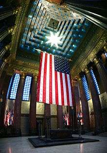
Noted as one of the finest examples of City Beautiful movement design in the United States, the seven-block Indiana World War Memorial Plaza Historic District began construction in 1921 in downtown Indianapolis.[78][79] The National Historic Landmark includes the Neoclassical American Legion and Central Library buildings, Depew Memorial Fountain, several sculptures and memorials, and open space, hosting many annual civic events.[79]
After completion of the Soldiers' and Sailors' Monument, an ordinance was passed in 1905 restricting building heights on the traffic circle to 86 ft (26 m) to protect views of the 284 ft (87 m) monument.[80] The ordinance was revised in 1922, permitting buildings to rise to 108 ft (33 m), with an additional 42 ft (13 m) allowable with a series of setbacks.[80] A citywide height restriction ordinance was instituted in 1912, barring structures over 200 ft (61 m).[81] Completed in 1962, the Indianapolis City-County Building was the first skyscraper in the city, surpassing the Soldiers' and Sailors' Monument in height by nearly 100 ft (30 m).[82] A building boom, lasting from 1982 to 1990, saw the construction of six of the city's ten tallest buildings.[83] The tallest is Chase Tower, completed in 1990 at 811 ft (247 m).[84]
Indiana limestone is the signature building material in Indianapolis, widely included in the city's many monuments, churches, academic, government, and civic buildings.[85]
Neighborhoods

The city is divided into 99 community areas for statistical purposes, though many smaller neighborhoods exist within these areas.[87] Indianapolis' neighborhoods are difficult to delineate because the city lacks historical ethnic divisions, like in Chicago, or physical boundaries, seen in Pittsburgh or Cincinnati.[88] Instead, most neighborhoods are subtle in their distinctions.[88]
The Indianapolis Historic Preservation Commission recognizes several neighborhoods as historic districts, including: Central Court, Chatham Arch, Cottage Home, Golden Hill, Herron-Morton Place, Lockerbie Square, Old Northside, and Oliver Johnson's Woods. Expansion of the interurban system at the turn of the 20th century facilitated growth of several streetcar suburbs, including Broad Ripple, Irvington, University Heights, and Woodruff Place.[88]
The post–World War II economic expansion and subsequent suburbanization had a profound impact on the physical development of the city's neighborhoods. From 1950 to 1970, 97,000 housing units were built in Marion County.[88] Most of this new construction occurred outside Center Township, expediting out-migration from the city's urban neighborhoods to suburban areas, such as Castleton, Eagledale, and Nora. Between 1950 and 1990, over 155,000 residents left Center Township, resulting in urban blight and disinvestment.[88]
Since the 2000s, downtown Indianapolis and surrounding neighborhoods, like Fountain Square, have seen increased reinvestment attributed to nationwide demographic trends, driven by empty nesters and millennials.[89] By 2020, downtown is projected to have 30,000 residential units, compared to 18,300 in 2010.[90] Renewed interest in urban living has been met with some dispute regarding gentrification and affordable housing.[91][92][93]
Climate


Indianapolis is in the humid continental climate zone (Köppen: Dfa) using the 0 °C (32 °F) isotherm, experiencing four distinct seasons.[94] The city is in USDA hardiness zone 6a.[95] Using Köppen's original −3 °C (27 °F) isotherm the city is in the far northern periphery of the humid subtropical climate (Cfa) instead.[96]
Typically, summers are hot, humid, and wet. Winters are generally cold with moderate snowfall. The July daily average temperature is 75.4 °F (24.1 °C). High temperatures reach or exceed 90 °F (32 °C) an average of 18 days each year,[97] and occasionally exceed 95 °F (35 °C). Spring and autumn are usually pleasant, if at times unpredictable; midday temperature drops exceeding 30 °F or 17 °C are common during March and April, and instances of very warm days (80 °F or 27 °C) followed within 36 hours by snowfall are not unusual during these months. Winters are cold, with an average January temperature of 28.1 °F (−2.2 °C). Temperatures dip to 0 °F (−18 °C) or below an average of 4.7 nights per year.[97]
The rainiest months occur in the spring and summer, with slightly higher averages during May, June, and July. May is typically the wettest, with an average of 5.05 inches (12.8 cm) of precipitation.[97] Most rain is derived from thunderstorm activity; there is no distinct dry season, although occasional droughts occur. Severe weather is not uncommon, particularly in the spring and summer months; the city experiences an average of 20 thunderstorm days annually.[98]
The city's average annual precipitation is 42.4 inches (108 cm), with snowfall averaging 25.9 inches (66 cm) per season. Official temperature extremes range from 106 °F (41 °C), set on July 14, 1936,[99] to −27 °F (−33 °C), set on January 19, 1994.[99][100]
| Climate data for Indianapolis (Indianapolis International Airport), 1981–2010 normals,[lower-alpha 1] extremes 1871–present[lower-alpha 2] | |||||||||||||
|---|---|---|---|---|---|---|---|---|---|---|---|---|---|
| Month | Jan | Feb | Mar | Apr | May | Jun | Jul | Aug | Sep | Oct | Nov | Dec | Year |
| Record high °F (°C) | 71 (22) |
76 (24) |
85 (29) |
90 (32) |
96 (36) |
104 (40) |
106 (41) |
103 (39) |
100 (38) |
91 (33) |
81 (27) |
74 (23) |
106 (41) |
| Mean maximum °F (°C) | 58.3 (14.6) |
63.3 (17.4) |
75.3 (24.1) |
81.4 (27.4) |
86.2 (30.1) |
91.9 (33.3) |
93.6 (34.2) |
92.5 (33.6) |
89.8 (32.1) |
82.1 (27.8) |
71.3 (21.8) |
59.8 (15.4) |
94.8 (34.9) |
| Average high °F (°C) | 35.6 (2) |
40.2 (4.6) |
51.7 (10.9) |
63.4 (17.4) |
72.8 (22.7) |
81.9 (27.7) |
85.0 (29.4) |
84.0 (28.9) |
77.6 (25.3) |
65.3 (18.5) |
52.2 (11.2) |
38.9 (3.8) |
62.4 (16.9) |
| Average low °F (°C) | 20.5 (−6.4) |
23.9 (−4.5) |
32.8 (0.4) |
42.7 (5.9) |
52.6 (11.4) |
62.1 (16.7) |
65.8 (18.8) |
64.4 (18) |
56.2 (13.4) |
44.7 (7.1) |
35.1 (1.7) |
24.4 (−4.2) |
43.8 (6.6) |
| Mean minimum °F (°C) | −2.5 (−19.2) |
3.4 (−15.9) |
14.9 (−9.5) |
26.6 (−3) |
37.7 (3.2) |
48.2 (9) |
55.0 (12.8) |
53.8 (12.1) |
40.6 (4.8) |
29.6 (−1.3) |
20.0 (−6.7) |
3.3 (−15.9) |
−7.8 (−22.1) |
| Record low °F (°C) | −27 (−33) |
−21 (−29) |
−7 (−22) |
18 (−8) |
28 (−2) |
37 (3) |
46 (8) |
41 (5) |
30 (−1) |
20 (−7) |
−5 (−21) |
−23 (−31) |
−27 (−33) |
| Average precipitation inches (mm) | 2.66 (67.6) |
2.32 (58.9) |
3.56 (90.4) |
3.81 (96.8) |
5.05 (128.3) |
4.25 (108) |
4.55 (115.6) |
3.13 (79.5) |
3.12 (79.2) |
3.12 (79.2) |
3.70 (94) |
3.17 (80.5) |
42.44 (1,078) |
| Average snowfall inches (cm) | 8.6 (21.8) |
6.5 (16.5) |
2.6 (6.6) |
0.2 (0.5) |
trace | 0 (0) |
0 (0) |
0 (0) |
0 (0) |
0.4 (1) |
0.7 (1.8) |
6.9 (17.5) |
25.9 (65.8) |
| Average precipitation days (≥ 0.01 in) | 12.1 | 10.0 | 11.9 | 12.0 | 13.1 | 11.1 | 10.5 | 8.5 | 8.1 | 8.6 | 10.8 | 12.5 | 129.2 |
| Average snowy days (≥ 0.1 in) | 7.5 | 5.4 | 2.5 | 0.4 | 0 | 0 | 0 | 0 | 0 | 0.2 | 1.2 | 6.3 | 23.5 |
| Average relative humidity (%) | 75.0 | 73.6 | 69.9 | 65.6 | 67.1 | 68.4 | 72.8 | 75.4 | 74.4 | 71.6 | 75.5 | 78.0 | 72.3 |
| Mean monthly sunshine hours | 132.1 | 145.7 | 178.3 | 214.8 | 264.7 | 287.2 | 295.2 | 273.7 | 232.6 | 196.6 | 117.1 | 102.4 | 2,440.4 |
| Percent possible sunshine | 44 | 49 | 48 | 54 | 59 | 64 | 65 | 64 | 62 | 57 | 39 | 35 | 55 |
| Source: NOAA (relative humidity and sun 1961–1990)[97][101][102] | |||||||||||||
Demographics

| Historical population | |||
|---|---|---|---|
| Census | Pop. | %± | |
| 1840 | 2,695 | — | |
| 1850 | 8,091 | 200.2% | |
| 1860 | 18,611 | 130.0% | |
| 1870 | 48,244 | 159.2% | |
| 1880 | 75,056 | 55.6% | |
| 1890 | 105,436 | 40.5% | |
| 1900 | 169,164 | 60.4% | |
| 1910 | 233,650 | 38.1% | |
| 1920 | 314,194 | 34.5% | |
| 1930 | 364,161 | 15.9% | |
| 1940 | 386,972 | 6.3% | |
| 1950 | 427,173 | 10.4% | |
| 1960 | 476,258 | 11.5% | |
| 1970 | 744,624 | 56.3% | |
| 1980 | 700,807 | −5.9% | |
| 1990 | 731,327 | 4.4% | |
| 2000 | 781,926 | 6.9% | |
| 2010 | 820,445 | 4.9% | |
| Est. 2015 | 853,173 | [4] | 4.0% |
| [2][103][104] | |||

The U.S. Census Bureau considers Indianapolis as two entities: the consolidated city and the city's remainder, or balance. The consolidated city covers an area known as Unigov, coterminous with Marion County, except the independent municipalities of Beech Grove, Lawrence, Speedway, and Southport. The city's balance excludes the populations of 11 semi-autonomous municipalities that are included in totals for the consolidated city.[69] These are Clermont, Crows Nest, Cumberland, Homecroft, Meridian Hills, North Crows Nest, Rocky Ripple, Spring Hill, Warren Park, Williams Creek, and Wynnedale. The city's consolidated population for the year 2012 was 844,220.[69] The city's remainder, or balance, population was estimated at 834,852 for 2012,[2] a 2% increase over the total population of 820,445 reported in the 2010 U.S. Census.[3][106] As of 2010, the city's population density was 2,270 persons per square mile.[2] Indianapolis is the most populous city in Indiana, containing 12.8% of the state's total population.[69]
The Indianapolis metropolitan area (MSA) (officially known as the Indianapolis–Carmel–Anderson MSA) consists of Marion County and the surrounding counties of Boone, Brown, Hamilton, Hancock, Hendricks, Johnson, Morgan, Putnam, and Shelby. As of 2012, the metropolitan area's population was 1,798,634, the most populous in Indiana.[107] Indianapolis anchors the larger Indianapolis–Carmel–Muncie combined statistical area (CSA), with a population of 2,336,237. Indianapolis is also situated within the Great Lakes Megalopolis, one of 11 megaregions in the U.S.
According to the U.S. Census of 2010, 97.2% of the Indianapolis population was reported as one race: 61.8% White, 27.5% Black or African American, 2.1% Asian (0.4% Burmese, 0.4% Indian, 0.3% Chinese, 0.3% Filipino, 0.1% Korean, 0.1% Vietnamese, 0.1% Japanese, 0.1% Thai, 0.1% other Asian); 0.3% American Indian, and 5.5% as other. The remaining 2.8% of the population was reported as multiracial (two or more races).[106] The city's Hispanic or Latino community comprised 9.4% of the city's population in the 2010 U.S. Census: 6.9% Mexican, .4% Puerto Rican, .1% Cuban, and 2% as other.[106]
| Racial composition | 2014[108] | 2010[109] | 1990[110] | 1970[110] |
|---|---|---|---|---|
| White | 62.0% | 61.8% | 75.8% | 81.6% |
| —Non-Hispanic | 58.6% | 58.6% | 75.2% | 80.9%[111] |
| Black or African American | 27.9% | 27.5% | 22.6% | 18.0% |
| Hispanic or Latino (of any race) | 9.6% | 9.4% | 1.1% | 0.8%[111] |
| Asian | 2.4% | 2.1% | 0.9% | 0.1% |
As of 2010, the median age for Indianapolis was 33.7 years. Age distribution for the city's inhabitants was 25% under the age of 18; 4.4% were between 18 and 21; 16.3% were age 21 to 65; and 13.1% were age 65 or older.[106] For every 100 females there were 93 males. For every 100 females age 18 and over, there were 90 males.[112]
The U.S. Census for 2010 reported 332,199 households in Indianapolis, with an average household size of 2.42 and an average family size of 3.08.[106] Of the total households, 59.3% were family households, with 28.2% of these including the family's own children under the age of 18; 36.5% were husband-wife families; 17.2% had a female householder (with no husband present) and 5.6% had a male householder (with no wife present). The remaining 40.7% were non-family households.[106] As of 2010, 32% of the non-family households included individuals living alone, 8.3% of these households included individuals age 65 years of age or older.[106]
The U.S. Census Bureau's 2007–2011 American Community Survey indicated the median household income for Indianapolis city was $42,704, and the median family income was $53,161.[113] Median income for males working full-time, year-round, was $42,101, compared to $34,788 for females. Per capita income for the city was $24,430, 14.7% of families and 18.9% of the city's total population living below the poverty line (28.3% were under the age of 18 and 9.2% were age 65 or older).[113]
As of 2015, the Indianapolis metropolitan area had the 18th highest percentage of LGBT residents in the U.S., with 4.2% of residents identifying as gay, lesbian, bisexual, or transgender.[114]
Religion

Of the 42.42% of the city's residents who identify as religious, Roman Catholics make up the largest group, at 11.31%.[115] The second highest religious group in the city are Baptists at 10.31%, with Methodists following behind at 4.97%. Presbyterians make up 2.13% of the city's religiously affiliated population, followed by Pentecostals and Lutherans. Another 8.57% are affiliated with other Christian faiths.[115] 0.32% of religiously affiliated persons identified themselves as following Eastern religions, while 0.68% of the religiously affiliated population identified as Jewish, and 0.29% as Muslim.[115] According to the nonpartisan and nonprofit Public Religion Research Institute's American Values Atlas, 22% of residents identify as religiously "unaffiliated," consistent with the national average of 22.7%.[116]
Indianapolis is the seat of the Roman Catholic Archdiocese of Indianapolis, based from Saints Peter and Paul Cathedral. In October 2016, Pope Francis announced that current archbishop Joseph William Tobin, C.Ss.R., would be created cardinal in November 2016, making him the first sitting archbishop of Indianapolis to serve in this role. The Archdiocese of Indianapolis also operates Bishop Simon Bruté College Seminary, affiliated with Marian University, while the Christian Theological Seminary is affiliated with the Christian Church (Disciples of Christ). Indianapolis is the seat of the Episcopal Diocese of Indianapolis, based from Christ Church Cathedral. The Indiana-Kentucky Synod of the Evangelical Lutheran Church in America and the Indiana Conference of the United Methodist Church are also based in the city.
Economy
Contributing to an annual gross metropolitan product (GMP) of $125.9 billion, the Indianapolis metropolitan area is the 26th largest economic region in the U.S. and 42nd largest in the world.[117] The largest industry sectors by employment are manufacturing, health care and social services, and retail trade.[118] Compared to Indiana as a whole, the Indianapolis metropolitan area has a lower proportion of manufacturing jobs and a higher concentration of jobs in wholesale trade; administrative, support, and waste management; professional, scientific, and technical services; and transportation and warehousing.[118] The city's major exports include pharmaceuticals, motor vehicle parts, medical equipment and supplies, engine and power equipment, and aircraft products and parts.[11]
| Top publicly traded companies based in Indianapolis | |||||
| Corporation | Rank | ||||
| Anthem Inc. | 33 | ||||
| Eli Lilly and Company | 141 | ||||
| Simon Property Group | 488 | ||||
| Calumet Specialty Products Partners | 571 | ||||
| hhgregg | 937 | ||||
| Allison Transmission Holdings | 979 | ||||
| Notes | |||||
| Rankings for fiscal year ended 2016. | |||||
| Source: Fortune[119] | |||||

As of 2016, three Fortune 500 companies were based in the city: health insurance company Anthem Inc.; pharmaceutical company Eli Lilly; and Simon Property Group, the largest real estate investment trust in the U.S.[119] Columbus, Indiana-based Cummins will open its Global Distribution Headquarters in downtown Indianapolis in late-2016.[120] The city is home to three Fortune 1000 companies: hydrocarbon manufacturer Calumet Specialty Products Partners; retailer hhgregg; and automotive transmission manufacturer Allison Transmission.[119] Other notable companies based in the Indianapolis metropolitan area include: financial services holding company CNO Financial Group (Carmel); media conglomerate Emmis Communications; retailers Finish Line, Lids (Zionsville), and Marsh Supermarkets (Fishers); regional airline owner Republic Airways; truckload carrier Celadon Group; and restaurant chains Noble Roman's, Scotty's Brewhouse, and Steak 'n Shake.
Like many Midwestern cities, recent deindustrialization trends have had a significant impact on Indianapolis' economy. Once home to 60 automakers, Indianapolis rivaled Detroit as a center of automobile manufacturing in the early 20th century.[49] Between 1990 and 2012, approximately 26,900 manufacturing jobs were lost in the city, including the automotive plant closures of Chrysler, Ford, and General Motors.[121] In 2016, Carrier Corporation announced the closure of its Indianapolis plant, moving 1,400 manufacturing jobs to Mexico.[122] Since 1915, Rolls-Royce Holdings has had operations in Indianapolis.[123] It is the third largest manufacturing employer and thirteenth largest employer overall in the city, with a workforce of 4,300 in aircraft engine development and manufacturing.[124]

Biotechnology, life sciences, and health care are major sectors of Indianapolis' economy. As of 2016, Eli Lilly and Company was the largest employer in the city, with 11,382 workers.[125] The North American headquarters for Roche Diagnostics and Dow AgroSciences are also located in the city.[126] A 2014 report by Battelle Memorial Institute and Biotechnology Industry Organization indicated that the Indianapolis–Carmel–Anderson MSA was the only U.S. metropolitan area to have specialized employment concentrations in all five bioscience sectors evaluated in the study: agricultural feedstock and chemicals; bioscience-related distribution; drugs and pharmaceuticals; medical devices and equipment; and research, testing, and medical laboratories.[127] The regional health care providers of Community Health Network, Franciscan Health, Indiana University Health, and St. Vincent Health have a combined workforce of 43,700.[128]
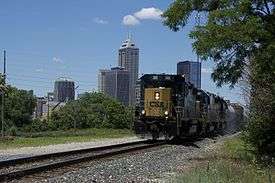
Four Interstate Highways converge in Indianapolis, with two additional auxiliary routes. The city is also the hub of Indiana's 4,700-mile (7,600 km) railroad infrastructure, the ninth most extensive in the U.S.[129][130] These distinctions have allowed the city to become an important logistics center, home to 1,500 distribution firms, employing 100,000 workers.[131] As home to the second largest FedEx Express hub in the world, Indianapolis International Airport ranks as the sixth busiest U.S. airport in terms of air cargo, handling over 1 million tons and employing 6,600 in 2015.[132][133] The city is an important hub for CSX Transportation, home to its division headquarters, an intermodal terminal, and classification yard (in the suburb of Avon).[134] Amtrak's Beech Grove Shops, in the enclave of Beech Grove, serve as its primary heavy maintenance and overhaul facility, while the Indianapolis Distribution Center is the company's largest material and supply terminal.[135][136] In 2011, the Indianapolis metropolitan area was ranked as the tenth largest inland port in the U.S. in terms of origin-destination freight tonnage.[121]
The hospitality industry is an increasingly vital sector to the Indianapolis economy. A Rockport Analytics study found that 27.4 million visitors generated a record $4.5 billion in 2015.[137] Indianapolis has long been a sport tourism destination, but has more recently relied on conventions.[138] The Indiana Convention Center (ICC) and Lucas Oil Stadium are considered mega convention center facilities, with a combined 750,000 feet (230,000 m) of exhibition space.[139] ICC is connected to 12 hotels and 4,700 hotel rooms, the most of any U.S. convention center.[140] In 2008, the facility hosted 42 national conventions with an attendance of 317,815; in 2014, it hosted 106 for an attendance of 635,701.[138] Since 2003, Indianapolis has hosted Gen Con, one of the largest gaming conventions in North America.[141] USA Today named Indianapolis the best convention city in 2014.[142]
Indianapolis is the fourth fastest high-tech job growth area in the U.S., with 28,500 information technology-related jobs at such companies as Angie's List, Appirio, BrightPoint, Interactive Intelligence, and Salesforce Marketing Cloud.[143][144]
Culture and contemporary life

In 1999, Indianapolis designated six cultural districts to capitalize on cultural institutions within historically significant neighborhoods unique to the city's heritage. These include Broad Ripple Village, Canal and White River State Park, Fountain Square, Indiana Avenue, Mass Ave, and Wholesale.[146] A seventh cultural district, Market East, was designated in 2014.[147] After 12 years of planning and six years of construction, the Indianapolis Cultural Trail: A Legacy of Gene and Marilyn Glick officially opened in 2013.[148] The $62.5 million public-private partnership resulted in 8 miles (13 km) of urban bike and pedestrian corridors linking six cultural districts with neighborhoods, IUPUI, and every significant arts, cultural, heritage, sports, and entertainment venue downtown.[149][150][151][152]
Indianapolis is home to dozens of annual festivals and events showcasing local culture. Notable events include the "Month of May" (a series of celebrations leading to the Indianapolis 500), Circle City IN Pride, Indiana Black Expo, Indiana State Fair, and Historic Irvington Halloween Festival.
Visual arts
.jpg)
Founded in 1883, the Indianapolis Museum of Art (IMA) is the ninth oldest[153][note 1] and eighth largest encyclopedic art museum in the U.S.[155][note 2] The permanent collection comprises over 54,000 works, including African, American, Asian, and European pieces.[156] In addition to its collections, the museum consists of 100 Acres: The Virginia B. Fairbanks Art and Nature Park; Oldfields, a restored house museum and estate once owned by Josiah K. Lilly, Jr.; and restored gardens and grounds originally designed by Percival Gallagher of the Olmsted Brothers firm.[157] The IMA also owns the Miller House, a Mid-Century modern home designed by Eero Saarinen located in Columbus, Indiana.[158] The museum's holdings demonstrate the institution's emphasis on the connections among art, design, and the natural environment.[154]
The Indianapolis Art Center, located in Broad Ripple Village, was founded in 1934 by the Works Project Administration. The center opened at its Michael Graves-designed building in 1996, including three public art galleries, 11 studios, a library, auditorium, and ArtsPark along the White River.[159] The Indianapolis Museum of Contemporary Art was established in 2001, and is located in The Murphy Art Center in Fountain Square. In 2014, the museum opened a second public gallery in The Alexander Hotel at CityWay in downtown Indianapolis.[160]
Eiteljorg Museum of American Indians and Western Art opened in 1989 at White River State Park as the only Native American art museum in the Midwest.[161] Indiana University – Purdue University Indianapolis (IUPUI) contains the Herron School of Art and Design. Established in 1902, the school's first core faculty included Impressionist painters of the Hoosier Group: T. C. Steele, J. Ottis Adams, William Forsyth, Richard Gruelle, and Otto Stark. The university's public art collection is extensive, with more than 30 works.
Performing arts
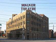
Indianapolis' most notable performing arts venues are located in the Mass Ave cultural district or Downtown. Located on Monument Circle since 1916, the 1,786-seat Hilbert Circle Theatre is the current home of the Indianapolis Symphony Orchestra. The Indiana Theatre opened as a movie palace on Washington Street in 1927, currently housing the Indiana Repertory Theatre, a regional repertory theatre. Madame Walker Theatre Center also opened that year on Indiana Avenue, in the heart of the city's African American neighborhood. The theater is named for Madame C.J. Walker, an African American entrepreneur, philanthropist, and activist who began her beauty empire in Indianapolis.
Mass Ave is home to the Old National Centre, Phoenix Theatre, and the Athenæum (Das Deutsche Haus). Old National Centre at the Murat Shrine is the oldest stage house in Indianapolis, opened in 1909.[163] The building is a prime example of Moorish Revival architecture and features a 2,600-seat performing arts theatre, 1,800-seat concert hall, and 600-seat multi-functional room, hosting approximately 300 public and private events throughout the year.[163] The nonprofit Phoenix Theatre focuses on contemporary theatrical productions.[164] The Athenӕum, houses the American Cabaret Theater and Young Actors Theater.
Other notable venues include the Indianapolis Artsgarden, a performing arts center suspended over the intersection of Washington and Illinois streets, Clowes Memorial Hall on the Butler University campus, and The Emerson Theater in Little Flower.
Indianapolis is home to Bands of America (BOA), a nationwide organization of high school marching, concert, and jazz bands, and the international headquarters of Drum Corps International (DCI), a professional drum and bugle corps association.[165] Annual music events include the International Violin Competition of Indianapolis, Midwest Music Summit, and Indy Jazz Fest. The Heartland Film Festival, Indianapolis International Film Festival, Indianapolis Jewish Film Festival, Indianapolis Theatre Fringe Festival, and the Indianapolis Alternative Media Festival are annual events held in the city.
Literature
Indianapolis was at the center of the Golden Age of Indiana Literature, from 1870 to 1920.[166] Several notable poets and writers based in the city achieved national prominence and critical acclaim during this period, including James Whitcomb Riley, Booth Tarkington, and Meredith Nicholson.[12] In A History of Indiana Literature, Arthur W. Shumaker remarked on the era's influence: "It was the age of famous men and their famous books. In it Indiana, and particularly Indianapolis, became a literary center which in many ways rivaled the East."[167] A 1947 study found that Indiana authors ranked second to New York in the number of bestsellers produced in the previous 40 years.[166] Located in Lockerbie Square, the James Whitcomb Riley Museum Home has been a National Historic Landmark since 1962.
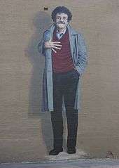
Perhaps the city's most famous 20th century writer was Kurt Vonnegut, known for his darkly satirical and controversial bestselling novel Slaughterhouse-Five (1969). Vonnegut became known for including at least one character in his novels from Indianapolis.[168] Upon returning to the city in 1986, Vonnegut acknowledged the influence the city had on his writings: "All my jokes are Indianapolis. All my attitudes are Indianapolis. My adenoids are Indianapolis. If I ever severed myself from Indianapolis, I would be out of business. What people like about me is Indianapolis."[168][169] The Kurt Vonnegut Memorial Library opened in 2010 in downtown Indianapolis.[169]
Indianapolis is the current home to bestselling young adult fiction writer John Green, known for his critically acclaimed 2012 novel The Fault in Our Stars, set in the city.[170]
Museums and monuments

The Children's Museum of Indianapolis is the largest of its kind in the world.[171] In total, the museum has 472,900 square feet (43,933.85 m2) of floor space.[172] The museum has a collection of over 120,000 artifacts,[173] divided into three collections: Natural World, Cultural World, and American.[174] The museum's collection includes the Broad Ripple Park Carousel, a National Historic Landmark. Because of its leadership and innovations, the museum is a world leader in its field.[175] Child and Parents magazine have both ranked the museum as the best children's museum in the United States.[176] The "institution is considered the gold standard of museums for children."[177] The museum is one of the city's most popular attractions, with 1.2 million visitors in 2014.[178]
The Indianapolis Motor Speedway Museum (in Speedway) exhibits an extensive collection of auto racing memorabilia showcasing various motorsports and automotive history.[179][180] The museum is the permanent home of the Borg-Warner Trophy, presented to Indianapolis 500 winners.[16] Daily grounds and track tours are also based at the museum.[180] The NCAA Hall of Champions opened in 2000 at White River State Park housing collegiate athletic artifacts and interactive exhibits covering all 23 NCAA-sanctioned sports.[181][182]

Indianapolis is home to several museums and organizations relating to Indiana history, including the Colonel Eli Lilly Civil War Museum, Hook's Drug Store Museum, Indiana Historical Society, Indiana State Library and Historical Bureau, Indiana State Museum, Indiana Medical History Museum, Indiana Landmarks, and the Indiana World War Memorial Military Museum. The Benjamin Harrison Presidential Site, located in the Old Northside Historic District, is open for daily tours and includes thousands of books and memorabilia relating to the 23rd President of the United States. The city contains the largest collection of monuments dedicated to veterans and war dead in the country, outside of Washington, D.C.[21][22] Notable sites include:
- Crown Hill National Cemetery
- Indiana World War Memorial Plaza
- Landmark for Peace Memorial
- Medal of Honor Memorial
- Project 9/11 Indianapolis
- Soldiers' and Sailors' Monument
- USS Indianapolis National Memorial
Food and drink

Indianapolis has an emerging food scene as well as established eateries.[184] Founded in 1821 as the city's public market, the Indianapolis City Market has served the community from its current building since 1886. Prior to World War II, the City Market and neighboring Tomlinson Hall (since demolished) were home to meat and vegetable vendors. As consumer habits evolved and residents moved from the central city, the City Market transitioned from a traditional marketplace to a food court, a function it retains today.[185] Opened in 1902, St. Elmo Steak House is well known for its signature shrimp cocktail, named by the Travel Channel as the "world's spiciest food." In 2012, it was recognized by the James Beard Foundation as one of "America's Classics."[186] The Slippery Noodle Inn, a blues bar and restaurant, is the oldest continuously operating tavern in Indiana, having opened in 1850.[187] The Jazz Kitchen, opened in 1994, was recognized in 2011 by OpenTable as one the "top 50 late night dining hotspots" in the U.S.[188]
In 2016, Condé Nast Traveler named Indianapolis the "most underrated food city in the U.S.," while ranking Milktooth as one of the best restaurants in the world.[189][190] Food & Wine called Indianapolis the "rising star of the Midwest," recognizing Milktooth, Rook, Amelia's, and Bluebeard, all in Fletcher Place.[191][192] Several Indianapolis chefs and restaurateurs have been semifinalists in the James Beard Foundation Awards in recent years.[193] Microbreweries are quickly becoming a staple in the city, increasing fivefold since 2009.[194] There are now about 50 craft brewers in Indianapolis, with Sun King Brewing being the largest.[195]
For some time, Indianapolis was known as the "100 Percent American City" for its racial and ethnic homogeneity.[196] Historically, these factors, as well as low taxes and wages, provided chain restaurants a relatively stable market to test dining preferences before expanding nationwide. As a result, the Indianapolis metropolitan area had the highest concentration of chain restaurants per capita of any market in the U.S. in 2008, with one chain restaurant for every 1,459 people—44% higher than the national average.[197] In recent years, immigrants have opened some 800 ethnic restaurants.[196]
Sports

Two major league sports teams are based in Indianapolis: the Indianapolis Colts of the National Football League (NFL) and the Indiana Pacers of the National Basketball Association (NBA). Originally the Baltimore Colts, the franchise has been based in Indianapolis since relocating there in 1984. The Colts' tenure in Indianapolis has produced 11 division championships, two conference championships, and two Super Bowl appearances. Quarterback Peyton Manning led the team to win Super Bowl XLI in the 2006 NFL season. Lucas Oil Stadium replaced the team's first home, the RCA Dome, in 2008. Founded in 1967, the Indiana Pacers began in the American Basketball Association (ABA), joining the NBA when the leagues merged in 1976. Prior to joining the NBA, the Pacers won three division titles and three championships (1970, 1972, 1973). Since the merger, the Pacers have won one conference title and six division titles, most recently in 2014.

Founded in 2000, the Indiana Fever of the Women's National Basketball Association (WNBA) have won three conference titles and one championship in 2012. The Fever and Pacers share Bankers Life Fieldhouse, which replaced Market Square Arena in 1999. The Indianapolis Indians of the International League (AAA) is the second oldest minor league franchise in American professional baseball, established in 1902.[198] The Indians have won 25 division titles, 14 league titles, and seven championships, most recently in 2000. Since 1996, the team has played at Victory Field, which replaced Bush Stadium. Of the 160 teams comprising Minor League Baseball, the Indians had the highest attendance during the 2016 season.[199] Established in 2013, Indy Eleven of the North American Soccer League (NASL) plays from IU Michael A. Carroll Stadium. Indy Fuel of the ECHL was founded in 2014 and plays from Indiana Farmers Coliseum.
Butler University and Indiana University – Purdue University Indianapolis (IUPUI) are NCAA Division I schools based in the city. The Butler Bulldogs compete in the Big East Conference, except for Butler Bulldogs football, which plays in the Pioneer Football League FCS. The Butler Bulldogs men's basketball team were runners-up in the 2010 and 2011 NCAA Men's Division I Basketball Championship Games. The IUPUI Jaguars compete in the Summit League.

Traditionally, Indianapolis' Hinkle Fieldhouse was the hub for Hoosier Hysteria, a general excitement around the game of basketball throughout the state, specifically the Indiana High School Boys Basketball Tournament.[200] Hinkle, a National Historic Landmark, was opened in 1928 as the world's largest basketball arena, with seating for 15,000.[201] It is regarded as "Indiana's Basketball Cathedral." Perhaps the most notable game was the 1954 state championship, which inspired the critically acclaimed 1986 film, Hoosiers.[202]
Indianapolis has been called the "Amateur Sports Capital of the World."[35][203] The National Collegiate Athletic Association (NCAA), the main governing body for U.S. collegiate sports, and the National Federation of State High School Associations are based in Indianapolis. The city is home to three NCAA athletic conferences: the Horizon League (Division I); the Great Lakes Valley Conference (Division II); and the Heartland Collegiate Athletic Conference (Division III). Indianapolis is also home to three national sport governing bodies, as recognized by the United States Olympic Committee: USA Gymnastics; USA Diving; and USA Track & Field.[204]
Indianapolis hosts numerous sporting events annually, including the Circle City Classic (1983–present), NFL Scouting Combine (1987–present), and Big Ten Football Championship Game (2011–present). Indianapolis is tied with New York City for having hosted the second most NCAA Men's Division I Basketball Championships (1980, 1991, 1997, 2000, 2006, 2010, and 2015).[205] The city will host the men's Final Four next in 2021.[206] Notable past events include the NBA All-Star Game (1985), Pan American Games X (1987), US Open Series Indianapolis Tennis Championships (1988–2009), World Rowing Championships (1994), World Police and Fire Games (2001), FIBA Basketball World Cup (2002), and Super Bowl XLVI (2012).
Indianapolis is home to the OneAmerica 500 Festival Mini-Marathon, the largest half marathon and seventh largest running event in the U.S.[207] The mini-marathon is held the first weekend of May as part of the 500 Festival, leading up to the Indianapolis 500. As of 2013, it had sold out for 12 consecutive years, with 35,000 participants.[208] Held in autumn, the Monumental Marathon is also among the largest in the U.S., with nearly 14,000 entrants in 2015.[209]
Motorsports
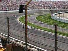
Indianapolis is a major center for motorsports. Since 1911, Indianapolis Motor Speedway (IMS) (in the enclave of Speedway, Indiana) has been the site of the Indianapolis 500, an open-wheel automobile race held each Memorial Day weekend. Considered part of the Triple Crown of Motorsport, the Indianapolis 500 is the world's largest single-day sporting event, hosting more than 257,000 permanent seats.[16] The city is headquarters to INDYCAR, the sanctioning body for American Championship car racing, and more than 500 motorsports companies and racing teams, employing some 10,000 people in the region.[210] Indianapolis is so well connected with racing that it has inspired the name "IndyCar," used for both the competition and type of car used in it.[211]
Since 1994, IMS has hosted Super Weekend at the Brickyard, a series of automobile races leading to one of NASCAR's highest attended events, the Sprint Cup Series Brickyard 400.[212] Since 2014, IMS has also hosted the Verizon IndyCar Series Grand Prix of Indianapolis. IMS hosted the seventh round of the 2016 Red Bull Air Race World Championship.[213] Lucas Oil Raceway at Indianapolis, in nearby Hendricks County, is home to the National Hot Rod Association (NHRA) U.S. Nationals, the most prestigious drag racing event in the world, held annually each Labor Day weekend.[214]
Parks and recreation
.jpg)
Indy Parks and Recreation maintains nearly 200 parks covering 11,246 acres (4,551 ha).[215] Eagle Creek Park is the largest and most visited park in the city and ranks among the largest municipal parks in the U.S., covering 4,766 acres (1,929 ha).[216] Fishing, sailing, kayaking, canoeing, and swimming are popular activities at Eagle Creek Reservoir. Recreational trails, including the Canal Walk, Pleasant Run Trail, and Monon Trail, are used for walking, running, and cycling, accommodating 2.8 million users in 2012.[217] There are 13 public golf courses in the city.[218] Military Park was established as the city's first public park in 1852.[219] By the 20th century, the city enlisted landscape architect George Kessler to conceive a framework for Indianapolis' modern parks system.[220] Kessler's 1909 Indianapolis Park and Boulevard Plan linked notable parks, such as Brookside, Ellenberger, and Garfield, with a system of parkways following the city's waterways.[221] In 2003, the system's 3,474 acres (1,406 ha) were added to the National Register of Historic Places.[222]

Two state parks are located in Marion County: Fort Harrison in Lawrence and White River downtown. Encompassing 250 acres (100 ha), White River is the city's major urban park, home to the Indianapolis Zoo and White River Gardens.[223] As of 2015, the zoo was home to nearly 1,400 animals of 214 species and 31,000 plants, including many threatened and endangered species.[224][223] The Indianapolis Zoo is the largest privately funded zoo in the U.S. and is one of the city's most visited attractions, with 1.2 million guests in 2014.[19][178] Indianapolis lies about 50 miles (80 km) north of two state forests, Morgan–Monroe and Yellowwood, and one national forest, Hoosier. Crown Hill Cemetery, the third largest private cemetery in the U.S., covers 555 acres (225 ha) on the city's north side and is home to more than 250 species of trees and shrubs.[225]
According to the Trust for Public Land's 2016 ParkScore Index, Indianapolis ranks 95th of the 100 largest U.S. cities in accessibility to public parks and open space, with some 68% of residents under served.[226] The city's vast land area and low public funding contributed to the ranking.[226]
Government
_-_panoramio_-_WSaves_PublicArt_(3).jpg)
Indianapolis has a consolidated city-county government known as Unigov, a status it has held since 1970. Under this system, many functions of the city and county governments are consolidated, though some remain separate. The city has a mayor-council form of government. The executive branch is headed by an elected mayor, who serves as the chief executive of both the city and Marion County. Joseph H. "Joe" Hogsett, a Democrat, is the 49th and current mayor of Indianapolis. The mayor appoints deputy mayors, department heads, and members of various boards and commissions. The legislative body for the city and county is the City-County Council, consisting of 25 members all of whom represent geographic districts. The council passes ordinances for the city and county and also makes appointments to certain boards and commissions.
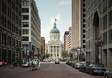
As the state capital, Indianapolis is the seat of Indiana's state government. The Indiana Statehouse, located downtown, houses the executive, legislative, and judicial branches of state government, including the office of the governor, Indiana General Assembly, Indiana Court of Appeals, and the Indiana Supreme Court. Most of the state's bureaus are located in the Indiana Government Center North. The Indiana Governor's Residence is located on Meridian Street in the Butler-Tarkington neighborhood, about 5 miles (8.0 km) north of downtown.
Most of Indianapolis is within the 7th Congressional District of Indiana, represented by André Carson (D). Northern portions of the city are in the 5th District, represented by Susan Brooks (R).[227] Federal field offices are located in the Birch Bayh Federal Building and United States Courthouse (which houses the United States District Court for the Southern District of Indiana) and Minton-Capehart Federal Building.
Politics

Until the late-1990s, Indianapolis was considered one of the most conservative major cities in the United States, but this trend has since gradually reversed. Unigov's absorption of Republican-leaning townships outside the city proper is considered the main factor in this shift.[61] Republicans held the mayor's office for 32 years (1967–1999), and controlled the City-County Council from its inception in 1970 to 2003.[61] More recently, Republicans have generally been stronger in the southern and western parts of the county (Decatur, Franklin, Perry, and Wayne, townships), whereas Democrats have been stronger in the central and northern parts of the county (Center, Pike, and Washington townships). Republican and Democratic prevalence is split in Warren and Lawrence townships.[228] As of 2014, the city is regarded as politically moderate.[229]
Republican Greg Ballard chose not to run for a third term in the 2015 mayoral election.[230] Republican Chuck Brewer and Democrat Joe Hogsett were the candidates to replace him. The candidates had similar plans for addressing the city's issues, and the commonality between them contributed to a very low voter turnout.[231] Hogsett previously held public office as Indiana Secretary of State, and had served in government for over 30 years, giving him greater name recognition than Brewer, a local restaurateur.[232] Hogsett was elected with 63% of the vote, officially taking office on January 1, 2016.[232] The 2015 City-County Council elections also left Democrats in control of City-County Council, holding a 13–12 majority over Republicans, only the second time since the creation of Unigov that Democrats controlled both the mayor's office and council.[233]
Public safety
| Indianapolis | |
| Crime rates (2014) | |
| Crime type | Rate* |
|---|---|
| Homicide: | 15.85 |
| Forcible rape: | 66.76 |
| Robbery: | 443.7 |
| Aggravated assault: | 728.35 |
| Total violent crime: | 1254.66 |
| Burglary: | 1412.78 |
| Larceny-theft: | 2806.91 |
| Motor vehicle theft: | 603.45 |
| Arson: | 31.58 |
| Total property crime: | 4823.14 |
| Notes * Number of reported crimes per 100,000 population. 2014 population: 858,238 |
|
| Source: 2014 FBI UCR Data | |
The Indianapolis Fire Department (IFD) provides fire protection services for 278 square miles (720 km2) of Marion County. IFD operates 44 stations, including 1,205 sworn firefighters. IFD responded to nearly 100,000 incidents in 2014.[234] As of 2016, Ernest Malone was the fire chief.[235] Indianapolis Metropolitan Police Department's (IMPD) jurisdiction covers most of Marion County, with the exception of Beech Grove, Lawrence, Speedway, and the Indianapolis Airport Authority.[236] In 2009, IMPD operated six precincts, including 1,617 sworn police personnel.[236] As of 2016, Troy Riggs was the chief of police.[237]
Indianapolis was ranked as the 33rd most dangerous city in the U.S. in the 2008–2009 edition of CQ Press's City Crime Rankings and the 22nd most dangerous city according to Yahoo! Finance in 2012.[238][239] Yahoo! Finance also reported that the city averaged 52.2 forcible rapes per 100,000 people, double the national average of 26.8 forcible rapes per 100,000 people.[239]
Between 2012 and 2014, the murder rate increased by 44%. There were 138 homicides in 2014, with 60% of victims being young black men.[240] With 144 criminal homicides, 2015 surpassed 1998 as the year with the most murder investigations in the city.[241] There were also 447 nonfatal shootings in 2015, representing a 24% increase over the 361 shootings recorded during the same time period in 2014.[241]
Education

Indianapolis has nine unified public school districts: Franklin Township Community School Corporation, MSD Decatur Township, MSD Lawrence Township, MSD Perry Township, MSD Pike Township, MSD Warren Township, MSD Washington Township, MSD Wayne Township, and Indianapolis Public Schools (IPS). IPS is the largest public school district in Indiana, serving nearly 30,000 students.[242] A number of private primary and secondary schools are operated through the Archdiocese of Indianapolis, charters, or other independent organizations. Public library services are provided to the citizens of Indianapolis and Marion County by the Indianapolis Public Library. Founded in 1873, the public library system includes the Central Library and 23 branches throughout the county. The Indianapolis Public Library served 4.2 million patrons in 2014, with a circulation of 15.9 million materials.[243]

Indiana University – Purdue University Indianapolis (IUPUI) was founded in 1969 after merging the branch campuses of Indiana University and Purdue University.[244] IUPUI's current enrollment is 30,105, the third largest in the state.[245] IUPUI has two colleges and 18 schools, including the Herron School of Art and Design, Robert H. McKinney School of Law, and School of Dentistry.[246] The Indiana University School of Medicine is the largest medical school in the United States.[124][247] The city is home to the largest campus for Ivy Tech, Central Indiana Region, a state-funded community college serving nearly 100,000 students across Indiana.[248]

Five private universities are based in Indianapolis. Established in 1855, Butler University is the oldest higher education institution in the city, with an undergraduate enrollment of about 4,000.[249] Affiliated with the Roman Catholic Church, Marian University was founded in 1936 when St. Francis Normal and Immaculate Conception Junior College merged, moving to Indianapolis in 1937. Marian has an enrollment of about 2,137 students.[250] Founded in 1902, the University of Indianapolis is affiliated with the United Methodist Church. The school's current enrollment is 4,169 students.[251] Martin University was founded in 1977 and is the state's only predominately black university.[252] Crossroads Bible College and Indiana Bible College are small Christian colleges located in the city.
Satellite campuses located in the city include Ball State University College of Architecture and Planning, Grace College, Indiana Institute of Technology, Indiana Wesleyan University, and Vincennes University.
Media

Indianapolis is served by various print media. Founded in 1903, The Indianapolis Star is the city's daily morning newspaper. The Star is owned by the Gannett Company, with a daily circulation of 127,064.[253] The Indianapolis News was the city's daily evening newspaper and oldest print media, published from 1869 to 1999. Notable weeklies include NUVO, an alternative weekly newspaper, the Indianapolis Recorder, a weekly newspaper serving the local African American community, the Indianapolis Business Journal, reporting on local real estate, and the Southside Times. Indianapolis Monthly is the city's monthly lifestyle publication.
Broadcast television network affiliates include WTTV (CBS), WRTV (ABC), WISH-TV (The CW), WTHR-TV (NBC), WXIN-TV (Fox), WFYI-TV (PBS), WNDY-TV (MyNetworkTV), WDNI-CD (Telemundo), and WIPX-TV (Ion). The majority of commercial radio stations in the city are owned by Cumulus Media, Emmis Communications, iHeartMedia, and Radio One. Popular nationally syndicated radio program The Bob & Tom Show has been based at Indianapolis radio station WFBQ since 1983.[254] As of 2016, the Indianapolis metropolitan area was the 27th largest television market and 39th largest radio market in the U.S.[255][256][257][258]
Indianapolis natives Jane Pauley and David Letterman launched their notable broadcasting careers in local media, Pauley with WISH-TV and Letterman with WTHR-TV, respectively.[259][260] Movies at least partially filmed in the city include Speedway (1929),[261] To Please a Lady (1950),[262] Winning (1969),[263] Hoosiers (1986),[264] Eight Men Out (1988),[265] and Eagle Eye (2008).[266] Television series set in Indianapolis have included One Day at a Time; Good Morning, Miss Bliss; Men Behaving Badly; Close to Home;[267] the second season of anthology drama American Crime,[268] and HGTV's Good Bones.[269]
Infrastructure
Transportation

Indianapolis was founded on the White River under an incorrect assumption that it would serve as a major transportation artery, but the river proved difficult to navigate and too shallow during much of the year.[33] After the steamboat Robert Hanna ran aground along the river in 1831, no steamboat successfully returned to Indianapolis. Flatboats continued to transport goods along a portion of the river until new dams impeded their ability to navigate its waters.[270] The first major federally funded highway in the U.S., the National Road, reached Indianapolis in 1836,[33] followed by the railroad in 1847. By 1850, eight railroads converged in the city, ending its isolation from the rest of the country and ushering in a new era of growth.[271] Indianapolis Union Station opened in the Wholesale District on September 20, 1853 as the world's first union station.[36] Citizen's Street and Railway Company was established in 1864, operating the city's first mule-drawn streetcar line.[272][273] By 1890, electric-powered streetcars began running.[274] Opened in 1904, the Indianapolis Traction Terminal was the largest interurban station in the world, handling 500 trains daily and 7 million passengers annually.[275] Ultimately doomed by the automobile, the terminal closed in 1941, followed by the streetcar system in 1957.[276]

Indianapolis is intersected by four Interstate Highways: Interstate 65, Interstate 69, Interstate 70, and Interstate 74. Two auxiliary Interstate Highways are located in the metropolitan area; a bypass (Interstate 465) and connector (Interstate 865). The predominant mode of transportation is the automobile, with 92.6% of Indianapolis–Carmel–Anderson MSA residents commuting by car, most traveling alone (83.4%).[277] This reliance on the automobile has had a major impact on the city's development patterns, with Walk Score ranking Indianapolis as one of the least walkable large cities in the U.S.[278] Only 2.7% of residents walk or bike to work.[277] Despite this reliance, the city has encouraged enhanced bicycle and pedestrian infrastructure in recent years. Indianapolis includes some 75 miles (121 km) of trails and 90 miles (140 km) of on-street bike lanes.[279] A 27-station bike sharing system was inaugurated in 2014.[280] An electric carsharing program, BlueIndy, was launched in 2015. The program will ultimately include 500 electric cars and 200 charging stations throughout the city.[281]
The Indianapolis Public Transportation Corporation, branded as IndyGo, has operated the city's public transportation system since 1975. Recent efforts to expand mass transit in the metropolitan area have been initiated through a $1.2 billion regional bus rapid transit plan called Indy Connect.[282] The first segment to be constructed is Phase I of the Red Line, traveling 14 miles (23 km) from Broad Ripple Village to the University of Indianapolis.[283] In 2011, a private company called the Downtown Indianapolis Streetcar Corporation began studying the feasibility of a streetcar circulator for downtown Indianapolis.[276] Despite only 1% of residents commuting via public transportation,[277] IndyGo had a 2014 ridership of 10.3 million, the highest in 23 years.[284] In 2016, the Julia M. Carson Transit Center opened, the downtown hub for 27 bus routes.[285]
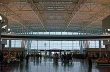
Indianapolis International Airport (IND) is the busiest airport in the state, serving 8 million passengers in 2015.[286] Completed in 2008, the Col. H. Weir Cook Terminal contains two concourses, 40 gates, and includes parking for 14,000 vehicles.[287] IND connects to 45 domestic and international destinations, averaging 143 daily departures.[286] As home to the second largest FedEx Express hub in the world, IND ranks as the sixth busiest U.S. airport in terms of air cargo, handling over 1 million tons in 2015.[132][288] The Indianapolis Airport Authority also manages Eagle Creek Airpark and the only public-use heliport in the state, the Indianapolis Downtown Heliport.[289]
Amtrak currently provides two intercity rail lines to Indianapolis via Union Station, serving about 30,000 passengers in 2015.[136] The Cardinal makes three weekly trips between New York City and Chicago, while the Hoosier State operates on the four days the Cardinal does not operate, running to Chicago. Indianapolis is a proposed connection on the Chicago Hub Network, a high-speed rail line that would run between Chicago and Cincinnati. Three intercity bus service providers stop in the city: Greyhound Lines and Burlington Trailways (via Union Station), and Megabus (via City Market).[290] The Indiana University Health People Mover opened in 2003 connecting Indiana University Health's medical centers with related facilities on the IUPUI campus. It is currently the lone example of commuter rail in Indianapolis and is also notable for being the only private transportation system in the U.S. elevated above public streets.[291][292]
Health care

Indianapolis Emergency Medical Services (IEMS) covers six townships within the city (Center, Franklin, Lawrence, Perry, Warren, and Washington) and the town of Speedway. IEMS responded to nearly 100,000 emergency dispatch calls in 2014.[293]
Indiana University Health's Academic Health Center encompasses Marion County, with the medical centers of University Hospital, Methodist Hospital, and Riley Hospital for Children. The Academic Health Center is anchored by the Indiana University School of Medicine, the second largest medical school in the U.S.[124][247] Riley Hospital for Children is among the nation's foremost pediatric health centers, recognized in all ten specialties by U.S. News and World Report, including top 25 honors in orthopedics (23), nephrology (22), gastroenterology and GI surgery (16), pulmonology (13), and urology (4).[294] The 430-bed facility also contains Indiana's only Pediatric Level I Trauma Center.[295]
Indianapolis' public medical center, the Sidney and Lois Eskenazi Hospital, reopened in 2013 after a $754 million project to replace Wishard Memorial Hospital on the IUPUI campus. Eskenazi includes an Adult Level I Trauma Center, 315 beds, and 275 exam rooms, annually serving 1.2 million outpatients.[296] Opened in 1932, the Richard L. Roudebush VA Medical Center is Indiana's tertiary referral hospital for former armed services personnel, treating more than 60,000 veterans annually.[297] Located on the city's far north side, St. Vincent Indianapolis Hospital is the flagship medical center of St. Vincent Health's 22-hospital system. St. Vincent Indianapolis includes Peyton Manning Children's Hospital, St. Vincent Heart Center of Indiana, St. Vincent Seton Specialty Hospital, and St. Vincent Women's Hospital. Franciscan Health Indianapolis' flagship medical center is located on the city's far south side.
Community Health Network includes four medical centers in Marion County, including Community Westview Hospital, Community Hospital South, Community Hospital North, and Community Hospital East. Community Hospital East is currently replacing its 60-year-old facility with a $175 million, 150-bed hospital to be completed in 2019.[298] The campus will also include a $120 million, 159-bed state-funded mental health and chronic addiction treatment facility. The Indiana Neuro-Diagnostic Institute will replace the antiquated Larue D. Carter Memorial Hospital in 2018.[299]
According to Indianapolis-based American College of Sports Medicine's 2016 American Fitness Index Data Report, the city scored last of the 50 largest U.S. metropolitan areas for health and community fitness.[300] Higher instances of obesity, coronary heart disease, diabetes, smoking, and asthma contributed to the ranking.[301]
Utilities

Electricity is provided by Indianapolis Power & Light (IPL), a subsidiary of AES Corporation.[302] IPL generates 3,343 MW of electricity at four power stations, two wind farms,[303] and 34 solar farms,[304] covering a service area of 528 square miles (1,370 km2).[305] Despite a portfolio comprised 100% of nonrenewable energy sources in 2007, IPL ended coal-firing operations at its Harding Street Station in 2016.[303] In 2016, Indianapolis had the second highest number of photovoltaics (PVs) per capita in the U.S.[304]
Citizens Energy Group, a public charitable trust, provides residents with natural gas, water, wastewater, and thermal services.[306][307] Covanta Energy operates a waste-to-energy plant in the city, processing solid waste for steam production.[307][308] Steam is sold to Citizens Thermal Energy's Perry K. Generating Station for the downtown Indianapolis district heating system, the second largest in the U.S.[309] Republic Services and Ray's Trash Service provides curbside solid waste and recycling removal.
Notable people
Sister cities
Indianapolis has six sister cities and two friendship cities as designated by Sister Cities International.[310]
Sister cities
 Campinas, São Paulo, Brazil (since 2009)
 Cologne, North Rhine-Westphalia, Germany (since 1988)
 Monza, Monza and Brianza, Lombardy, Italy (since 1993)
 Northamptonshire, England, United Kingdom (since 2009)
 Piran, Slovenia (since 2001)
 Taipei, Taiwan (since 1978)
Friendship cities
See also
Notes
- ↑ Mean monthly maxima and minima (i.e. the expected highest and lowest temperature readings at any point during the year or given month) calculated based on data at said location from 1981 to 2010.
- ↑ Official records for Indianapolis kept at downtown from February 1871 to December 1942, and at Indianapolis Int'l since January 1943. For more information, see Threadex
- ↑ The nine oldest museums in the U.S. are: Peabody Essex Museum, 1799; Wadsworth Atheneum, 1842; Metropolitan Museum of Art, 1870; Museum of Fine Arts, Boston, 1870; Philadelphia Museum of Art, 1876; Columbus Museum of Art, Ohio, 1878; Art Institute of Chicago, 1879; Cincinnati Art Museum, 1881; Portland Museum of Art, 1882; Indianapolis Museum of Art, 1883.[154]
- ↑ At 669,484 square feet (62,197.1 m2), the IMA is eighth largest in the U.S. in Main Museum Building space among the 130 respondents in the Association of Art Museum Directors 2010 Statistical Survey.[155]
References
- 1 2 3 4 Bodenhamer, David; Barrows, Robert, eds. (1994). The Encyclopedia of Indianapolis. Bloomington & Indianapolis: Indiana University Press. pp. 1479–80.
- 1 2 3 4 "Indianapolis (city (balance)), Indiana". U.S. Census Bureau. Retrieved November 20, 2013.
- 1 2 "U.S. Census Bureau Delivers Indiana's 2010 Census Population Totals". Archived from the original on February 13, 2011. Retrieved February 11, 2011.
- 1 2 "American FactFinder – Results (Indianapolis city (balance), Indiana)". United States Census Bureau. Retrieved May 27, 2016.
- ↑ "Definition of Indianapolitan". Merriam-Webster Dictionary. Retrieved August 1, 2016.
- ↑ "American FactFinder". United States Census Bureau. Archived from the original on September 11, 2013. Retrieved January 31, 2008.
- ↑ Jones, Daniel (2003) [1917]. Peter Roach, James Hartmann and Jane Setter, eds. English Pronouncing Dictionary. Cambridge: Cambridge University Press. ISBN 3-12-539683-2.
- ↑ "Indianapolis". Merriam-Webster Dictionary.
- ↑ "Indianapolis". Dictionary.com Unabridged. Random House.
- ↑ "American FactFinder – Results". United States Census Bureau, Population Division. Retrieved May 29, 2016.
- 1 2 "Metro Indianapolis Export Plan" (PDF). Indy Chamber. Retrieved August 16, 2016.
- 1 2 "Capital at the Crossroads of America–Indianapolis: A Discover Our Shared Heritage Travel Itinerary". National Park Service (U.S. Dept. of the Interior). Retrieved March 24, 2016.
- ↑ Analysis, U.S. Department of Commerce, BEA, Bureau of Economic. "Bureau of Economic Analysis". www.bea.gov. Retrieved January 16, 2016.
- 1 2 Rick Mattoon and Norman Wang (2014). "Industry clusters and economic development in the Seventh District's largest cities" (PDF). Economic Perspectives. pp. 56–58. Retrieved August 16, 2016.
- 1 2 3 4 Ted Greene and Jon Sweeney (January 20, 2012). Naptown to Super City (television broadcast). Indianapolis: WFYI-TV (PBS). Retrieved March 26, 2016.
- 1 2 3 "The Borg-Warner Trophy" (PDF). BorgWarner Inc. Retrieved April 27, 2016.
- ↑ "Lilly Endowment Annual Report 2014" (PDF). Lilly Endowment, Inc. Retrieved March 23, 2016.
- ↑ Bodenhamer, David; Barrows, Robert, eds. (1994). The Encyclopedia of Indianapolis. Bloomington & Indianapolis: Indiana University Press. pp. 914–916.
- 1 2 "Annual Reports". Indianapolis Zoological Society. Retrieved October 17, 2016.
- ↑ "About - Indiana Landmarks". Indiana Landmarks. Retrieved August 16, 2016.
- 1 2 Mitchell, Dawn (May 25, 2015). "Monumental Indianapolis: Touring Indianapolis memorials". The Indianapolis Star. Retrieved March 25, 2016.
- 1 2 "Message from the Executive Director". Indiana War Memorial. Retrieved March 25, 2016.
- ↑ "The World According to GAWC 2012". GAWC. Retrieved August 10, 2015.
- ↑ A. C. Howard (1857). A. C. Howard's Directory for the City of Indianapolis: Containing a Correct List of Citizens' Names, Their Residence and Place of Business, with a Historical Sketch of Indianapolis from its Earliest History to the Present Day. Indianapolis: A. C. Howard. p. 3. See also Hester Ann Hale (1987). Indianapolis, the First Century. Indianapolis: Marion County Historical Society. p. 9.
- ↑ Bodenhamer, David; Robert Graham Barrows; David Gordon Vanderstel (1994). The Encyclopedia of Indianapolis. Indiana University Press. ISBN 0-253-31222-1. p. 1042
- ↑ Brown, p. 1; Centennial History of Indianapolis, p. 26; and Howard, p. 2.
- ↑ Baer, p. 10 and 58.
- ↑ Brown, p. 2; Centennial History of Indianapolis, p. 6; and Hale, p. 8.
- ↑ Hale, p. 9.
- ↑ Hyman, p. 10, and William A. Browne Jr. (Summer 2013). "The Ralston Plan: Naming the Streets of Indianapolis". Traces of Indiana and Midwestern History. Indianapolis: Indiana Historical Society. 25 (3): 8–9. Accessed March 25, 2016.
- ↑ Brown, pp. 8, 46 and 49; Centennial History of Indianapolis, p. 30; Esarey, v. 3, pp. 42–43 and 201–2; and David J. Bodenhamer and Robert G. Barrows, eds. (1994). The Encyclopedia of Indianapolis. Bloomington and Indianapolis: Indiana University Press. pp. 1479–80. ISBN 0-253-31222-1.
- ↑ Bodenhamer and Barrows, eds., p. 967; Hale, p. 13; Howard, p. 26; and W. R. Holloway (1870). Indianapolis: A Historical and Statistical Sketch of the Railroad City, A Chronicle of its Social, Municipal, Commercial and Manufacturing Progress with Full Statistical Tables. Indianapolis: Indianapolis Journal.
- 1 2 3 Baer, p. 11, and Hyman, p. 34.
- 1 2 Bodenhamer, David; Barrows, Robert, eds. (1994). The Encyclopedia of Indianapolis. Bloomington & Indianapolis: Indiana University Press. pp. 395–396.
- 1 2 3 4 5 6 7 "Indianapolis". Encyclopædia Britannica. Retrieved June 13, 2016.
- 1 2 "Indianapolis Union Railroad Station". Discover Our Shared Heritage Travel Itinerary. Washington, D.C.: National Park Service. Retrieved August 11, 2015.
- ↑ Holliday, p. 24; Dunn, Greater Indianapolis, v. I, p. 217; and Leary, pp. 94–98.
- ↑ John D. Barnhart (September 1961). "The Impact of the Civil War on Indiana". Indiana Magazine of History. Bloomington: Indiana University. 57 (3): 186. Retrieved October 15, 2015.
- ↑ Joseph A. Parsons, Jr. (March 1958). "Indiana and the Call for Volunteers, April, 1861". Indiana Magazine of History. Bloomington: Indiana University. 54 (1): 5–7. Retrieved October 20, 2015.
- ↑ Emma Lou Thornbrough (1995). Indiana in the Civil War Era, 1850–1880. History of Indiana. III. Indianapolis: Indiana Historical Society. p. 124. ISBN 0-87195-050-2.
- ↑ Leary, p. 99.
- 1 2 Bodenhamer and Barrows, eds., p. 443.
- ↑ Leary, pp. 99, 113–14, and Bodenhamer and Barrows, eds., pp. 441, 443.
- ↑ Thornbrough, p. 202; Bodenhamer and Barrows, eds., p. 1121; and Kenneth M. Stampp (1949). Indiana Politics During the Civil War. Indiana Historical Collections. 31. Indianapolis: Indiana Historical Bureau. pp. 199–201. OCLC 952264.
- ↑ Barnhart, pp. 212-13, and John Holliday (1911). Indianapolis and the Civil War. E. J. Hecker. pp. 58–59.
- ↑ Dunn, v. I, p. 237.
- ↑ Bodenhamer, David; Barrows, Robert, eds. (1994). The Encyclopedia of Indianapolis. Bloomington & Indianapolis: Indiana University Press. p. 1483.
- ↑ Bodenhamer, David; Barrows, Robert, eds. (1994). The Encyclopedia of Indianapolis. Bloomington & Indianapolis: Indiana University Press. p. 23.
- 1 2 "Retro Indy: City came close to being "Motor City"". The Indianapolis Star. April 24, 2016. Retrieved April 27, 2016.
- ↑ James Philip Fadely (Winter 2006). "The Veteran and the Memorial: George J. Gangsdale and the Soldiers and Sailors Monument". Traces of Indiana and Midwestern History. Indianapolis: Indiana Historical Society. 18 (1): 33–35. Accessed March 26, 2016.
- ↑ "Community Profiles: Indianapolis, Indiana". The Great Flood of 1913, 100 Years Later. Silver Jackets. 2013. Retrieved July 29, 2013.
- ↑ Trudy E. Bell (Spring 2006). "Forgotten Waters: Indiana's Great Easter Flood of 1913". Traces of Indiana and Midwestern History. Indianapolis: Indiana Historical Society. 18 (2): 15.
- ↑ Unconfirmed deaths numbered as many as twenty-five. See Bodenhamer and Barrows, p. 582.
- ↑ Bodenhamer, David J., and Robert G. Barrows, eds. (1994). The Encyclopedia of Indianapolis. Bloomington and Indianapolis: Indiana University Press. pp. 581–582. ISBN 0-253-31222-1.
- ↑ Dunn, Jacob Piatt (1919). Indiana and Indianans. Volume III. Chicago & New York: American Historical Society. p. 1230.
- ↑ "Indianapolis" (PDF). Archived from the original (PDF) on September 26, 2006. Retrieved November 8, 2011.
- ↑ Cavazos, Shaina (August 17, 2016). "Racial Bias and the Crumbling of a City". The Atlantic. Retrieved September 22, 2016.
- ↑ Morning Edition. "Robert Kennedy: Delivering News of King's Death". NPR. Retrieved July 1, 2010.
- ↑ Higgins, Will (April 2, 2015). "April 4, 1968: How RFK saved Indianapolis". The Indianapolis Star. Retrieved March 26, 2016.
- ↑ "Top 100 American Speeches of the 20th Century". Retrieved August 1, 2016.
- 1 2 3 4 Bradner, Eric (August 29, 2010). "Indiana Democrats, African-Americans saw diminishing returns in 'Unigov'". Evansville Courier & Press. Retrieved March 26, 2016.
- ↑ Bodenhamer, David; Barrows, Robert, eds. (1994). The Encyclopedia of Indianapolis. Bloomington & Indianapolis: Indiana University Press. p. 1356.
- ↑ "Table 19. Population of the 100 Largest Urban Places: 1960". U.S. Census Bureau. Retrieved April 27, 2016.
- ↑ "Table 20. Population of the 100 Largest Urban Places: 1970". U.S. Census Bureau. Retrieved April 27, 2016.
- ↑ Bodenhamer, David; Barrows, Robert, eds. (1994). The Encyclopedia of Indianapolis. Bloomington & Indianapolis: Indiana University Press. pp. 1350–1353.
- ↑ "IND Airport". AirportService.com. Retrieved March 26, 2016.
- ↑ "About Lucas Oil Stadium". Indiana Convention Center & Lucas Oil Stadium. Retrieved March 26, 2016.
- ↑ Stall, Sam (July 11, 2015). "Go behind the scenes of Indy's $1.9B sewer overhaul". Indianapolis Business Journal. Retrieved April 25, 2016.
- 1 2 3 4 "Indiana InDepth Profile: Largest Cities and Towns in Indiana (35,000+)". Indiana Business Research Center, Indiana University, Kelley School of Business. Retrieved November 20, 2013.
- ↑ "Frequently Asked Questions about Crown Hill Cemetery Tours" (PDF). Crown Hill Cemetery. Retrieved October 22, 2016.
- 1 2 3 Bodenhamer, David; Barrows, Robert, eds. (1994). The Encyclopedia of Indianapolis. Bloomington & Indianapolis: Indiana University Press. p. 1338.
- ↑ "Ecoregions of Indiana and Ohio" (PDF). U.S. Environmental Protection Agency. Retrieved June 13, 2016.
- ↑ Bodenhamer, David; Barrows, Robert, eds. (1994). The Encyclopedia of Indianapolis. Bloomington & Indianapolis: Indiana University Press. p. 1426.
- ↑ Bodenhamer, David J., and Robert G. Barrows, eds. (1994). The Encyclopedia of Indianapolis. Bloomington and Indianapolis: Indiana University Press. p. 132. ISBN 0-253-31222-1.
- ↑ William A. Browne Jr. (Summer 2013). "The Ralston Plan: Naming the Streets of Indianapolis". Traces of Indiana and Midwestern History. Indianapolis: Indiana Historical Society. 25 (3): 8 and 9. Accessed December 3, 2013.
- ↑ Browne, p. 11 and 16.
- ↑ Bodenhamer, David; Barrows, Robert, eds. (1994). The Encyclopedia of Indianapolis. Bloomington & Indianapolis: Indiana University Press. p. 1485.
- ↑ "Indiana World War Memorial Plaza Historic District". U.S. Department of the Interior. Retrieved May 20, 2016.
- 1 2 Bodenhamer, David J., and Robert G. Barrows, eds. (1994). The Encyclopedia of Indianapolis. Bloomington and Indianapolis: Indiana University Press. pp. 762–763. ISBN 0-253-31222-1.
- 1 2 Bodenhamer, David J., and Robert G. Barrows, eds. (1994). The Encyclopedia of Indianapolis. Bloomington and Indianapolis: Indiana University Press. p. 648. ISBN 0-253-31222-1.
- ↑ City of New York Board of Estimate and Apportionment (1916). Commission on Building Districts and Restrictions: Final Report. New York: M. B. Brown Printing & Binding Co. p. 62.
- ↑ "City-County Building, Indianapolis". Emporis.com. Retrieved June 11, 2016.
- ↑ "Tallest buildings in Indianapolis". Emporis.com. Retrieved June 11, 2016.
- ↑ "Chase Tower, Indianapolis". Emporis.com. Retrieved June 11, 2016.
- ↑ Bodenhamer, David J., and Robert G. Barrows, eds. (1994). The Encyclopedia of Indianapolis. Bloomington and Indianapolis: Indiana University Press. pp. 28–37. ISBN 0-253-31222-1.
- ↑ Bodenhamer, David J., and Robert G. Barrows, eds. (1994). The Encyclopedia of Indianapolis. Bloomington and Indianapolis: Indiana University Press. p. 408. ISBN 0-253-31222-1.
- ↑ "About the Data". Indy Vitals and The Polis Center at IUPUI. Retrieved June 26, 2016.
- 1 2 3 4 5 Bodenhamer, David J., and Robert G. Barrows, eds. (1994). The Encyclopedia of Indianapolis. Bloomington and Indianapolis: Indiana University Press. pp. 132–39. ISBN 0-253-31222-1.
- ↑ Olson, Scott (November 15, 2013). "Study: Downtown can sustain huge apartment boom". Indianapolis Business Journal. Retrieved June 11, 2016.
- ↑ Russell, John (February 25, 2015). "Report: Downtown apartment market booming, with more units on the way". The Indianapolis Star. Retrieved June 11, 2016.
- ↑ Eason, Brian (August 18, 2015). "Council passes resolution seeking help for owners in gentrifying areas". The Indianapolis Star. Retrieved June 11, 2016.
- ↑ Courage, Cara (August 21, 2015). "Why Indianapolis is a test case for a fairer form of gentrification". The Guardian. Retrieved June 11, 2016.
- ↑ Larson, Annika (February 10, 2016). "The rent is too damn high!". NUVO. Retrieved June 11, 2016.
- ↑ Kottek, Marcus; Greiser, Jürgen; et al. (June 2006). "World Map of Köppen–Geiger Climate Classification". Meteorologische Zeitschrift. E. Schweizerbart'sche Verlagsbuchhandlung. 15 (3): 261. doi:10.1127/0941-2948/2006/0130.
- ↑ "USDA Plant Hardiness Zone Map". United States Department of Agriculture. Retrieved January 16, 2016.
- ↑ "Indianapolis, Indiana Climate Summary". Weatherbase. Retrieved November 11, 2016.
- 1 2 3 4 "NowData - NOAA Online Weather Data". National Oceanic and Atmospheric Administration. Retrieved 2013-03-20.
- ↑ "Total Days With Thunderstorms at US Cities in Summer". Current Results. Retrieved June 11, 2016.
- 1 2 "Indianapolis Climatological Information". National Weather Service, Weather Forecast Office. Retrieved December 9, 2013.
- ↑ "Average Weather for Indianapolis International Airport, IN — Temperature and Precipitation". The Weather Channel. Retrieved June 28, 2010.
- ↑ "Station Name: IN INDIANAPOLIS". National Oceanic and Atmospheric Administration. Retrieved 2014-03-30.
- ↑ "WMO Climate Normals for INDIANAPOLIS/INT'L ARPT IN 1961–1990". National Oceanic and Atmospheric Administration. Retrieved 2014-03-11.
- ↑ "American FactFinder – Community Facts". Factfinder2.census.gov. October 5, 2010. Retrieved January 14, 2014.
- ↑ "2011 estimate". Retrieved January 14, 2014.
- ↑ Bodenhamer, David; Barrows, Robert, eds. (1994). The Encyclopedia of Indianapolis. Bloomington & Indianapolis: Indiana University Press. p. 618.
- 1 2 3 4 5 6 7 "Profile of General Population and Housing Characteristics: 2010 Demographic Profile Data for Indianapolis city (balance), Indiana". U.S. Census Bureau. Archived from the original on March 5, 2014. Retrieved November 20, 2013.
- ↑ "Indianapolis-Carmel, IN Metro Area". Indiana Business Research Center, Indiana University, Kelley School of Business. Retrieved November 20, 2013.
- ↑ Bureau, U.S. Census. "American FactFinder - Results". factfinder.census.gov. Archived from the original on November 29, 2014. Retrieved January 12, 2016.
- ↑ "Indianapolis (city (balance)), Indiana". State & County QuickFacts. U.S. Census Bureau.
- 1 2 "Race and Hispanic Origin for Selected Cities and Other Places: Earliest Census to 1990". U.S. Census Bureau.
- 1 2 From 15% sample
- ↑ The U.S. Census for 2010 reports the female population for Indianapolis as 424,099 (323,845 were age 18 and over) and the male population as 396,346 (291,745 were age 18 and over). See "Profile of General Population and Housing Characteristics: 2010 Demographic Profile Data for Indianapolis city (balance), Indiana". U.S. Census Bureau. Archived from the original on March 5, 2014. Retrieved November 20, 2013.
- 1 2 "Selected Economic Characteristics: 2007–2011 American Community Survey". U.S. Census Bureau. Archived from the original on September 16, 2013. Retrieved November 21, 2013.
- ↑ Leonhardt, David; Cain Miller, Claire (March 20, 2015). "The Metro Areas With the Largest, and Smallest, Gay Populations". The New York Times. Retrieved April 1, 2016.
- 1 2 3 "Indianapolis, Indiana Religion". Sperling's Best Places. Retrieved March 25, 2016.
- ↑ "American Values Atlas". Public Religion Research Institute. Retrieved March 25, 2016.
- ↑ "Global city GDP rankings 2008–2025". Pricewaterhouse Coopers. Archived from the original on May 13, 2011. Retrieved January 17, 2016.
- 1 2 "The Indianapolis Metro Area" (PDF). Retrieved July 1, 2010.
- 1 2 3 "Fortune 500 Companies in Indiana". Fortune. Retrieved August 1, 2016.
- ↑ "Cummins Global Distribution Headquarters". Shelby Materials. Retrieved August 1, 2016.
- 1 2 "Indy FastTrack" (PDF). 2014. Retrieved March 30, 2016.
- ↑ Schwartz, Nelson (March 19, 2016). "Carrier Workers See Costs, Not Benefits, of Global Trade". New York Times. Retrieved March 30, 2016.
- ↑ Turner, Kris (October 8, 2015). "Rolls-Royce celebrates 100 years in Indy". The Indianapolis Star. Retrieved May 15, 2016.
- 1 2 3 "2014 Market Overview: Indianapolis & the CBD" (PDF). 2014. Retrieved May 15, 2016.
- ↑ "Key Facts". Eli Lilly and Company. Retrieved November 10, 2016.
- ↑ "Largest Life Science Companies" (PDF). Indy Chamber. Retrieved January 17, 2016.
- ↑ "Battelle/BIO State Bioscience Jobs, Investments and Innovation 2014" (PDF). Retrieved October 4, 2014.
- ↑ "Schedule 12: Principal Employers Current Year and Ten Years Ago" (PDF). December 31, 2014. Retrieved September 20, 2015.
- ↑ "Transportation" (PDF). Indy Chamber. Retrieved June 12, 2016.
- ↑ "Logistics". Indy Chamber. Retrieved June 12, 2016.
- ↑ "Logistics Industry" (PDF). Indy Chamber. Retrieved January 17, 2016.
- 1 2 "Qualifying Cargo Airports, Rank Order, and Percent Change from 2013" (PDF). Federal Aviation Administration. Retrieved February 6, 2016.
- ↑ "Largest Logistics & Distribution Companies" (PDF). Indy Chamber. Retrieved January 17, 2016.
- ↑ "CSX in Indiana". CSX Transportation. Retrieved June 16, 2016.
- ↑ "Beech Grove shops". Amtrak. Retrieved September 4, 2016.
- 1 2 "Amtrak Fact Sheet, Fiscal Year 2015, State of Indiana" (PDF). Amtrak. Retrieved September 29, 2016.
- ↑ Eason, Brian (January 26, 2016). "Visit Indy reports record year for Indianapolis tourism". The Indianapolis Star. Retrieved March 24, 2016.
- 1 2 Schoettle, Anthony (September 25, 2015). "Expand the Indiana Convention Center again?". Indianapolis Business Journal. Retrieved June 30, 2016.
- ↑ "350 Big Changes at Nation's Biggest Convention Centers" (PDF). Trade Show Executive. Retrieved July 29, 2016.
- ↑ "Connected Hotels in Indianapolis". Visit Indy. Retrieved March 31, 2016.
- ↑ "Gen Con LLC – Gen Con Attributes Record-Breaking 2014 Numbers to Growing Partnership between Gamers and Indianapolis Community". gencon.com.
- ↑ "Best convention city: Indianapolis tops reader vote". USA TODAY. Retrieved January 14, 2016.
- ↑ "Digital Technology". Indy Chamber. Retrieved January 17, 2016.
- ↑ "Largest IT Companies" (PDF). Indy Chamber. Retrieved January 17, 2016.
- ↑ 500 Festival. "Parade history". Retrieved March 25, 2016.
- ↑ "Location". The Fountain Square Theatre Building. Retrieved March 25, 2016.
- ↑ "City christens Market East cultural district downtown". Indianapolis Business Journal. April 16, 2014. Retrieved March 25, 2016.
- ↑ Simmons, Andrew (March 4, 2014). "In Indianapolis, a Bike Path to Progress". The New York Times. ISSN 0362-4331. Retrieved January 14, 2016.
- ↑ "Trail Facts". Indianapolis Cultural Trail Inc. Retrieved March 25, 2016.
- ↑ Foxio (June 16, 2013). "Indianapolis Cultural Trail". Indyculturaltrail.org. Retrieved January 14, 2014.
- ↑ "Project for Public Spaces". pps.org. May 10, 2013. Retrieved January 14, 2014.
- ↑ Burow, Sue; Majors, Jessica (March 2015). "Assessment of the Impact of the Indianapolis Cultural Trail: A Legacy of Gene and Marilyn Glick" (PDF). Retrieved March 25, 2016.
- ↑ "Indianapolis Museum of Art Receives Nation's Highest Award for Community Service". ArtDaily. October 9, 2009. Retrieved March 26, 2011.
- 1 2 Anne P. Robinson; S.L. Berry (2008). Every Way Possible: 125 Years of the Indianapolis Museum of Art. Indianapolis Museum of Art. ISBN 978-0-936260-85-3.
- 1 2 AAMD Statistical Survey 2010. New York: Association of Art Museum Directors. 2010.
- ↑ Yancey, Kitty B. (May 22, 2009). "Summer travel '09: Freebies across the USA". USA Today.
- ↑ Brooks, Bradley C. (2004). Oldfields. Indianapolis Museum of Art.
- ↑ Richardson, Tim (November 2010). "Modern Arcadia". House & Garden: 193–196.
- ↑ "About". Indianapolis Art Center. Retrieved April 3, 2016.
- ↑ "About – iMOCA". Indianapolis Museum of Contemporary Art. Retrieved April 3, 2016.
- ↑ "About the Museum". Eiteljorg Museum of American Indians and Western Art. Retrieved April 3, 2016.
- ↑ Miller, Paige Putnam (June 4, 1990). "National Historic Landmark Nomination: Madame C.J. Walker Building" (PDF). National Park Service.
- 1 2 "Old National Centre". Live Nation Worldwide, Inc. Retrieved April 4, 2016.
- ↑ "About the Phoenix". The Phoenix Theatre. Retrieved April 4, 2016.
- ↑ "Indianapolis: The Center for the Music Arts?". Halftime Magazine. Retrieved April 4, 2016.
- 1 2 "The Golden Age: Indiana Literature (1880–1920)". Indiana Historical Society. Retrieved April 4, 2016.
- ↑ "Founding of the Club". The Indianapolis Literary Club. Retrieved April 4, 2016.
- 1 2 "Kurt Vonnegut". Indiana Historical Society. Retrieved April 4, 2016.
- 1 2 Graves Fitzsimmons, Emma (November 19, 2010). "Kurt Vonnegut Memorial Library Opens in Indianapolis". The New York Times. Retrieved April 4, 2016.
- ↑ Lindquist, David (July 16, 2015). "Indianapolis shows local love to author John Green". The Indianapolis Star. Retrieved April 4, 2016.
- ↑ "The Association of Children's Museums website". Childrensmuseums.org. Retrieved August 29, 2011.
- ↑ "Look inside Children's Museum addition". The Indianapolis Star. October 29, 2010. Retrieved October 19, 2010.
- ↑ Eileen Ogintz (July 13, 2011). "Delving into the world's largest children's museum". MSNBC. Retrieved September 6, 2011.
- ↑ "Artifacts and Specimens from the Museum's Collections". The Children's Museum of Indianapolis. Retrieved October 20, 2010.
- ↑ Sandler, p. 186
- ↑ "The 10 best children's Museums". Parents magazine. Retrieved October 20, 2010.
- ↑ Thomas, P.J (August 11, 2010). "P.J. Thomas: Children's Museum of Indianapolis". Philadelphia Daily News. Retrieved October 30, 2010.
- 1 2 "2016 Book of Lists". Indianapolis Business Journal. p. 176. Retrieved May 12, 2016.
- ↑ "Indianapolis Motor Speedway--Indianapolis: A Discover Our Shared Heritage Travel Itinerary". Indianapolis Motor Speedway. Retrieved April 27, 2016.
- 1 2 "Indianapolis Motor Speedway Museum". Indianapolis Motor Speedway. Retrieved April 27, 2016.
- ↑ "History at White River State Park". White River State Park. Retrieved April 27, 2016.
- ↑ "NCAA Hall of Champions - About Us". NCAA. Retrieved April 27, 2016.
- ↑ "Monument Circle: Indianapolis, Indiana". American Planning Association. Retrieved April 27, 2016.
- ↑ Haas, Matt (February 16, 2016). "How Every City Became Brooklyn". Bon Appétite. Retrieved September 22, 2016.
- ↑ Bodenhamer, David; Barrows, Robert, eds. (1994). The Encyclopedia of Indianapolis. Bloomington & Indianapolis: Indiana University Press. p. 432.
- ↑ JBF Editors. "2012 James Beard Foundation Award Winners" (PDF). James Beard Foundation. Retrieved September 22, 2016.
- ↑ Bodenhamer, David; Barrows, Robert, eds. (1994). The Encyclopedia of Indianapolis. Bloomington & Indianapolis: Indiana University Press. p. 1266.
- ↑ PRNewswire. "OpenTable Diners Reveal Top 50 Late Night Dining Hotspots" (PDF). OpenTable, Inc. Retrieved September 22, 2016.
- ↑ Biro, Liz (September 21, 2016). "Milktooth is on a best restaurants in the world list". The Indianapolis Star. Retrieved September 22, 2016.
- ↑ Carter, Allison (May 23, 2016). "Indy called 'most underrated food city in the U.S.' by Condé Nast Traveler". The Indianapolis Star. Retrieved September 22, 2016.
- ↑ Quigley, Annie (April 12, 2016). "Rising Star of the Midwest: Indianapolis". Food & Wine. Retrieved September 22, 2016.
- ↑ Carter, Allison (April 13, 2016). "4 Indy restaurants recognized by 'Food & Wine'". The Indianapolis Star. Retrieved September 22, 2016.
- ↑ Biro, Liz (March 15, 2016). "No James Beard Awards for Indy chefs — but why?". The Indianapolis Star. Retrieved September 22, 2016.
- ↑ Olson, Scott (May 3, 2016). "More filling: Craft brew craze adds body to real estate market". Indianapolis Business Journal. Retrieved September 22, 2016.
- ↑ Olson, Scott (January 16, 2013). "Sun King brewery lands tax breaks for expansion". Indianapolis Business Journal. Retrieved September 22, 2016.
- 1 2 Edge, John (February 22, 2011). "In Indianapolis, the World Comes to Eat". The New York Times. Retrieved September 22, 2016.
- ↑ Cohen, Deborah (August 2008). "Chain Reaction". Indianapolis Monthly. pp. 89–99.
- ↑ Bodenhamer, David; Barrows, Robert, eds. (1994). The Encyclopedia of Indianapolis. Bloomington & Indianapolis: Indiana University Press. p. 786.
- ↑ "Indianapolis Indians lead MiLB in 2016 attendance". The Indianapolis Star. September 6, 2016. Retrieved September 9, 2016.
- ↑ Beck, Bill (December 12, 2015). "BICENTENNIAL: Architects, designers, engineers, builders leave imprint on region". Indianapolis Business Journal. Retrieved July 4, 2016.
- ↑ Keefer, Zak (March 16, 2014). "History of our Hysteria: How Indiana fell in love with basketball". The Indianapolis Star. Retrieved July 4, 2016.
- ↑ Branch, John (March 16, 2010). "It's the Bricks That Make Butler Basketball Special". The New York Times. Retrieved July 4, 2016.
- ↑ "About Indianapolis, Sports and Recreation". Greater Indianapolis Chamber of Commerce. June 11, 2008. Archived from the original on May 16, 2008. Retrieved June 11, 2008.
- ↑ "USOC: About - National Governing Bodies". United States Olympic Committee. 2014. Retrieved September 10, 2016.
- ↑ "History of the NCAA Tournament Final Four in Indianapolis". HERO Sports News. Retrieved June 30, 2016.
- ↑ Alesia, Mark (November 14, 2014). "Indy awarded men's Final Four in 2021". The Indianapolis Star. Retrieved June 30, 2016.
- ↑ "Largest Races". Running USA. Retrieved May 6, 2012.
- ↑ "OneAmerica 500 Festival Mini-Marathon Sells Out for 12th Consecutive Year". 500Festival.com. April 1, 2013. Retrieved July 7, 2013.
- ↑ Scott, Jim (November 7, 2015). "Monumental Marathon sets new records". WXIN Fox 59. Retrieved July 3, 2016.
- ↑ "Motorsports Industry" (PDF). Indy Chamber. Retrieved January 17, 2016.
- ↑ "Indy car". Oxford English Dictionary. November 2010. Retrieved December 6, 2010.
- ↑ Gabovitch, Max (July 2, 2016). "IMS hoping momentum from May, Tony Stewart's retirement stoke Brickyard 400". Indianapolis Business Journal. Retrieved July 6, 2016.
- ↑ Cavin, Curt (December 16, 2015). "Red Bull Air Race competition coming to Indianapolis Motor Speedway". The Indianapolis Star. Retrieved September 21, 2016.
- ↑ Hembree, Mike (September 3, 2015). "Drag racing stars are made at NHRA U.S. Nationals". USA Today. Retrieved May 23, 2016.
- ↑ "Indianapolis, Indiana". The Trust for Public Land 2015 ParkScore Index. Trust for Public Land. Retrieved February 7, 2016.
- ↑ Parks, City of Indianapolis
- ↑ "Indy Greenways OVERVIEW" (PDF). Indy Greenways Master Plan. Retrieved May 20, 2016.
- ↑ "2015 Indianapolis Region Market Overview" (PDF). Indy Partnership. Retrieved May 29, 2016.
- ↑ Bodenhamer, David J., and Robert G. Barrows, eds. (1994). The Encyclopedia of Indianapolis. Bloomington and Indianapolis: Indiana University Press. p. 1008. ISBN 0-253-31222-1.
- ↑ Bodenhamer, David J., and Robert G. Barrows, eds. (1994). The Encyclopedia of Indianapolis. Bloomington and Indianapolis: Indiana University Press. p. 867. ISBN 0-253-31222-1.
- ↑ Bodenhamer, David J., and Robert G. Barrows, eds. (1994). The Encyclopedia of Indianapolis. Bloomington and Indianapolis: Indiana University Press. pp. 868–869. ISBN 0-253-31222-1.
- ↑ "Indianapolis Park and Boulevard System". U.S. Department of the Interior. Retrieved May 20, 2016.
- 1 2 "History of the Zoo". Indianapolis Zoological Society. Retrieved May 17, 2016.
- ↑ "2015 Indianapolis Zoo Annual Report" (PDF). Indianapolis Zoological Society. Retrieved October 17, 2016.
- ↑ Bodenhamer, David J., and Robert G. Barrows, eds. (1994). The Encyclopedia of Indianapolis. Bloomington and Indianapolis: Indiana University Press. pp. 484–85. ISBN 0-253-31222-1.
- 1 2 "Indianapolis, IN" (PDF). 2016 ParkScore Index. Trust for Public Land. Retrieved May 26, 2016.
- ↑ "The National Atlas". nationalatlas.gov. Retrieved February 22, 2014.
- ↑ "Voter turnout a key factor in Carson win". The Indianapolis Star. March 15, 2008. Archived from the original on March 14, 2009. Retrieved March 15, 2008.
- ↑ "Chart of the Week: The most liberal and conservative big cities". Pew Research Center. Retrieved May 20, 2016.
- ↑ Adams, Matt (November 6, 2014). "Ballard pledges "we will keep working to the end," decides against third term". Fox59. Fox. Retrieved November 4, 2015.
- ↑ Buckley, Madeline (November 3, 2015). "Polls are closed in Indiana". Indianapolis Star. Retrieved November 4, 2015.
- 1 2 Evans, Tim (November 4, 2015). "Hogsett cruises to victory with impressive win in Indy mayor's race". Indianapolis Star. Retrieved November 4, 2015.
- ↑ "Hogsett cruises to victory with impressive win in Indy mayor's race". The Indianapolis Star. November 4, 2015. Retrieved November 5, 2015.
- ↑ "IFD Quick Facts". City of Indianapolis and Marion County. Retrieved April 27, 2016.
- ↑ "IFD Chief". Indianapolis Fire Department. Retrieved May 15, 2016.
- 1 2 "2009 Annual Report" (PDF). Indianapolis Metropolitan Police Department. Retrieved April 27, 2016.
- ↑ "IMPD Home Page". Indianapolis Metropolitan Police Department. Retrieved May 15, 2016.
- ↑ Kathleen O'Leary Morgan and Scott Morgan, editors (2008). Kathleen O'Leary Morgan, Scott Morgan, Rachel Boba, eds. City Crime Rankings 2008–2009. CQ Press. ISBN 978-0-87289-932-2. Retrieved on January 2, 2009.
- 1 2 Abby Rogers (2012). The 25 Most Dangerous Cities in America. Yahoo! Finance. ISBN 978-0-87289-932-2. Retrieved November 3, 2012.
- ↑ "Indianapolis: Tensions Stir As Murder Rate Surges". WSIU. NPR. April 28, 2015. Retrieved January 22, 2016.
- 1 2 Mack, Justin (January 3, 2016). "'It's like a war zone': Indy records its deadliest year in 2015". The Indianapolis Star. Retrieved September 12, 2016.
- ↑ "Indianapolis Public Schools (5385)". Indiana Department of Education. Retrieved May 17, 2016.
- ↑ "Library at a Glance". Indianapolis Public Library. Retrieved January 16, 2016.
- ↑ "Indiana University–Purdue University Indianapolis". U.S. News & World Report. Retrieved April 1, 2016.
- ↑ "Rankings & Campus Statistics". IUPUI. Retrieved May 17, 2016.
- ↑ "Schools: Academics: Indiana University–Purdue University Indianapolis". IUPUI. Retrieved May 17, 2016.
- 1 2 "Facts & Figures". IU Health. Retrieved February 6, 2016.
- ↑ "Ivy Tech Community College in Indianapolis, IN". U.S. News & World Report. Retrieved April 1, 2016.
- ↑ "Butler University". U.S. News & World Report. Retrieved August 8, 2016.
- ↑ "Marian University". U.S. News & World Report. Retrieved April 1, 2016.
- ↑ "University of Indianapolis". U.S. News & World Report. Retrieved April 1, 2016.
- ↑ "About Martin". Martin University. Retrieved April 1, 2016.
- ↑ "2015 Annual Report" (PDF). Gannett Company. Retrieved November 15, 2016.
- ↑ D, Nick (March 7, 2013). "Bob & Tom Mark Major Milestone". Building Indiana. Archived from the original on December 10, 2014. Retrieved April 1, 2016.
- ↑ "Local Television Market Universe Estimates" (PDF). Nielson. Retrieved September 17, 2016.
- ↑ "Radio Market Survey Population, Rankings & Information" (PDF). Nielson. Retrieved September 17, 2016.
- ↑ "Local Television Market Universe Estimates" (PDF). Nielson. Retrieved September 17, 2016.
- ↑ "Radio Market Survey Population, Rankings & Information" (PDF). Nielson. Retrieved September 17, 2016.
- ↑ Bodenhamer, David; Barrows, Robert, eds. (1994). The Encyclopedia of Indianapolis. Bloomington & Indianapolis: Indiana University Press. p. 22.
- ↑ Allan, Marc; Comiskey, Daniel; Wren, Adam (April 25, 2015). "Goodbye, David Letterman: An Oral History". Indianapolis Monthly. Indianapolis: Emmis Communications. Retrieved October 10, 2016.
- ↑ "Speedway (1929) Filming Locations". IMDb. Retrieved November 15, 2016.
- ↑ "To Please a Lady (1950) Filming Locations". IMDb. Retrieved November 15, 2016.
- ↑ "Winning (1969) Filming Locations". IMDb. Retrieved November 15, 2016.
- ↑ "Hoosiers (1986) Filming Locations". IMDb. Retrieved November 15, 2016.
- ↑ "Eight Men Out (1988) Filming Locations". IMDb. Retrieved November 15, 2016.
- ↑ "Eagle Eye (2008) Filming Locations". IMDb. Retrieved November 15, 2016.
- ↑ "Close to Home (TV Series 2005–2007) Filming Locations". IMDb. Retrieved November 15, 2016.
- ↑ Keveney, Bill (January 4, 2016). "American Crime tackles rape in Season 2". USA Today. Retrieved November 16, 2016.
- ↑ Fernandez, Megan (March 30, 2016). "First Impressions of Good Bones on HGTV". Indianapolis Monthly. Indianapolis: Emmis Communications. Retrieved November 15, 2016.
- ↑ Brown, p. 20, and Edward A. Leary (1971). Indianapolis: The Story of a City. Indianapolis: Bobbs-Merrill. p. 35.
- ↑ Bodenhamer and Barrows, p. 1480; Brown, pp. 34 and 52–53; Hale, p. 21; and Indianapolis, A Walk Through Time, p. 13.
- ↑ Brown, p. 50.
- ↑ Sulgrove, pp. 134, 424–26.
- ↑ Hale, p. 54.
- ↑ "Transportation in Indianapolis: then and now". Indianapolis Public Transportation Corporation. Retrieved August 28, 2014.
- 1 2 O'Malley, Chris (August 27, 2011). "Backer seek support for 2-mile streetcar line downtown". Indianapolis Business Journal. Retrieved February 7, 2016.
- 1 2 3 "Travel to Work in 2010". STATS Indiana. 2010. Retrieved February 6, 2016.
- ↑ "Living in Indianapolis". Walk Score. Retrieved February 7, 2016.
- ↑ Tuohy, John (April 15, 2015). "Indy inhospitable to bikers, survey says". The Indianapolis Star. Retrieved April 1, 2016.
- ↑ "Pacers Bikeshare Program Announces 2015 Ridership Results" (PDF). Indianapolis Cultural Trail, Inc. Retrieved August 1, 2016.
- ↑ Tuohy, John (January 15, 2016). "BlueIndy tops 1,000 memberships in four months". The Indianapolis Star. Retrieved February 7, 2016.
- ↑ Tuohy, John (April 23, 2015). "Indy's rapid transit plan moving fast". The Indianapolis Star. Retrieved February 7, 2016.
- ↑ Tuohy, John (August 11, 2015). "Indy's bus rapid transit plan begins move to express lane". The Indianapolis Star. Retrieved September 13, 2015.
- ↑ "2014 Another Record Breaking Year for IndyGo". Indianapolis Public Transportation Corporation. Retrieved February 6, 2016.
- ↑ Tuohy, John (June 27, 2016). "IndyGo transit center passes rush-hour test". The Indianapolis Star. Retrieved July 1, 2016.
- 1 2 "2015 Annual Report" (PDF). Indianapolis Airport Authority. Retrieved August 1, 2016.
- ↑ "Airport Facts & Statistics". Indianapolis International Airport. Retrieved August 1, 2016.
- ↑ "Indianapolis International Airport–Airport Facts & Statistics" (PDF). IndyPartnership. 2011. Retrieved August 12, 2013.
- ↑ "Indiana State Aviation System Plan" (PDF). Indiana Department of Transportation. Retrieved April 1, 2016.
- ↑ "Bus From Chicago to Indianapolis & Indianapolis to Chicago". Megabus. Retrieved April 1, 2016.
- ↑ "Clarian People Mover" (PDF). Schwager Davis Inc. Retrieved July 1, 2016.
- ↑ "teMPO Special Edition" (PDF). Indianapolis Metropolitan Planning Organization (MPO). October 2002. pp. 1, pp.18–22. Archived from the original (PDF) on October 29, 2008. Retrieved October 15, 2008.
- ↑ "2014 Annual Report" (PDF). Indianapolis EMS. Retrieved February 7, 2016.
- ↑ "Riley Hospital for Children at IU Health". U.S. News and World Report. Retrieved February 6, 2016.
- ↑ "Facts & Figures". Indiana University Health. Retrieved February 6, 2016.
- ↑ "The New Eskenazi Health" (PDF). Eskenazi Health. Retrieved February 6, 2016.
- ↑ "About the Richard L. Roudebush VAMC, Indianapolis, Indiana". U.S. Department of Veterans Affairs. Retrieved September 29, 2016.
- ↑ "New Community Hospital East". Community Health Network. Retrieved February 6, 2016.
- ↑ Rudavsky, Shari (December 16, 2015). "New hospital brings fresh approach to Indiana mental health care". The Indianapolis Star. Retrieved February 6, 2016.
- ↑ Rudavsky, Shari (May 18, 2016). "10 reasons why Indy is last on fitness rank". The Indianapolis Star. Retrieved May 18, 2016.
- ↑ "2016 ACSM American Fitness Report" (PDF). American College of Sports Medicine. Retrieved May 18, 2016.
- ↑ "AES, Our Parent Company". Indianapolis Power & Light. Retrieved May 13, 2016.
- 1 2 "Power Generation". Indianapolis Power & Light. Retrieved May 13, 2016.
- 1 2 "Solar Power". Indianapolis Power & Light. Retrieved May 13, 2016.
- ↑ "IPL's Rich Heritage of Powering Indianapolis". Indianapolis Power & Light. Retrieved May 13, 2016.
- ↑ "History of the Trust". Citizens Energy Group. Retrieved May 13, 2016.
- 1 2 "Divisions of the Trust". Citizens Energy Group. Retrieved May 13, 2016.
- ↑ "Covanta Indianapolis". Covanta Ltd. Retrieved May 13, 2016.
- ↑ "History". Citizens Energy Group. Retrieved April 4, 2016.
- ↑ "Sister Cities". Retrieved October 27, 2015.
External links

Coordinates: 39°47′28″N 86°08′53″W / 39.791°N 86.148°W