Monticello, Indiana
| City of Monticello | |
|---|---|
| City | |
|
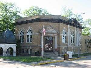
The Monticello Carnegie Library | |
| Motto: "Life With A Splash" | |
 Location in the state of Indiana | |
| Coordinates: 40°44′48″N 86°45′55″W / 40.74667°N 86.76528°WCoordinates: 40°44′48″N 86°45′55″W / 40.74667°N 86.76528°W | |
| Country | United States |
| State | Indiana |
| County | White |
| Township | Union |
| Government | |
| • Mayor | Kenneth Houston (D) |
| Area[1] | |
| • Total | 3.69 sq mi (9.56 km2) |
| • Land | 3.47 sq mi (8.99 km2) |
| • Water | 0.22 sq mi (0.57 km2) 5.96% |
| Elevation[2] | 679 ft (207 m) |
| Population (2010)[3] | |
| • Total | 5,378 |
| • Estimate (2012[4]) | 5,342 |
| • Density | 1,549.9/sq mi (598.4/km2) |
| Time zone | EST (UTC-5) |
| • Summer (DST) | EDT (UTC-4) |
| ZIP code | 47960 |
| Area code(s) | 574 |
| FIPS code | 18-50760[5] |
| GNIS feature ID | 439369 |
| Website | http://www.monticelloin.gov |
Monticello (/mɒntɪˈsɛloʊ/)[6] is a city in Union Township, White County, Indiana, United States.[7] The population was 5,378 at the 2010 census. The city is the county seat of White County.[8]
Monticello is known as a tourist destination in north-central Indiana and is home to the Indiana Beach amusement park, Lake Shafer, and Lake Freeman.
Geography
Monticello is located at 40°44′48″N 86°45′55″W / 40.74667°N 86.76528°W (40.746709, -86.765359).[9]
According to the 2010 census, Monticello has a total area of 3.686 square miles (9.55 km2), of which 3.47 square miles (8.99 km2) (or 94.14%) is land and 0.216 square miles (0.56 km2) (or 5.86%) is water.[1]

Demographics
| Historical population | |||
|---|---|---|---|
| Census | Pop. | %± | |
| 1860 | 565 | — | |
| 1870 | 887 | 57.0% | |
| 1880 | 1,193 | 34.5% | |
| 1890 | 1,518 | 27.2% | |
| 1900 | 2,107 | 38.8% | |
| 1910 | 2,168 | 2.9% | |
| 1920 | 2,536 | 17.0% | |
| 1930 | 2,331 | −8.1% | |
| 1940 | 3,153 | 35.3% | |
| 1950 | 3,467 | 10.0% | |
| 1960 | 4,035 | 16.4% | |
| 1970 | 4,869 | 20.7% | |
| 1980 | 5,162 | 6.0% | |
| 1990 | 5,237 | 1.5% | |
| 2000 | 5,723 | 9.3% | |
| 2010 | 5,378 | −6.0% | |
| Est. 2015 | 5,322 | [10] | −1.0% |
2010 census
As of the census[3] of 2010, there were 5,378 people, 2,179 households, and 1,319 families residing in the city. The population density was 1,549.9 inhabitants per square mile (598.4/km2). There were 2,457 housing units at an average density of 708.1 per square mile (273.4/km2). The racial makeup of the city was 90.8% White or European American, 0.4% African American, 0.4% Native American, 0.8% Asian, 5.5% from other races, and 2.1% from two or more races. Hispanic or Latino of any race were 12.5% of the population.
There were 2,179 households of which 31.1% had children under the age of 18 living with them, 42.6% were married couples living together, 13.1% had a female householder with no husband present, 4.9% had a male householder with no wife present, and 39.5% were non-families. 34.6% of all households were made up of individuals and 18.1% had someone living alone who was 65 years of age or older. The average household size was 2.33 and the average family size was 2.99.
The median age in the city was 40.4 years. 24% of residents were under the age of 18; 8.1% were between the ages of 18 and 24; 23.1% were from 25 to 44; 23.6% were from 45 to 64; and 21.1% were 65 years of age or older. The gender makeup of the city was 47.3% male and 52.7% female.
2000 census
As of the census[5] of 2000, there were 5,723 people, 2,268 households, and 1,417 families residing in the city. The population density was 2,047.9 people per square mile (792.0/km²). There were 2,414 housing units at an average density of 863.8 per square mile (334.1/km²). The racial makeup of the city was 91.39% White, 0.28% African American, 0.31% Native American, 0.59% Asian, 0.07% Pacific Islander, 5.96% from other races, and 1.40% from two or more races. Hispanic or Latino of any race were 11.22% of the population.
There were 2,268 households out of which 29.1% had children under the age of 18 living with them, 48.2% were married couples living together, 10.7% had a female householder with no husband present, and 37.5% were non-families. 32.2% of all households were made up of individuals and 16.5% had someone living alone who was 65 years of age or older. The average household size was 2.40 and the average family size was 3.04.
In the city the population was spread out with 24.3% under the age of 18, 9.3% from 18 to 24, 26.4% from 25 to 44, 21.1% from 45 to 64, and 18.9% who were 65 years of age or older. The median age was 38 years. For every 100 females there were 91.0 males. For every 100 females age 18 and over, there were 83.5 males.
The median income for a household in the city was $35,537, and the median income for a family was $42,831. Males had a median income of $30,478 versus $19,511 for females. The per capita income for the city was $17,066. About 4.8% of families and 8.1% of the population were below the poverty line, including 8.3% of those under age 18 and 9.7% of those age 65 or over.
History
Monticello was laid out in 1834 as the county seat,[12] with a post office established that year, and is still currently in operation.[13] The city was named after President Thomas Jefferson's estate in Virginia.[14]
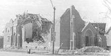
Monticello, Indiana sustained serious damage by a tornado on April 3, 1974, part of the 1974 Super Outbreak that caused death and destruction across the midwest and south.[15] The aftermath of this storm is recorded in the Herald Journal's book, Killer Tornado. The tornado was classified as an F4 on the Fujita scale. This storm killed eight people and was part of tornado family that killed 18, causing an estimated $100 million in damage.[15] In the immediate aftermath of the storm, news outlets reported three hundred deaths across the United States and the creation of temporary morgues.[16] The local paper said the aftermath was similar to a World War II bombing.
On September 2, 2005, Jordan Manufacturing burned down. The company manufactured outdoor furniture such as folding chairs, umbrellas, and seat cushions. Due to the materials used in making these products, four city blocks were contaminated with toxins. The blaze was large enough to require firefighters from seven surrounding communities to battle it and needed approximately "3000 gallons of water per minute for the first three hours of the blaze."[17] While such a fire might not be a big event for a larger city, it had a profound impact on Monticello, as Jordan Manufacturing was one of the few manufacturing plants left in the city after a recession in the 2000s.
The Monticello Carnegie Library, James Culbertson Reynolds House, and South Grade School Building are listed on the National Register of Historic Places.[18][19]
Twin Lakes School Corporation
Twin Lakes School Corporation is the school system in Monticello. The Schools are Eastlawn (elementary), Oaklawn (elementary), Meadowlawn (elementary), Roosevelt Middle School, and Twin Lakes High School. Woodlawn Elementary School was previously part of the district until it was closed in 2013.[20]
The High School was heavily damaged by the 1974 tornado and had to be rebuilt. Students resumed classes in local churches and then in portable units erected near the location of the high school until reconstruction could be completed.
Tourism
Monticello's location between Lakes Shafer and Freeman and the proximity of Indiana Beach allow for a thriving tourism industry that plays a significant role in the city's economy. Although recreational options are geared primarily towards summer activities, the lakes are used throughout the year for fishing. Golfing and boating are available as three season sports. Additionally, Monticello has areas for cross country skiing, snowmobiling and ice skating in the winter.
Entertainment
Monticello is home to one of the few surviving drive-in movie theaters in Indiana, the Lake Shore Drive-In. It has two movie screens playing (in total) 4 movies a night during the spring and summer months in Monticello. On Sunday mornings, a Methodist church service is offered.
The lakes and campgrounds are popular tourist destinations, but the most well-known is Indiana Beach, an amusement park on Lake Shafer.
The Madam Carroll, docked on Lake Freeman, offers scenic lake cruises with live entertainment. Dinner cruises are also held on certain dates.[21]
Notable people
- W. E. Biederwolf (1867-1939), Presbyterian evangelist; buried in Old Monticello Cemetery
- DJ Ashba (born 1972), rock musician
- Gregory Wasson (born 1958), president and CEO of Walgreens
References
- 1 2 "G001 - Geographic Identifiers - 2010 Census Summary File 1". United States Census Bureau. Retrieved 2015-07-29.
- ↑ "US Board on Geographic Names". United States Geological Survey. October 25, 2007. Retrieved 2016-07-06.
- 1 2 "American FactFinder". United States Census Bureau. Retrieved 2012-12-11.
- ↑ "Population Estimates". United States Census Bureau. Retrieved 2013-06-25.
- 1 2 "American FactFinder". United States Census Bureau. Retrieved 2008-01-31.
- ↑ "Indiana Beach amusement park bought by California company". Washington Times (Associated Press). 3 September 2015. Retrieved 4 September 2015.
California-based Apex Parks Group is taking over the park along Lake Shafer near Monticello (mahn-tuh-SEL’-oh) in northwestern Indiana.
- ↑ "Monticello, Indiana". Geographic Names Information System. United States Geological Survey. Retrieved 2016-07-06.
- ↑ "Find a County". National Association of Counties. Retrieved 2011-06-07.
- ↑ "US Gazetteer files: 2010, 2000, and 1990". United States Census Bureau. 2011-02-12. Retrieved 2011-04-23.
- ↑ "Annual Estimates of the Resident Population for Incorporated Places: April 1, 2010 to July 1, 2015". Retrieved July 2, 2016.
- ↑ "Census of Population and Housing". Census.gov. Retrieved June 4, 2015.
- ↑ Hamelle, W. H. (1915). A Standard History of White County, Indiana: An Authentic Narrative of the Past, with an Extended Survey of Modern Developments in the Progress of Town and Country. Unigraphic. p. 289.
- ↑ "White County". Jim Forte Postal History. Retrieved 6 July 2016.
- ↑ "Profile for Monticello, IN". ePodunk. Retrieved 6 July 2016.
- 1 2 Northern Indiana Office. "The Monticello Tornado". National Weather Service. Retrieved 2010-07-12.
- ↑ "'I'll never forget,' DHJ reader says of April 3, 1974". Monticello Daily Herald-Journal, 3 April 1975 supplement, 30.
- ↑ Herald Journal Weekend Edition of September 3–4-5, 2005
- ↑ National Park Service (2010-07-09). "National Register Information System". National Register of Historic Places. National Park Service.
- ↑ "National Register of Historic Places Listings". Weekly List of Actions Taken on Properties: 6/24/13 through 6/28/13. National Park Service. 2013-07-05.
- ↑ http://www.newsbug.info/monticello_herald_journal/news/local/article_7d1c9688-7589-11e2-8087-001a4bcf887a.html
- ↑ http://www.madamcarroll.com
External links
- City of Monticello, Indiana website
- Monticello Chamber of Commerce
- The Herald Journal, Monticello's Newspaper
Municipalities and communities of White County, Indiana, United States | ||
|---|---|---|
| City | ||
| Towns | ||
| Townships | ||
| CDPs | ||
| Other unincorporated communities | ||