Muncie, Indiana
| Muncie, Indiana | |
|---|---|
| City | |
|
Muncie City Hall in 2006. | |
| Nickname(s): Middletown,[1] Little Chicago[2][3][4] | |
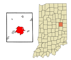 Location in the state of Indiana | |
| Coordinates: 40°11′36″N 85°23′17″W / 40.19333°N 85.38806°WCoordinates: 40°11′36″N 85°23′17″W / 40.19333°N 85.38806°W | |
| Country | United States |
| State | Indiana |
| County | Delaware |
| Township | Center, Hamilton, Liberty, Mount Pleasant |
| Government | |
| • Mayor | Dennis Tyler (D) |
| Area[5] | |
| • Total | 27.39 sq mi (70.94 km2) |
| • Land | 27.20 sq mi (70.45 km2) |
| • Water | 0.19 sq mi (0.49 km2) |
| Elevation | 932 ft (284 m) |
| Population (2010)[6] | |
| • Total | 70,085 |
| • Estimate (2015[7]) | 70,087 |
| • Density | 2,576.7/sq mi (994.9/km2) |
| • Demonym | Munsonian |
| Time zone | EST (UTC−5) |
| • Summer (DST) | EDT (UTC−4) |
| ZIP codes | 47302-47308 |
| Area code | 765 |
| FIPS code | 18-51876[8] |
| GNIS feature ID | 0439878[9] |
| Interstate highways |
|
| U.S. Highways | |
| Major state roads | |
| Waterways | West Fork of White River |
| Airports | Delaware County Regional Airport |
| Public transit | MITS |
| Website | www.cityofmuncie.com |

Muncie /ˈmʌnsi/ is an incorporated city and the seat of Delaware County, Indiana. It is located in east-central Indiana, about 50 miles (80 km) northeast of Indianapolis.[10] The United States Census for 2010 reported the city's population was 70,085. It is the principal city of the Muncie metropolitan statistical area, which has a population of 117,671.[11]
The Lenape (Delaware) people, people, who arrived in the area in the 1790s, founded several small villages, including one known as Munsee Town, along the White River. The small trading post, renamed Muncietown, was selected as the Delaware County seat and platted in 1827. Its name was officially shortened to Muncie in 1845 and incorporated as a city in 1865. Muncie developed as a manufacturing and industrial center, especially after the Indiana gas boom of the 1880s. It is home to Ball State University. As a result of the Middletown studies, sociological research that was first conducted in the 1920s, Muncie is said to be one of the most studied United States cities of its size.[12]
History
Early settlement
The area was first settled in the 1790s by the Lenape (Delaware) people, who migrated west from their tribal lands in the Mid-Atlantic region (all of New Jersey, southeastern New York, eastern Pennsylvania, and northern Delaware) to new lands in present-day Ohio and eastern Indiana. The Lenape founded several towns along the White River, including Munsee Town,[13] near the site of present-day Muncie.
Contrary to popular legend, the city's early name of Munsee Town is derived from the "Munsee" clan of Lenape people, the white settlers' name for a group of Native Americans whose village was once situated along the White River. There is no evidence that a mythological Chief Munsee ever existed.[14] ("Munsee" means a member of or one of their languages.)
In 1818 the area's native tribes ceded their lands to the federal government under the terms of the Treaty of St. Mary's and agreed to move farther west by 1821. New settlers began to arrive in what became Delaware County, Indiana, about 1820, shortly before the area's public lands were formally opened for purchase. The small trading village of Munsee Town, renamed Muncietown, was selected as the Delaware County seat and platted in 1827.[15] On January 13, 1845, Indiana's governor signed legislation passed by the Indiana General Assembly to shorten the town's name to Muncie. Soon, a network of roads connected Muncie to nearby towns, adjacent counties, and to other parts of Indiana. The Indianapolis and Bellefontaine Railroad, the first to arrive in Muncie in 1852, provided the town and the surrounding area with access to larger markets for its agricultural production, as well as a faster means of transporting people and goods into and out of the area.[16][17]
Muncie incorporated as a town on December 6, 1854, and became an incorporated city in 1865.[18][19] John Brady was elected as the city's first mayor. Muncie's early utility companies also date to the mid-1860s, including the city's waterworks, which was established in 1865.[20]
After the American Civil War, two factors helped Muncie attract new commercial and industrial development: the arrival of additional railroads from the late 1890s to the early 1900s and the discovery of abundant supplies of natural gas in the area.[21] Prior to the discovery of nearby natural-gas wells and the beginning of the gas boom in Muncie in 1886, the region was primarily an agricultural area, with Muncie serving as the commercial trading center for local farmers.[22]
Industrial and civic development
.jpg)
The Indiana gas boom of the 1880s ushered in a new era of prosperity to Muncie. Abundant supplies of natural gas attracted new businesses, industries, and additional residents to the city.[23] Although agriculture continued to be an economic factor in the region, industry dominated the city's development for the next 100 years.[21] One of the major manufacturers that arrived early in the city's gas-boom period was the Ball Brothers Glass Manufacturing Company, which was named the Ball Corporation in 1969. The Ball brothers, who were searching for a new site for their glass manufacturing business that was closer to an abundant natural-gas supply, built a new glass-making foundry from in Muncie, beginning its glass production on March 1, 1888. In 1889 the company relocated its metal manufacturing operations to Muncie.[24][25]
In addition to several other glass factories, Muncie attracted iron and steel mills, including the Republic Iron and Steel Company and the Midland Steel Company. (Midland became Inland Steel Company and later moved to Gary, Indiana.) Indiana Bridge Company was also a major employer.[26] By the time the natural gas supply from the Trenton Gas Field had significantly declined and the gas boom ended in Indiana around 1910, Muncie was well established as an industrial town and a commercial center for east-central Indiana, especially with several railroad lines connecting it to larger cities and the arrival of automobile industry manufacturing after 1900.[27][28]
Numerous civic developments also occurred as a result of the city's growth during the 1870s, 1880s, and 1890s, when Muncie citizens built a new city hall, a new public library, and a new high school. The city's gasworks also began operations in the late 1870s.[21] The Muncie Star was founded in 1899 and the Muncie Evening Press was founded in 1905.[15][29] A new public library, which was a Carnegie library project, was dedicated on January 1, 1904, and served as the main branch of the city's public library system.[30]
The forerunner to Ball State University also arrived in the early twentieth century. Eastern Indiana Normal School opened 1899, but it closed after two years. Several subsequent efforts to establish a private college in Muncie during the late nineteenth and early twentieth centuries also failed, but one proved to be very successful. After the Ball brothers bought the school property and its vacant buildings and donated them to the State of Indiana, the Indiana State Normal School, Eastern Division, the forerunner to Ball State University, opened in 1918. It was named Ball Teachers College in 1922, Ball State Teachers College in 1929, and Ball State University in 1965.[28][31][32]
Beginning in the late nineteenth century, in tandem with the gas boom, Muncie developed an active cultural arts community, which included music and art clubs, women's clubs, self-improvements clubs, and other social clubs. Hoosier artist J. Ottis Adams, who came to Muncie in 1876, later formed an art school in the city with fellow artist, William Forsyth. Although their school closed with a year or two, other art groups were established, most notably the Art Students' League (1892) and the Muncie Art Association (1905).[33]
By the early twentieth century several railroads served Muncie, which helped to establish the city as a transportation hub. The Cincinnati, Richmond and Muncie Railroad (later known as the Chesapeake and Ohio Railway) reached Muncie in 1903. The Chicago, Indiana, and Eastern Railroad (acquired by a subsidiary of the Pennsylvania Railroad system) and the Chicago and Southeastern (sometimes called the Central Indiana Railroad) also served the city. In addition to the railroads, Muncie's roads connected to nearby towns and an electric interurban system, which arrived in the early 1900s, linked it to smaller towns and larger cities, such as Indianapolis and Fort Wayne, Indiana, and Dayton, Ohio.[34]
With the arrival of the auto manufacturing and the related auto parts industry after the turn of the twentieth century, Muncie's industrial and commercial development increased, along with its population growth. During World War I local manufacturers joined others around the county in convering their factories to production of war materiel.[35] In the 1920s Muncie continued its rise as an automobile-manufacturing center, primarily due to its heavy industry and skilled labor force. During this time, the community also became a center of Ku Klux Klan activity. Muncie's Klan membership was estimated at 3,500 in the early 1920s. Scandals within the Klan's leadership, divisions among its members, and some violent confrontations with their opponents damaged the organization's reputation. Increasing hostility toward the Klan's political activities, beliefs, and values also divided the Muncie community, before its popularity and membership significantly declined by the end of the decade.[36]
Muncie residents also made it through the challenges of the Great Depression, with the Ball brothers continuing their role as major benefactors to the community by donating funds for construction of new facilities at Ball State and Ball Memorial Hospital.[37] (The hospital, which opened in 1929, later affiliated with Indiana University Health.[38]) The Works Progress Administration (WPA) also provided jobs such as road grading, city sewer improvements, and bridge construction.[37]
Middletown studies
In the 1920s Robert and Helen Lynd led a team of sociologists in a study of a typical middle-American community. The Lynds chose Muncie as the locale for their field research, although they never specifically identified it as "Middletown" the fictional name of the town in their study. Muncie received national attention after the publication of their book, Middletown: A Study in Contemporary American Culture (1929). The Lynds returned to Muncie to re-observe the community during the Depression, which resulted in a sequel, Middletown in Transition: A Study in Cultural Conflicts (1937).[39] The Lynds' Middletown study, which was funded by the Rockefeller Institute of Social and Religious Research, was intended to study "the interwoven trends that are the life of a small American city."[40]
The Lynds were only the first to conduct a series of studies in Muncie. The National Science Foundation funded a third major study that resulted in two books by Theodore Caplow, Middletown Families (1982) and All Faithful People (1983). Caplow returned to Muncie in 1998 to begin another study, Middletown IV, which became part of a Public Broadcasting Service documentary titled "The First Measured Century", released in December 2000. The Ball State Center for Middletown Studies continues to survey and analyze social change in Muncie.[41] A database of Middletown surveys conducted between 1978 and 1997 is available online from the Association of Religion Data Archives (ARDA).[42] Due to the extensive information collected from the Middletown studies during the twentieth century, Muncie is said to be one of the most studied cities of its size in the United States.[43]
In addition to being called a "typical American city", as the result of the Middletown studies, Muncie is known as Magic City or Magic Muncie, as well as the Friendly City.[44]
World War II to the present

During World War II the city's manufacturers once again turned their efforts to wartime production. Ball State and Muncie's airport also trained pilots for the U.S. Navy.[37] The postwar era was another period of expansion for Muncie, with continued growth and development of industries, construction of new homes, schools, and businesses. A population boom brought further development, especially from 1946 to 1965.[15]
Since the 1950s and 1960s Muncie has continued as an education center in the state and emerged as a regional health center. As enrollment at Ball State increased, new buildings were erected on the college's campus. Ball Memorial Hospital also expanded its facilities.[45] However, by the 1960s, industrial trends had shifted. Beginning in the 1970s several manufacturing plants closed or moved elsewhere, while others adapted to industrial changes and remained in Muncie. Ball Corporation, for example, closed its Muncie glass manufacturing facilities in 1962; its corporate headquarters relocated to Broomfield, Colorado in 1998.[46][47] Muncie was also home to other manufacturing operations, including Warner Gear (a division of BorgWarner), Delco Remy, General Motors, Ontario Corporation, A. E. Boyce Company, and Westinghouse Electric, among others.[48]
Geography
.jpg)
According to the 2010 census, Muncie has a total area of 27.392 square miles (70.94 km2), of which 27.2 square miles (70.45 km2) (or 99.3%) is land and 0.192 square miles (0.50 km2) (or 0.7%) is water.[5]
Climate

Muncie has a humid continental climate (Köppen climate classification Dfa) experiencing four distinct seasons.
| Climate data for Muncie, Indiana | |||||||||||||
|---|---|---|---|---|---|---|---|---|---|---|---|---|---|
| Month | Jan | Feb | Mar | Apr | May | Jun | Jul | Aug | Sep | Oct | Nov | Dec | Year |
| Record high °F (°C) | 65 (18) |
74 (23) |
80 (27) |
88 (31) |
93 (34) |
106 (41) |
101 (38) |
99 (37) |
96 (36) |
90 (32) |
79 (26) |
71 (22) |
106 (41) |
| Average high °F (°C) | 34 (1) |
38 (3) |
49 (9) |
62 (17) |
72 (22) |
81 (27) |
85 (29) |
83 (28) |
77 (25) |
64 (18) |
51 (11) |
38 (3) |
60 (16) |
| Average low °F (°C) | 19 (−7) |
22 (−6) |
30 (−1) |
41 (5) |
52 (11) |
62 (17) |
64 (18) |
62 (17) |
54 (12) |
43 (6) |
34 (1) |
24 (−4) |
41 (5) |
| Record low °F (°C) | −29 (−34) |
−13 (−25) |
−8 (−22) |
10 (−12) |
25 (−4) |
36 (2) |
40 (4) |
39 (4) |
27 (−3) |
18 (−8) |
3 (−16) |
−21 (−29) |
−29 (−34) |
| Average precipitation inches (mm) | 2.21 (56.1) |
2.39 (60.7) |
3.17 (80.5) |
3.60 (91.4) |
4.51 (114.6) |
4.35 (110.5) |
4.19 (106.4) |
3.21 (81.5) |
3.01 (76.5) |
2.86 (72.6) |
3.45 (87.6) |
3.02 (76.7) |
39.96 (1,015) |
| Average snowfall inches (cm) | 6.2 (15.7) |
4.3 (10.9) |
1.7 (4.3) |
0.1 (0.3) |
0 (0) |
0 (0) |
0 (0) |
0 (0) |
0 (0) |
0.2 (0.5) |
0.4 (1) |
3.8 (9.7) |
16.7 (42.4) |
| Source #1: NOAA[49] | |||||||||||||
| Source #2: Homefacts[50] | |||||||||||||
Demographics
| Historical population | |||
|---|---|---|---|
| Census | Pop. | %± | |
| 1850 | 606 | — | |
| 1860 | 1,782 | 194.1% | |
| 1870 | 2,992 | 67.9% | |
| 1880 | 5,219 | 74.4% | |
| 1890 | 11,345 | 117.4% | |
| 1900 | 20,942 | 84.6% | |
| 1910 | 24,005 | 14.6% | |
| 1920 | 36,524 | 52.2% | |
| 1930 | 46,548 | 27.4% | |
| 1940 | 49,720 | 6.8% | |
| 1950 | 58,479 | 17.6% | |
| 1960 | 68,603 | 17.3% | |
| 1970 | 69,082 | 0.7% | |
| 1980 | 76,460 | 10.7% | |
| 1990 | 71,035 | −7.1% | |
| 2000 | 67,430 | −5.1% | |
| 2010 | 70,085 | 3.9% | |
| Est. 2015 | 70,087 | [51] | 0.0% |
| Estimate[52] | |||
2010 census
As of the census[6] of 2010, there were 70,085 people, 27,722 households, and 13,928 families residing in the city. The population density was 2,576.7 inhabitants per square mile (994.9/km2). There were 31,958 housing units at an average density of 1,174.9 per square mile (453.6/km2). The racial makeup of the city was 84.0% White, 10.9% African American, 0.3% Native American, 1.2% Asian, 0.1% Pacific Islander, 0.8% from other races, and 2.8% from two or more races. Hispanic or Latino of any race were 2.3% of the population.
There were 27,722 households of which 23.9% had children under the age of 18 living with them, 31.5% were married couples living together, 14.1% had a female householder with no husband present, 4.6% had a male householder with no wife present, and 49.8% were non-families. 35.2% of all households were made up of individuals and 10.9% had someone living alone who was 65 years of age or older. The average household size was 2.22 and the average family size was 2.85.
The median age in the city was 28.1 years. 17.8% of residents were under the age of 18; 27.5% were between the ages of 18 and 24; 21.4% were from 25 to 44; 20.2% were from 45 to 64; and 13% were 65 years of age or older. The gender makeup of the city was 47.5% male and 52.5% female.
2000 census
As of the census of 2000,[8] there were 67,430 people, 27,322 households, and 14,589 families residing in the city. The population density was 2,788.2 people per square mile (1,076.7/km²). There were 30,205 housing units at an average density of 1,248.9 per square mile (482.3/km²). The racial makeup of the city was 83.72% White, 12.97% African American, 0.27% Native American, 0.79% Asian, 0.09% Pacific Islander, 0.67% from other races, and 1.49% from two or more races. Hispanic or Latino of any race were 1.44% of the population.
There were 27,322 households out of which 23.7% had children under the age of 18 living with them, 36.4% were married couples living together, 13.0% had a female householder with no husband present, and 46.6% were non-families. 34.1% of all households were made up of individuals and 11.8% had someone living alone who was 65 years of age or older. The average household size was 2.24 and the average family size was 2.86.
In the city the age distribution of the population shows 19.8% under the age of 18, 24.6% from 18 to 24, 24.2% from 25 to 44, 18.3% from 45 to 64, and 13.2% who were 65 years of age or older. The median age was 29 years. For every 100 females there were 89.9 males. For every 100 females age 18 and over, there were 86.5 males.
The median income for a household in the city was $26,613, and the median income for a family was $36,398. Males had a median income of $30,445 versus $21,872 for females. The per capita income for the city was $15,814. About 14.3% of families and 23.1% of the population were below the poverty line, including 24.2% of those under age 18 and 9.7% of those age 65 or over.
Economy

From its early days as a regional trading center for the surrounding agricultural community to its first wave of industrial development brought on by the Indiana gas boom in the mid-1880s, Muncie has retained its ties to an industrial economy, and to a lesser extent its agricultural roots. In addition, the arrival of the forerunner to Ball State in the early twentieth century contributed to Muncie's development as an educational center, while Ball Memorial Hospital, established in 1929, led to the city's reputation as a healthcare center for east-central Indiana.
Muncie's major industrial development included glass manufacturing, iron and steel mills, and automobile manufacturing and auto parts factories. Among its early major employers was the Ball Corporation, established by the Ball brothers of Buffalo, New York, who opened a glass factory in Muncie in 1888.[25] Other notable manufacturers in addition to the Ball Corporation with operations in Muncie have included BorgWarner, The Broderick Company (aformer division of Harsco), Dayton-Walther Corporation, Delco Remy, General Motors, New Venture Gear, Hemingray Glass Company, Ontario Corporation, A. E. Boyce Company, Indiana Steel and Wire, and Westinghouse Electric.[48]
Changing industrial trends caused shifts in the city's economic development. As in many mid-sized cities in the Rust Belt, deindustrialization, which began in the 1960s, impacted Muncie's economy. Several manufacturing plants closed or moved elsewhere. From 2001 to 2011, Muncie lost thousands of jobs[53] as the city continued transitioning from a blue-collar workforce to a white-collar service economy primarily based on health care, education, and retail.[54]
Muncie has attracted some new manufacturers, while older factories have been converted to other industrial uses. In 2009 Muncie became the U.S. headquarters for Brevini Wind, an Italian-based company that manufactures gearboxes for wind turbines.[53][55] In 2011 locomotive maker Progress Rail Services (a subsidiary of Caterpillar Inc.) opened in a former Westinghouse facility that had been vacant since 1998.[55][56]
The local economy is a controversial topic among Munsonians. While many older unemployed or underemployed residents strongly identify with the manufacturing identity of the city, newer residents identify with the city's shift towards educational and health services.[57] Contention is greatest among residents living in the once-industrialized sections of the city's south side, as much of the economic growth over that last few decades has taken place on Muncie's north side.[58][59][60] The city also struggles to retain college graduates. Despite Ball State's presence, only 32.2 percent of Delaware County's working-age adults (ages 25–64) hold a two-year or four-year college degree, which is below the national average.[61]
The first decade of the 21st century saw a cultural shift toward local businesses and economic empowerment, boosted by the Muncie Downtown Development Partnership[62] and the residents, patrons, and business owners of the downtown community. In 2007, Muncie was rated the most affordable college town in America by real estate company Coldwell Banker.[63] In 2015, Forbes ranked Muncie 27th among small places for business and careers and 18th for cost of doing business.[64] First Merchants Corporation is based in Muncie, and the first Scotty's Brewhouse location opened in the city in 1996.[65]
.jpg)
As of May 2016, the largest employers in the city were:[66]
| Rank | Employer | # of employees |
|---|---|---|
| 1 | IU Health Ball Memorial Hospital | 3,000 |
| 2 | Ball State University | 2,800 |
| 3 | Muncie Community Schools | 843 |
| 4 | Navient | 650 |
| 5 | Meridian Services | 610 |
| 6 | Walmart | 597 |
| 7 | Marsh Supermarkets | 592 |
| 8 | Magna Powertrain | 528 |
| 9 | First Merchants Corporation | 516 |
| 10 | Ivy Tech Community College of Indiana | 482 |
Culture


The David Owsley Museum of Art collection, which includes over 11,000 works, has been in the Fine Arts Building on the Ball State University campus since 1935. The Horizon Convention Center, located downtown, offers 47,000 square feet of exhibition space and houses the Muncie Children's Museum.[67] The city also has a large group of independent art galleries.[68]
Three of the city's largest performing arts centers belong to Ball State University: the 3,581-seat Emens Auditorium, the 600-seat Sursa Performance Hall, and the 410-seat University Theatre.[69][70] Downtown performing arts spaces include the Muncie Civic Theatre and Canan Commons, an outdoor amphitheater and greenspace that opened in 2011. In addition, the Muncie Ballet and the Muncie Symphony Orchestra are prominent in the city's arts community.
Minnetrista Cultural Center, just north of downtown along the White River, is a cultural heritage museum featuring exhibits and programs focusing on nature, east-central Indiana history, and art. The 40 acres (16 hectares) campus includes historic homes that were once owned by the Ball family, themed gardens, outdoor sculptures, and a portion of the White River Greenway. The Cardinal Greenway, Indiana's longest rail trail project, stretches 60 miles (97 km) from Richmond to Marion, Indiana. Designated a National Recreation Trail in 2003, it is part of the American Discovery Trail. The Ball State campus is home to Christy Woods, an 18 acres (7.3 hectares) arboretum, three greenhouses, and the Wheeler Orchid Collection and Species Bank.
Muncie's music scene has been home to such acts as Brazil, Everything, Now! and Archer Avenue (ex-Margot & the Nuclear So and So's). Muncie also hosts several local music festivals, including Muncie Gras[71] and Muncie MusicFest.[72] Muncie also has a network of craft beer enthusiasts.[73]
Sports

Muncie is home to the NCAA Division I Ball State Cardinals which is a member of the Mid-American Conference. Notable sports include football (played at Scheumann Stadium), men's basketball (played at John E. Worthen Arena), and baseball (played at Ball Diamond).
Muncie was once home to the Muncie Flyers, also known as the Congerville Flyers, the city's professional football team from 1905 to 1925. The Muncie team was one of the eleven charter members of National Football League (NFL). It played in the league from 1905 to 1925.[74]
Muncie was also home to the Muncie Flyers, a minor league hockey team. The team played in the International Hockey League for a single season in 1948–1949.
Education
Higher education
Elementary schools
- Burris Laboratory School
- East Washington Academy
- Grissom Elementary
- Heritage Hall Christian School
- Hoosier Academy Muncie
- Longfellow Elementary
- Mitchell Elementary
- North View Elementary
- South View Elementary
- Storer Elementary
- St. Lawrence Elementary School
- St. Mary Elementary School
- Sutton Elementary
- West View Elementary
Middle schools
- Burris Laboratory School
- Heritage Hall Christian School
- Hoosier Academy Muncie
- Northside Middle School
- Pope John Paul II Middle School
- Southside Middle School
High schools
- Burris Laboratory School
- Delta High School
- Heritage Hall Christian School
- Indiana Academy for Science, Mathematics, and Humanities
- Muncie Area Career Center
- Muncie Central High School
Libraries

- Carnegie Library
- Kennedy Library
- Maring–Hunt Library
- Connection Corner
- Bracken Library (Ball State)
Media
Newspapers
Television
As part of the Indianapolis market, Muncie receives Indianapolis' network affiliates. East Central Indiana's PBS member station, WIPB, is located in Muncie.
Radio stations
Transportation
Air
- Delaware County Regional Airport (not a commercial airport)
- Fort Wayne International Airport at 74.4 miles (119.7 km) and Indianapolis International Airport at 75.4 miles (121.3 km) are the nearest commercial airports.
Highways
Rail
Mass transit
Muncie Indiana Transit System (MITS) provides 14 fixed bus routes daily, except Sundays.[75]
Sister city
-
 Zhuji City, Zhejiang Province, People's Republic of China (since 2010)[76]
Notable natives and residents
Note: This list does not include Ball State University graduates. Please see List of Ball State University alumni for notable alumni.
General
- Ball Brothers, industrialists and philanthropists, founders of the Ball Corporation
- Benjamin Victor Cohen, key figure in the administrations of Presidents Franklin D. Roosevelt and Harry S. Truman
- George R. Dale, editor of Muncie Post-Democrat (1920–1936), gained national attention speaking out against the Ku Klux Klan[77]
- Bertha Fry, supercentarian, third oldest person on earth at time of death, November 14, 2007 (113 years)[78]
- Gregory H. Williams, Lawyer and Author of Life on the Color Line: The True Story of a White Boy Who Discovered He Was Black; 27th President of the University of Cincinnati, and the 11th President of the City College of New York
Arts
- Wayman Elbridge Adams, painter known for his rapid approach to stylized portraiture works
- J. Ottis Adams, Hoosier Group artist[79]
- Ray Boltz, Contemporary Christian musical artist[80]
- Angelin Chang, Grammy Award-winning classical pianist
- Trevor Chowning, pop artist and former Hollywood talent agent/producer
- Mary Jane Croft, actress
- Jim Davis, cartoonist, creator of the Garfield comic strip[81][82]
- Emily Kimbrough, author and magazine editor, Our Hearts Were Young and Gay and How Dear to My Heart[83]
Sports
- Cliff Baldwin, football player
- Ron Bonham, former All-American Muncie Central basketball standout, Cincinnati Bearcats, Indiana Pacers, and NBA champion Boston Celtics
- Buck Crouse, professional baseball player for Chicago White Sox
- Bill Dinwiddie, professional basketball player
- Dave Duerson, All-American defensive back for Notre Dame; played 11 seasons for NFL's Chicago Bears, New York Giants, and Phoenix Cardinals[84]
- Hod Eller, professional baseball player for 1919 World Series champion Cincinnati Reds
- Brandon Gorin, professional football player, New England Patriots, Arizona Cardinals, St. Louis Rams, and Denver Broncos[85]
- Ryan Kerrigan, Purdue University football standout, professional football player with Washington Redskins
- Richie Lewis, professional baseball player, Baltimore Orioles, Florida Marlins, Detroit Tigers, Oakland Athletics, and Cincinnati Reds
- Adam Lind, professional baseball player, Seattle Mariners
- Matt Painter, Purdue University men's basketball head coach[86]
- John Paul, Jr., Indy Car driver
- Jamill Smith, professional football player
- Frank Thomas, Notre Dame quarterback and roommate of George "The Gipper" Gipp; head football coach of University of Alabama 1931-46, won two national championships
- Bonzi Wells, former Muncie Central High School and Ball State University standout, professional basketball player, Houston Rockets, Memphis Grizzlies, New Orleans Hornets, Portland Trail Blazers, and Sacramento Kings; currently plays for the Puerto Rican team Capitanes de Arecibo[87]
See also
- Academy of Model Aeronautics
- Armed & Famous
- List of public art in Muncie, Indiana
- Muncie Mall
- Muncie SM465 transmission
References
- ↑ Huppke, Rex (April 27, 2003). "Day of prayer turning into day of discord". Chicago Tribune. Chicago. Retrieved November 7, 2016.
- ↑ Roysdon, Keith; Walker, Douglas (2016). Wicked Muncie. The History Press. ISBN 978-1-43965-665-5.
- ↑ Lasley, Norma (2012). "Muncie". Delaware County. Arcadia Publishing. p. 57. ISBN 978-0-7385-9430-9.
- ↑ Younge, Gary (November 11, 2016). "How Trump took middle America". The Guardian. London. Retrieved November 16, 2016.
- 1 2 "G001 – Geographic Identifiers – 2010 Census Summary File 1". United States Census Bureau. Retrieved 2015-07-29.
- 1 2 "American FactFinder". United States Census Bureau. Retrieved 2012-12-11.
- ↑ "Population Estimates". United States Census Bureau. Retrieved 2016-06-23.
- 1 2 "American FactFinder". United States Census Bureau. Archived from the original on 2013-09-11. Retrieved 2008-01-31.
- ↑ "US Board on Geographic Names". United States Geological Survey. 2007-10-25. Retrieved 2008-01-31.
- ↑ "Indianapolis, Indiana to Muncie, Indiana". Google. Retrieved 2015-06-25.
- ↑ "Delaware County QuickFacts". United States Census Bureau. Retrieved 2011-09-17.
- ↑ "Center for Middletown Studies". Ball State University. Retrieved 2013-07-17.
- ↑ According to an historical map of "The Indians" by Clark Ray.
- ↑ Richard A. Greene (1965). Muncie and Delaware County: An Historical Sketch. Muncie, Indiana: Delaware County Historical Society. p. 15.
- 1 2 3 Greene, pp. 15–16.
- ↑ Greene, pp. 7–8.
- ↑ Wiley W. Spurgeon & H. Duane Harrison (1984). Muncie and Delaware County: An Illustrated Retrospective. Woodland Hills, California: Windsor Publications. pp. 23–24. ISBN 0897811046.
- ↑ Greene, pp. 7–6 and 15–16.
- ↑ William Harrison Kemper (1908). A Twentieth Century History of Delaware County, Indiana. Lewis Publishing Company. p. 113.
- ↑ Greene, pp. 9, 13.
- 1 2 3 Spurgeon, p. 27.
- ↑ Muncie of To-Day: Its Commerce, Trade and Industries, Descriptive and Historical (reprint ed.). Mt. Vernon, Indiana: Windmill Publications. 1999. p. 5. OCLC 41400603.
- ↑ Greene, p. 10.
- ↑ Dwight W. Hoover (1980). A pictorial history of Indiana. Indiana University Press. ISBN 9780253146939.
- 1 2 Barbara Quigley, "The Ball Brothers" in Gugin, Linda C., and James E. St. Clair, eds. (2015). Indiana's 200: The People Who Shaped the Hoosier State. Indianapolis: Indiana Historical Society Press. p. 14. ISBN 978-0-87195-387-2.
- ↑ Spurgeon, p. 38.
- ↑ Spurgeon, p. 41.
- 1 2 Greene, p. 11.
- ↑ By the mid-1940s the two newspapers were under common ownership. See Spurgeon, p. 47.
- ↑ Spurgeon, p. 50.
- ↑ "Ball State University: History and Mission". Ball State University. Retrieved 2012-11-06.
- ↑ Frank D. Haimbaugh, ed. (1924). History of Delaware County Indiana. 1. Indianapolis: Historical Publishing Company. pp. 334–35. OCLC 7224336.
- ↑ Ned H. Griner (1985). Side By Side With Coarser Plants: The Muncie Art Movement, 1885–1985. Muncie, Indiana: Ball State University. pp. 6–9, 13–14, 23, 37. OCLC 13211261.
- ↑ Spurgeon, pp. 46–47.
- ↑ Spurgeon, pp. 50, 55.
- ↑ Dwight W. Hoover (1986). Magic Middletown. Bloomington: Indiana University Press. pp. 96–100. ISBN 9780253285904.
- 1 2 3 Spurgeon, p. 63.
- ↑ Quigley, p. 16.
- ↑ Spurgeon, p. 58.
- ↑ Robert S. Lynd & Helen M. Lynd (1929). Middletown, A Study in Contemporary American Culture. Harcourt, Brace and Company. p. 3. OCLC 885209.
- ↑ "Center for Middletown Studies". Ball State University. Retrieved 2016-04-06.
- ↑ "Online Tools". Association of Religious Data Archives. Retrieved 2016-04-06.
- ↑ "Center for Middletown Studies". Ball State University. Retrieved 2013-07-17.
- ↑ Greene, pp. 14–15.
- ↑ Spurgeon, pp. 82, 92–94, 114–15.
- ↑ Spurgeon, p. 71.
- ↑ Quigley, pp. 14–15.
- 1 2 Spurgeon, pp. 90–98, 103, 110–14, 128–29.
- ↑ "National Weather Service Climate". NOWdata. June 2014.
- ↑ "Muncie, Indiana Climate Information and Data". Homefacts.com. July 2013.
- ↑ "Annual Estimates of the Resident Population for Incorporated Places: April 1, 2010 to July 1, 2015". Retrieved July 2, 2016.
- ↑ "American FactFinder". U.S. Census Bureau. Retrieved 2015-02-18.
- 1 2 Paul Davidson (2011-05-09). "Two Indiana cities symbolize both sides of uneven jobs recovery". USA Today. Retrieved 2013-07-17.
- ↑ "Muncie IN". Forbes. 2012. Retrieved 2013-07-13.
- 1 2 Hagerty, James (2012-03-18). "As Unions Lose Their Grip, Indiana Lures Manufacturing Jobs". The Wall Street Journal. Archived from the original on July 1, 2014. Retrieved 2013-07-17.
- ↑ "Progress Rail Announces Grand Opening of Muncie, Indiana Locomotive Assembly Operation". PR Newswire. 2011. Retrieved 2013-07-17.
- ↑ Robin Gibson (3 May 2014). "LOST MUNCIE: Current, former Muncie residents revisit the past online". The Star Press. Retrieved 4 May 2014.
- ↑ Mary Williams Walsh (2000-04-19). "'New economy' deepens the wealth divide". Los Angeles Times. Retrieved 2015-06-25.
- ↑ "Muncie Mayor Election: The final vote". Muncie Free Press. 2011-11-06. Archived from the original on May 4, 2014. Retrieved 2013-07-14.
- ↑ Ron Fournier (2012-04-19). "In Nothing We Trust". National Journal. Retrieved 2013-07-13.
- ↑ Seth Slabaugh (2 May 2014). "Where have all the college grads gone?". The Star Press. Retrieved 4 May 2014.
- ↑ "MDDP Accomplishments & Awards". MDDP. 2012. Retrieved 2014-05-04.
- ↑ "Muncie Tops Most Affordable College Town List". Inside Indiana Business. 2007-11-06. Retrieved 2013-07-17.
- ↑ "Best Small Places For Businesses and Careers List". Forbes. Retrieved April 17, 2016.
- ↑ Roysdon, Keith. "Scotty: 'Really excited' for Muncie restaurants". Dine and Dash. The Star Press. Retrieved April 17, 2016.
- ↑ "Major Employers". Muncie–Delaware County Economic Development Alliance. 2016. Retrieved May 25, 2016.
- ↑ "About Us". Horizon Convention Center. Retrieved 2015-04-07.
- ↑ "Muncie Indiana Center Visitors Bureau". Muncie Visitors Bureau. Archived from the original on May 5, 2014. Retrieved 2014-05-04.
- ↑ "About Emens". Ball State University. Retrieved 2013-07-14.
- ↑ "Sursa Performance Hall". Ball State University. Retrieved 2013-07-14.
- ↑ "Downtown Muncie, Muncie Gras". MDDP. Retrieved 2014-05-04.
- ↑ "Muncie MusicFest". Muncie MusicFest. Retrieved 2014-05-04.
- ↑ "TURNING A CORNER: Sean Brady's brewery up and running". The Star Press. Retrieved 2014-05-04.
- ↑ "History of the Muncie Flyers Football team". Retrieved 2012-08-25.
- ↑ Muncie Indiana Transit System. "Routes & Schedules". MITS. Retrieved 2015-06-25.
- ↑ "Chicago Ceremony Links Muncie – Zhuji City". Muncie–Delaware County, Indiana Economic Development Alliance. Retrieved 2013-07-12.
- ↑ "The Life and Times of George Dale, Muncie Mayor and Editor". Ball State University. Retrieved 2012-08-25.
- ↑ "Bertha Fry, World's 3rd Oldest Person, Dies in Muncie". Retrieved 2012-08-25.
- ↑ Griner, pp. 7–9 and 13–14.
- ↑ Ray Boltz
- ↑ The Official Website of Garfield and Friends
- ↑ Jim Davis :: Profile
- ↑ Emily Kimbrough
- ↑ Dave Duerson Past Stats, Statistics, History, and Awards – databaseFootball.com
- ↑ Brandon Gorin | NFL Football at CBSSports.com
- ↑ Player Bio: Matt Painter :: Men's Basketball
- ↑ Bonzi Wells Statistics – Basketball-Reference.com
External links
| Wikimedia Commons has media related to Muncie, Indiana. |
- City of Muncie, Indiana website
- Muncie Visitors Bureau
- Muncie Chamber of Commerce
-
 Muncie, Indiana travel guide from Wikivoyage
 -
 Chisholm, Hugh, ed. (1911). "Muncie". Encyclopædia Britannica (11th ed.). Cambridge University Press.
 - LIFE Magazine May 10, 1937, "Middletown-Muncie", pages 15–25, ("the Picture Essay"), at Google Books.
- Digitized archival collections related to Muncie and its history (Ball State University Digital Media Repository)
Municipalities and communities of Delaware County, Indiana, United States | ||
|---|---|---|
| City | ||
| Towns | ||
| Townships | ||
| Unincorporated communities | ||
| Footnotes | ‡This populated place also has portions in an adjacent county or counties | |