Gary, Indiana
| City of Gary | ||
|---|---|---|
| City | ||
|
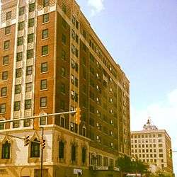
The Genesis Towers (originally the Hotel Gary) and Gary State Bank Building in downtown Gary | ||
| ||
| Nickname(s): City in Motion, City of the Century, GI, Magic City of Steel, The Steel City, City on the Move | ||
| Motto: We Are Doing Great Things | ||
 Gary's location in Lake County (left) and the state of Indiana (right). | ||
| Coordinates: 41°35′44″N 87°20′43″W / 41.59556°N 87.34528°WCoordinates: 41°35′44″N 87°20′43″W / 41.59556°N 87.34528°W[1] | ||
| Country |
| |
| State |
| |
| County | Lake | |
| Townships | Calumet and Hobart | |
| Incorporated | July 14, 1906 | |
| Named for | Elbert Henry Gary | |
| Neighborhoods | ||
| Government[2] | ||
| • Type | Council-Strong Mayor | |
| • Mayor | Karen M. Freeman-Wilson (D) | |
| • City Council | ||
| • City Clerk | Suzette Raggs (D) | |
| • City Judge | Deidre L. Monroe (D) | |
| Area[3] | ||
| • Total | 57.18 sq mi (148.1 km2) | |
| • Land | 49.87 sq mi (129.2 km2) | |
| • Water | 7.31 sq mi (18.9 km2) | |
| Elevation[1] | 607 ft (185 m) | |
| Population (2010)[4] | ||
| • Total | 80,294 | |
| • Estimate (2015) | 77,156 | |
| • Density | 1,610.1/sq mi (621.7/km2) | |
| Standard of living (2008-12)[4] | ||
| • Per capita income | $15,764 | |
| • Median home value | $66,900 | |
| Time zone | Central (UTC−6) | |
| • Summer (DST) | Central (UTC−5) | |
| ZIP codes | 46401-46411 | |
| Area code | 219 | |
| FIPS code | 18-27000 | |
| GNIS feature ID | 2394863[1] | |
| Interstates |
| |
| U.S. Routes |
| |
| State Routes |
| |
| Airport |
| |
| Waterways |
Grand Calumet River | |
| South Shore Line stations |
Adam Benjamin Metro Center | |
| Public transit | Gary Public Transportation Corp. | |
| Website | Official website | |

Gary (/ɡɛəri/) is a city in Lake County, Indiana, United States, 25 miles (40 kilometres) from downtown Chicago, Illinois.
The population of Gary was 80,294 at the 2010 census,[6] making it the ninth-largest city in the state of Indiana. From the middle of the twentieth century to the present, Gary has experienced drastic population loss, falling by 55 percent from its peak of 178,320 in 1960.[7]
Gary is adjacent to the Indiana Dunes National Lakeshore and borders Lake Michigan.[8][9] The city is known for its large steel mills, and for being the birthplace of The Jackson 5 music group.
History
Founding and early years

Gary, Indiana, was founded in 1906 by the United States Steel Corporation as the home for its new plant, Gary Works. The city was named after lawyer Elbert Henry Gary, who was the founding chairman of the United States Steel Corporation.
Gary was the site of civil unrest in the Steel Strike of 1919. On October 4, 1919, a riot broke out on Broadway, the main north-south street through downtown Gary, between striking steel workers and strike breakers brought in from outside. Three days later, Indiana governor James P. Goodrich declared martial law. Shortly thereafter, over 4,000 federal troops under the command of Major General Leonard Wood arrived to restore order.[10]
The jobs offered by the steel industry provided Gary with very rapid growth and a diverse population within the first 26 years of its founding. According to the 1920 United States Census, 29.7% of Gary's population at the time was classified as foreign-born, mostly from eastern European countries, with another 30.8% classified as native-born with at least one foreign-born parent. By the 1930 United States Census, the first census in which Gary's population exceeded 100,000, the city was the fifth largest in Indiana and comparable in size to South Bend, Fort Wayne, and Evansville. At that time, 19.3% of the population was classified as foreign-born, with another 25.9% as native-born with at least one foreign-born parent. Gary was also becoming increasingly racially diverse, with 17.8% of the population classified as black, and 3.5% as Mexican.
Post World War II
.jpg)
Gary's fortunes have risen and fallen with those of the steel industry. The growth of the steel industry brought prosperity to the community. Broadway was known as a commercial center for the region. Department stores and architecturally significant movie houses were built in the downtown area and the Glen Park neighborhood.
In the 1960s, like many other American urban centers reliant on one particular industry, Gary entered a spiral of decline. Gary's decline was brought on by the growing overseas competitiveness in the steel industry, which had caused U.S. Steel to lay off many workers from the Gary area. As the city declined, crime increased.
Rapid racial change occurred in Gary during the late 20th century. These population changes resulted in political change which reflected the racial demographics of Gary. Gary had one of the nation's first African-American mayors, Richard G. Hatcher, and hosted the ground-breaking 1972 National Black Political Convention.[11]
In the 1960s through the 1980s, surrounding suburban localities such as Merrillville and Crown Point experienced rapid growth, including new homes and shopping districts. Owing to white flight, economic distress, and skyrocketing crime, many middle-class and affluent residents moved to other cities in the metro area such as Chicago and surrounding areas in Lake and Porter counties in Indiana.
In the late 1990s and early 2000s, Gary had the highest percentage of African-Americans of U.S. cities with a population of 100,000 or more, 84% (as of the 2000 U.S. census). This no longer applies to Gary since the population of the city has now fallen well below 100,000 residents. As of 2013, the Gary Department of Redevelopment has estimated that one-third of all homes in the city are unoccupied and/or abandoned.[12]
U.S. Steel continues to be a major steel producer, but with only a fraction of its former level of employment. While Gary has failed to reestablish a manufacturing base since its population peak, two casinos opened along the Gary lakeshore in the 1990s, although this has been aggravated by the state closing of Cline Avenue, an important access to the area. Today, Gary faces the difficulties of a rust belt city, including unemployment, decaying infrastructure, and low literacy and educational attainment levels.
Gary has closed several of its schools within the last ten years. While some of the school buildings have been reused, most remain unused since their closing. As of 2014, Gary is considering closing additional schools in response to budget deficits. [13][14]
Recent history
Three-term Democratic mayor Scott King resigned from office in March 2006, citing a desire to return to private law practice.[15] Then-deputy mayor and former Calumet Township trustee Dozier T. Allen Jr., became acting mayor pending a formal election by local Democratic party officials. On April 4, 2006, local officials chose former Lake County commissioner and King rival Rudolph Clay to fill the remaining 21 months of King's term.
Gary chief of police Thomas Houston was convicted of excessive force and abuse of authority in 2008; he died in 2010 while serving a three-year, five-month federal prison sentence.[16][17]
In April 2011, 75-year-old mayor Rudy Clay announced that he would be suspending his campaign for reelection owing to ongoing treatments for prostate cancer. After exiting from the race, Clay endorsed rival Karen Freeman-Wilson, who won the Democratic mayoral primary in May.[18] Freeman-Wilson won election with 87 percent of the vote and her term began in January 2012; she is the first woman elected mayor in the city's history.[19]
National Register of Historic Places
The following single properties and national historic districts are listed on the National Register of Historic Places:
- American Sheet and Tin Mill Apartment Building
- Louis J. Bailey Branch Library-Gary International Institute
- Combs Addition Historic District
- Ralph Waldo Emerson School
- Eskilson Historic District
- Gary Bathing Beach Aquatorium
- Gary City Center Historic District
- Gary Land Company Building
- Gary Public Schools Memorial Auditorium
- Jackson-Monroe Terraces Historic District
- Jefferson Street Historic District
- Knights of Columbus Building
- Lincoln Street Historic District
- Horace Mann Historic District
- Miller Town Hall
- Monroe Terrace Historic District
- Morningside Historic District
- Polk Street Concrete Cottage Historic District
- Polk Street Terraces Historic District
- Theodore Roosevelt High School
- Barney Sablotney House
- St. Augustine's Episcopal Church
- Van Buren Terrace Historic District
- West Fifth Avenue Apartments Historic District
Neighborhoods

Downtown Gary is separated by Broadway into two separate communities. Originally, the City of Gary consisted of The East Side, The West Side, The South Side (the area south of the train tracks near 9th Avenue) and Glen Park, located further South along Broadway. The East Side was demarcated by streets named after the States in order of their acceptance into the Union. This area mostly contained wood-frame houses, some of the earliest houses and was known for its ethnic populations from Europe and large families. It was a beautiful area of single-family houses with repeating house designs alternating from one street to another, some streets looking very similar. Several of the East Side's most notable buildings were Memorial Auditorium (a large red-brick and stone civic auditorium and the site of numerous events, concerts and graduations) The Palace Theater, Emerson School, St. Luke's Church, H.C. Gordon & Sons and Goldblatt's Department Stores, in addition to the Fair Department Store all fronting Broadway at the main street that divided Gary, much like State Street and Madison Streets divides Chicago's North, South, West and East Sides. Lytton's, Hudson's ladies store, J.C. Penney and Radigan Bros Furniture Store were on the west side of Broadway.
The West Side of Gary or West of Broadway, the principal commercial street, had streets named after the presidents of the United States in order of their election. This side of town was known for its masonry or brick residences, its taller and larger commercial buildings, including the Gary National Bank Building, Hotel Gary (now Genesis Towers), The Knights of Columbus Hotel & Building (now a seniors building fronting 5th Avenue), the Tivoli Theater (demolished), the U.S. Post Office, Main Library, Mercy and Methodist Hospitals and Holy Angels Cathedral and School. The West Side also had a secondary principal street, Fifth Avenue which was lined with many commercial businesses, restaurants, theaters, tall buildings and elegant apartment buildings. The West Side was viewed as more exclusive, with residences dating from about 1908 to the 1930s. Many of the West Side's housing were for executives of U.S. Steel and prominent businessmen, with several examples being 413 Tyler Street and 636 Lincoln Street. Many of the houses were on larger lots, with more substantial residences and mansions located in some areas of the West Side. There were also unique row houses made of poured concrete which were ganged together and known as "Mill Houses", as they were built to house steel mill workers.
The areas known as Emerson and Downtown West combine to form Downtown Gary. It was developed in the 1920s and houses several pieces of impressive architecture, including one (disputed) structure, the Moe House, designed by Frank Lloyd Wright, and another, the Wynant House (1917), which was destroyed by fire. A significant number of older structures have been demolished in recent years, but a number of abandoned buildings remain in the downtown area, including historic structures like Union Station and City Methodist Church. A large area of the downtown neighborhood (including City Methodist) was devastated by fire on October 12, 1997.[20][21] Interstate 90 divides downtown Gary from the United States Steel plant.
West
Ambridge Mann is located on Gary's near west side along 5th Avenue. Ambridge was developed for workers at the nearby steel plant in the 1910s and 1920s and is named after the American Bridge Works, which was a subsidiary of U.S. Steel. The neighborhood is home to a huge stock of prairie-style and art deco homes. The Gary Masonic Temple is located in the neighborhood along with the Ambassador apartment building. Located just south of Interstate 90, the neighborhood can be seen while passing Buchanan Street.
Brunswick is located on Gary's far west side. The neighborhood is located just south of Interstate 90 and can be seen from the expressway. The Brunswick area includes the Tri-City Plaza shopping center on West 5th Avenue (U.S. 20). The area is south of the Gary Chicago International Airport.
Downtown West is located in north-central Gary on the west side of Broadway just south of Interstate 90. The Genesis Convention Center, the Gary Police Department, the Lake Superior Court House, and the Main Branch of the Gary Public Library are located along 5th Avenue. A new 123-unit mixed-income apartment development was built using a HUD Hope VI grant in 2006. The Adam Benjamin Metro Center is located just north of 4th Avenue. It is operated by the Gary Public Transportation Corporation and acts as a multimodal hub. It serves as the Downtown Gary South Shore train station and an intercity bus stop.
Tolleston is one of Gary's oldest neighborhoods, predating much of the rest of the city. It was plated out by George Tolle in 1857, when the railroads came to the area. The area is to the west of Midtown and south of Ambridge Mann. Tarrytown is a subdivision located in Tolleston between Whitcomb Street and Clark Road.
South
Black Oak is located on the far southwest side of Gary, in the vicinity of the Burr Street exit to the Borman Expressway. It was annexed in the 1970s. Prior to that, Black Oak was an unincorporated area informally associated with Hammond, and the area has Hammond telephone numbers. The community was convinced (after three previously failed attempts) by Mayor Hatcher that its residents would benefit more from services provided by the city than from those provided by the county. It is the only majority-white neighborhood in Gary.
Glen Park is located on Gary's far south side and is made up mostly of mid-twentieth-century houses. Glen Park is divided from the remainder of the city by the Borman Expressway. The northern portion of Glen Park is home to Gary's Gleason Park Golf Course and the campus of Indiana University Northwest. The far western portion of Glen Park is home to the Village Shopping Center. Glen Park includes the 37th Avenue corridor at Broadway.
Midtown is located to the south of Downtown Gary, along Broadway. This was, traditionally, the original "black" neighborhood in the pre-1960s days of segregation.

North and East
Aetna is located on Gary's far east side along the Dunes Highway. Aetna predates the city of Gary. It was a company town founded in 1881 by the Aetna Powder Works, an explosives company that closed with the end of World War I. The Town of Aetna was annexed in 1928 around the same time Gary annexed the Town of Miller. A building boom happened shortly afterward in the late 1920s and early 1930s, making Aetna home to an impressive collection of art deco architecture. The rest of the community was built throughout the 1950s after the Korean War in a series of phases. On its south and east, Aetna borders the undeveloped floodplain of the Little Calumet River.
Emerson is located in north-central Gary on the east side of Broadway. Located just south of Interstate 90. Gary City Hall is located in Emerson along with the Indiana Department of Social Services building and the Calumet Township Trustee's office. A 6,000-seat minor league baseball stadium for the Gary SouthShore RailCats, U.S. Steel Yard, was constructed in 2002, along with contiguous commercial space and minor residential development.
.JPG)
Miller Beach, also known through the years as Miller Station or just simply as Miller, is on Gary's far east side. Incorporated as an independent town in 1907, Miller was annexed by the city of Gary in 1918. Miller developed around the old stagecoach stop and train station known, as early as the 1840s, as Miller's Junction. The Miller Beach area has remained somewhat separated from the rest of Gary both culturally and geographically. Miller Beach continues to be racially and economically diverse, and attracts investor interest due to the many year-round and summer homes within walking distance of Marquette Park and Lake Michigan. Prices for lakefront property are affordable compared with Illinois suburban communities. Lake Street provides shopping and dining options for Miller Beach visitors and residents. East Edge, a development of 28 upscale condominium, townhome, and single-family homes, began construction in 2007 at the eastern edge of Miller Beach along County Line Road, one block south of Lake Michigan.[22]


Geography and climate
Geography
The city sits on the southern end of the former lake bed of the prehistoric Lake Chicago, and also the current Lake Michigan. Most of the city's soil nearly one foot below the surface is pure sand. The sand beneath Gary, and on its beaches, is of such high quality that in years past it was mined for the manufacture of glass.
According to the 2010 census, Gary has a total area of 57.18 square miles (148.10 km2), of which 49.87 square miles (129.16 km2) (or 87.22%) is land and 7.31 square miles (18.93 km2) (or 12.78%) is water.[3]
Gary is "T" shaped, with its northern border on Lake Michigan. At the Northwesternmost section Gary borders Hammond and East Chicago. Miller Beach, its easternmost neighborhood, borders Lake Station and Portage. Gary's southernmost section borders Griffith, Hobart, Merrillville, and unincorporated Ross. Gary is about 40 miles (64 km) from the Chicago Loop.[23]
Climate
Gary is listed by the Köppen-Geiger climate classification system as humid continental (Dfa). In July and August, the warmest months, high temperatures average 84 °F (29 °C) and peak just above 100 °F (38 °C), and low temperatures average 63 °F (17 °C). In January and February, the coldest months, high temperatures average around 29 °F (−2 °C) and low temperatures average 13 °F (−11 °C), with at least a few days of temperatures dipping below 0 °F (−18 °C).
The weather of Gary is greatly regulated by its proximity to Lake Michigan, as it sits at the lake's southernmost point. Weather varies yearly. In summer months Gary is humid. The city's yearly precipitation averages about 40 inches. Summer is the rainiest season. Winters vary but are predominantly snowy. Snowfall in Gary averages approximately 25 inches per year. Sometimes large blizzards hit because of "lake effect snow", a phenomenon whereby large amounts of water evaporated from the lake deposit onto the shoreline areas as inordinate amounts of snow.
| Climate data for Gary, Indiana | |||||||||||||
|---|---|---|---|---|---|---|---|---|---|---|---|---|---|
| Month | Jan | Feb | Mar | Apr | May | Jun | Jul | Aug | Sep | Oct | Nov | Dec | Year |
| Record high °F (°C) | 70 (21) |
70 (21) |
81 (27) |
92 (33) |
100 (38) |
106 (41) |
104 (40) |
102 (39) |
103 (39) |
92 (33) |
84 (29) |
67 (19) |
106 (41) |
| Average high °F (°C) | 31.5 (−0.3) |
35.2 (1.8) |
44.7 (7.1) |
58.4 (14.7) |
69.1 (20.6) |
79.6 (26.4) |
83.8 (28.8) |
82.5 (28.1) |
75.5 (24.2) |
64.6 (18.1) |
48.5 (9.2) |
35.8 (2.1) |
59.1 (15.1) |
| Average low °F (°C) | 16.5 (−8.6) |
19.9 (−6.7) |
29.0 (−1.7) |
40.0 (4.4) |
49.7 (9.8) |
59.9 (15.5) |
64.9 (18.3) |
63.9 (17.7) |
56.0 (13.3) |
45.7 (7.6) |
33.2 (0.7) |
21.9 (−5.6) |
41.7 (5.4) |
| Record low °F (°C) | −22 (−30) |
−10 (−23) |
−6 (−21) |
17 (−8) |
25 (−4) |
36 (2) |
46 (8) |
43 (6) |
33 (1) |
20 (−7) |
−1 (−18) |
−17 (−27) |
−22 (−30) |
| Average precipitation inches (mm) | 1.8 (46) |
1.7 (43) |
3.3 (84) |
3.7 (94) |
3.8 (97) |
4.5 (114) |
3.5 (89) |
3.4 (86) |
3.9 (99) |
2.6 (66) |
2.5 (64) |
3.0 (76) |
37.8 (960) |
| Average snowfall inches (cm) | 7.8 (19.8) |
5.4 (13.7) |
3.0 (7.6) |
0.7 (1.8) |
0 (0) |
0 (0) |
0 (0) |
0 (0) |
0 (0) |
0.2 (0.5) |
1.7 (4.3) |
5.9 (15) |
24.7 (62.7) |
| Average precipitation days (≥ 0.01 in) | 9 | 9 | 11 | 12 | 12 | 10 | 9 | 8 | 9 | 8 | 10 | 9 | 116 |
| Source #1: Weatherbase[24] | |||||||||||||
| Source #2: [25] | |||||||||||||
Demographics
| Historical population | |||
|---|---|---|---|
| Census | Pop. | %± | |
| 1910 | 16,802 | — | |
| 1920 | 55,378 | 229.6% | |
| 1930 | 100,666 | 81.8% | |
| 1940 | 111,719 | 11.0% | |
| 1950 | 133,911 | 19.9% | |
| 1960 | 178,320 | 33.2% | |
| 1970 | 175,415 | −1.6% | |
| 1980 | 151,968 | −13.4% | |
| 1990 | 116,646 | −23.2% | |
| 2000 | 102,746 | −11.9% | |
| 2010 | 80,294 | −21.9% | |
| Est. 2015 | 77,156 | [26] | −3.9% |
| U.S. Decennial Census[27] 2010 Estimate[28] | |||
2010 census
As of the census[4] of 2010, there were 80,294 people, 31,380 households, and 19,691 families residing in the city. The population density was 1,610.1 inhabitants per square mile (621.7/km2). There were 39,531 housing units at an average density of 792.7 per square mile (306.1/km2). The racial makeup of the city was 84.8% African American, 10.7% White, 0.3% Native American, 0.2% Asian, 1.8% from other races, and 2.1% from two or more races. Hispanic or Latino of any race were 5.1% of the population. Non-Hispanic Whites were 8.9% of the population in 2010,[29] down from 39.1% in 1970.[30]
There were 31,380 households of which 33.5% had children under the age of 18 living with them, 25.2% were married couples living together, 30.9% had a female householder with no husband present, 6.7% had a male householder with no wife present, and 37.2% were non-families. 32.8% of all households were made up of individuals and 11.9% had someone living alone who was 65 years of age or older. The average household size was 2.54 and the average family size was 3.23.
The median age in the city was 36.7 years. 28.1% of residents were under the age of 18; 8.6% were between the ages of 18 and 24; 21.8% were from 25 to 44; 27.1% were from 45 to 64; and 14.5% were 65 years of age or older. The gender makeup of the city was 46.0% male and 54.0% female.
2000 census
As of the census of 2000, there were 102,746 people, 38,244 households, and 25,623 families residing in the city. The population density was 2,045.5 people per square mile (789.8/km²). There were 43,630 housing units at an average density of 868.6 per square mile (335.4/km²). The racial makeup of the city was 84.03% African American, 11.92% White, 0.21% Native American, 0.14% Asian, 0.02% Pacific Islander, 1.97% from other races, and 1.71% from two or more races. Hispanic or Latino of any race were 4.93% of the population.
There were 38,244 households out of which 31.2% had children under the age of 18 living with them, 30.2% were married couples living together, 30.9% had a female householder with no husband present, and 33.0% were non-families. 28.9% of all households were made up of individuals and 9.4% had someone living alone who was 65 years of age or older. The average household size was 2.66 and the average family size was 3.28.
In the city, the population was spread out with 29.9% under the age of 18, 10.1% from 18 to 24, 25.1% from 25 to 44, 22.2% from 45 to 64, and 12.8% who were 65 years of age or older. The median age was 34 years. For every 100 females there were 84.6 males. For every 100 females age 18 and over, there were 78.0 males.
The median income for a household in the city was $27,195, and the median income for a family was $32,205. Males had a median income of $34,992 versus $24,432 for females. The per capita income for the city was $14,383. About 22.2% of families and 25.8% of the population were below the poverty line, including 37.9% of those under age 18 and 14.1% of those age 65 or over.
City and community services
Parks
- Brunswick Park
- Marquette Park
- Pittman Square
- Gleason Park
- Jefferson Park
- Buffington Park
- Hillman Park
- Borman Square
- Washington Park
- Norton Park
- Jackson Park
- Gateway Park
- Tolleston Park
- Patcher Park
Medical facilities
- Gary Community Health Center
- Methodist Hospital
Education
There are three school districts serving the city and multiple charter schools located within the city.
Public schools
Most public schools in Gary are administered by the Gary Community School Corporation. The other public schools within the city are administered by Lake Ridge Schools Corporation, which is the school system for the Black Oak neighborhood and unincorporated Calumet Township. Due to annexation law, Black Oak residents retained their original school system and were not required to attend Gary public schools.
Charter schools
Charter schools in Indiana, including those in Gary, are granted charters by one of a small number of chartering institutions. Indiana charter schools are generally managed in cooperation between the chartering institution, a local board of parents and community members, salaried school administrators, and a management company. Charter schools in Gary as of 2011 include Thea Bowman Leadership Academy, Charter School of the Dunes, Gary Lighthouse Charter School (formerly, Blessed Sacrament Parish and Grade School), and 21st Century Charter.
Higher education
Gary is home to two regional state college campuses:
Public libraries
The Gary Public Library System consists of the main library at 220 West 5th Avenue and several branches: Brunswick Branch, W. E. B. DuBois Branch, J. F. Kennedy Branch, Tolleston Branch, and Woodson Branch.[31] In March 2011, the Gary Library Board voted to close the main library on 5th Avenue and the Tolleston branch in what officials said was their best economic option. The main library closed at the end of 2011. The building now houses a museum. [32] Lake County Public Library operates the Black Oak Branch at 5921 West 25th Avenue in the Gary city limits.[33] In addition, Indiana University Northwest operates the John W. Anderson Library on its campus.[34]
Police
Gary is served by the Gary Police Department and the Lake County Sheriff.
Fire department
The Gary Fire Department (GFD) provides fire protection and emergency medical services to the city of Gary.[35]
Transportation
- GPTC (Gary Public Transportation Corporation) a commuter bus system that offers service to numerous stops throughout the city and neighboring suburbs. GPTC also has express service to locations outside of the city including connections to Chicago transit. Front door pickup is available for disabled citizens at no extra cost.
- GYY (Gary/Chicago International Airport) is operating as the "third airport" for the Chicago area. It is undergoing much federally funded expansion, and the administration is courting airlines aggressively. Boeing already bases its corporate fleets here. The National Guard is intending to base its Chicago area air operation there as well,[36] which would add much needed security to the airport.
- Interstate 90 (Indiana Toll Road), Interstate 80, Interstate 94, and Interstate 65 run through Gary, as well as U.S. Routes 12 and 20, Indiana State Road 912/Cline Avenue and a former stretch of Indiana State Road 312 now decommissioned.
- NICTD (Northern Indiana Commuter Transportation District) operates the South Shore Line, a commuter rail system (one of the United States' last original operating interurban railway systems), running between Chicago and South Bend.
Arts and culture
Arts and film

The 1996 urban movie Original Gangstas was filmed in the city. The movie starred Gary native Fred Williamson, Pam Grier, Jim Brown, Richard Roundtree, and Isabel Sanford, among others. Since the early 2000s, Gary has experienced a surge of Hollywood filmmakers wishing to shoot movies in the city. In 2009, scenes for the remake of A Nightmare on Elm Street were filmed in Gary.[37] Scenes from Transformers: Dark of the Moon wrapped up filming on August 16, 2010.[38]
The History Channel documentary Life After People was filmed in run-down and derelict parts of Gary, Indiana.[39]
Meredith Willson's 1957 Broadway musical The Music Man featured the song "Gary, Indiana", in which lead character (and con man) Professor Harold Hill wistfully recalls his alleged hometown. In the play, Hill claims to be an alumnus of "Gary Conservatory of Music, Class of '05," but his entire reference to Gary is later revealed to be another of his lies, as the City of Gary was not founded until 1906. Willson's musical, set in 1912, later was the basis of a film (1962) and a television film (2003).
Sports

The following sports franchises are based in Gary:
- The Gary SouthShore RailCats are an American Association, professional baseball team. The team plays in Gary's U.S. Steel Yard baseball stadium. The RailCats played in the Northern League from 2002 until 2010 and now play in the modern American Association. The team won league championships in 2005, 2007, and 2013.[40][41]
- The Gary Splash are an International Basketball League, professional basketball team. The team plays at the Genesis Convention Center. Formerly, the Gary Steelheads played in the Genesis Convention Center as part of the IBL, CBA, USBL, and IBL.
Historic Places on the National Register


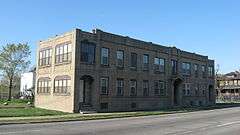


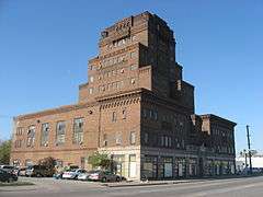

 Gary Public Schools Memorial Auditorium
Sister cities
Notable people
The Jacksons

Gary is the hometown of The Jackson 5, a family of musicians who influenced the sound of modern popular music. In 1950, Joseph and Katherine Jackson moved from East Chicago, Indiana[45] into their two bedroom house at 2300 Jackson St. in Gary, Indiana, after they were married on November 5, 1949. The famous siblings would later record a song entitled "2300 Jackson Street" in 1989. The Jackson family members:
- Maureen Reillette "Rebbie" Jackson (born May 29, 1950)
- Sigmund Esco "Jackie" Jackson (born May 4, 1951)
- Toriano Adaryll "Tito" Jackson (born October 15, 1953)
- Jermaine La Jaune Jackson (born December 11, 1954)
- La Toya Yvonne Jackson (born May 29, 1956)
- Marlon David Jackson (born March 12, 1957)
- Michael Joseph Jackson (August 29, 1958 – June 25, 2009)
- Steven Randall "Randy" Jackson (born October 29, 1961)
- Janet Damita Jo Jackson (born May 16, 1966)
Other notable people

- Orsten Artis, NCAA champion with the historic Texas Western Miners basketball team
- Dan Barreiro, sports radio talk show host
- Bob Benoit (1927–2008), Hollywood Park Racetrack chief executive
- Albert M. Bielawski, early 20th Century Michigan politician
- Frank Borman (born 1928), astronaut on Gemini 7 and Apollo 8, former CEO of Eastern Air Lines
- Lyman Bostock (1950–78), Major League Baseball player for California Angels and Minnesota Twins
- John Brim (1922–2003), bluesman
- Donna Britt, Washington Post journalist and author
- Avery Brooks (born 1948), (born in Evansville) actor, director, best known for Star Trek: Deep Space Nine
- Vic Bubas (born 1927), head basketball coach at Duke University 1959-69
- Vivian Carter (1921–1989), music producer, co-founder of Vee-Jay Records label
- John Chickerneo (1917–1995), NFL player
- Alan Roger Currie (born 1963), author, public speaker, radio personality
- Tony DeSantis (1914–2007), founder of Drury Lane theaters
- Polly Draper (born 1955), actress
- Karen Freeman-Wilson (born 1960), Indiana Attorney General, attorney, politician
- Harry Flournoy, basketball player
- Freddie Gibbs (born 1982), rapper
- Tom Harmon (1919–1990), 1940 Heisman Trophy winner for Michigan, sportscaster, father of actor Mark Harmon
- LaTroy Hawkins (born 1972), MLB pitcher for 21 years
- Eric Hillman (born 1966), MLB and Japan pitcher
- Gerald Irons (born 1949), NFL player
- Johnny Jackson (1951–2006), drummer for the Jackson 5. Murdered in Gary in 2006
- Jason Johnson (born 1965), NFL player
- Tank Johnson (born 1981), NFL player
- Alex Karras (1935–2012), winner of Outland Trophy, member of College Football Hall of Fame, NFL player and actor (Blazing Saddles, Webster)
- Robert Kearns (1927–2005), inventor of intermittent windshield wiper systems, subject of Flash of Genius
- Ron Kittle (born 1958), Chicago White Sox outfielder and 1983 American League Rookie of the Year recipient
- Bob Kuechenberg (born 1947), NFL lineman, two-time Super Bowl champion with Miami Dolphins
- Karl Malden (1912–2009), (born in Chicago), Oscar-winning actor
- William Marshall (1924-2003), stage and film actor
- Lloyd McClendon (born 1959), professional baseball player, manager of Pittsburgh Pirates, Seattle Mariners[46]
- Robert A. McDonald (born 1953), CEO of Procter & Gamble and Secretary of Veterans Affairs under President Barack Obama
- Brandon Moore (born 1980), NFL player
- Sista Monica Parker (1956–2014), electric blues, blues rock, gospel and soul singer, songwriter, and record producer[47]
- Jerilynn Patton, known as Jlin, electronic musician
- Jon Petrovich (1947–2011), television executive for CNN
- Dan Plesac (born 1962), Major League Baseball pitcher with an 18-year career, now a MLB Network analyst
- Jesse Powell (born 1971), recording artist
- Elizabeth Brown Pryor (1951–2015), author and diplomat
- Jimmy Reed, musician in Blues Hall of Fame
- Glenn Robinson (born 1973), NBA player and league's No. 1 draft pick, father of Glenn Robinson III
- Glenn Robinson III (born 1994), NBA player
- Paul Samuelson (1915–2009), economist, recipient of the John Bates Clark Medal (1947) and the Nobel Prize (1970)
- Joseph Stiglitz (born 1943), economist, recipient of the John Bates Clark Medal (1979) and the Nobel prize (2001)
- Hank Stram (1923–2005), NFL head coach 1960–1977, member of Pro Football Hall of Fame
- Jeanne Stunyo (born 1936), diver, Olympic silver medalist
- Ernest Lee Thomas (born 1949), actor (What's Happening!!)
- Deniece Williams (born 1950), Grammy Award-winning R&B artist
- Fred Williamson (born 1938), NFL player, actor, director, producer
- Tony Zale (1913–1997), twice middleweight champion, member of International Boxing Hall of Fame
Business and industry
Media
- Newspapers – Gary is served by two major newspapers based outside the city, and by a Gary-based, largely African-American interest paper. These papers provide regional topics, and cover events in Gary.
- The Post-Tribune, originally the Gary Post-Tribune, is now based in Merrillville, a suburb of Gary.
- The Times, previously known as the Hammond Times. Offices and facilities for The Times are in nearby Munster.
- The Gary Crusader, based in Gary and largely focused on black or African-American interests and readership.
- The INFO Newspaper, based in Gary and largely focused on black or African-American interests and readership.
- The Chicago Tribune and the Chicago Sun-Times are also distributed in Gary.
- Broadcast – Gary is served by five local broadcasters plus government access and numerous Chicago area radio and TV stations, and by other nearby stations in Illinois and Indiana.
- WHNW-LD (Channel 18) a repeater of LeSEA's WHME in South Bend.[48]
- WPWR-TV (Channel 50) is the Chicago CW and MyNetworkTV affiliate, but is licensed to Gary. Studios and transmitters are co-located with WFLD's in Chicago, and like WFLD, WPWR is owned by Fox Television Stations.
- WYIN (Channel 56) is a PBS affiliate licensed to Gary. Their studios are in Merrillville.
- WGVE (FM 88.7) is owned by the Gary Community School Corporation, and is used primarily as a teaching facility. Programming is maintained by students in the broadcast program at the Gary Career Center. WGVE also carries limited NPR programming.
- WLTH (AM 1370) carries syndicated talk programming, and is owned by Pluria Marshall Jr.
- WWCA (AM 1270) is a Relevant Radio owned-and-operated radio station, carrying programming from the Catholic-oriented Relevant Radio network.
See also
- List of tallest buildings in Gary
- Northwest Indiana
- Neighborhoods in Gary, Indiana
References
- 1 2 3 U.S. Geological Survey Geographic Names Information System: City of Gary
- ↑ "2014 Public Officials Directory". Lake County Board of Elections and Voter's Registration. Retrieved 2014-06-30.
- 1 2 "G001 - Geographic Identifiers - 2010 Census Summary File 1". United States Census Bureau. Retrieved 2015-07-28.
- 1 2 3 "American FactFinder". United States Census Bureau. Retrieved December 11, 2012.
- ↑ City of Gary (2008). City of Gary, Indiana Comprehensive Plan (PDF). p. 58.
- ↑ "American FactFinder - Results". US Bureau of the Census. Retrieved 2014-04-05.
- ↑ Engel, Pamela (2013-06-20). "Gary, Indiana Is Deteriorating So Much That It May Cut Off Services To Nearly Half Of Its Land". Business Insider. Retrieved 2014-04-06.
- ↑ The South Shore Journal, 1.http://www.southshorejournal.org/index.php/issues/volume-1-2006/78-journals/vol-1-2006/117-alice-gray-dorothy-buell-and-naomi-svihla-preservationists-of-ogden-dunes
- ↑ Smith, Stephanie. "The Historical Roots of The Nature Conservancy in the Northwest Indiana/Chicagoland Region: From Science to Preservation". South Shore Journal. Retrieved 2015-11-22.
- ↑ O'Hara, S. Paul (2011). Gary, the most American of all American cities. Bloomington, Ind. [u.a.]: Indiana Univ. Press. ISBN 9780253222886.
- ↑ Puente, Michael (March 9, 2012). "Gary's National Black Political Convention, 40 years on". WBEZ. Retrieved October 7, 2016.
- ↑ "Harper's Index". Harper's. Harper's Foundation. 327 (1,962): 17. November 2013. Retrieved December 30, 2013.(subscription required)
- ↑ Carlson, Carole (17 February 2014). "Gary ponders closing schools to save money". Post Tribute. Retrieved 1 April 2014.
- ↑ Kirk, Chelsea. "For sale: 11 schools, slightly used in Gary". Indiana Economic Digest. Retrieved April 1, 2014.
- ↑ NWI Times
- ↑ #08-870: Gary, Indiana Former Police Chief Convicted on Federal Civil Rights Violation (September 30, 2008). Justice.gov. Retrieved on 2011-03-22.
- ↑ Kwiatkowski, Marisa (November 27, 2010). "Former Gary police chief dies". The Times of Northwest Indiana. Retrieved December 30, 2013.
- ↑ Guzzardi, Will (April 8, 2011). "Gary, Indiana Mayor Rudy Clay Not Seeking Re-Election Due To Illness". Huffingtonpost.com. Retrieved April 25, 2012.
- ↑ "Democrat Karen Freeman-Wilson easily wins election as Gary's first woman mayor". Daily Reporter. Associated Press. August 11, 2011. Retrieved August 11, 2011.
- ↑ "Indiana Historic Architecture Editorials". Preserveindiana.com. Retrieved April 25, 2012.
- ↑ "Blaze Hits Downtown Gary". Chicago Tribune. October 13, 1997. Retrieved April 24, 2012.
- ↑ "It's Miller's time in Lake County". Indiana Economic Digest. April 16, 2006. Retrieved April 25, 2012.
- ↑ Havill, Adrian. "NYC to Washington and Back." Robert Philip Hanssen: The Spy who Stayed out in the Cold. Crime Library. Retrieved on April 12, 2012.
- ↑ "Weatherbase: Historical Weather for Gary, Indiana". Weatherbase. Retrieved February 18, 2013.
- ↑ "Gary Weather | Gary IN | Conditions, Forecast, Average". Idcide.com. Retrieved 2015-11-22.
- ↑ "Annual Estimates of the Resident Population for Incorporated Places: April 1, 2010 to July 1, 2015". Retrieved July 2, 2016.
- ↑ "U.S. Decennial Census". Census.gov. Archived from the original on April 22, 2013. Retrieved June 6, 2013.
- ↑ "Annual Estimates of the Resident Population: April 1, 2010 to July 1, 2013". Census.gov. Retrieved July 11, 2014.
- ↑ "Gary (city), Indiana". State & County QuickFacts. U.S. Census Bureau.
- ↑ "Indiana – Race and Hispanic Origin for Selected Cities and Other Places: Earliest Census to 1990". U.S. Census Bureau.
- ↑ "Locations & Hours." Gary Public Library System. Retrieved on January 21, 2009.
- ↑ Christin Nance Lazerus (March 31, 2011). "Gary's main library closing". Chicago Sun-Times. Retrieved March 31, 2011.
- ↑ Archived December 25, 2008, at the Wayback Machine.
- ↑ "Library - Indiana University Northwest". Iun.edu. Retrieved 2015-11-22.
- ↑ "Gary Fire Department provides a high quality emergency fire rescue and emergency medical service". Gary.in.us. Retrieved 2015-11-22.
- ↑ Benman, Keith. (October 27, 2009) National Guard armory ready to serve at Gary airport. Nwitimes.com. Retrieved on 2011-03-22.
- ↑ "Featured Articles from the Chicago Tribune". Chicago Tribune.
- ↑ 'Transformers' set in Gary explosive. Nwitimes.com (August 17, 2010). Retrieved on 2011-03-22.
- ↑ "Shows". HISTORY.
- ↑ Osipoff, Michael. "RailCats not afraid of Wichita for championship series", Chicago Sun-Times 11 October 2013. Retrieved on 03 September 2014.
- ↑ American Association Baseball "RailCats Claim 2013 Championship", 14 September 2013. Retrieved on 03 September 2014.
- ↑ "Mayor Clay's Statement on Gary's 1st Trade Mission to China: Press Statement" (PDF). May 22, 2008. Retrieved January 14, 2010.
- ↑ "Gary Indiana" (PDF). US Sister Cities by State with Affiliated African Countries. Retrieved March 28, 2015.
- ↑ "State". The Kokomo Tribune from Kokomo, Indiana. November 25, 1991: 21.
- ↑ Jackson, Katherine; Rich Wiseman (1990). My Family, the Jacksons. St. Martin's Paperbacks. ISBN 0-312-92350-3.
- ↑ "Lloyd McClendon Stats". Baseball Almanac. Retrieved October 30, 2012.
- ↑ Richard Skelly. "Sista Monica Parker | Biography & History". AllMusic. Retrieved 2015-11-22.
- ↑ "Query the FCC's TV station database for WHNW-LD". Fcc.gov. Retrieved April 25, 2012.
Further reading
- Lane, James (1978). City of the Century": A History of Gary, Indiana. Bloomington, Indiana: Indiana University Press. ISBN 0-253-11187-0.
- Lane, James (2006). Gary's First Hundred Years: A Centennial History of Gary, Indiana 1906-2006. Valparaiso, Indiana: Home Mountain Printing. ISBN 0-9773511-1-4.
- Lane, James B.; Cohen, Ronald D. (2003). Gary, Indiana : a pictorial history. Virginia Beach, VA: Donning Co. Publishers. ISBN 9781578642106.
- Mohl, Raymond A.; Betten, Neil (1986). Steel city : urban and ethnic patterns in Gary, Indiana, 1906-1950. New York: Holmes & Meier. ISBN 978-0841910775.
- O'Hara, S. Paul (2011). Gary, the most American of all American cities. Bloomington, Ind. [u.a.]: Indiana Univ. Press. ISBN 9780253222886.
External links
| Wikimedia Commons has media related to Gary, Indiana. |
| Wikivoyage has a travel guide for Gary. |
Municipalities and communities of Lake County, Indiana, United States | ||
|---|---|---|
| Cities | ||
| Towns | ||
| Townships | ||
| CDPs | ||
| Other unincorporated communities |
| |
| Ghost towns |
| |
| Footnotes | ‡This populated place also has portions in an adjacent county or counties | |
| Major city |  | |
|---|---|---|
| Cities (over 30,000 in 2010) | ||
| Towns and villages (over 30,000 in 2010) |
| |
| Counties | ||
| Regions | ||
| Sub-regions | ||