Jasper County, Indiana
| Jasper County, Indiana | |
|---|---|
| County | |
|
Jasper County Courthouse in Rensselaer | |
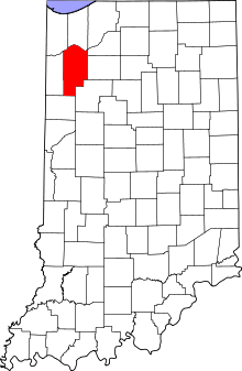 Location in the state of Indiana | |
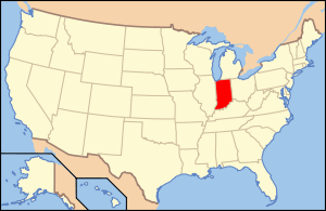 Indiana's location in the U.S. | |
| Coordinates: 41°01′N 87°07′W / 41.017°N 87.117°WCoordinates: 41°01′N 87°07′W / 41.017°N 87.117°W | |
| Country |
|
| State |
|
| Region | Northwest Indiana |
| Metro area | Chicago Metropolitan |
| Established | February 7, 1835 |
| Named for | Sgt. William Jasper |
| County seat | Rensselaer |
| Largest city |
Rensselaer (population and total area) |
| Incorporated Municipalities |
Four cities and towns
|
| Government | |
| • Type | County |
| • Body | Board of Commissioners |
| • Commissioner | James A. Walstra (1st) |
| • Commissioner | Kendell Culp (2nd) |
| • Commissioner | Richard E. Maxwell (3rd) |
| Area | |
| • County | 561.39 sq mi (1,454.0 km2) |
| • Land | 559.62 sq mi (1,449.4 km2) |
| • Water | 1.76 sq mi (4.6 km2) |
| • Metro | 10,874 sq mi (28,160 km2) |
| Area rank | 3rd largest county in Indiana |
| • Region | 2,726 sq mi (7,060 km2) |
| Elevation | 696 ft (212 m) |
| Population (2010) | |
| • County | 33,478 |
| • Estimate (2013) | 33,389 |
| • Rank |
54th largest county in Indiana 1,341st largest county in U.S.[1] |
| • Density | 59.8/sq mi (23.1/km2) |
| • Metro | 9,522,434 |
| • Region | 819,537 |
| Time zone | Central (UTC-6) |
| • Summer (DST) | Central (UTC-5) |
| ZIP Codes | 46310, 46341, 46374, 46392, 47922, 47943, 47946, 47948, 47957, 47959, 47977-78, 47995 |
| Area code | 219 |
| Congressional district | 4th |
| Indiana Senate districts | 5th and 7th |
| Indiana House of Representatives districts | 4th, 16th and 20th |
| FIPS code | 18-073 |
| GNIS feature ID | 0450494 |
| Interstate and U.S. Route |
|
| State Routes |
|
| Airport |
|
| Waterways |
Iroquois River – Kankakee River |
| Amtrak station | Rensselaer |
| Website | www.jaspercountyin.gov |
| |

| Demographics (2010)[2] | |||
|---|---|---|---|
| White | Black | Asian | |
| 95.8% | 0.6% | 0.4% | |
| Islander | Native | Other | Hispanic (any race) |
| 0.0% | 0.2% | 3.0% | 5.4% |
Jasper County is a county located in the U.S. state of Indiana. As of 2010, the population was 33,478.[3] The county seat is Rensselaer.[4]
Jasper County is included in the Chicago-Naperville-Elgin, IL-IN-WI Metropolitan Statistical Area.
History
Jasper County was formed in 1838. It was named for Sgt. William Jasper, a famous scout for the Continental Army during the American Revolutionary War.[5] Jasper became famous in 1776, during the bombardment of Fort Moultrie, for erecting a new flagstaff under fire after the American flag had been shot down. Jasper was killed during the Siege of Savannah in 1779.[6] Jasper County's twin county, Newton County, was named after Jasper's friend and comrade, John Newton.[7]
The Civil War
As early as 1825, the majority of the population were against slavery.[8] By the time the federal government declared war, Jasper County was one of the few counties of Indiana that had a military organization under the law of 1855.[9] The Civil War greatly affected Jasper County when they enlisted 935 soldiers on behalf of the Union. This large amount was considered an impressive amount at the time with the average population centered around 5,000 people,. Although there were several companies from Indiana, the 9th Indiana Infantry Regiment produced Robert H. Milroy, the "Gray Eagle of the Army". Milroy became famous for suppressing Confederate mountain rangers, which caused the Confederate Congress to declare a $100,000 bounty on his head. The 9th Indiana Infantry Regiment later became known for its involvement in the Battle of Philippi, one of the earliest battles of the Civil War at Laurel Hill (now known as Laurel Mountain).[10] In comparing the proportions of men able to fight, Indiana contributed more soldiers than any other state to the Union.[11]
Geography
According to the 2010 census, the county has a total area of 561.39 square miles (1,454.0 km2), of which 559.62 square miles (1,449.4 km2) (or 99.68%) is land and 1.76 square miles (4.6 km2) (or 0.31%) is water.[12] Until the middle of the 19th century when it was drained to make farmland, this county was part of the 2nd largest freshwater wetland in the US, with abundant flora and fauna.[13] This is caused by the Iroquois River. The Iroquois River is one of the main tributaries of the Kankakee River and flows throughout Jasper County. This allowed it to act as a major water source for the community.[14]
Major highways
Railroads
Adjacent counties
- Porter County (north)
- Lake County (northwest)
- Newton County (west)
- Benton County (south)
- La Porte County (northeast)
- Starke County (east)
- Pulaski County (east)
- White County (southeast)
Municipalities
The municipalities in Jasper County, and their populations as of the 2010 Census, are:
Cities
- Rensselaer – 5,859
Towns
- De Motte – 3,814
- Remington – 1,185
- Wheatfield – 853
Census-designated places
- Collegeville – 330
- Roselawn – 4,131
Townships
The 13 townships of Jasper County, with their populations as of the 2010 Census, are:
Education
Residents of Jasper County attend public schools administered by four different districts in multiple counties:
- Kankakee Valley School Corporation
- Rensselaer Central Schools Corporation
- Tri-County School Corporation
- West Central School Corporation
High Schools
- Kankakee Valley High School
- Rensselaer Central High School
- Covenant Christian High School in DeMotte (grades 9-12)
Middle Schools
Elementary Schools
- DeMotte Elementary School
- Kankakee Valley Intermediate School
- Van Rensselaer Elementary School
- Wheatfield Elementary School
- DeMotte Christian Elementary School (Preschool through 8th)
- Tri-County Primary School (K-2nd)
- St.Augustine Catholic School
Colleges and Universities
Hospitals
- Franciscan Health Rensselaer, Rensselaer – 46 beds[15]
Climate and weather
| Rensselaer, Indiana | ||||||||||||||||||||||||||||||||||||||||||||||||||||||||||||
|---|---|---|---|---|---|---|---|---|---|---|---|---|---|---|---|---|---|---|---|---|---|---|---|---|---|---|---|---|---|---|---|---|---|---|---|---|---|---|---|---|---|---|---|---|---|---|---|---|---|---|---|---|---|---|---|---|---|---|---|---|
| Climate chart (explanation) | ||||||||||||||||||||||||||||||||||||||||||||||||||||||||||||
| ||||||||||||||||||||||||||||||||||||||||||||||||||||||||||||
| ||||||||||||||||||||||||||||||||||||||||||||||||||||||||||||
In recent years, average temperatures in Rensselaer have ranged from a low of 14 °F (−10 °C) in January to a high of 85 °F (29 °C) in July, although a record low of −25 °F (−32 °C) was recorded in January 1985 and a record high of 104 °F (40 °C) was recorded in August 1988. Average monthly precipitation ranged from 1.67 inches (42 mm) in February to 4.34 inches (110 mm) in June.[16]
Government
The county government is a constitutional body, and is granted specific powers by the Constitution of Indiana, and by the Indiana Code.
County Council: The county council is the legislative branch of the county government and controls all the spending and revenue collection in the county. Representatives are elected from county districts. The council members serve four-year terms. They are responsible for setting salaries, the annual budget, and special spending. The council also has limited authority to impose local taxes, in the form of an income and property tax that is subject to state level approval, excise taxes, and service taxes.[17][18]
Board of Commissioners: The executive body of the county is made of a board of commissioners. The commissioners are elected county-wide, in staggered terms, and each serves a four-year term. One of the commissioners, typically the most senior, serves as president. The commissioners are charged with executing the acts legislated by the council, collecting revenue, and managing the day-to-day functions of the county government.[17][18]
Court: The county maintains a small claims court that can handle some civil cases. The judge on the court is elected to a term of four years and must be a member of the Indiana Bar Association. The judge is assisted by a constable who is also elected to a four-year term. In some cases, court decisions can be appealed to the state level circuit court.[18]
County Officials: The county has several other elected offices, including sheriff, coroner, auditor, treasurer, recorder, surveyor, and circuit court clerk Each of these elected officers serves a term of four years and oversees a different part of county government. Members elected to any county government position are required to declare a political party affiliation and to be residents of the county.[18]
Jasper County is part of Indiana's 1st congressional district and in 2008 was represented by Pete Visclosky in the United States Congress.[19] It is also part of Indiana Senate districts 5 and 7[20] and Indiana House of Representatives districts 4, 16 and 20.[21]
Demographics
| Historical population | |||
|---|---|---|---|
| Census | Pop. | %± | |
| 1840 | 1,267 | — | |
| 1850 | 3,540 | 179.4% | |
| 1860 | 4,291 | 21.2% | |
| 1870 | 6,354 | 48.1% | |
| 1880 | 9,464 | 48.9% | |
| 1890 | 11,185 | 18.2% | |
| 1900 | 14,292 | 27.8% | |
| 1910 | 13,044 | −8.7% | |
| 1920 | 13,961 | 7.0% | |
| 1930 | 13,388 | −4.1% | |
| 1940 | 14,397 | 7.5% | |
| 1950 | 17,031 | 18.3% | |
| 1960 | 18,842 | 10.6% | |
| 1970 | 20,429 | 8.4% | |
| 1980 | 26,138 | 27.9% | |
| 1990 | 24,960 | −4.5% | |
| 2000 | 30,043 | 20.4% | |
| 2010 | 33,478 | 11.4% | |
| Est. 2015 | 33,470 | [22] | 0.0% |
| U.S. Decennial Census[23] 1790-1960[24] 1900-1990[25] 1990-2000[26] 2010-2013[3] | |||
As of the 2010 United States Census, there were 33,478 people, 12,232 households, and 9,165 families residing in the county.[27] The population density was 59.8 inhabitants per square mile (23.1/km2). There were 13,168 housing units at an average density of 23.5 per square mile (9.1/km2).[12] The racial makeup of the county was 95.8% white, 0.6% black or African American, 0.4% Asian, 0.2% American Indian, 2.0% from other races, and 1.0% from two or more races. Those of Hispanic or Latino origin made up 5.4% of the population.[27] In terms of ancestry, 27.6% were German, 16.5% were Irish, 9.6% were Dutch, 9.3% were English, 6.9% were American, and 6.0% were Polish.[28]
Of the 12,232 households, 35.8% had children under the age of 18 living with them, 60.7% were married couples living together, 9.3% had a female householder with no husband present, 25.1% were non-families, and 20.9% of all households were made up of individuals. The average household size was 2.66 and the average family size was 3.07. The median age was 38.0 years.[27]
The median income for a household in the county was $47,697 and the median income for a family was $63,842. Males had a median income of $50,984 versus $32,313 for females. The per capita income for the county was $23,676. About 7.7% of families and 9.0% of the population were below the poverty line, including 14.1% of those under age 18 and 5.7% of those age 65 or over.[29]
Religion
The Catholic church is the biggest denomination in the county with 4,341 members, the second largest is the Reformed Church in America with 1,502 members and 2 churches (First Church and American Reformed Church) the third is the United Methodist Church with 1,300 members, the fourth largest is the Christian Reformed Church in North America with 1,013 members in 3 congregations as of 2010.[30]
See also
References
- ↑ "USA Counties in Profile". STATS Indiana. Retrieved 2014-06-29.
- ↑ U.S. Census Bureau. American Community Survey, Profile of General Population and Housing Characteristics 2010, Table DP-1, 2010 Demographic Profile Data. American FactFinder. Retrieved 2014-06-29.
- 1 2 "Jasper County QuickFacts". United States Census Bureau. Retrieved 2011-09-25.
- ↑ "Find a County". National Association of Counties. Retrieved 2011-06-07.
- ↑ Gannett, Henry (1905). The Origin of Certain Place Names in the United States. Govt. Print. Off. p. 168.
- ↑ De Witt Clinton Goodrich & Charles Richard Tuttle (1875). An Illustrated History of the State of Indiana. Indiana: R. S. Peale & co. p. 562.
- ↑ Hamilton Louis H. & William Darroch (1916). A Standard History of Jasper and Newton Counties Indiana, Volume 1. Chicago & New York: the Lewis Publishing Company. p. 45.
- ↑ Scudder, Horace E (1888). Indiana: American Commonwealths. Cambridge: Boston & New York: The Riverside Press, Cambridge. pp. 235, 237,438–400.
- ↑ Hamilton Louis H. & William Darroch (1916). A Standard History of Jasper and Newton Counties Indiana, Volume 1. Chicago & New York: the Lewis Publishing Company. p. 159.
- ↑ Hamilton Louis H. & William Darroch (1916). A Standard History of Jasper and Newton Counties Indiana, Volume 1. Chicago & New York: the Lewis Publishing Company. p. 115,118.
- ↑ Hoover Dwight W. (1980). A Pictorial History of Indiana. Bloomington: the Indiana University Press. p. 93.
- 1 2 "Population, Housing Units, Area, and Density: 2010 - County". United States Census Bureau. Retrieved 2015-07-10.
- ↑ Everglades of the North at the Internet Movie Database
- ↑ Battle J.H. (1883). Counties of Warren, Benton, Jasper and Newton. Chicago: F.A. Battey & Co. p. 411.
- ↑ "Franciscan Health is New Name for Leading Hospital System". Franciscan Alliance, Inc. September 6, 2016. Retrieved 2016-09-11.
- 1 2 "Monthly Averages for Rensselaer, Indiana". The Weather Channel. Retrieved 2011-01-27.
- 1 2 Indiana Code. "Title 36, Article 2, Section 3". IN.gov. Retrieved 2008-09-16.
- 1 2 3 4 Indiana Code. "Title 2, Article 10, Section 2" (PDF). IN.gov. Retrieved 2008-09-16.
- ↑ "US Congressman Pete Visclosky". US Congress. Retrieved 2008-10-08.
- ↑ "Indiana Senate Districts". State of Indiana. Retrieved 2011-07-14.
- ↑ "Indiana House Districts". State of Indiana. Retrieved 2011-07-14.
- ↑ "County Totals Dataset: Population, Population Change and Estimated Components of Population Change: April 1, 2010 to July 1, 2015". Retrieved July 2, 2016.
- ↑ "U.S. Decennial Census". United States Census Bureau. Retrieved July 10, 2014.
- ↑ "Historical Census Browser". University of Virginia Library. Retrieved July 10, 2014.
- ↑ "Population of Counties by Decennial Census: 1900 to 1990". United States Census Bureau. Retrieved July 10, 2014.
- ↑ "Census 2000 PHC-T-4. Ranking Tables for Counties: 1990 and 2000" (PDF). United States Census Bureau. Retrieved July 10, 2014.
- 1 2 3 "DP-1 Profile of General Population and Housing Characteristics: 2010 Demographic Profile Data". United States Census Bureau. Retrieved 2015-07-10.
- ↑ "DP02 SELECTED SOCIAL CHARACTERISTICS IN THE UNITED STATES – 2006-2010 American Community Survey 5-Year Estimates". United States Census Bureau. Retrieved 2015-07-10.
- ↑ "DP03 SELECTED ECONOMIC CHARACTERISTICS – 2006-2010 American Community Survey 5-Year Estimates". United States Census Bureau. Retrieved 2015-07-10.
- ↑ www.thearda.com/rcms2010/r/c/18/rcms2010_18073_county_name_2010.asp
External links
 |
Lake County | Porter County | La Porte County | |
| Newton County | |
Starke County and Pulaski County | ||
| ||||
| | ||||
| Benton County | White County |
Municipalities and communities of Jasper County, Indiana, United States | ||
|---|---|---|
| City | ||
| Towns | ||
| Townships | ||
| CDPs | ||
| Other unincorporated communities | ||
| Footnotes | ‡This populated place also has portions in an adjacent county or counties | |
| Major city |  | |
|---|---|---|
| Cities (over 30,000 in 2010) | ||
| Towns and villages (over 30,000 in 2010) |
| |
| Counties | ||
| Regions | ||
| Sub-regions | ||