Garberville, California
| Garberville | |
|---|---|
| census-designated place | |
|
Downtown Garberville has an active retail district. | |
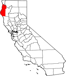
 Garberville Location in California | |
| Coordinates: 40°6′N 123°48′W / 40.100°N 123.800°WCoordinates: 40°6′N 123°48′W / 40.100°N 123.800°W | |
| Country |
|
| State |
|
| County | Humboldt County |
| Area[1] | |
| • Total | 2.762 sq mi (7.154 km2) |
| • Land | 2.705 sq mi (7.006 km2) |
| • Water | 0.057 sq mi (0.148 km2) 2.1% |
| Elevation[2] | 535 ft (163 m) |
| Population (2010) | |
| • Total | 913 |
| • Density | 330/sq mi (130/km2) |
| Time zone | Pacific (PST) (UTC-8) |
| • Summer (DST) | PDT (UTC-7) |
| ZIP Code | 95542 |
| Area code(s) | 707 |
| GNIS feature IDs | 224036; 2611433 |
| U.S. Geological Survey Geographic Names Information System: Garberville, California; U.S. Geological Survey Geographic Names Information System: Garberville, California | |

Garberville is a census-designated place[3] in Humboldt County, California.[2] It is located on the South Fork of the Eel River 52 miles (84 km) south-southeast of Eureka,[4] at an elevation of 535 feet (163 m).[2] The population was 913 at the 2010 United States Census. It is approximately 200 miles (320 km) north of San Francisco, California, and within a fifteen-minute drive to Humboldt Redwoods State Park and a sixty-minute drive to Eureka, the county seat. Garberville is the primary town in the area known as the Mateel Region, consisting of parts of the Mattole and Eel River watersheds in southern Humboldt and northern Mendocino counties.
History
Prior to recorded history the area was populated by southern Sinkyone people.[5]
In 1853 a Spanish explorer, Antone Garcia, settled in the area near Town Gulch, which runs through modern-day Garberville.[6] J.E. Wood, one of the members of the Josiah Gregg exploring party of 1849, laid out the town in 1862.[4] The first post office in Garberville opened in 1874.[4] Jacob C. Garber the town postmaster later named the town after himself[7][8] in 1879.[9]
Geography
Garberville is located at 40°06′01″N 123°47′42″W / 40.10028°N 123.79500°W. The town is stretched out in a small forested valley bisected by U.S. Route 101, at an elevation of 535 feet (163 m). The nearby King's Peak rises to 4,087 feet (1,246 m).
Climate
The Köppen Climate Classification subtype for this climate is "Csb". (Mediterran Climate), characterized by cold, rainy winters and hot, dry summers.[10]
| Climate data for Garberville, California | |||||||||||||
|---|---|---|---|---|---|---|---|---|---|---|---|---|---|
| Month | Jan | Feb | Mar | Apr | May | Jun | Jul | Aug | Sep | Oct | Nov | Dec | Year |
| Average high °F (°C) | 50 (10) |
55 (13) |
60 (16) |
64 (18) |
71 (22) |
78 (26) |
86 (30) |
87 (31) |
83 (28) |
70 (21) |
56 (13) |
49 (9) |
67 (19) |
| Average low °F (°C) | 37 (3) |
38 (3) |
39 (4) |
41 (5) |
45 (7) |
50 (10) |
53 (12) |
53 (12) |
49 (9) |
45 (7) |
41 (5) |
37 (3) |
44 (7) |
| Average precipitation inches (mm) | 3.2 (81) |
10.3 (262) |
8.9 (226) |
4.5 (114) |
1.9 (48) |
0.6 (15) |
0.1 (3) |
0.4 (10) |
0.9 (23) |
3.9 (99) |
9.6 (244) |
13.7 (348) |
68 (1,730) |
| Source: Weatherbase [11] | |||||||||||||
Demographics
The 2010 United States Census[12] reported that Garberville had a population of 913. The population density was 330.5 people per square mile (127.6/km²). The racial makeup of Garberville was 815 (89.3%) White, 14 (1.5%) African American, 29 (3.2%) Native American, 17 (1.9%) Asian, 0 (0.0%) Pacific Islander, 7 (0.8%) from other races, and 31 (3.4%) from two or more races. Hispanic or Latino of any race were 54 persons (5.9%).
The Census reported that 785 people (86.0% of the population) lived in households, 128 (14.0%) lived in non-institutionalized group quarters, and 0 (0%) were institutionalized.
There were 390 households, out of which 86 (22.1%) had children under the age of 18 living in them, 102 (26.2%) were opposite-sex married couples living together, 47 (12.1%) had a female householder with no husband present, 33 (8.5%) had a male householder with no wife present. There were 50 (12.8%) unmarried opposite-sex partnerships, and 5 (1.3%) same-sex married couples or partnerships. 172 households (44.1%) were made up of individuals and 49 (12.6%) had someone living alone who was 65 years of age or older. The average household size was 2.01. There were 182 families (46.7% of all households); the average family size was 2.69.
The population was spread out with 160 people (17.5%) under the age of 18, 85 people (9.3%) aged 18 to 24, 258 people (28.3%) aged 25 to 44, 285 people (31.2%) aged 45 to 64, and 125 people (13.7%) who were 65 years of age or older. The median age was 40.0 years. For every 100 females there were 109.9 males. For every 100 females age 18 and over, there were 105.2 males.
There were 434 housing units at an average density of 157.1 per square mile (60.7/km²), of which 175 (44.9%) were owner-occupied, and 215 (55.1%) were occupied by renters. The homeowner vacancy rate was 2.2%; the rental vacancy rate was 2.3%. 388 people (42.5% of the population) lived in owner-occupied housing units and 397 people (43.5%) lived in rental housing units.
Economy
The main street of Garberville, U.S. Business 101 is lined with small shops, gas stations, grocery store and the only movie house in the area, the Art-Deco-style single-screen Garberville Theater.
Marijuana cultivation has replaced timber as the economic driver of Garberville and neighboring Redway. There is a Cannabis College in Garberville,[13] and the town has been called "the marijuana heartland of the U.S." by BBC News.[13]
Reggae on the River, an annual music festival, is held near Garberville. Nearby the 1925 Tudor Revival Benbow Inn is on the National Register of Historic Places.
Government
Politics
In the state legislature, Garberville is in the 2nd Senate District, represented by Democrat Mike McGuire,[14] and the 2nd Assembly District, represented by Democrat Jim Wood.[15]
Federally, Garberville is in California's 2nd congressional district, represented by Democrat Jared Huffman.[16]
Incorporation
A proposal to incorporate Garberville as a city[17] was dropped after county supervisors declined to form a Municipal Advisory Committee due to concerns over the associated costs. A group of local residents once attempted to qualify a "Sequoia County" initiative to secede from both Humboldt and Mendocino County with Garberville as the new county seat, although the campaign ended without gathering enough signatures.[17] A local chapter of the Green Party was formed in 2006.[18]
Education
The Southern Humboldt Unified School District was created from 19 separate school districts in 1948[19] and currently serves about 800 students in an area of 745 square miles (1,930 km2).[17] The district has five elementary, one high school and one learning center.
- Redway School[20]
- Whitethorn School[21]
- Agnes Johnson School[22]
- Casterlin School[23]
- Ettersburg School[24]
- South Fork High School[25]
- Osprey Learning Center[26]
Media
Garberville is home to both weekly newspapers in the Mateel Region, the locally owned Independent[17] and Redwood Times, run by Media News Group as a sister publication of the daily Times-Standard from Eureka.[27] Redwood Community Radio, KMUD, broadcasts from Garberville at 91.1 FM.[28]
Infrastructure
Transportation
U.S. Route 101 bypasses the town with exits #639 and #642 at Garberville and Redway respectively.
Humboldt Transit Authority serves from Garberville as far north as Trinidad.
Garberville is served by Amtrak Thruway Motorcoach for out of region public transportation.
Garberville Airport is a public airport located 2 miles (3.2 km) southwest of town.[29]
Utilities
Garberville's ZIP Code is 95542.[30] The community is inside area code 707.[31]
The Garberville Fire Protection District, has three engines and a utility truck, self-contained breathing apparatuses and radios.[32] The Garberville Water Company supplies drinking water to residents and maintains 27 fire hydrants on its water lines.[32] The Garberville Sanitary District is not the same as the water company, but provides sewers in the core of the fire district.[32] Some releases of water have contained one or more toxins.[33]
Health care
The Jerold Phelps Community Hospital[17] is administered by the Southern Humboldt Community Healthcare District.[34]
Notable residents
Major League Baseball player Marshall Brant was born in Garberville.[35]
See also
-
 California portal
 - Avenue of the Giants
- Eel River Athapaskan traditional narratives
| Wikimedia Commons has media related to Garberville, California. |
References
- ↑ "2010 Census U.S. Gazetteer Files – Places – California". United States Census Bureau.
- 1 2 3 U.S. Geological Survey Geographic Names Information System: Garberville, California
- ↑ U.S. Geological Survey Geographic Names Information System: Garberville, California
- 1 2 3 Durham, David L. (1998). California's Geographic Names: A Gazetteer of Historic and Modern Names of the State. Clovis, Calif.: Word Dancer Press. p. 64. ISBN 1-884995-14-4.
- ↑ Victor Golla (2 August 2011). California Indian Languages. University of California Press. pp. 76–. ISBN 978-0-520-26667-4.
- ↑ Turner, Dennis W. & Gloria H. (2010). Place Names of Humboldt County, California (2nd edition). Orangevale, CA: Dennis W. & Gloria H. Turner. pp. 105, 236. ISBN 978-0-9629617-2-4.
- ↑ Gannett, Henry (1905). The Origin of Certain Place Names in the United States. Govt. Print. Off. p. 134.
- ↑ "Profile for Garberville, California, CA". epodunk.com. Retrieved 9 May 2011.
- ↑ Gudde, Edwin G. (2004). California place names: The origin and etymology of current geographical names. Berkeley and Los Angeles, California: University of California Press. p. 140. ISBN 0-520-24217-3.
- ↑ Climate Summary for closest city on record
- ↑ "Weatherbase.com". Weatherbase. 2013. Retrieved on June 4, 2013.
- ↑ "2010 Census Interactive Population Search: CA - Garberville CDP". U.S. Census Bureau. Retrieved July 12, 2014.
- 1 2 Samani, Vishva (9 May 2011). "Blurred lines in California's cannabis capital". BBC News.
- ↑ "Senators". State of California. Retrieved March 10, 2013.
- ↑ "Members Assembly". State of California. Retrieved March 2, 2013.
- ↑ "California's 2nd Congressional District - Representatives & District Map". Civic Impulse, LLC. Retrieved March 1, 2013.
- 1 2 3 4 5 Ringwald, George (December 26, 2002). "Garberville circa 2002: A visit to that town down south". North Coast Journal. Retrieved November 3, 2013.
- ↑ Kirk, Eric, Sequoia County Greens to meet on Friday, SoHum Parlance, August 20, 2006
- ↑ Southern Humboldt Unified School District, 2012
- ↑ Redway School, Southern Humboldt Unified School District, 2013
- ↑ Whitethorn School, Southern Humboldt Unified School District, 2013
- ↑ Agnes Johnson School, Southern Humboldt Unified School District, 2013
- ↑ Casterlin School, Southern Humboldt Unified School District, 2013
- ↑ Ettersburg School, Southern Humboldt Unified School District, 2013
- ↑ South Fork High School, Southern Humboldt Unified School District, 2013
- ↑ Osprey Learning Center, Southern Humboldt Unified School District, 2013
- ↑ Redwood Times, Media News Group, 2013
- ↑ KMUD-FM, Redwood Community Radio Organization, 2013
- ↑ Webcams and AWOS screen at Garberville Airport
- ↑ USPS ZIP Code lookup tool
- ↑ Area Code Map, NANPA, 2013
- 1 2 3 Garberville Fire Protection District Municipal Service Review, September 2008, Humboldt Local Agency Formation Commission
- ↑ Garberville Sanitary District, Toxic Waters, New York Times, March 2010
- ↑ "Jerold Phelps Community Hospital". Hospital Southern Humboldt Community Healthcare District. 2013. Retrieved 3 November 2013.
- ↑ Marshall Lee Brant, BaseballReference.com, USA Today, 2013
External links
- Garberville-Redway Area Chamber of Commerce
- Garberville Theatre, history and photographs
Additional reading
- Schneider, Keith Garberville Journal; Marijuana Once Reigned as the King, New York Times, January 26, 1988