Myers Flat, California
| Myers Flat | |
|---|---|
| Census designated place | |
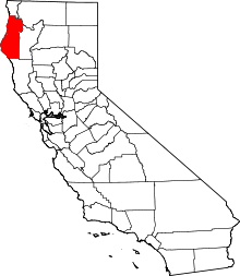
 Myers Flat Location in California | |
| Coordinates: 40°15′59″N 123°52′13″W / 40.26639°N 123.87028°WCoordinates: 40°15′59″N 123°52′13″W / 40.26639°N 123.87028°W | |
| Country |
|
| State |
|
| County | Humboldt County |
| Area[1] | |
| • Total | 0.487 sq mi (1.261 km2) |
| • Land | 0.432 sq mi (1.119 km2) |
| • Water | 0.055 sq mi (0.142 km2) 11.3% |
| Elevation[2] | 203 ft (62 m) |
| Population (April 1, 2010) | |
| • Total | 146 |
| • Density | 300/sq mi (120/km2) |
| Time zone | Pacific (UTC-8) |
| • Summer (DST) | PDT (UTC-7) |
| ZIP code | 95554 |
| Area code | 707 |
| GNIS feature IDs | 229396, 2611442 |
| U.S. Geological Survey Geographic Names Information System: Myers Flat, California; U.S. Geological Survey Geographic Names Information System: Myers Flat, California | |
Myers Flat (formerly, Myers) is a census-designated place[3] in Humboldt County, California.[2] It is located 4.5 miles (7.2 km) south-southeast of Weott,[4] at an elevation of 203 feet (62 m).[2] The ZIP Code is 95554.[5] The population was 146 at the 2010 census.
Originally called Myers from the Grant Myers Ranch, "Flat" was added to the name to distinguish the place from Meyers in El Dorado County.[4]
The Myers Flat post office opened in 1949.[4]
Myers Flat is located along the California State Route 254, also known as Avenue of the Giants. The US Post Office's ZIP Code is 95554. The community is inside area code 707.
History
Myers Flat was founded by the Myers family in the mid-19th century. The Myerses were some of the first homesteaders in the area, growing apples, pears, sweet potatoes, and corn.[6] The town initially served as a coach stop for travelers on their way to San Francisco. The Morrison-Jackson mill was started and was active for a long time until the mid 80s when the mill closed down. The old mill site and most of its land are now a part of Riverbend Cellars and much of the land is covered in grape vineyards. Much of the town was destroyed in the flood of 1964. Because of its shallow elevation and proximity to the Eel River, the town still has problems with flooding. The town lies below the 100-year flood line. Much of the town is trailers and cabins and some people have homes built to withstand flood waters.
Demographics
The 2010 United States Census[7] reported that Myers Flat had a population of 146. The population density was 299.8 people per square mile (115.8/km²). The racial makeup of Myers Flat was 125 (85.6%) White, 0 (0.0%) African American, 6 (4.1%) Native American, 1 (0.7%) Asian, 0 (0.0%) Pacific Islander, 4 (2.7%) from other races, and 10 (6.8%) from two or more races. Hispanic or Latino of any race were 11 persons (7.5%).
The Census reported that 146 people (100% of the population) lived in households, 0 (0%) lived in non-institutionalized group quarters, and 0 (0%) were institutionalized.
There were 80 households, out of which 15 (18.8%) had children under the age of 18 living in them, 13 (16.3%) were opposite-sex married couples living together, 6 (7.5%) had a female householder with no husband present, 9 (11.3%) had a male householder with no wife present. There were 9 (11.3%) unmarried opposite-sex partnerships, and 0 (0%) same-sex married couples or partnerships. 43 households (53.8%) were made up of individuals and 7 (8.8%) had someone living alone who was 65 years of age or older. The average household size was 1.83. There were 28 families (35.0% of all households); the average family size was 2.68.
The population was spread out with 20 people (13.7%) under the age of 18, 14 people (9.6%) aged 18 to 24, 33 people (22.6%) aged 25 to 44, 64 people (43.8%) aged 45 to 64, and 15 people (10.3%) who were 65 years of age or older. The median age was 46.7 years. For every 100 females there were 97.3 males. For every 100 females age 18 and over, there were 100.0 males.
There were 110 housing units at an average density of 225.9 per square mile (87.2/km²), of which 40 (50.0%) were owner-occupied, and 40 (50.0%) were occupied by renters. The homeowner vacancy rate was 9.1%; the rental vacancy rate was 0%. 82 people (56.2% of the population) lived in owner-occupied housing units and 64 people (43.8%) lived in rental housing units.
Facilities
Myers Flat's downtown consists of a general store, the Four Mori Market; a coffee–espresso shop called The Daily Grind; The Trading Post saloon; Drive Through Tree; an antique and used item store, Latz in the Flats; A gift shop called To Dye For Designs that does custom embroidery as well as unique tie-dye clothing; Riverbend Cellars Winery; the Groves restaurant; The Myers Inn, a bed and breakfast; and the Knights Restaurant (now closed). There is also a RV park called Giant Redwoods RV, and a laundromat called Myers Flat Laundromat (now closed). Some of the town is connected to the local Myers flat utilities and the town has its own volunteer fire department.
Culture
Because of its location at the southern entrance to Humboldt Redwoods State Park, the town receives much tourism during the summer months, The town has wine tasting and cold beer at the local market–saloon as well as off-sale liquor. Seasonally other events such as the redwood run and various music festivals bring people from all over the world to Myers Flat. Myers Flat is made up of many families and young people. The local slogan is "Myers Flat is where it's at".
Government
In the California State Legislature, Myers Flat is in the 2nd Senate District, represented by Democrat Mike McGuire,[8] and the 2nd Assembly District, represented by Democrat Jim Wood.[9]
In the United States House of Representatives, Myers Flat is in California's 2nd congressional district, represented by Democrat Jared Huffman.[10]
Climate
This region experiences warm (but not hot) and dry summers, with no average monthly temperatures above 71.6 °F. According to the Köppen Climate Classification system, Myers Flat has a warm-summer Mediterranean climate, abbreviated "Csb" on climate maps.[11]
See also
-
 California portal
References
- ↑ "2010 Census U.S. Gazetteer Files – Places – California". United States Census Bureau.
- 1 2 3 U.S. Geological Survey Geographic Names Information System: Myers Flat, California
- ↑ U.S. Geological Survey Geographic Names Information System: Myers Flat, California
- 1 2 3 Durham, David L. (1998). California's Geographic Names: A Gazetteer of Historic and Modern Names of the State. Clovis, Calif.: Word Dancer Press. p. 112. ISBN 1-884995-14-4.
- ↑ USPS ZIP Code lookup tool
- ↑ Hawk, Diane (2004). Touring the old redwood highway : Humboldt County. Arcata, Calif.: Hawk Mountaintop Pub. p. 69. ISBN 0-9672162-4-9.
- ↑ "2010 Census Interactive Population Search: CA - Myers Flat CDP". U.S. Census Bureau. Retrieved July 12, 2014.
- ↑ "Senators". State of California. Retrieved March 10, 2013.
- ↑ "Members Assembly". State of California. Retrieved March 2, 2013.
- ↑ "California's 2nd Congressional District - Representatives & District Map". Civic Impulse, LLC. Retrieved March 1, 2013.
- ↑ Climate Summary for Myers Flat, California