Fortuna, California
| Fortuna | |
|---|---|
| City | |
| City of Fortuna | |
|
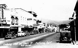
Main Street Fortuna in the 1940s | |
| Nickname(s): The Friendly City[1] | |
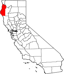
 Location in Humboldt County and the state of California | |
 Fortuna Location in the United States | |
| Coordinates: 40°35′53″N 124°09′26″W / 40.59806°N 124.15722°WCoordinates: 40°35′53″N 124°09′26″W / 40.59806°N 124.15722°W | |
| Country |
|
| State |
|
| County | Humboldt |
| Incorporated | January 20, 1906[2] |
| Government | |
| • Type | Council/Manager[3] |
| • Mayor | Douglas Strehl[3] |
| Area[4] | |
| • Total | 4.845 sq mi (12.549 km2) |
| • Land | 4.845 sq mi (12.549 km2) |
| • Water | 0 sq mi (0 km2) 0% |
| Elevation[5] | 66 ft (20 m) |
| Population (2010) | |
| • Total | 11,926 |
| • Density | 2,500/sq mi (950/km2) |
| Time zone | Pacific (PST) (UTC-8) |
| • Summer (DST) | PDT (UTC-7) |
| ZIP code | 95540 |
| Area code(s) | 707 |
| FIPS code | 06-25296 |
| GNIS feature IDs | 277520, 2410532 |
| Website |
friendlyfortuna |
Fortuna (formerly, Slide, Springville)[6] (Wiyot: Vutsuwitk Da'l, "ashes stay")[7] is a city the northeast shore of the Eel River (approximately 9 miles (14 km) from where it enters the Pacific Ocean), and is on U.S. Route 101 in west-central Humboldt County, California, United States. The population was 11,926 at the 2010 census, up from 10,497 at the 2000 census.
History
The settlement was originally called "Slide," for Slide Hill, in 1874, named for the slide that was a fixture on the northeast side of the Eel River and the southwest portion of Christian Ridge just to the northwest, near the edge of town. In 1875, the name was changed to Springville during the construction of the Springville Mill, a lumber mill for the nearby redwood forests, named so because of the numerous springs in the area. The mill's owners were Henry Rohner (namesake of neighboring Rohnerville), Alexander Masson, M. N. Weber and G. F. Gushaw. Springville was originally a company town belonging to the mill, and the few people that resided there all worked at the mill. By the late 1870s Springville had grown enough to warrant a post office, but a town called Springville, California (now part of Camarillo, in Ventura County) already existed in the state. The post office was named Slide on May 24, 1876.[6][8] In 1884 the residents petitioned the state legislature for the name Fortuna, Spanish for "fortune" and Latin for "chance," and by July 3, 1888 the name was changed to Fortuna.[6][9] The name was chosen when settlers saw the proximity of the forests, the river and its valley, and the Pacific Ocean, as ideal for enjoying a good quality of life, and felt "fortunate" to live there.[9] It is believed that a local minister and real estate agent, desiring to sell lots to newcomers, devised the name as a marketing tool.[8][9]
Electricity came to Fortuna in 1883 when W. J. Swortzel and George W. Williams (of Swortzel & Williams), owners of the Springville Mill Company, built a $4,000 power plant.[10] Some of the local sawmills were already powered by electricity, and by providing power to the mills, Swortzel and Williams saw the opportunity to also provide inexpensive electric lighting to the townspeople.[10]
The town was incorporated on February 20, 1906, and, because of the Eel River, became known for its agricultural prowess in vegetable crops, berries and fruits, and for the fresh fish from the river. Although agricultural industry was expanding, the lumber industry is what started the town, and would continue as the main source of local income for some time to come.[8]
Rohnerville (formerly Eel River Township), a town founded to service the many gold miners inhabiting the mountains to the north and east, was competing with Fortuna to be the leading township in the area. The miners would come by ship to Eureka, and then head up the Eel River to the junction with the Van Duzen River, from whence the miners headed east up the Van Duzen River Valley into Trinity County. Rohnerville was at this junction, and looked to prosper from selling supplies to the miners. But when it was decided that the railroad would be routed through neighboring Fortuna, it set both towns' fate.[8]
The Eel River and Eureka Railroad was built in 1884 to provide Humboldt Bay shipping access to the lumber mills and farms of the lower Eel River. Atchison, Topeka and Santa Fe Railway reorganized Fortuna's railroad as the San Francisco and Northwestern Railway in 1903, and then completed the Northwestern Pacific Railroad to San Francisco in 1914.[11] Fortuna became the rail hub for smaller communities like Alton, Fernbridge, Ferndale, Hydesville, Newburg, Port Kenyon, Rohnerville, and Waddington. Fortuna was the location of one of two secondary mills of the storied Pacific Lumber Company, headquartered ten miles south in Scotia.
Since Fortuna's earliest days in the 1800s, its nickname has been "The Friendly City."[12]
Geography
According to the United States Census Bureau, the city has a total area of 4.8 square miles (12 km2), all of it land.
Fortuna is located 7 miles (11 km) from the Pacific coast on the bank of the Eel River. The community is affected by coastal weather patterns with the Pacific Ocean to the west. Fortuna is served by U.S. Route 101 providing direct access to San Francisco 253 miles (407 km) to the south, and to Eureka (County Seat) 14 miles (23 km) to the north. The western terminus of California State Route 36 intersects U.S. Route 101 1 mile (1.6 km) just south of the city limits. Fortuna is surrounded by national, state and county redwood parks, and is the gateway to the redwood forests of Northern California. Sequoia sempervirens grow to about 300 feet (91 m) and live to be 2,500 years old. The 33-mile (53 km) Avenue of the Giants offers one of the most spectacular views of the redwoods as it carries visitors through grove after grove. Stops include Founders Grove, the Visitor Center near Weott and several locations that provide trail access.
Demographics
| Historical population | |||
|---|---|---|---|
| Census | Pop. | %± | |
| 1910 | 383 | — | |
| 1920 | 986 | 157.4% | |
| 1930 | 1,239 | 25.7% | |
| 1940 | 1,413 | 14.0% | |
| 1950 | 1,762 | 24.7% | |
| 1960 | 3,523 | 99.9% | |
| 1970 | 4,203 | 19.3% | |
| 1980 | 7,591 | 80.6% | |
| 1990 | 8,788 | 15.8% | |
| 2000 | 10,497 | 19.4% | |
| 2010 | 11,926 | 13.6% | |
| Est. 2015 | 12,000 | [13] | 0.6% |
2010
The 2010 United States Census[15] reported that Fortuna had a population of 11,926. The population density was 2,461.4 people per square mile (950.3/km²). The racial makeup of Fortuna was 9,686 (81.2%) White, 73 (0.6%) African American, 444 (3.7%) Native American, 106 (0.9%) Asian, 9 (0.1%) Pacific Islander, 1,065 (8.9%) from other races, and 543 (4.6%) from two or more races. Hispanic or Latino of any race were 2,032 persons (17.0%).
The census reported that 11,665 people (97.8% of the population) lived in households, 189 (1.6%) lived in non-institutionalized group quarters, and 72 (0.6%) were institutionalized.
There were 4,688 households, out of which 1,509 (32.2%) had children under the age of 18 living in them, 2,135 (45.5%) were heterosexual married couples living together, 579 (12.4%) had a female householder with no husband present, 279 (6.0%) had a male householder with no wife present. There were 363 (7.7%) unmarried heterosexual partnerships, and 38 (0.8%) homosexual married couples or partnerships. 1,368 households (29.2%) were made up of individuals and 683 (14.6%) had someone living alone who was 65 years of age or older. The average household size was 2.49. There were 2,993 families (63.8% of all households); the average family size was 3.06.
The population was spread out with 2,937 people (24.6%) under the age of 18, 1,192 people (10.0%) aged 18 to 24, 2,681 people (22.5%) aged 25 to 44, 3,050 people (25.6%) aged 45 to 64, and 2,066 people (17.3%) who were 65 years of age or older. The median age was 38.1 years. For every 100 females there were 93.1 males. For every 100 females age 18 and over, there were 89.7 males.
There were 4,991 housing units at an average density of 1,030.1 per square mile (397.7/km²), of which 2,747 (58.6%) were owner-occupied, and 1,941 (41.4%) were occupied by renters. The homeowner vacancy rate was 1.7%; the rental vacancy rate was 6.2%. 6,821 people (57.2% of the population) lived in owner-occupied housing units and 4,844 people (40.6%) lived in rental housing units.
2000
As of the census[16] of 2000, there were 10,497 people, 4,185 households, and 2,778 families residing in the city. The population density was 2,179.9 people per square mile (840.9/km²). There were 4,414 housing units at an average density of 916.7 per square mile (353.6/km²). The racial makeup of the city was 88.4% White, 0.5% Black or African American, 2.9% Native American, 1.0% Asian, 0.2% Pacific Islander, 4.0% from other races, and 3.2% from two or more races. 10.5% of the population were Hispanic or Latino of any race.
There were 4,185 households out of which 31.9% had children under the age of 18 living with them, 49.6% were married couples living together, 12.3% had a female householder with no husband present, and 33.6% were non-families. 28.1% of all households were made up of individuals and 14.1% had someone living alone who was 65 years of age or older. The average household size was 2.45 and the average family size was 2.98.
In the city the population was spread out with 26.0% under the age of 18, 8.6% from 18 to 24, 25.7% from 25 to 44, 22.3% from 45 to 64, and 17.3% who were 65 years of age or older. The median age was 38 years. For every 100 females there were 91.4 males. For every 100 females age 18 and over, there were 87.8 males.
The median income for a household in the city was $31,129, and the median income for a family was $38,867. Males had a median income of $32,414 versus $23,327 for females. The per capita income for the city was $16,574. About 12.1% of families and 17.4% of the population were below the poverty line, including 24.8% of those under age 18 and 4.6% of those age 65 or over.
Economy

According to a 2008 Comprehensive Annual Financial Report,[17] the top employers in the city are the City of Fortuna, Eel River Disposal, Fortuna Motors, Fortuna Union Elementary School District, Fortuna Union High School District, Redwood Memorial Hospital, Rohnerville School District, Safeway, St. Luke Healthcare and Rehabilitation Center and Wendt Construction.
Education
Fortuna is served by the Fortuna Elementary School District and the Fortuna Union High School.
Government
In the state legislature, Fortuna is the 2nd Senate District, represented by Democrat Mike McGuire,[18] and the 2nd Assembly District, represented by Democrat Jim Wood.[19]
Federally, Fortuna is in California's 2nd congressional district, represented by Democrat Jared Huffman.[20]
Culture
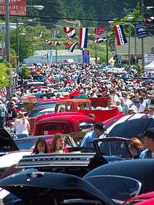
The city has a large number of events and festivals including the Daffodil Festival, Art & Wine in the Park, the Annual Fortuna Rodeo, the Redwood AutoXpo, the Logging Competition, Civil War Days, and Apple Harvest, the Hops in Humboldt festival, the Fortuna Concert Series and holiday events including concerts and parades with performances by Scotia Band Brass Choir and Saxophone Quartet.[21] Additionally, the Eel River was the locale for the Paddle to the Headwaters canoe race.
Notable residents
- Jean Buckley, center fielder in the All-American Girls Professional Baseball League
- John A. Campbell, timber executive and president of the Pacific Lumber Company
- Reggie Christiansen, American college baseball coach
- Chester Dunning, professor of Russian and European history at Texas A&M University
- Cecelia Holland, historical novelist
- Sam Reynolds, professional soccer player
- Ryan Villopoto, professional supercross and motocross champion
- Randy Niemann, major league baseball player, major league baseball coach
References
- ↑ "Fortuna, CA - Official Website". Friendlyfortuna.com. Retrieved 2013-10-25.
- ↑ "California Cities by Incorporation Date" (Word). California Association of Local Agency Formation Commissions. Retrieved April 7, 2013.
- 1 2 "City Council". Fortuna, CA. Retrieved April 7, 2013.
- ↑ "2010 Census U.S. Gazetteer Files – Places – California". United States Census Bureau.
- ↑ "Fortuna". Geographic Names Information System. United States Geological Survey.
- 1 2 3 Durham, David L. (1998). California's Geographic Names: A Gazetteer of Historic and Modern Names of the State. Clovis, Calif.: Word Dancer Press. p. 62. ISBN 1-884995-14-4.
- ↑ "Language – Wiyot Tribe". Retrieved 2012-07-07.
- 1 2 3 4 The Road to the Friendly City: A Brief History of Fortuna, Sunny Fortuna, 2013
- 1 2 3 Lynwood Carranco (1 March 1986). Redwood Country. Star Publishing Company. ISBN 978-0-89863-097-8.
- 1 2 The Fortuna Electric Light Works, Sunny Fortuna, 2013
- ↑ Stindt, Fred A. (1978). The Northwestern Pacific Railroad: Redwood Empire Route (3rd ed.). Kelseyville, California: Fred A. Stindt. pp. 40–41,126&136. ASIN: B0007F4A2M.
- ↑ Fortuna, The Friendly City!, Sunny Fortuna, 2013
- ↑ "Annual Estimates of the Resident Population for Incorporated Places: April 1, 2010 to July 1, 2015". Retrieved July 2, 2016.
- ↑ "Census of Population and Housing". Census.gov. Retrieved June 4, 2015.
- ↑ "2010 Census Interactive Population Search: CA - Fortuna city". U.S. Census Bureau. Retrieved July 12, 2014.
- ↑ "American FactFinder". United States Census Bureau. Retrieved 2008-01-31.
- ↑ City of Fortuna CAFR Archived March 6, 2012, at the Wayback Machine.
- ↑ "Senators". State of California. Retrieved 10 March 2013.
- ↑ "Members Assembly". State of California. Retrieved 2 March 2013.
- ↑ "California's 2nd Congressional District - Representatives & District Map". Civic Impulse, LLC. Retrieved March 1, 2013.
- ↑ "Fortuna Events & Festivals". Sunny Fortuna. 2013.
| Wikimedia Commons has media related to Fortuna, California. |