Englewood, California
Not to be confused with Inglewood, California.
Coordinates: 40°23′48″N 123°56′20″W / 40.39667°N 123.93889°W
| Englewood | |
|---|---|
| Unincorporated community | |
 Englewood  Englewood Location in California | |
| Coordinates: 40°23′48″N 123°56′20″W / 40.39667°N 123.93889°W | |
| Country | United States |
| State | California |
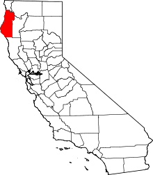
| County | Humboldt County |
| Elevation[1] | 364 ft (111 m) |
Englewood (formerly, Englevale)[2] is an unincorporated community in Humboldt County, California.[1] It is located 0.5 miles (0.8 km) east-southeast of Redcrest,[2] at an elevation of 364 feet (111 m).[1] The area is the site of a few homes and a derelict Eel River Sawmills mill.
Englewood post office operated from 1880 to 1891.[2] The Englevale post office operated from 1893 to 1894.[2]
References
This article is issued from Wikipedia - version of the 7/5/2016. The text is available under the Creative Commons Attribution/Share Alike but additional terms may apply for the media files.