Cherthala
| Cherthala ചേർത്തല | |
|---|---|
| Taluk | |
| Coordinates: 9°41′13″N 76°20′10″E / 9.68694°N 76.33611°ECoordinates: 9°41′13″N 76°20′10″E / 9.68694°N 76.33611°E | |
| Country | India |
| State | Kerala |
| District | Alappuzha district |
| Government | |
| • MLA (2011-16) |
Mr. Tilothaman (M.L.A Cherthala) Adv. A.M. Arif (M.L.A. Aroor) |
| Area | |
| • Total | 187.43 km2 (72.37 sq mi) |
| Elevation | 0 m (0 ft) |
| Population (2011) | |
| • Total | 45,827 |
| • Rank | 11 (Cherthala Urban Agglomeration) |
| • Density | 1,612/km2 (4,180/sq mi) |
| Languages | |
| • Official | Malayalam, English |
| Time zone | IST (UTC+5:30) |
| PIN | 688524 |
| Telephone code | 0478 |
| Vehicle registration | KL-32 or KL-04 |
| Sex ratio | 1030 ♂/♀ |
| Lok Sabha constituency | Alappuzha |
| Vidhan Sabha constituency | Cherthala and Aroor |

Cherthala (formerly Shertallai or Shertallay) is a town located in the district of Alappuzha, in the state of Kerala, India. It is 31 km to Kochi and Kottayam and 22 km north of Alappuzha town, on the Kochi-Alappuzha National Highway NH 47, as well as the coastal rail route. The coastal town is also about 20 kilometers from the historical town of Vaikom and the popular tourism destination Kumarakom.

In local administration, the Cherthala town is a municipality while in the state administrative structure Cherthala is a taluk in the district of Alappuzha. The Corporation of Cochin has drafted a master plan that aims to develop Cherthala as the satellite town around Kochi.
Etymology
According to the local legend, once Vilwamangalam Swamiyar, the well known Kerala Hindu saint, while travelling through Cherthala, found an idol of the Devi with its head immersed in a muddy pond. The swami understood the divinity of the idol, took it out of the mud, cleaned it and consecrated it in a temple near the pond. Thus the place is believed to have gotten its name as cher meaning "mud" and thala meaning "head" in Malayalam. The deity of the temple has the name Cherthala Karthiyayani.[1] The word put together means "head from the mud". Unlike in other Kerala temples, the idol of Cherthala Karthiyayani Devi is consecrated in the Sreekovil just below the ground level and cannot be directly viewed by the devotees.
There is another story that says that the former name was Karappuram and that this piece of land was given by the erstwhile State of Cochin to the erstwhile state of Travancore for protecting it from enemies. The place got its name as chertha ("joined") thala ("abutting land").
Climate
| Climate data for Cherthala, Kerala | |||||||||||||
|---|---|---|---|---|---|---|---|---|---|---|---|---|---|
| Month | Jan | Feb | Mar | Apr | May | Jun | Jul | Aug | Sep | Oct | Nov | Dec | Year |
| Average high °C (°F) | 31.8 (89.2) |
32.0 (89.6) |
32.6 (90.7) |
32.7 (90.9) |
29.4 (84.9) |
28.8 (83.8) |
28.8 (83.8) |
29.3 (84.7) |
29.3 (84.7) |
29.9 (85.8) |
30.5 (86.9) |
31.3 (88.3) |
30.53 (86.94) |
| Average low °C (°F) | 22.4 (72.3) |
23.4 (74.1) |
24.8 (76.6) |
25.5 (77.9) |
25.1 (77.2) |
23.8 (74.8) |
23.2 (73.8) |
23.5 (74.3) |
23.6 (74.5) |
23.7 (74.7) |
23.7 (74.7) |
22.7 (72.9) |
23.78 (74.82) |
| Average precipitation mm (inches) | 25 (0.98) |
39 (1.54) |
56 (2.2) |
146 (5.75) |
351 (13.82) |
705 (27.76) |
621 (24.45) |
392 (15.43) |
297 (11.69) |
317 (12.48) |
199 (7.83) |
53 (2.09) |
3,201 (126.02) |
| Source: Climate-Data.org[2] | |||||||||||||
Local governance
Cherthala taluk is a part of Alappuzha Revenue District and Alappuzha Parliamentary constituency. All the villages of Cherthala Taluk come under the Cherthala and Aroor Constituencies of Kerala Legislative Assembly. The three-tier local governance structure is as follows: Cherthala Taluk area comes under Alappuzha district panchayat and the area is divided into three block panchayats: Pattanakad, Thycattuserry and Kanzhikuzhy. These block panchayats are again subdivided into Grama panchayats. The Grama panchayats in Pattanakkad Block Panchayath are Aroor, Ezhupunna, Kuthiathode, Kodamthuruthu, Thuravoor, Pattanakad and Vayalar. The Thycattussery Block Panchayath have five Grama Panchayaths, viz., Arookutty, Perumbalam, Panavally, Thycattusserry and Chennam Pallippuram. Kadakarapally, Cherthala South, Kanjikuzhi, Thanneermukkom and Mararikulam North are Grama panchayaths in the Kanjikuzhi block.
Demographics

According to the Kerala government website, Cherthala municipality had a population of 43,326 over an area of 16.18 square kilometres (6.25 sq mi). The density of the population is 2678 per square kilometre. Males constitute 49% of the population and females 51%.[3]
Cherthala has an average literacy rate of 94%, with male literacy of 98.4% and female literacy of 89.7%.
Places of worship
- Varanadu Devi Temple www.varanattamma.com/mainofferings.php
- St. Mary's Forane Church, Muttom, Cherthala P O,
- St. Mary's Forane church , Pallippuram
- St. Andrew's Basilica Church (Arthunkal palli), Arthinkal- 8 km southwest from town on Cherthala-Thumboly-Alappuzha road
- St. Mary's Forane Church, Thankey -5 km north from Town on Cherthala-Thanky-Anthakaranazhi road
- St. Martín de Porres Church, Vadakkumuri- 2 km west from town near Kizhekkenalpathil
- Karthayayani Devi Temple, at the heart of Chertala town
- Kandamangalam Sree Rajarajeshwari Temple, Kadakkarappally.
- Kuttikattu Sree Bhadra Kali Devi Temple
- Maruthorvattom Sree Dhanvanthri Temple, Maruthorvattom
- Kanichukulangara devi temple, Kanichukulanghara
- Thuravoor Narashimha Moorthy-Sudharshana Moorthy Mahakshethram, Thuravoor, 12 km North of town on NH 47
- Thuravoor Tirumala Devasom Lakshmi Narasimha Temple, Thuravoor
- Chammanad Devi Temple, Chammanad
- Thiruayranikkulam Kalathil Mahadeva temple Pallippuram
- Vellimuttam Sreedhrma Sastha Temple
- Cherthala Town Central Juma Masjid, Near Manorama Kavala, Cherthala
- Rifayi Juma Masjid, Nedumbarakad, Cherthala
- Kattupuram Palli Juma Masjid, Vaduthala Jetty
- Kottupram Palli Juma Masjid, Arookutty
- Hidayathul Islam Masjid, Hidayath Jn., Vaduthala Jetty
Educational organizations
- College of Engineering, Cherthala
- Nair Service Society College
- Sree Narayana College
- St. Michael's college
- KVM College of Engineering & Information Technology
- SNGM Institutions - Valamangalam, Thuravoor
Drama and theater troupes
- Cherthala Jubilee Theatres - run by the late Rajan P. Dev
- S.L. Puram Suyrasoma Theatres
Karnatic music
Perhaps inspired by its illustrious son, Irayimman Thampi, Cherthala has a community of Karnatic music connoisseurs, especially performers, in the older generation as well in the younger generation. Well-known Karnatic singers and instrumentalists include Cherthala Gopalan Nair, Thiruvizha Jayasankar, Nedumangad Sivanandan, Thiruvizha Sivanandan, Cherthala K. Narayana Iyer and Cherthala Ranganatha Sarma. Many of the senior artists also have a significant number of disciples in and around Cherthala.
Industries
Inland waterway
Cherthala lies between the Kottapuram-Kollam National Waterway 3 passing through the Vembanad lake. Prior to the coming of NH 47, cargo and freight from Cochin market were transported in country boats through the Vembanad lake via the small lake diverting from Arukutty-Thycattuserry-Vayalar. Now these country boats are no more used for cargo transportation, instead converted into tourist floating houseboats. One can still find the canal running across the center of the town which was once the busiest waterway. One can reach Vaikom by the Tavankadav-Vaikom ferry service covering approx 3.5 km across the Vembanad lake and joining the Kottayam district at Vaikom jetty. There are small inland waterways or rivers, which flow across the villages, still navigable through county boats. They transport coir, marine products, vegetables, paddy, sand, construction materials, etc. where roads are inaccessible. The majority of these inland rivers flow from Vembanad Lake on the eastern side and merge into the azhi or sea near Anthakaranazhi on the west coast, crossing the NH 47 at different places.
Landmarks
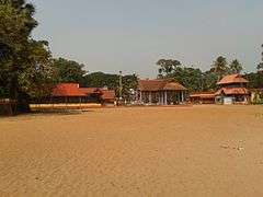
Cherthala Town Municipality has 32 wards.[4] The town is well known after the Karthyayani Devi temple, located in the center of the town. Two more sub-temples dedicated to Shiva and Vishnu are also located on the northern side of the main temple. A sub-temple dedicated to Lord Ayyappa, also known as Kaavudayan and another dedicated to Kshethrapalakan believed to be Devi's temple caretaker are located on the southern corner of the main temple. Thousands of devotees coming from different 'karas' (localities) of Cherthala participate in the Padayani, vela thullal and pooram pattu, the main rituals conducted during the temple festival. A large pond exists in front of the Taluk office that belongs to the Karthyayani Devi temple. One can see many roosters flocking around the temple premises. These roosters are the offerings of the devotees, an ancient custom followed in many devi temples of Kerala. The temple is administered by Travancore Devaswom Board.

Another temple in Cherthala town is the Muttathu Thirumala Devaswam temple. Lord Narasimha presiding in the form of Saligrama and Sree Venkatachalapathy Moorthy with bhoo devi and sree devi are the deities of this temple. The temple conducts its annual festival either ahead of the Karthyayani Devi's festival or soon after that. The Pallivetta is a procession where it is believed that Goddess is going for the divine hunting. The annual festival lasts for eight days.
Notable people
- V.V.Babu- Film producer. Made several land mark movies in Malayalam like Thakara(1979),Venkalam,chakoram,Agnisaakshi,etc. He has been recognised for his contributions with state an national awards.
- Nangeli - Dalit woman who fought against social injustice
- Irayimman Thampi - Carnatic musician as well as a music composer from Kerala
- Vayalar Ramavarma - Malayalam poet and film lyricist
- Cherthala Bhavani Amma - famous Harikadha artist known as "Harikadhayude muthassi"
- A. K. Antony - thrice Chief minister of Kerala in UDF Ministry, Indian Defence Minister
- Vayalar Ravi - former Home minister of Kerala in UDF Ministry, Union Cabinet Minister of Overseas Indian Affairs and Minister for Parliamentary Affairs
- S. D. Shibulal - Chief Executive Officer and Managing Director of Infosys
- Prasanth Parameswaran - Kerala First class cricketer, Indian Premier League Royal Challengers Bangalore Player
- Jomon T. John - Indian cinematographer
- Ratheesh - Malayalam film actor
- Vellapally Natesan - General Secretary of SNDP Yogam
- Navajyothi Sree Karunakara Guru - founder of Santhigiri Ashram
- K. R. Gowri Amma - Revenue Minister in the first Kerala LDF ministry, initiated the revolutionary land reforms in Kerala, Agriculture minister in Kerala UDF Ministry
- PS Karthikeyan - former Secretary, S.N. Trust, Former Director of SNDP Yogam, Former Member of the Legislative Assembly - Aroor, Chief Editor of Dinamani daily
- P. Parameswaran - Director, Bharatheeya Vichara Kendram
- Jagannatha Varma - Kathakali artist, actor in Malayalam film and serial
- Nedumangad Sivanandan - renowned Karnatic Violinist and teacher
- Rajeev Alunkal - film lyricist and poet
- Vayalar Sarath Chandra Varma - film lyricist
- Riaz M T - Malayalam film actor
- Rajan P. Dev - Malayalam film actor and drama/theater personality
- S. L. Puram Sadanandan - Malayalam playwright and film scriptwriter
- Chelangatt Gopalakrishnan - writer and film critic
- Joy J. Kaimaparamban - English and Malayalam author
- Itty Achudan - major contributor of ethno-medical information for the compilation of Hortus Malabaricus
- Palackal Thoma Malpan - founder of the Carmelites of Mary Immaculate
- Mgr. Joseph C. Panjikaran - founder of the Medical Sisters of St. Joseph
- P. J. Thomas, Polayil - Chief Secretary, Kerala
- Anoop Chandran - Malayalam cine actor
- Radhika - Malayalam cine actress
- Vayalar Baburaj - kathaprasangam (story telling) artist
- C. K. Chandrappan - communist leader
References
- ↑ Namboothiri Websites Calicut (3 October 2003). "Vilwamangalam Swaamiyaar". Namboothiri.com. Retrieved 2013-03-04.
- ↑ "CLIMATE: CHERTALA", Climate-Data.org. Web: .
- ↑ Panchayat Statistics 2001 Archived 30 September 2007 at the Wayback Machine.
- ↑ http://www.cherthalamunicipality.in Cherthala Municipality
External links
| Wikimedia Commons has media related to Cherthala. |
|
