Kattappana
| Kattappana കട്ടപ്പന | |
|---|---|
| Municipality | |
|
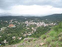
A distant view of Kattappana town | |
 Kattappana  Kattappana Location in Kerala, India | |
| Coordinates: 09°45′15″N 77°06′57″E / 9.75417°N 77.11583°ECoordinates: 09°45′15″N 77°06′57″E / 9.75417°N 77.11583°E | |
| Country |
|
| State | Kerala |
| District | Idukki |
| Named for | Spices |
| Government | |
| • Type | Municipality |
| • Body | Kattappana municipality |
| • Municipal Chairman | Johny Kulampally |
| Area | |
| • Total | 52.77 km2 (20.37 sq mi) |
| Elevation | 1,100 m (3,600 ft) |
| Population (2011)[1] | |
| • Total | 42,646 |
| • Density | 993/km2 (2,570/sq mi) |
| Languages | |
| • Official | Malayalam, English |
| Time zone | IST (UTC+5:30) |
| PIN | 685508 (Kattappana), 685515 (Kattappana south) |
| Telephone code | 04868 |
| Vehicle registration |
KL-06 (Idukki) KL-37 (Vandiperiyar) KL-69 (Udumbanchola) |
| Nearest cities | Kumily, Nedumkandam |
| Literacy | 92% |
| Lok Sabha constituency | Idukki |
| Sex ratio | 1016 ♂/♀ |
| Website | |
Kattappana is a fast growing municipality in the Sahyadri (or Western Ghats) of Kerala state, India. It is the main urban centre in the high ranges of Idukki district, situated about 3,600 feet (1,100 m) above mean sea level, in the High Ranges, the high altitude region of Kerala has recently raised to the status of municipality. Kattappana is a CLASS III urban centre. It is the first municipality in high range of Idukki district with the real terraineous touch of Idukki as Thodupuzha municipality is situated in low range. It is a major commercial town and flourished with the boost in production of agriculture and spices. Based on the 2011 Census, it had a total population of 42646, consisting of 21,159 males and 21,487 females.[1]
People migrated to this place mainly during 1950s from different parts of nearby townships like Palai, Kottayam etc. However, there were inhabitants even before 100 years. The main occupation was cultivation of commercial crops and spices like Tea, Coffee, Pepper, Cardamom, Black Pepper etc., and the majority of them are farmers.[2] One of the anchor institutions in Kattappana is St. John's Hospital. When it was started in 1968, it was one of the main hospitals in a 100-km radius. Managed by the Hospitaller Brothers of St. John of God, the hospital has grown to a tertiary level of 450 - bedded multi-speciality hospital with sixteen clinical disciplines. Even today, it is the only tertiary level referral center in this area.[3]
Administration
Previously Kattappana was included in the Udumbanchola taluk of Idukki district and was later included in the newly formed Idukki taluk. It is the second municipality in the district, while Thodupuzha being the first one.
Wards in Kattappana municipality

For administrative convenience, the municipality is divided into 34 wards. The current municipal chairperson is Jhony Kulampally.
|
|
Etymology
It is believed that the name Kattappana derived from the Malayalam word "Koottappana" (Kootta means a group and Pana means palm tree) which later became Kattappana.
Demographics
It is one of the more important commercial centre in the high ranges and was on a fast track in terms of development and infrastructure building. Kattappana became a grama panchayat in 1962 and the first panchayat council under the presidency of V.T. Sebastian was formed in 1964.
However, it was the development of the Kottayam–Kattappana road and the Puliyanmala–Thodupuzha State highway that turned the town into a commercial centre. It was the agriculture sector that played a pivotal role in economically uplifting the town
According to 2011 Census, the population was 42,646, with 21,159 males and 21,487 females. The population in the age group 0–6 years are 4,412. The Scheduled Castes (SC) were 2,585 and the Scheduled Tribes (ST) were recorded as 524. The number of literates are 36,418 with the average literacy rate at 95.25%.[1]
The town had a large population of Syrian Catholic families who migrated to Kattappana in early 1950s from Central Travancore.[4] The migrations were majorly from Palai, Chenganassery and Kanjirapally taluks of Kottayam district and Pathanamthitta. Apart from the Catholics, the Nadar, Viswakarma, Nair, and Ezhava communities also make up a good part of the population. The landmark of the town is an edifice dedicated to Narayana Guru. There are also Muslim families and the Juma Masjid caters to their religious needs.
Descendants of earlier inhabitants, the tribals of the forest, can still be seen. The Mannan tribe is now concentrated around Kovilmala, near Kanchiyar.[5] Before large scale migration and settlement took place in Kattappana and surrounding areas in early 1950s, there were Tamil farmers. There is a sizable number of Tamil labor force forming part of the floating population of Kattappana.
Agriculture


Kattappana is the center for spices trade and the primary producer of cardamom[6] and black pepper. The main occupation of people of Kattappana is agriculture. A specific type Njallani high yielding variety of cardamom, was developed in Kattappana. It is also the centre of production and marketing of coffee, cocoa and ginger. There are also several reputed tea plantations (Tata Tea, A V Thomas & Co, Malayalam Plantations, Kannan Devan etc.) in adjoining areas of the district.
Spices Board (erstwhile Cardamom Board under Government of India) has an office in Kattappana. A Spices Park is established at Puttadi near Kattappana. Cardamom Research Institute is situated at Pampadumpara.
Njallani high yielding variety of cardamom was developed by Sebastian Joseph Njallani of Kattappana, who migrated to Kattappana in 1952.[7]
Tourism

Tourism thrives in the rural areas of Kattappana. The main tourist attractions are Thekkady, Kumili, Idukki and Munnar. Calvari Mount (Kalyanathandu) and Anchuruli are also famous tourist spots. A scenic view of Idukki dam, which is a part of the largest hydro-electric project in the state of Kerala, is visible from Kattappana. Calvari Mount (Kalyanathandu) has a bird's eyes view of the reservoir from 200 metres above the reservoir. Within 17 km we can reach Ramakkalmedu in Thookkupalam.
Climate
The climate of Kattappana falls under the Köppen climate classification. The palace normally experiences a moderate climate. The humidity rises from the month of March to April and mid May. The average annual temperature here is 23°C. The months of June, July, August and October receives significant amount of rainfall. November and December are the coldest months in the year.
| Climate data for Kattappana, Kerala | |||||||||||||
|---|---|---|---|---|---|---|---|---|---|---|---|---|---|
| Month | Jan | Feb | Mar | Apr | May | Jun | Jul | Aug | Sep | Oct | Nov | Dec | Year |
| Average high °C (°F) | 26.1 (79) |
27.4 (81.3) |
29.1 (84.4) |
29.3 (84.7) |
29.2 (84.6) |
27.2 (81) |
26.1 (79) |
26.5 (79.7) |
26.8 (80.2) |
26.2 (79.2) |
25.5 (77.9) |
25.5 (77.9) |
27.08 (80.74) |
| Average low °C (°F) | 16.8 (62.2) |
17.5 (63.5) |
19.0 (66.2) |
20.2 (68.4) |
20.8 (69.4) |
20.1 (68.2) |
19.6 (67.3) |
19.6 (67.3) |
19.3 (66.7) |
19.1 (66.4) |
18.5 (65.3) |
17.2 (63) |
18.97 (66.16) |
| Average precipitation mm (inches) | 22 (0.87) |
30 (1.18) |
52 (2.05) |
116 (4.57) |
163 (6.42) |
307 (12.09) |
396 (15.59) |
246 (9.69) |
163 (6.42) |
252 (9.92) |
176 (6.93) |
75 (2.95) |
1,998 (78.68) |
| Source: Climate-Data.org[8] | |||||||||||||
Infrastructure
Raising of Kattappana Panchayat into a municipality paves the way for developmentioned of the town. Kattappana is changing its face with multi-storey buildings, developed roads and rated facilities. Kattappana is presently a new aim of some MNC and hospitality sector. Like all developing towns in Kerala, Kattappana is also facing stiff traffic congestion due to absence of a well defined road network.
Landmarks
- St. John's Hospital.
- Calvari Mount (Kalyanathandu) View Point
- Government higher secondary school
- Government college Kattappana
- Anchuruli tunnel and Idukki reservoir
- College mala, Nariyampara
- ST.George forane church Kattappana
- ST.Jeromes H.S.S Vellayamkudi[9]
- Sri Dharma Sastha temple
- Gurumandhiram, Kattappana
- INFANT Jesus residential school
- Cardamom research centre Pampadumpara
Educational institutions
Schools
- St.George H.S.S
- St.Jeromes H.S.S Vellayamkudi
- St.Thomas H.S.S Erattayar
- Mannam memorial high school Nariyampara
- Auxilium ICSE school
- Infant Jesus residential school
- Ossanam H.S.S
- Saraswathi Vidaya peedam
- Zion public school, swaraj
- De Paul international residential school, Udayagiri, Kattappana
- Montfort Senior Secondary School Anakkara,
- GOVT HSS,Kattappana,
Colleges
- Jawaharlal Nehru Institute of Arts & Science (JNIAS) , Thookkupalam, Balagram P.O
- Government college Kattappana
- Government I.T.I Kattappana
- College of applied sciences - I.H.R.D college
- John Paul memorial college, Lebbakkada
- Christ college, Kattappana
- St.Sebastian college
- St.John's nursing college
- Pavanathma college Murikkassery
Tourist attractions
- Anchuruli tunnel and Idukki reservoir
- College mala at Nariyampara where remains of old college can be seen.
- Kalyanathandu view point of 360°angle, mainly Idukki reservoir view.
- Kalvarimount view point, another view of Idukki reservoir.
- Kovilmala, Kerala's one and the only kingdom of tribal population situated in this place.
- Ayyappankovil suspension bridge and old Dharmasastha temple.
- Ramakkalmedu view point of Tamil Nadu and statue of Kuravan and breastfeeding Kurathi.
Filming locations
- Kattappana town
- Anchuruli tunnel and Idukki reservoir - 9 km
- Kalyanathandu view point - 3 km
- Ayyappankovil suspension bridge and the old temple - 14 km
- Kalvarimount view point - 10 km
Transportation
Kattappana has a well established road system to other districts as well as to nearby state Tamil Nadu. Recently one new National highway 185 announced to Idukki district, through Adimali-Cheruthoni-Kattappana-Kumily.
Night bus services
- Daily Kattappana to Bangalore service
- Daily Kattappana to Chennai service
- Daily Kattappana to Thiruvananthapuram service
- Daily Kattappana to Kannur service
Distances to nearby towns
- Nedumkandam - 25 km
- Kumily - 30 km
- Elappara - 32 km
- Cumbum -30 km
- Palai - 77 km
- Thodupuzha - 90 km
References
- 1 2 3 "Kattappana population". The Registrar General & Census Commissioner, India. Retrieved 30 June 2014.
- ↑ "'Trial Run Begins at Spices Park'". The Hindu. Retrieved 30 June 2014.
- ↑ "St. John's Hospital website". Retrieved August 17, 2016.
- ↑ St George Forane Church, Kattappana
- ↑ Mannan tribe
- ↑ Cardamom Cultivation
- ↑ "Tale of an Indigenous Farmer", Rediff.com
- ↑ "CLIMATE: KATTAPANA", Climate-Data.org. Web: .
- ↑ vellayamkudychurch.org
External links
| Wikimedia Commons has media related to Kattappana. |