Anthoor
| Anthoor | |
|---|---|
| Municipality | |
|
Parassinikkadavu Sree Muthappan Temple | |
| Coordinates: 11°59′13″N 75°22′34″E / 11.987°N 75.376°ECoordinates: 11°59′13″N 75°22′34″E / 11.987°N 75.376°E | |
| Country |
|
| State | Kerala |
| District | Kannur |
| Taluka | Taliparamba |
| Government | |
| • Body | Municipal Council |
| Area | |
| • Total | 28.44 km2 (10.98 sq mi) |
| Population (2011) | |
| • Total | 36,290 |
| • Density | 1,276/km2 (3,300/sq mi) |
| Languages | |
| • Official | Malayalam, English |
| Time zone | IST (UTC+5:30) |
| PIN | 670331, 670562, 670563, 670564, 670567. |
| Telephone code | 497278**** |
| ISO 3166 code | IN-KL |
| Vehicle registration | KL-13, KL-59 |
| Sex ratio | 1121 ♂/♀ |
| Literacy | 93.45% |
| Lok Sabha constituency | Kannur |
| Vidhan Sabha constituency | Taliparamba |
| Civic Agency | Municipality |
| Climate | pleasant (Köppen) |
| Website | |


Anthoor (Malayalam: ആന്തൂർ നഗരസഭ) is a Municipality in the Kannur district of North Malabar region in the Indian state of Kerala. Anthoor is located around 14 km from Kannur Corporation and it is adjacent with Taliparamba Municipality.[1][2]
Demographics
As of 2011 India Census, Anthoor had a population of 36290, with 17,154 males and 19,136 females.[3]
Anthoor was a Panchayath consisting of two tiny villages viz. Morazha and Anthoor. In 1990, when Govt of Kerala announced new Municipalities, Anthoor Panchayat was merged with Taliparamba to form a new Municipality of Taliparamba.[4] Later in 2015 the Govt separated Anthoor from Taliparamba and made it an independent Municipality. Anthoor is a Municipality by its population and density but remain with the characteristics of a beautiful village. Its tucked on NH-17, situated near Taliparamba in Kannur District of North Malabar region in Kerala. [1][2]
Etymology
The name Anthoor means large village. Due to its large size, it was split in to two i.e. Anthoor and Morazha. The hill of Anthoor has been mentioned in many Theyyam folk songs/Thottam Pattu (തോറ്റം പാട്ട്).[5]
History
During Kolathiri rule, Anthoor was under them. Later, Tipu Sultan adjoined this area as part of Kingdom of Mysore. During British Raj this place was under Chirakkal Taluk of Malabar District in Madras Presidency. After formation of Kerala State this area was made as a Panchayat in Cannanore District. Later the Anthoor Panchayat was merged with Taliparambu Municipality upon later's formation. Presently Anthoor is an independent Municipality of Kannur District of Kerala State.[6][7][8]

Culture and geography
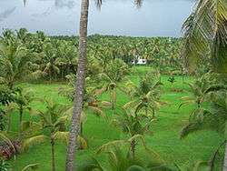
- Almost 1/2 of its geographical border is surrounded by two rivers i.e. Valapattanam Puzha and Kuttikkol Puzha. There are very beautiful scenic spots in the banks of these rivers. The backwaters at Vellikkeel is a fabulous tourist spot and is a notified Eco-Tourism Area.
- Anthoor Municipality shares borders with Taliparamba and Kurumathur to the north, Kalliasseri and Aroli south, Kannapuram to the west, Mayyil, Kolacherry and Narath to the east.[9][10][11][12][13][14][15]

Famous Institutions in Anthoor
The popular Institutions as well as significant Areas of Anthoor Municipality (ആന്തൂർ നഗരസഭ) are:
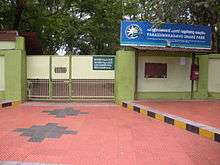
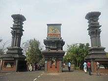
- Parassinikkadavu
- Muthappan Temple
- Institute of Co-operative Management[16]
- Vismaya Infotainment Park
- Snake Park
- Parrasianikkadavu Ayurveda Medical College[15]
- Mangattuparambu
- Doordarshan Station
- Kannur Engineering College[10]
- Dharmashala
- National Institute of Fashion Technology, Kannur[14]
- Kendriya Vidyalaya Keltron Nagar[17]
- KELTRON, Kannur
- KAP 4 Battalion, Kannur
- Kerala Clays and Ceramic Products Limited
- Kannur University Main Campus[11]
- Vellikkeel Eco Tourism Park
- Punnakkulangara
Administration
- District: Kannur
- Taluk/Tehsil: Taliparamba
- Block: Taliparamba
- Assembly constituency: Taliparamba
- Police Station: Taliparamba
- Post Offices & PIN :
- 1. Anchampeedika-670331,
- 2. Morazha-670331,
- 3. Kanool-670562,
- 4. Kuttikkol-670562,
- 5. Parassinikkadavu-670563,
- 6. Nanicheri-670564,
- 7. Kannur University Main Campus-670567,
- 8. Keltron Nagar-670567
- Telephone Exchange: Mangattuparambu (0497)
- Municipal Office Contact : 2780555
- Nearest Railway Stations: Kannapuram
Educational organizations
- Govt College Of Engineering
- National Institute of Fashion Technology
- Institute of Co-operative Management
- Kannur University College
- Morazha Arts and Science College
- Parassinikkadavu Higher Scondary School
- Central School Mangattuparamba
- Morazha Higher Secondary School
- Ozhacrome School
Major industries
The major industries are:
- Fibre Foam
- Plywood
- KINFRA Mangattuparamba
- KSIDC Mangattuparamba
- Handweave
- Vegetables and milk marketing
- Paddy Fields of Morazha and Kanool
Politics
Anthoor is always 100% CPIM Supporting Area. Many of the Councillors are elected unopposed.[18]
Anthoor Municipality
|
Transportation
The national highway passes through Dharmashala junction. Mangalore and Mumbai can be accessed on the northern side and Cochin and Thiruvananthapuram can be accessed on the southern side. The road to the east connects to Mysore and Bangalore. The nearest railway stations are Kannapuram and Kannur on Mangalore-Palakkad line. There are airports at Mangalore and Calicut.
Municipal Wards
- VELLIKKEEL - 1
- MORAZHA -2
- KANOOL - 3
- MUNDAPRAM - 4
- MAYILAADU - 5
- BAKKALAM - 6
- PEELERY - 7
- AYYANKOVIL - 9
- KADAMBERY - 9
- KOLMOTTA - 10
- NANICHERY - 11
- KODALLUR - 12
- MAMBALA - 13
- PARASSINI - 14
- KOVVAL -15
- ANTHOOR - 16
- THALIYIL - 17
- PODIKKUND - 18
- THALIVAYAL - 19
- DHARMASHALA - 20
- PUNNAKULANGARA - 21
- KUTTIPRAM - 22
- C H NAGAR - 23
- OZHACROM - 24
- ANCHAMPEEDIKA - 25
- VENIYIL - 26
- PALIYATHVALAPPU - 27
- PANNERI - 28.[21]
References
- 1 2 "New Municipalities of Kerala : Election Results". Trend Kerala - Democracy. Retrieved 2016-03-20.
- 1 2 "Kannur.gov.in : Villages of Kannur District". Retrieved 2010-07-07.
|first1=missing|last1=in Authors list (help) - ↑ http://www.censusindia.gov.in/2011census/dchb/3202_PART_B_KANNUR.pdf
- ↑ http://www.taliparambamunicipality.in/about
- ↑ http://www.keralatourism.org/routes-locations/anthoor/id/804
- ↑
- ↑
- ↑
- ↑ "Kannur District Map : Villages of Kannur". Retrieved 2010-07-07.
|first1=missing|last1=in Authors list (help) - 1 2
- 1 2
- ↑
- ↑
- 1 2
- 1 2
- ↑
- ↑ http://www.kvkeltronnagar.com
- ↑ "Panchayat Elections Kerala". Kerala. Election Commission of India. Retrieved 2016-03-19.
- ↑ http://www.lsgkerala.gov.in/pages/memberDetails.php?intID=3&ID=1287&ln=en&candid=2015128700201
- ↑ http://nocorruption.in/politician/james-mathew/
- ↑ http://www.lsg.kerala.gov.in/pages/electiondetails.php?intID=3&ID=1287&ln=en