Haripad


| Haripad ഹരിപ്പാട് | |
|---|---|
| town/municipality | |
 Haripad  Haripad Location in Kerala, India | |
| Coordinates: 9°18′0″N 76°28′0″E / 9.30000°N 76.46667°ECoordinates: 9°18′0″N 76°28′0″E / 9.30000°N 76.46667°E | |
| Country |
|
| State | Kerala |
| District | Alappuzha |
| Government | |
| • Body | Municipality |
| • MLA | Ramesh Chennithala |
| Population | |
| • Total | 30,977 |
| Languages | |
| • Official | Malayalam, English |
| Time zone | IST (UTC+5:30) |
| PIN | 690514 |
| Telephone code | +91479 |
| Vehicle registration | KL- 29 |
| Nearest city | Alappuzha |
| Lok Sabha constituency | alappuzha |
| Website |
www |
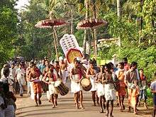
Haripad (Malayalam:ഹരിപ്പാട് ) is a Municipality in Alappuzha District, Kerala, India located between Alappuzha and Kollam on the National Highway 66. Its coordinates are Latitude : 9°18′0″N and Longitude : 76°28′0″E. It is bordered on the east by Pallippad, Veeyapuram and Karuvatta to the north, Kumarapuram and Mahadevikadu to the West, and on the south by Nangiarkulangara.[1] Haripad is close to the Arabian Sea and connects Mavelikara and Thrikkunnappuzha. It is known as the land of art, artists, land of snake boats, land of music, dance and drama. A main feature of Haripad which attracts even the foreigners is the "Payippad Jalolsavam". It is believed that the currently worshiping idol of Lord Subrahmania was brought from Kandalloor with escort of snake boats and Valla Sadya. .[2]
Haripad derived its name from either Aripad (Ari meaning Rice), or "Harigeethapuram".[3] The population of Haripad is 16,445, as of the 2010 census.[4]
History
In ancient time Buddha religion was flourished in this area. It is said that ancient Buddha university SREEMOOLAVASAM was located at Thrikkunnappuzha ,the coastal area of Haripad. Evidence for Buddha religion can be seen as Buddha statue of Mavelikara., Banyan trees of temples paramparya vaidyas. There is a statue of a woman and child with sasthav of Thrikkunnapuzha temple. It is considered that they are Yasodharaand Rahulan respectively .The name Haripad is only in the 20 th century Before that it was Arippatt. Some scholars say that it means place near water(ari- arike pat place0 During the period of European colonization, In the opinion of the Dutch Governor Gollanez the sea coast between Quilon and Purakkad which the Dutch called 'Martha" and which region was known as Karthikappally consisted of two regions or nation states, Karnoppally (present-day Karunagapally) and Karimpali.[5][6] More specifically, Haripad was located in Karimpali which was the area between Kayamkulam and Purakkad and was also known as Vettimana.
The capital of Vettimana was Karimpalil palace (near the present-day Haripad Railway Station), but at some point it was moved to Karthikappally. In 1742 Marthanda Varma defeated Karthikappally region and added it to Travancore State. During the period of the kingship, Haripad was a Town, the remaining town hall stands as proof.[5] Also during this period, Haripad was the administrative center of Karthikappally Taluk, and it was from Haripad that the major portion of rice for the state was produced.[5] It is believed that famous poet Kerala Varma Valiakoi Thampuran was kept under house arrest in Haripad Anantha puram Palace and during his stay at Haripad he wrote 'Mayoora Sandesham' in which he expressed his grief of being separated from his dear wife.
In 1921 Haripad got municipal town status, however in 1941 it was downgraded to a non-municipal town. Finally, in 1954 it was changed into a Panchayat.[2][5] In 2015, it was again upgraded to municipality. Professor. Sudha Suseelan is the 1st chairperson in Haripad Municipality
Geography
Haripad is a town in Alappuzha District of Kerala State in India. Its coordinates are Latitude : 9°18′0″N and Longitude : 76°28′0″E, and lies at an elevation of 13 meters.[7] It is bordered on the east by Pallippad, Karuvatta to the north, Kumarapuramand Mahadevikadu to the West, and on the south by Nangiarkulangara.[1] Haripad is close to the Arabian Sea and connects Mavelikkara and Thrikkunnappuzha. Haripad Railway station is located in the heart of the town. Kayamkulam is one of the major Railway stations which is at a distance of 14 kilometers. The nearest airport is at Kochi which is at a 3 h 5 min away (114.1 km) via NH66
Being located in southwestern India, the summer months are characterized by moderately high temperature and high humidity. Monsoon brings rains between late April and July with the best weather being from November to March. As Haripad locates close to the coast heavy annual rainfall is received.[8]
Arts and culture
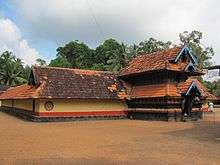
There are eighteen Hindu temples there and more than 30 more in the surrounding countryside. The two most famous are Subrahmania Swamy temple and Mannarasala Temple.[9]and Kolathu Devi temple
The Subrahmanya Swamy temple in Haripad is one of the oldest temples in Kerala. Dedicated to Subrahmanya Swamy, it is believed that the temple was established even before the advent of Kali Yuga. The temple was consecrated on the Pushya star of Makara Masa. This day is celebrated as the founding day of the temple every year. It is believed that Lord Vishnu appreaded as a saint to consecrate the temple. In 1096 of the Malayalam calendar, the temple caught fire, but the golden flag mast (erected 1067) and the Koothambalam were saved from the fire. The current temple was built during the period of King Chithira Thirunal Balarama Varma, who reigned from 1930-1949 (Gregorian Calendar).[10] This temple holds three festivals yearly.[11] The Chithira Ulsavam which starts on the day of Vishu and lasts ten days.
The Mannarasala Temple is a Nagaraja temple situated near Haripad. Like most snake temples, it is nestled in a forest glade, and has over 30,000 images of snakes along the paths and among the trees. It is the largest such temple in Kerala. Women seeking fertility come to worship there, and upon the birth of their child, they come again to hold thanksgiving ceremonies, often bringing new snake images as offerings.[9]Sri Ramakrishna Asram at Haripad is the first one in the State of Kerala established in 1913.
Another main feature of Haripad which attracts even the foreigners is the Payippad Jalolsavam, a three-day water festival conducted on the nearby Payippad Lake. It is believed the current idol of Lord Subrahmanya was brought from Kandalloor with escort of snake boats and vallasadya. Payippad Jalolsavam is conducted to renew this memory.[6]
Government
Haripad is the headquarters of Karthikappally taluk, which includes 18 small villages: Arattupuzha, Cheppad, Cheruthana, Chingoli, Haripad, Kandallor, Karthikappally, Karuvatta, Kayamkulam, Keerikkad, Krishnapuram, Kumarapuram, Muthukulam, Pallippad, Pathiyoor, Puthuppally, Thrikkunnapuzha, Veeyapuram.[3] Haripad has Taluk Hospital with many specialists.There is a proposal of the establishment of Haripad Medical College.The land acquisition survey for the medical college is done.
The Haripad assembly constituency is part of Alappuzha (Lok Sabha constituency).[12]
Famous people
- Rakesh Rajan (1988Born) - A Mechanical Engineer from Chingoli.
- Swami Nirmalananda (1863–1938) - A direct monastic disciple of Sri Ramakrishna (1836–1886)[13]
- Kerala Varma Valiya Koithampuran (1845 – 1914) author of Mayurasandesa, stayed in Haripad while writing the Sandesh Kavyam which consists of love letters to his dear wife to be sent through peacocks.[5]
- T. K. Madhavan (1885—1930) - Indian Social Reformer
- Padmarajan (1946–1991) – Famous Malayalam film director and writer
- M. G. Radhakrishnan (1940–2010) - Karnatic Musician, Music director
- K. Omanakutty - Musician
- M. G. Sreekumar (1957- ) - Musician,Singer, Music Director
- A. P. Udhayabhanu - Congress Leader, Writer, Speaker,PSC Chairman
- Sreekumaran Thampi – Writer, Director
- K. Madhu – Director
- Erickavu N. Sunil – National Award Winning Mridangam artist
- Mallika Sukumaran – Actress
- Ashokan - Actor
- Navya Nair – Cine artist
- C.B.C Warrier (1932-2013), Ex-MLA, CPM Leader, Trade Union °Leader"
- Harikrishnan Nair,serial producer
- Santhosh Sivan,cinematographer,director
References
- ↑ "Location Map of Haripad". Haripad.in.
- 1 2 "Haripad Overview". Blessings on the Net.
- 1 2 "About Haripad". Haripad.in.
- ↑ "Veethi".
- 1 2 3 4 5 "History of Haripad". Haripad.in.
- 1 2 "History of Haripad". Blessings on the Net.
- ↑ "About Haripad". holidayiq.com.
- ↑ "Climate in India". topindiatour.com.
- 1 2 "Haripad". Touristlink.com.
- ↑ "Legands". haripadsubrahmanyaswamytemple.com.
- ↑ "Festivals". haripadsubrahmanyaswamytemple.com.
- ↑ "Assembly Constituencies – Corresponding Districts and Parliamentary Constituencies" (PDF). Kerala. Election Commission of India. Retrieved 20 October 2008.
- ↑ "Swami Nirmalananda: His life and teachings" (PDF). vivekananda.net.
External links
| Wikimedia Commons has media related to Haripad. |
- About Karichalchundan
- snakeboat races – Snake boat races in Haripad