Vypin

Vypin or Vypeen (Malayalam: വൈപ്പിന്) is one of a group of islands that form part of the city of Kochi, in the southwestern Indian state of Kerala. Vypin is one of the densely populated islands in asia.The island is about 27 kilometres (17 mi) long and is connected to mainland Kochi by a series of bridges known as the Goshree bridges, which start at Kalamukku in Vypin, touch other two islands then finish at Marine Drive, Kochi.
The western coast of Vypin has the longest beaches in Kochi namely, the Cherai Beach, Kuzhuppilly Beach and the Puthuvype Beach. Munambam, at par the northern tip of Vypin, is home to the Munambam Fishing Harbour, the largest fishing harbour in Kochi. Puthuvype has become the major industrial hub in Kerala and the fastest growing city suburb due to the SPM project run by Kochi Refineries, the Puthuvyp LNG Terminal, the IOC Bottling Plant and the proposed Oseanarium.
There are ten lighthouses in Kerala, one of which is situated at Puthuvype Beach.
India’s first international container trans-shipment terminal (ICTT) in the Special Economic Zone at Vallarpadam Island, designed to handle the largest container ships, was opened by then Prime Minister Manmohan Singh on February 11, 2011.
There are regular boat services from Fort Kochi to Vypin Island. In 2004 a bridge was built by the Goshree Islands Development Authority (GIDA) to connect Vypin to the mainland. The Goshree bridges also connect the islands Mulavukad and Vallarpadam.
Vypin is now a fast-developing suburb of Kochi City. Today, all the basic infrastructure of modern living is available in Vypin. Njarakkal is the business capital of Vypin. Travellers from North Kerala can use the Vypin-Munambam state highway to reach Ernakulam.
History
The island was formed in the year 1341 following a heavy flood.
Location
 |
Arabian Sea | Arabian Sea and Azhikode | Vembanad Lake and North Paravur | |
| Arabian Sea | |
Vembanad Lake | ||
| ||||
| | ||||
| Arabian Sea | Arabian Sea, Fort Kochi, Mattancherry and Mundamveli | Vembanad Lake and Ernakulam |
Villages of Vypin
- Fort Vypin
- Kalamukku
- Puthuvyppu
- Ochanthuruth
- Valappu
- Malippuram
- Elamkunnapuzha
- Perumpilly
- Njarakkal
- Veliyathaamparambu
- Nayarambalam
- Nedungad
- Edavanakad
- Kuzhuppilly
- Cherai
- Pallippuram
- Munambam
Tourist attractions
- Nedungad is a nearby much smaller island.

- Karthedom
- Lighthouse at Puthuvype open from 3 p.m. to 5 p.m. on all days.

- manjanakad contains one of the oldest resorts in vypeen known as Country Club Resort where you can enjoy scenic backwaters which have a unique ecosystem - freshwater from the rivers meets the seawater from the Arabian Sea which is connected to the most famous Vembanad Kayal.

- Cherai Beach is located in Vypin island, Kochi, India. Cherai Beach is just 25 km from Kochi, and 30 km from Cochin International Airport. The nearest towns are North Paravur (6 km) and Kodungallur (10 km) and the nearest railway station is Aluva (20 km)

- Pallipuram Fort, 16th century fort (open on Thursdays).It was built by the Portuguese in 1503 and is the oldest existing European fort in India. The Dutch captured the fort in 1661 and sold it to the State of Travancore in 1789. This fort is situated in the northern extremity of the Vypeen island. This fort is in a hexagonal shape and popularly known as ayikkotta or Alikotta.

- Sahodaran Ayyappan Smarakam at Cherai
- Veeranpuzha, the Vypeen part of Vembanad Lake The Chinese nets are common in this big river.
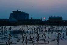
 Sunrise at Veeranpuzha.
 - cruz milagress church this is the one of the oldest parish in vypin. it is situated near to the river. this church was constructed in 1932.
- Kuzhuppilly Beach is a nearby Pallathamkulangara.
- Sree Perumpadappil Bhagavathi Temple,Mayabazar,Edavanakad. is a famous Pilgrimage Center in Vypeen.
- NJARAKKAL FISH FARM,Narakkal (Njarakkal) Fish Farm is situated in Vypeen (Vypin) island of Ernakulam district with an area of 18.4 Ha. Production depends on the introduction of quality seed from other sources. An Integrated Disease Management System (IDMS) has been implemented on experimental basis in collaboration with CUSAT. An Aqua Tourism is also visited by a lot of tourists. The aqua tourism project, providing tourists with the opportunity to experience fishing. Boating through the canals and tasty fish dishes are served as additional attractions. Njarakkal is Heart of Vypin & is the Pearl of Cochin.
- Elamkunapuzha Temple
See also
External links
| Wikimedia Commons has media related to Vypin Island. |
Coordinates: 9°58′26″N 76°14′38″E / 9.974°N 76.244°E