Nedumangad


| Nedumangad നെടുമങ്ങാട് NDD | |
|---|---|
| Town | |
|
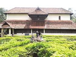
Koyikkal Palace | |
 Nedumangad  Nedumangad | |
| Coordinates: 8°36′12″N 77°00′10″E / 8.60333°N 77.00278°ECoordinates: 8°36′12″N 77°00′10″E / 8.60333°N 77.00278°E | |
| Country | India |
| State | Kerala |
| District | Thiruvananthapuram |
| Government | |
| • Body | municipality |
| Area | |
| • Total | 32.52 km2 (12.56 sq mi) |
| Elevation | 68 m (223 ft) |
| Population (2011)[1] | |
| • Total | 60,161 |
| • Density | 1,800/km2 (4,800/sq mi) |
| Time zone | IST (UTC+5:30) |
| Vehicle registration | KL-21 |
| Website | http://www.nedumangadmunicipality.in/ |
Nedumangad is a municipality in Thiruvananthapuram district in the Indian state of Kerala. It is a suburb of the extended metropolitan region of Thiruvananthapuram city. It is located around 17 km to the north-east of Thiruvananthapuram city on the Thiruvananthapuram — Thenmala State Highway. It is an important centre for the commercial trade in pepper and rubber. A wholesale market set up by the Department of Agriculture (with the assistance of the European Union) is also situated there. It's also the headquarters of Nedumangad taluk.
History
Nedumangad panchayat was formed on 1936. It was one among the 4 Panchayats sanctioned by Sir C.P.Ramaswamy Iyer (Diwan-Thiruvithamcore). The others were Paravur, Boothapandi and Perumbavoor.[2]
Geography
Nedumangad is located at 8°36′N 77°00′E / 8.6°N 77.0°E.[3] It has an average elevation of 68 metres (223 feet).
It lies 18 km from Thiruvananthapuram (or Trivandrum) on the way to Ponmudi hill resort. It is the capital of the taluk, and is unique for having no coastal belt or railway lines.
It is bounded on the west by Trivandrum Taluk, on the east by the State of Tamil Nadu, on the south by Neyyattinkara Taluk and on the north by Kollam District.
Places of interest
Agasthyarkoodam, a mountain preserve famous for its abundant ayurvedic herbs and medicinal plants is around 50 km away. About 32 km from Nedumangad, en route to the Ponmudi Hill Resort lies the Peppara Wildlife Sanctuary, which is of particular interest to ornithologists. Near Nedumangad town another Monolithic - Thiruchittapara is located. With Siva Vishnu Temple, lots of monkeys congregated this place. The name Nedumangadu means kadu (forest) of Vishnu, who was called Neduman, Neduvan, and Nediyavan in ancient texts like Chilappadikaram. Vembayam is another famous town in Nedumangadu taluk. Kerala's Numismatic museum is at Koikkal Palace within Nedumangad Town. The palace was the residence of one of the prominent matriarchal lines of Travancore.
Other place nearby
- Pathiyanadu Sree Bhadrakali Temple, Mullassery, Karakulam (7.6 km)
- Kallar - 25.2 km
- Kinattumuck muslim jamath velavoor
- Shiva Temple Nedumangadu
- Aayukshetram - 2.5 km
- Nedumangad Muslim Jamaath
- Pazhavadi Ganapathy Temple
- Melamcode Devi Temple, Melamcode (1 km)
- Ponmudi (45 km)
- Meenmutty Falls (30 km)
- Happyland, Vembayam (Water Theme Park) (15 km)
- Thirichittoor Rock at Venkavila - (3 km)
- Koyikkal Palace and Museum - (400 metres)
- aruvikkara dam-7 km
- Indian space research organisation- (6 km)
- Indian Institute of Space Science and Technology-(7 km)
- Govt .Hospital
- Poovathoor Mangodu shri Mahavishnu Temple (8 km)
- Thampuran Para, Vembayam
- Neyyar dam and Neyyar Wild life sanctuary
- Govt.Polytechnic college.
- Ammavan Rock Venkode
- Thenpara Poovathoor.
- KELTRON Karakulam
- MUHAVOOR MAHAVISHNU TEMPLE
Transport
Road transport
- It is located 17 km to the north-east of thiruvananthapuram city.On the way to thiruvananthapuram-thenkasi state highway. Bus service connected by kerala state road transport corporation (ksrtc).There are also bus connected by Nedumangad to Trivandrum, Eastfort, Attingal, Palode, Vithura, Kattakada, Ponmudi, Kanyakumari, Thenkasi and major cities and towns in Kerala.Volvo bus which connects Nedumangadu to Trivandrum- Kovalam frequently
Rail
- nearest railway station is Thiruvananthapuram Central railway station
Air
- Nearest airport is Thiruvananthapuram International Airport.
State Government Offices
- Nedumangad Taluk Office
- Nedumangad, Sub Registrar's Office
- Nedumangad meteorological department
- Nedumangad (village office)revenue tower
- Nedumangad Municipality
- Nedumangad police station
- Nedumangad sub regional transport office
- Nedumangad PWD
- Taluk Civil Supplies Office
Politics
Nedumangad assembly constituency is part of the Attingal (Lok Sabha constituency). C Divakkaran of CPI is MLA of Nedumangad assembly constituency and Dr.A.Sampath of CPIM is MP of Attingal Lok Sabha constituency. [5]
Theaters
- Surya theaters(A/C)
- Rani
- Surya paradise(A/C)
- Sree swaraswathi (A/C)
List of hospitals & Other Clinical Establishments
- District Hospital
- RIMS
- Venad
- SUT Medical College
- Dr.Gopinath's Diagnostic Services.
See also
References
- ↑ "Census of India Search details". censusindia.gov.in. Retrieved 10 May 2015.
- ↑ Historic Paravur
- ↑ Falling Rain Genomics, Inc - Nedumangad
- ↑ https://www.keralatourism.org/destination/koyikkal-palaceenedumangad/238
- ↑ "Assembly Constituencies - Corresponding Districts and Parliamentary Constituencies" (PDF). Kerala. Election Commission of India. Retrieved 2008-10-21.
Nedumangad itself is a Kerala Legislative assembly constituency and is currently won by Ruling party(UDF)Mr.Palode Ravi.
External links
| Wikimedia Commons has media related to Nedumangad. |
- Koyikkal Palace
- GOVERNMENT POLYTECHNIC COLLEGE NEDUMANGAD
- Media For Social Change Studio and Ashram
- Happyland (Water Theme Park)
- Crescet Residential High School,Azhicode
- Darsana English Medium Higher Secondary School
- Lourdes Mount English Medium Higher Secondary School
- Mohandas College Of Engineering Technology
- P. A. Aziz College of Engineering
- Muslim Association College of Engineering
- Gokulam Medical College
- SUT College of Medicine
- 100 Years of Ayurveda Knowledge
- World's Largest Cultural Archive
- National Training College
- Govt High School Karippoor
- Manarul Huda Higher Secondary school
District HQ: Thiruvananthapuram | |||||||||||
| History |  | ||||||||||
| Geography | |||||||||||
| Cities and Taluks |
| ||||||||||
| Transport | |||||||||||
| Education |
| ||||||||||
| Buildings | |||||||||||
| Culture | |||||||||||
| Lok Sabha constituencies | |||||||||||
| Sports | |||||||||||
| Museums | |||||||||||