Arabian Peninsula
.png) | |
| Area | 3.2 million km2 (1.25 million mi²) |
|---|---|
| Population | ~78 million |
| Demonym | Arabian |
| Countries |
|

The Arabian Peninsula, simplified Arabia[1] (Arabic: الجزيرة العربية al-jazīra al-ʿarabiyya, « Arabian island ») is a peninsula of Western Asia situated northeast of Africa on the Arabian plate. From a geological perspective, it is considered a subcontinent of Asia.
It is the largest peninsula in the world, at 3,237,500 km2 (1,250,000 sq mi). The Arabian Peninsula consists of the countries Yemen, Oman, Qatar, Bahrain, Kuwait, Saudi Arabia and the United Arab Emirates as well as parts of southern Iraq and Jordan.[2] The peninsula formed as a result of the rifting of the Red Sea between 56 and 23 million years ago, and is bordered by the Red Sea to the west, the Persian Gulf to the northeast, the Levant to the north and the Indian Ocean to the southeast. The Arabian Peninsula plays a critical geopolitical role in the Middle East and the Arab world due to its vast reserves of oil and natural gas.
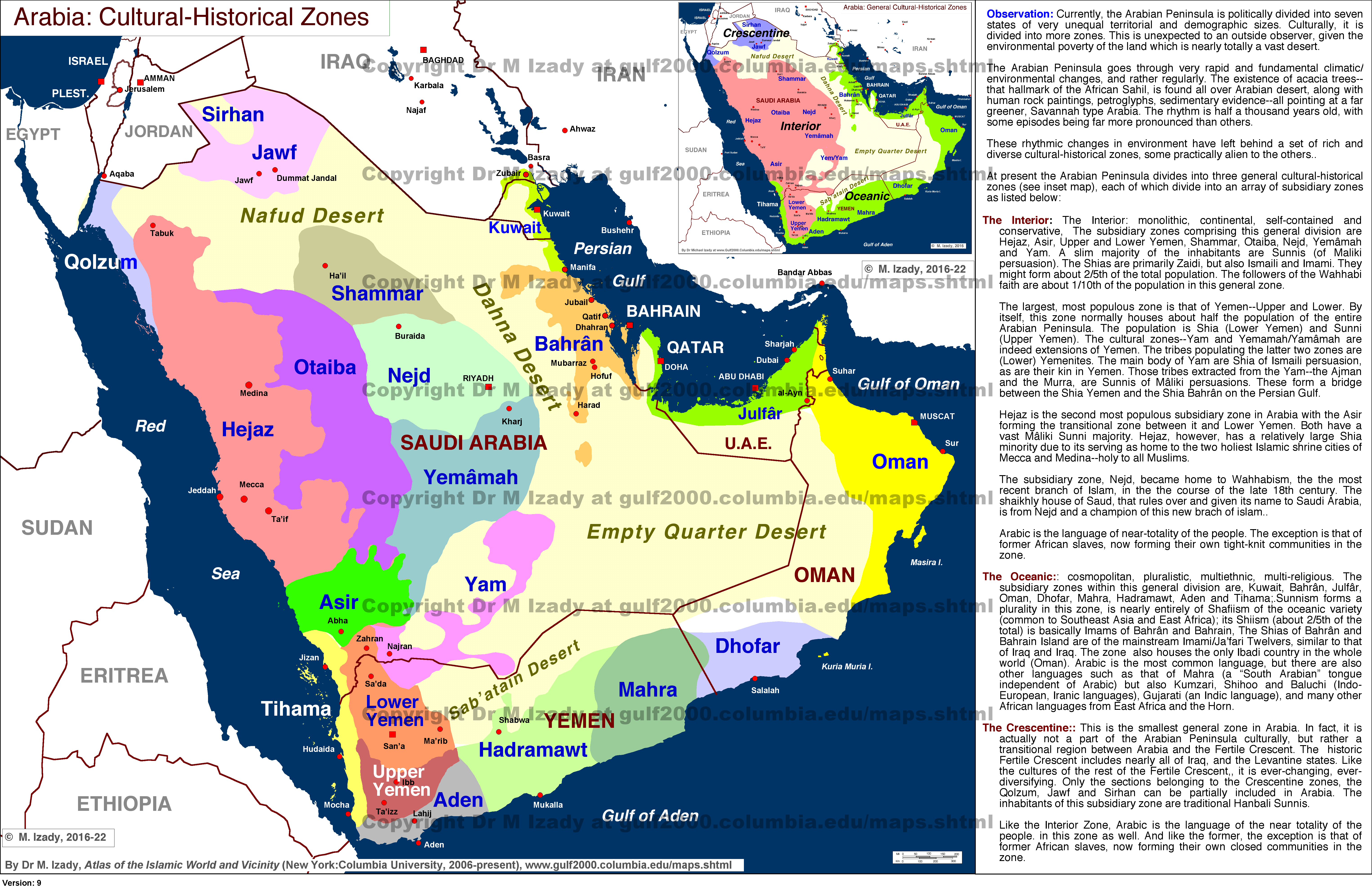
Before the modern era, it was divided into four distinct regions: Hejaz, Najd, Southern Arabia and Eastern Arabia. Hejaz and Najd make up most of Saudi Arabia. Southern Arabia consists of Yemen and some parts of Saudi Arabia and Oman (Dhofar). Eastern Arabia consists of the entire coastal strip of the Persian Gulf.
Geography
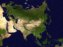
The Arabian Peninsula is located in the continent of Asia and bounded by (clockwise) the Persian Gulf on the northeast, the Strait of Hormuz and the Gulf of Oman on the east, the Arabian Sea on the southeast and south, the Gulf of Aden on the south, the Bab-el-Mandeb strait on the southwest, and the Red Sea which is located on the southwest and west.[3] The northern portion of the peninsula merges with the Syrian Desert with no clear border line, although the northern boundary of the Arabian Peninsula is generally considered to be the northern borders of Saudi Arabia and Kuwait.[3]
The most prominent feature of the peninsula is desert, but in the southwest there are mountain ranges which receive greater rainfall than the rest of the Arabian Peninsula. Harrat ash Shaam is a large volcanic field that extends from the northwestern Arabian Peninsula into Jordan and southern Syria.[4]
Political boundaries

The peninsula's constituent countries are (clockwise north to south) Kuwait, Bahrain, Qatar, and the United Arab Emirates (UAE) on the east, Oman on the southeast, Yemen on the south and Saudi Arabia at the center.[3] The island nation of Bahrain lies off the east coast of the peninsula.
Six countries, including Saudi Arabia, Kuwait, Bahrain, Qatar, United Arab Emirates and Oman form the Gulf Cooperation Council (GCC). This is however a disputed term. Iranians assert that it is a historical and internationally recognized convention to name it the Persian Gulf, while Arab States, and most notably the six GCC member countries, have been claiming that the Gulf is Arabian since its shallow marine depths are a geological continuity of the Arabian peninsula's Eastern low-lying coasts, from Kuwait to the UAE's Northern Emirates.[5]
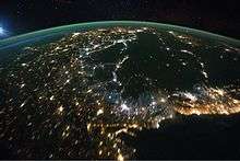
The Kingdom of Saudi Arabia covers the greater part of the peninsula. The majority of the population of the peninsula live in Saudi Arabia and in Yemen. The peninsula contains the world's largest reserves of oil. Saudi Arabia and the UAE are economically the wealthiest in the region. Qatar, a small peninsula in the Persian Gulf on the larger peninsula, is home of the Arabic-language television station Al Jazeera and its English-language subsidiary Al Jazeera English. Kuwait, on the border with Iraq, is an important country strategically, forming one of the main staging grounds for coalition forces mounting the invasion of Iraq in 2003.
Population
| Historical population | ||
|---|---|---|
| Year | Pop. | ±% |
| 1950 | 9,481,713 | — |
| 1960 | 11,788,232 | +24.3% |
| 1970 | 15,319,678 | +30.0% |
| 1980 | 23,286,256 | +52.0% |
| 1990 | 35,167,709 | +51.0% |
| 2000 | 47,466,523 | +35.0% |
| 2010 | 63,364,000 | +33.5% |
| 2014 | 77,584,000 | +22.4% |
| Political Definition: Gulf Cooperation Council and Yemen Sources:1950-2000[6] 2000-2014[7] | ||
| Historical population | ||
|---|---|---|
| Year | Pop. | ±% |
| 1950 | 356,235 | — |
| 1970 | 1,329,168 | +273.1% |
| 1990 | 4,896,491 | +268.4% |
| 2010 | 11,457,000 | +134.0% |
| 2014 | 17,086,000 | +49.1% |
| 4 smallest states (area) of Gulf Cooperation Council with entire coastline in Persian Gulf: UAE, Bahrain, Qatar, Kuwait Sources:1950-2000[8] 2000-2014[7] | ||
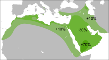
Though historically lightly populated political Arabia is noted for a high population growth rate - as the result of both very strong inflows of migrant labor as well as sustained high birth rates. The population tends to be relatively young and heavily skewed gender ratio dominated by males. In many states, the number of South Asians exceeds that of the local citizenry. The 4 smaller states (by area) having their entire coastlines on the Persian Gulf exhibit the world's most extreme population growth, roughly tripling every 20 years.
In 2014, the estimated population of the Arabian Peninsula is 77,983,936 (including expatriates).[9]
Y-Chromosome
Listed here are the human Y-chromosome DNA haplogroups in Arabia (Yemen, Oman, Qatar, Kuwait, Saudi Arabia and the United Arab Emirates).[10][11]
Haplogroup J is the most abundant component in the Arabian peninsula embracing more than 50% of its Y-chromosomes. Its two main subclades (J1-M267 and J2-M172), show opposite latitudinal gradients in the Middle East. J1-M267 is more abundant in the southern areas, reaching a frequency around 73% in Yemen, whereas J2-M172 is more common in the Levant.
J (L222.2) Accounts for the majority of (L147.1) in Saudi Arabia. Seems to be an exclusively Adnani marker.[12]
| Haplogroup | % |
| n | 618 |
| A | 0.16 |
| B | 0.81 |
| C | 0.97 |
| DE | 0.81 |
| E-M33 | 0.32 |
| E-M2 | 5.66 |
| E-M35 | 1.94 |
| E-M78 | 0.49 |
| E-V12 | - |
| E-V32 | - |
| E-V13 | 0.32 |
| E-V22 | 2.43 |
| E-V65 | - |
| E-M81 | 0.16 |
| E-M34 | 5.66 |
| F-M89 | 1.29 |
| G-M201 | 2.91 |
| H-M69 | 2.1 |
| I | - |
| J1-M267 | 44.01 |
| J2-M172 | 11.32 |
| K | 4.37 |
| L | 2.27 |
| N | - |
| O | 0.65 |
| P,R | 0.32 |
| Q | 1.46 |
| R1a1 | 6.31 |
| R1b-M343 | 0.16 |
| R1b-V88 | - |
| R1b-M269 | 2.43 |
| R2 | 0.16 |
| T-M70 | 0.49 |
Landscape


Geologically, this region is perhaps more appropriately called the Arabian subcontinent because it lies on a tectonic plate of its own, the Arabian Plate, which has been moving incrementally away from the rest of Africa (forming the Red Sea) and north, toward Asia, into the Eurasian plate (forming the Zagros mountains). The rocks exposed vary systematically across Arabia, with the oldest rocks exposed in the Arabian-Nubian Shield near the Red Sea, overlain by earlier sediments that become younger towards the Persian Gulf. Perhaps the best-preserved ophiolite on Earth, the Semail Ophiolite, lies exposed in the mountains of the UAE and northern Oman.
The peninsula consists of:
- A central plateau, the Najd, with fertile valleys and pastures used for the grazing of sheep and other livestock
- A range of deserts: the Nefud in the north,[13] which is stony; the Rub' al Khali or Great Arabian Desert in the south, with sand estimated to extend 600 ft (180 m) below the surface; between them, the Dahna
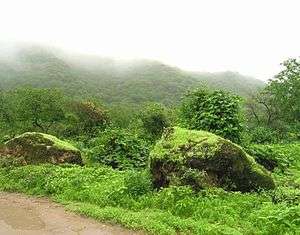
- In Hejaz, ranges of mountains, paralleling the Red Sea coast on the west (e.g. Asir province) but also at the southeastern end of the peninsula (Oman). The mountains show a steady increase in altitude westward as they get nearer to Yemen, and the highest peaks and ranges are all located in Yemen The highest, Jabal an Nabi Shu'ayb in Yemen, is 3666 m high
- Stretches of dry or marshy coastland with coral reefs on the Red Sea side (Tihamah)
- Oases and marshy coast-land in Eastern Arabia on the Persian Gulf side
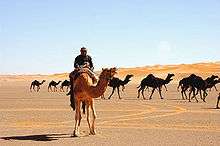
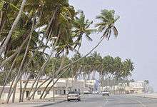
Arabia has few lakes or permanent rivers. Most areas are drained by ephemeral watercourses called wadis, which are dry except during the rainy season. Plentiful ancient aquifers exist beneath much of the peninsula, however, and where this water surfaces, oases form (e.g. Al-Hasa and Qatif, two of the world's largest oases) and permit agriculture, especially palm trees, which allowed the peninsula to produce more dates than any other region in the world. In general, the climate is extremely hot and arid, although there are exceptions. Higher elevations are made temperate by their altitude, and the Arabian Sea coastline can receive surprisingly cool, humid breezes in summer due to cold upwelling offshore. The peninsula has no thick forests, although desert-adapted wildlife is present throughout the region.
According to NASA's Gravity Recovery and Climate Experiment (GRACE) satellite data (2003 - 2013) analysed in a University of California, Irvine (UCI)-led study published in Water Resources Research on 16 June 2015, the most over-stressed aquifer system in the world is the Arabian Aquifer System, upon which more than 60 million people depend for water.[14] Twenty-one of the thirty seven largest aquifers "have exceeded sustainability tipping points and are being depleted" and thirteen of them are "considered significantly distressed."[14]
A plateau more than 2,500 feet (760 m) high extends across much of the Arabian Peninsula. The plateau slopes eastwards from the massive, rifted escarpment along the coast of the Red Sea, to the shallow waters of the Persian Gulf. The interior is characterised by cuestas and valleys, drained by a system of wadis. A crescent of sand and gravel deserts lies to the east.
Land and sea


Most of the Arabian Peninsula is unsuited to agriculture, making irrigation and land reclamation projects essential. The narrow coastal plain and isolated oases, amounting to less than 1% of the land area, are used to cultivate grains, coffee and tropical fruits. Goat, sheep, and camel husbandry is widespread elsewhere throughout the rest of the Peninsula. Some areas have a summer humid tropical monsoon climate, in particular the Dhofar and Al Mahrah areas of Oman and Yemen. These areas allow for large scale coconut plantations. Much of Yemen has a tropical monsoon rain influenced mountain climate. The plains usually have either a tropical or subtropical arid desert climate or arid steppe climate. The sea surrounding the Arabian Peninsula is generally tropical sea with a very rich tropical sea life and some of the world's largest, undestroyed and most pristine coral reefs. In addition, the organisms living in symbiosis with the Red Sea coral, the protozoa and zooxanthellae, have a unique hot weather adaptation to sudden rise (and fall) in sea water temperature. Hence these coral reefs are not affected by coral bleaching caused by rise in temperature as elsewhere in the indopacific coral sea. The reefs are also unaffected by mass tourism and diving or other large scale human interference. However, some reefs were destroyed in the Persian Gulf, mostly caused by phosphate water pollution and resultant increase in algae growth as well as oil pollution from ships and pipeline leakage.

The fertile soils of Yemen have encouraged settlement of almost all of the land from sea level up to the mountains at 10,000 feet (3,000 m). In the higher reaches elaborate terraces have been constructed to facilitate grain, fruit, coffee, ginger and khat cultivation. Arabian peninsula is known for its rich oil, i.e. petroleum production due to its geographical location.
Etymology
During the Hellenistic period, the area was known as Arabia or Aravia (Greek: Αραβία). The Romans named three regions with the prefix "Arabia", encompassing a larger area than the current term "Arabian Peninsula":
- Arabia Petraea: for the area that is today southern modern Syria, Jordan, the Sinai Peninsula and northwestern Saudi Arabia. It was the only one that became a province, with Petra as its capital.
- Arabia Deserta ("Desert Arabia"): signified the desert interior of the Arabian peninsula. As a name for the region, it remained popular into the 19th and 20th centuries, and was used in Charles M. Doughty's Travels in Arabia Deserta (1888).
- Arabia Felix ("Fortunate Arabia"): was used by geographers to describe what is now Yemen, which enjoys more rainfall, is much greener than the rest of the peninsula and has long enjoyed much more productive fields.
The Arab inhabitants used a north-south division of Arabia: Al Sham-Al Yaman, or Arabia Deserta-Arabia Felix. Arabia Felix had originally been used for the whole peninsula, and at other times only for the southern region. Because its use became limited to the south, the whole peninsula was simply called Arabia. Arabia Deserta was the entire desert region extending north from Arabia Felix to Palmyra and the Euphrates, including all the area between Pelusium on the Nile and Babylon. This area was also called Arabia and not sharply distinguished from the peninsula.[15]
The Arabs and the Ottoman Empire considered the west of the Arabian Peninsula region where the Arabs lived 'the land of the Arabs' – Bilad al-Arab (Arabia), and its major divisions were the bilad al-Sham (Syria), bilad al-Yaman (the Land of the southern Peninsula), and Bilad al-Iraq and modern-day Kuwait (the Land of the River Banks).[16] The Ottomans used the term Arabistan in a broad sense for the subcontinent itself starting from Cilicia, where the Euphrates river makes its descent into Syria, through Palestine, and on through the remainder of the Sinai and Arabian peninsulas.[17]
The provinces of Arabia were: Al Tih, the Sinai peninsula, Hedjaz, Asir, Yemen, Hadramaut, Mahra and Shilu, Oman, Hasa, Bahrain, Dahna, Nufud, the Hammad, which included the deserts of Syria, Mesopotamia and Babylonia.[18][19]
History
The history of the Arabian Peninsula goes back to the beginnings of human habitation in Arabia up to 130,000 years ago. The region has twice in world history had a global impact. The first was in the 7th century when it became the cradle of Islam. The second was from the mid-20th century when the discovery of vast oil deposits propelled it into a key economic and geo-political role. At other times, the region existed in relative obscurity and isolation, although from the 7th century the cities of Mecca and Medina had the highest spiritual significance for the Islamic world, Mecca being the destination for the Hajj annual pilgrimage.
Pre-Islamic Arabia


There is evidence that human habitation in the Arabian Peninsula dates back to about 106,000 to 130,000 years ago.[20] However, the harsh climate historically prevented much settlement. In pre-Islamic Saudi Arabia, apart from a small number of urban trading settlements, such as Mecca and Medina, located in the Hejaz in the west of the peninsula.[21]
However, archaeology has revealed the existence of civilizations in pre-Islamic Arabia (such as Thamud). There were many civilizations in the Arabian Peninsula before Islam, especially in South Arabia.[22][23] South Arabian civilizations include Sheba, Himyarite Kingdom, Kingdom of Awsan, Kingdom of Ma'īn and Sabaean Kingdom. Central Arabia was the sole location of kingdom of Kinda in the 4th, 5th and early 6th centuries AD. Eastern Arabia was home to the Dilmun civilization. The earliest known events in Arabian history are migrations from the Peninsula into neighbouring areas.[24]
The Arabian peninsula has long been accepted as the original Urheimat of the Semitic languages by a majority of scholars.[25][26][27][28]
"Shamir of Dhu-Raydan and Himyar had called in the help of the clans of Habashat for against the kings of Saba; but Ilmuqah granted... the submission of Shamir of Dhu-Raydan and the clans of Habashat."[29]
The Rise of Islam

The seventh century saw the introduction of Islam in the Arabian Peninsula. The Islamic prophet Muhammad, was born in Mecca in about 570 and first began preaching in the city in 610, but migrated to Medina in 622. From there he and his companions united the tribes of Arabia under the banner of Islam and created a single Arab Muslim religious polity in the Arabian peninsula.

He established a new unified polity in the Arabian peninsula which under the subsequent Rashidun and Umayyad Caliphates saw a century of rapid expansion of Arab power well beyond the Arabian peninsula in the form of a vast Muslim Arab Empire with an area of influence that stretched from the northwest Indian subcontinent, across Central Asia, the Middle East, North Africa, southern Italy, and the Iberian Peninsula, to the Pyrenees.
Muhammad began preaching Islam at Mecca before migrating to Medina, from where he united the tribes of Arabia into a singular Arab Muslim religious polity. With Muhammad's death in 632 AD, disagreement broke out over who would succeed him as leader of the Muslim community. Umar ibn al-Khattab, a prominent companion of Muhammad, nominated Abu Bakr, who was Muhammad's intimate friend and collaborator. Others added their support and Abu Bakr was made the first caliph. This choice was disputed by some of Muhammad's companions, who held that Ali ibn Abi Talib, his cousin and son-in-law, had been designated his successor. Abu Bakr's immediate task was to avenge a recent defeat by Byzantine (or Eastern Roman Empire) forces, although he first had to put down a rebellion by Arab tribes in an episode known as the Ridda wars, or "Wars of Apostasy".[30]
Following Muhammad's death in 632, Abu Bakr became leader of the Muslims as the first Caliph. After putting down a rebellion by the Arab tribes (known as the Ridda wars, or "Wars of Apostasy"), Abu Bakr attacked the Byzantine Empire. On his death in 634, he was succeeded by Umar as caliph, followed by Uthman ibn al-Affan and Ali ibn Abi Talib. The period of these first four caliphs is known as al-khulafā' ar-rāshidūn: the Rashidun or "rightly guided" Caliphate. Under the Rashidun Caliphs, and, from 661, their Umayyad successors, the Arabs rapidly expanded the territory under Muslim control outside of Arabia. In a matter of decades Muslim armies decisively defeated the Byzantine army and destroyed the Persian Empire, conquering huge swathes of territory from the Iberian peninsula to India. The political focus of the Muslim world then shifted to the newly conquered territories.[31][32]
Nevertheless, Mecca and Medina remained the spiritually most important places in the Muslim world. The Qur'an requires every able-bodied Muslim who can afford it, as one of the five pillars of Islam, to make a pilgrimage, or Hajj, to Mecca during the Islamic month of Dhu al-Hijjah at least once in his or her lifetime.[33] The Masjid al-Haram (the Grand Mosque) in Mecca is the location of the Kaaba, Islam's holiest site, and the Masjid al-Nabawi (the Prophet's Mosque) in Medina is the location of Muhammad tomb; as a result, from the 7th century, Mecca and Medina became the pilgrimage destinations for large numbers of Muslims from across the Islamic world.[34]
The Middle Ages
Despite its spiritual importance, in political terms Arabia soon became a peripheral region of the Islamic world, in which the most important medieval Islamic states were based at various times in such far away cities as Damascus, Baghdad, and Cairo.

However, from the 10th century (and, in fact, until the 20th century) the Hashemite Sharifs of Mecca maintained a state in the most developed part of the region, the Hejaz. Their domain originally comprised only the holy cities of Mecca and Medina but in the 13th century it was extended to include the rest of the Hejaz. Although, the Sharifs exercised at most times independent authority in the Hejaz, they were usually subject to the suzerainty of one of the major Islamic empires of the time. In the Middle Ages, these included the Abbasids of Baghdad, and the Fatimids, Ayyubids and Mamluks of Egypt.[35]
Modern history

The provincial Ottoman Army for Arabia (Arabistan Ordusu) was headquartered in Syria, which included Lebanon, Palestine, and the Transjordan region. It was put in charge of Syria, Cilicia, Iraq, and the remainder of the Arabian Peninsula.[36][37] The Ottomans never had any control over central Arabia, also known as the Najd region.
The Damascus Protocol of 1914 provides an illustration of the regional relationships. Arabs living in one of the existing districts of the Arabian peninsula, the Emirate of Hejaz, asked for a British guarantee of independence. Their proposal included all Arab lands south of a line roughly corresponding to the northern frontiers of present-day Syria and Iraq. They envisioned a new Arab state, or confederation of states, adjoining the southern Arabian Peninsula. It would have comprised Cilicia – İskenderun and Mersin, Iraq with Kuwait, Syria, Lebanon, Jordan, and Palestine.[38]
In the modern era, the term bilad al-Yaman came to refer specifically to the southwestern parts of the peninsula. Arab geographers started to refer to the whole peninsula as 'jazirat al-Arab', or the peninsula of the Arabs.[39]
Late Ottoman rule and the Hejaz Railway
In the beginning of the 20th century, the Ottomans embarked on an ambitious project: the construction of a railway connecting Istanbul, the capital of the Ottoman Empire and the seat of the Islamic Caliphate, and Hejaz with its holiest shrines of Islam which are the yearly pilgrimage destination of the Hajj. Another important goal was to improve the economic and political integration of the distant Arabian provinces into the Ottoman state, and to facilitate the transportation of military troops in case of need.
The Hejaz Railway was a narrow gauge railway (1050 mm) that ran from Damascus to Medina, through the Hejaz region of Arabia. It was originally planned to reach the holy city of Mecca, but due to the interruption of the construction works caused by the outbreak of World War I, it eventually became able to reach only Medina. It was a part of the Ottoman railway network and was built in order to extend the previously existing line between Istanbul and Damascus (which began from the Haydarpaşa Terminal).
The railway was started in 1900 at the behest of the Ottoman Sultan Abdul Hamid II and was built largely by the Turks, with German advice and support. A public subscription was opened throughout the Islamic world to fund the construction. The railway was to be a waqf, an inalienable religious endowment or charitable trust.[40]
The Arab Revolt and the unification of Saudi Arabia
The major developments of the early 20th century were the Arab Revolt during World War I and the subsequent collapse and partitioning of the Ottoman Empire. The Arab Revolt (1916–1918) was initiated by the Sherif Hussein ibn Ali with the aim of securing independence from the ruling Ottoman Empire and creating a single unified Arab state spanning from Aleppo in Syria to Aden in Yemen. During World War I, the Sharif Hussein entered into an alliance with the United Kingdom and France against the Ottomans in June 1916.
These events were followed by the unification of Saudi Arabia under King Abdulaziz Ibn Saud. In 1902 Ibn Saud had captured Riyadh. Continuing his conquests, Abdulaziz subdued Al-Hasa, Jabal Shammar, Hejaz between 1913 and 1926 founded the modern state of Saudi Arabia. The Saudis absorbed the Emirate of Asir, with their expansion only ending in 1934 after a war with Yemen. Two Saudi states were formed and controlled much of Arabia before Ibn Saud was even born. Ibn Saud however, established the third Saudi state.
Oil reserves
The second major development has been the discovery of vast reserves of oil in the 1930s. Its production brought great wealth to all countries of the region, with the exception of Yemen.
Civil war in Yemen
The North Yemen Civil War was fought in North Yemen between royalists of the Mutawakkilite Kingdom of Yemen and factions of the Yemen Arab Republic from 1962 to 1970. The war began with a coup d'état carried out by the republican leader, Abdullah as-Sallal, which dethroned the newly crowned Muhammad al-Badr and declared Yemen a republic under his presidency. The Imam escaped to the Saudi Arabian border and rallied popular support.
The royalist side received support from Saudi Arabia, while the republicans were supported by Egypt and the Soviet Union. Both foreign irregular and conventional forces were also involved. The Egyptian President, Gamal Abdel Nasser, supported the republicans with as many as 70,000 troops. Despite several military moves and peace conferences, the war sank into a stalemate. Egypt's commitment to the war is considered to have been detrimental to its performance in the Six-Day War of June 1967, after which Nasser found it increasingly difficult to maintain his army's involvement and began to pull his forces out of Yemen.
By 1970, King Faisal of Saudi Arabia recognized the republic and a truce was signed. Egyptian military historians refer to the war in Yemen as their Vietnam.[41]
Gulf War
In 1990 Iraq invaded Kuwait.[42] The invasion of Kuwait by Iraqi forces led to the 1990–91 Gulf War. Egypt, Qatar, Syria and Saudi Arabia joined a multinational coalition that opposed Iraq. Displays of support for Iraq by Jordan and Palestine resulted in strained relations between many of the Arab states. After the war, a so-called "Damascus Declaration" formalized an alliance for future joint Arab defensive actions between Egypt, Syria, and the GCC member states.[43]
Transport and industry
The extraction and refining of oil and gas are the major industrial activities in the Arabian Peninsula. The region also has an active construction sector, with many cities reflecting the wealth generated by the oil industry. The service sector is dominated by financial and technical institutions, which, like the construction sector, mainly serve the oil industry. Traditional handicrafts such as carpet-weaving are found in rural areas of Arabia.
See also
- Ancient history of Yemen
- Arab League
- Araby
- European exploration of Arabia
- Iram of the Pillars
- Kingdom of Aksum
- List of Arabian cities by population
- Mashriq
References
- ↑ Merriam Webster's Geographical Dictionary. Merriam-Webster (Third ed.). 2001. p. 61. ISBN 0877795460.
- ↑ Geopolitics of the World System - Page 337, Saul Bernard Cohen - 2003
- 1 2 3 "Arabia". Britannica Online Encyclopedia. Retrieved 2011-05-21.
- ↑ Weinstein, Y. (1 January 2007). "A transition from strombolian to phreatomagmatic activity induced by a lava flow damming water in a valley". Journal of Volcanology and Geothermal Research. 159 (1–3): Pages 267–284. doi:10.1016/j.jvolgeores.2006.06.015.
- ↑ A.S. Alsharhan, Z. A. Rizk, A. E. M. Nairn [et al.], 2001, Hydrogeology of an Arid Region, Elsevier.
- ↑ "International Programs". census.gov.
- 1 2 "Asia: Population Statistics in Maps and Charts for Cities, Agglomerations and Administrative Divisions of all Countries in Asia". citypopulation.de.
- ↑ "International Programs". census.gov.
- ↑ "The World Fact book". Central Intelligence Agency. 2007-08-07. Archived from the original on 12 August 2008. Retrieved 2008-08-12.
- ↑ Bekada A, Fregel R, Cabrera VM, Larruga JM, Pestano J, et al. (2013) Introducing the Algerian Mitochondrial DNA and Y-Chromosome Profiles into the North African Landscape. PLoS ONE 8(2): e56775. doi:10.1371/journal.pone.0056775
- ↑ Table S6. Y-chromosome haplogroup frequencies (%) in the studied populations. doi:10.1371/journal.pone.0056775.s006 (XLS)
- ↑ "The Genetic Atlas". www.thegeneticatlas.com. Retrieved 2015-10-11.
- ↑ Prothero, G.W. (1920). Arabia. London: H.M. Stationery Office. p. 15.
- 1 2 "Study: Third of Big Groundwater Basins in Distress", NASA, 16 June 2015, retrieved 26 June 2015
- ↑ See Pilgrimage and Holy Space in Late Antique Egypt, David Frankfurter, BRILL, 1998, ISBN 90-04-11127-1, page 163
- ↑ "A House of Many Mansions: The History of Lebanon Reconsidered, By Kamal Suleiman Salibi, Published by University of California Press, 1988, ISBN 0-520-07196-4". google.com. pp. 60–61.
- ↑ See for example Palestine: The Reality, Joseph Mary Nagle Jeffries, Published by Longmans, Green and co., 1939, Page 4
- ↑ see Review of Reviews and World's Work: An International Magazine, Albert Shaw ed., The Review of Reviews Corporation, 1919, page 408]
- ↑ "New International Encyclopedia - 2nd Edition, Dodd, Mead, Co., 1914". google.com. p. 795.
- ↑ Saudi Embassy (US) Website retrieved 20 January 2011
- ↑ Gordon, Matthew (2005). The Rise of Islam. p. 4. ISBN 0-313-32522-7.
- ↑ Robert D. Burrowes (2010). Historical Dictionary of Yemen. Rowman & Littlefield. p. 319. ISBN 0810855283.
- ↑ Kenneth Anderson Kitchen (2003). On the Reliability of the Old Testament. Wm. B. Eerdmans Publishing. p. 116. ISBN 0802849601.
- ↑ Philip Khuri Hitti (2002), History of the Arabs, Revised: 10th Edition
- ↑ Gray, Louis Herbert (2006) Introduction to Semitic Comparative Linguistics
- ↑ Courtenay, James John (2009) The Language of Palestine and Adjacent Regions
- ↑ Kienast, Burkhart. (2001). Historische semitische Sprachwissenschaft.
- ↑ Bromiley, Geoffrey W. (1995) The International Standard Bible Encyclopedia
- ↑ Stuart Munro-Hay. Aksum: A Civilization of Late Antiquity. Edinburgh: University Press. 1991. pp. 66.
- ↑ See:
- Holt (1977a), p.57
- Hourani (2003), p.22
- Lapidus (2002), p.32
- Madelung (1996), p.43
- Tabatabaei (1979), p.30–50
- ↑ See: Holt (1977a), p.57, Hourani (2003), p.22, Lapidus (2002), p.32, Madelung (1996), p.43, Tabatabaei (1979), p.30–50
- ↑ L. Gardet; J. Jomier. "Islam". Encyclopaedia of Islam Online.
- ↑ Farah, Caesar (1994). Islam: Beliefs and Observances (5th ed.), pp.145–147 ISBN 978-0-8120-1853-0
- ↑ Goldschmidt, Jr., Arthur; Lawrence Davidson (2005). A Concise History of the Middle East (8th ed.), p.48 ISBN 978-0-8133-4275-7
- ↑ Encyclopædia Britannica Online: History of Arabia retrieved 18 January 2011
- ↑ see History of the Ottoman Empire and Modern Turkey, Stanford J. Shaw, Ezel Kural Shaw, Cambridge University Press, 1977, ISBN 0-521-29166-6, page 85
- ↑ The Politics of Interventionism in Ottoman Lebanon, 1830–1861, by Caesar E. Farah, explains that Mount Lebanon was in the jurisdiction of the Arabistan Army, and that its headquarters was briefly moved to Beirut.
- ↑ As cited by R, John and S. Hadawi's, Palestine Diary, pp. 30–31, the 'Damascus Protocol' stated: "The recognition by Great Britain of the independence of the Arab countries lying within the following frontiers: North: The Line Mersin_Adana to parallel 37N. and thence along the line Birejek-Urga-Mardin-Kidiat-Jazirat (Ibn 'Unear)-Amadia to the Persian frontier; East: The Persian frontier down to the Persian Gulf; South: The Indian Ocean (with the exclusion of Aden, whose status was to be maintained). West: The Red Sea and the Mediterranean Sea back to Mersin. The abolition of all exceptional privileges granted to foreigners under the capitulations. The conclusion of a defensive alliance between Great Britain and the future independent Arab State. The grant of economic preference to Great Britain." see King Husain and the Kingdom of Hejaz, By Randall Baker, Oleander Press, 1979, ISBN 0-900891-48-3, pages 64–65
- ↑ Salibi, Kamal Suleiman (1988). A House of Many Mansions: The History of Lebanon Reconsidered,. University of California Press. pp. 60–61. ISBN 0-520-07196-4.
- ↑ King Hussein And The Kingdom of Hejaz, Randall Baker, Oleander Press 1979, ISBN 0-900891-48-3, page 18
- ↑ Aboul-Enein, Youssef (2004-01-01). "The Egyptian-Yemen War: Egyptian perspectives on Guerrilla warfare". Infantry Magazine (Jan–Feb, 2004). Retrieved October 3, 2008.
- ↑ see Richard Schofield, Kuwait and Iraq: Historical Claims and Territorial. Disputes, London: Royal Institute of International Affairs 1991, ISBN 0-905031-35-0 and The Kuwait Crisis: Basic Documents, By E. Lauterpacht, C. J. Greenwood, Marc Weller, Published by Cambridge University Press, 1991, ISBN 0-521-46308-4
- ↑ Egypt's Bid for Arab Leadership: Implications for U.S. Policy, By Gregory L. Aftandilian, Published by Council on Foreign Relations, 1993, ISBN 0-87609-146-X, pages 6–8
External links
| Wikivoyage has a travel guide for Arabian Peninsula. |
| Look up Arabian Peninsula in Wiktionary, the free dictionary. |
| Wikimedia Commons has media related to: |
- Travels in Arabia, 1892
- High resolution scan of old map of Arabia
- The Coast of Arabia the Red Sea, and Persian Sea of Bassora Past the Straits of Hormuz to India, Gujarat and Cape Comorin from the World Digital Library, depicts a map from 1707.
-
 Wahab, Robert Alexander; Thatcher, Griffithes Wheeler; Goeje, Michael Jan de (1911). "Arabia". Encyclopædia Britannica (11th ed.).
 - Arabia: Cultural-Historical Zones
Coordinates: 23°N 46°E / 23°N 46°E