Aoste, Isère
| Aoste | |
|---|---|
|
Centre of Aoste: The church and the Town Hall | |
 Aoste | |
|
Location within Auvergne-Rhône-Alpes region  Aoste | |
| Coordinates: 45°35′20″N 5°36′32″E / 45.589°N 5.609°ECoordinates: 45°35′20″N 5°36′32″E / 45.589°N 5.609°E | |
| Country | France |
| Region | Auvergne-Rhône-Alpes |
| Department | Isère |
| Arrondissement | La Tour-du-Pin |
| Canton | Chartreuse-Guiers |
| Intercommunality | Les Vallons du Guiers |
| Government | |
| • Mayor (2008–2020) | Roger Marcel |
| Area1 | 9.82 km2 (3.79 sq mi) |
| Population (2009)2 | 2,463 |
| • Density | 250/km2 (650/sq mi) |
| Time zone | CET (UTC+1) |
| • Summer (DST) | CEST (UTC+2) |
| INSEE/Postal code | 38012 / 38490 |
| Elevation |
207–256 m (679–840 ft) (avg. 226 m or 741 ft) |
|
1 French Land Register data, which excludes lakes, ponds, glaciers > 1 km² (0.386 sq mi or 247 acres) and river estuaries. 2 Population without double counting: residents of multiple communes (e.g., students and military personnel) only counted once. | |

Aoste is a French commune in the Isère department in the Auvergne-Rhône-Alpes region of southeastern France.
The inhabitants of the commune are known as Aostiens or Aostiennes, alternatively Dutards or Dutardes[1]
Geography
Aoste is located some 15 km east of La Tour-du-Pin and 8 km north-east of Les Abrets. Access is by the D1516 road from La Batie-Montgascon in the west passing through the village and continuing north-east to Champagneux. The D82F also runs off this road just west of the village and goes north-west to Corbelin. The D40 road from Les Avenieres in the north passes down the eastern side of the commune and continues to Romagnieu. The D592 branches off the D40 on the northern border and goes south to the village continuing to Chimilin in the south. Apart from the village there are also the hamlets of Saint-Didier in the north at the intersection of the D592 and the D40, and Les Champagnes in the east which is really an extension of the urban area of Saint-Genix-sur-Guiers across the border. The rest of the commune is entirely farmland except for the large industrial complex of Jambon d'Aoste north of the village.
The eastern border of the commune is formed by the Guiers river which flows north to join the Rhône which forms the north-eastern border of the commune. The Rhône is the border between Isère and Ain departments while the Guiers is the border between Isère and Savoie departments. The Bièvre river also flows through the west of the commune from the south forming the northern border before joining the Rhone. Numerous other small waterways join the Bièvre.[2]
Neighbouring communes and villages[2]
 |
Les Avenieres | Brégnier-Cordon | Champagneux | |
| La Batie-Montgascon | |
Saint-Genix-sur-Guiers | ||
| ||||
| | ||||
| Chimilin | Romagnieu |
History
In 2006 archaeological excavations unearthed a pottery workshop dating from the late Middle Ages.[3]
Administration
List of Successive Mayors[4]
| From | To | Name | Party | Position |
|---|---|---|---|---|
| 1789 | 1790 | Antoine Roche | ||
| 1790 | 1792 | Joseph Billiard | ||
| 1792 | 1797 | Joseph Comte | ||
| 1797 | 1799 | André Servoz | ||
| 1799 | 1835 | Pierre Pillion | ||
| 1835 | 1844 | Claude Meraud | ||
| 1844 | 1848 | Louis Chevalier | ||
| 1848 | 1853 | Guillaume-Alfred de Laforest-Divonne | ||
| 1853 | 1855 | Louis Chevalier | ||
| 1855 | 1870 | Guillaume-Alfred de Laforest-Divonne | ||
| 1870 | 1876 | Prosper Comte | ||
| 1876 | 1878 | Guillaume-Alfred de Laforest-Divonne | ||
| 1878 | 1888 | Louis Bovier-Lapierre | ||
| 1888 | 1895 | Charles Darragon | ||
| 1895 | 1904 | Augustin Blanc-Jolicoeur | ||
| 1904 | 1935 | Daniel Blanc-Jolicoeur |
- Mayors from 1935
| From | To | Name | Party | Position |
|---|---|---|---|---|
| 1935 | 1943 | Joseph Guetat | ||
| 1943 | 1944 | Georges Masset | ||
| 1944 | 1947 | Pierre Fege | ||
| 1947 | 1977 | Daniel Joseph Blanc-Jolicoeur | ||
| 1977 | 1983 | Aimé Burtin | ||
| 1983 | 1991 | Jacques Perrod | ||
| 1991 | 2002 | Jean-Michel Ruynat | ||
| 2002 | 2020 | Raymond Bertrand |
(Not all data is known)
Demography
In 2009 the commune had 2,463 inhabitants. The evolution of the number of inhabitants is known from the population censuses conducted in the commune since 1793. From the 21st century, a census of communes with fewer than 10,000 inhabitants is held every five years, unlike larger towns that have a sample survey every year.[Note 1]
| 1793 | 1800 | 1806 | 1821 | 1831 | 1836 | 1841 | 1846 | 1851 |
|---|---|---|---|---|---|---|---|---|
| 1,393 | 1,464 | 1,680 | 1,766 | 1,153 | 1,152 | 1,147 | 1,100 | 1,222 |
| 1856 | 1861 | 1866 | 1872 | 1876 | 1881 | 1886 | 1891 | 1896 |
|---|---|---|---|---|---|---|---|---|
| 1,237 | 1,129 | 1,130 | 1,123 | 1,166 | 1,217 | 1,242 | 1,200 | 1,203 |
| 1901 | 1906 | 1911 | 1921 | 1926 | 1931 | 1936 | 1946 | 1954 |
|---|---|---|---|---|---|---|---|---|
| 1,298 | 1,216 | 1,163 | 1,027 | 1,101 | 1,118 | 1,125 | 1,108 | 1,159 |
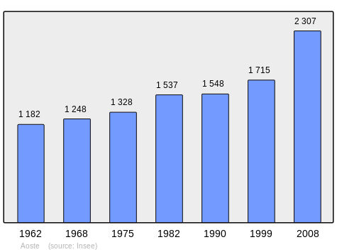
| 1962 | 1968 | 1975 | 1982 | 1990 | 1999 | 2006 | 2009 | - |
|---|---|---|---|---|---|---|---|---|
| 1,182 | 1,248 | 1,328 | 1,537 | 1,548 | 1,715 | 1,914 | 2,463 | - |
Sources : Ldh/EHESS/Cassini until 1962, INSEE database from 1968 (population without double counting and municipal population from 2006)
Economy
Jambon Aoste

The pork products produced in Isère department and especially the Jambon Aoste (Aoste Ham) are manufactured exclusively in this Groupe Aoste factory which was owned by the industrial group Sara Lee Corporation who ceased their activities in deli products and resold the operation to the American buyer Smithfield Foods through which it passed to the Chinese group Shuanghui in September 2013.
These industrial products with the "Jambon Aoste" label should not be confused with the official name "Vallée d’Aoste Jambon de Bosses" which is a ham produced in the Aosta Valley (An Italian/French Valley) and which has a protected designation of origin. The Ham products produced in Isère have a simple trademark and no Label Rouge, AOC or PDO regulates its production of cooked or raw ham, unlike the Italian Aosta ham which is a vintage handmade product made in very small quantities.[5]
Sites and Monuments
- An Ancient Roman settlement with an oven and many relics and an archaeological museum.[6]
- The School contains three items which are registered as historical objects:
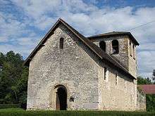
- The Chapel of Saint-Didier contains several items that are registered as historical objects:
Protected Natural Areas
The commune has two natural zones of ecological interest, fauna and flora of type I:[14]
- the alluvial areas of the Rhône du Pont de Groslée à Murs-et-Gélignieux
- the Pools of Paluette
See also
External links
- Aoste on the National Geographic Institute website (French)
- Aoste on Lion1906
- Aoste on Google Maps
- Aoste on Géoportail, National Geographic Institute (IGN) website (French)
- Aouste on the 1750 Cassini Map
- Aoste on the INSEE website (French)
- INSEE (French)
Notes and references
Notes
- ↑ At the beginning of the 21st century, the methods of identification have been modified by Law No. 2002-276 of 27 February 2002, the so-called "law of local democracy" and in particular Title V "census operations" allows, after a transitional period running from 2004 to 2008, the annual publication of the legal population of the different French administrative districts. For communes with a population greater than 10,000 inhabitants, a sample survey is conducted annually, the entire territory of these communes is taken into account at the end of the period of five years. The first "legal population" after 1999 under this new law came into force on 1 January 2009 and was based on the census of 2006.
References
- ↑ Inhabitants of Isère (French)
- 1 2 Google Maps
- ↑ Report on activity of Inrap in 2006, p. 112 (French)
- ↑ List of Mayors of France
- ↑ Jambon Aoste website (French)
- ↑ Museum website Archived July 9, 2009, at the Wayback Machine. (French)
- ↑ Ministry of Culture, Palissy PM38000007 Domestic Oratory
(French)

- ↑ Ministry of Culture, Palissy PM38000006 Altar (French)
- ↑ Ministry of Culture, Palissy PM38000005 2 Commemorative Plaques
(French)
- ↑ Ministry of Culture, Palissy PM38000612 Thurible
(French)
- ↑ Ministry of Culture, Palissy PM38000004 Processional Cross (French)
- ↑ Ministry of Culture, Palissy PM38000460 6 ex-voto Commemorative Plaques (French)
- ↑ Ministry of Culture, Palissy PM38000003 3 Funeral Plaques (French)
- ↑ Communal data portal, Regional Directorate of the Environment, Planning, and Housing (French)
| Wikimedia Commons has media related to Aoste (Isère). |