Allemond
| Allemond | |
|---|---|
 | |
 Allemond | |
|
Location within Auvergne-Rhône-Alpes region  Allemond | |
| Coordinates: 45°07′52″N 6°02′18″E / 45.1311°N 6.0383°ECoordinates: 45°07′52″N 6°02′18″E / 45.1311°N 6.0383°E | |
| Country | France |
| Region | Auvergne-Rhône-Alpes |
| Department | Isère |
| Arrondissement | Grenoble |
| Canton | Le Bourg-d'Oisans |
| Intercommunality | Oisans |
| Government | |
| • Mayor (2008–2020) | Alain Ginies |
| Area1 | 45 km2 (17 sq mi) |
| Population (2009)2 | 877 |
| • Density | 19/km2 (50/sq mi) |
| Time zone | CET (UTC+1) |
| • Summer (DST) | CEST (UTC+2) |
| INSEE/Postal code | 38005 / 38114 |
| Elevation | 702–2,969 m (2,303–9,741 ft) |
|
1 French Land Register data, which excludes lakes, ponds, glaciers > 1 km² (0.386 sq mi or 247 acres) and river estuaries. 2 Population without double counting: residents of multiple communes (e.g., students and military personnel) only counted once. | |
Allemond[1] (spelled Allemont by the local council[2]) is a French commune in the Isère department in the Rhône-Alpes region of south-eastern France.
The inhabitants of the commune are known as Allemondins or Allemondines[3]
Geography
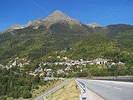
Allemond is a small mountain village in the heart of the Oisans in the valley of the Eau d'Olle, at the foot of the Belledonne mountains in the Grandes Rousses basin. It is located some 20 km east of Saint-Martin-d'Hères and 30 km south of Pontcharra. Access to the commune is by the D526 road from the south which passes through the village then continues north along the eastern border of the commune before turning west. The commune consists of high mountains with forests on the lower slopes.[4]
Localities and hamlets in the commune
- La traverse (1300 m high)
- Le clot
- La rivoire
- La combe
- Le Mas des Croze
- Le village
- Les grands champs
- La ville
- La fondrie
- La pernière haute et basse
- Pissevache
- Farnier
- Champeau
- Le villaret
- La drayrie
- Baton (700 m high)
- Coteysard
- Le Mollard
- Le Rivier
- L'eau Dolle
- Les 4 saisons
Neighbouring communes and villages[4]
 |
Les Adrets | La Ferrière | Saint-Sorlin-d'Arves | |
| Saint-Martin-d'Uriage | |
Vaujany | ||
| ||||
| | ||||
| Livet-et-Gavet | Le Bourg-d'Oisans | Huez |
History
The first buildings were built in the town in the Middle Ages.

Until the 1960s the life of the people was very simple: they were mainly farmers and herders.
The city also had mining activity under Louis XIII and Louis XIV. It housed the Royal foundries in which ore from mines in the town - mainly silver, lead, and copper - were melted down. Part of the buildings from the former royal foundry long housed the hotel called "Les Tilleuls" (now closed). This hotel with its beautiful walnut staircase was bought in 1920 by a former mayor of the town (for 40 years). His two daughters, Marguerite and Raymonde Giroutru, local personalities, then controlled the propertry for a long time. It was said that Napoleon III stayed at the hotel.
In the late 1970s, the Grand Maison Dam project was launched, it was an economic windfall for the commune and the whole region. The project lasted 10 years and brought in hundreds of workers.
The communes involved were able to invest in tourism and winter sports equipment so ensuring their future once the work was finished.
Today the commune lives completely on tourism both in summer and winter.
Administration
List of Successive Mayors[5]
| From | To | Name | Party | Position |
|---|---|---|---|---|
| 1989 | 2001 | Michel Roche | SE | |
| 2001 | 2020 | Alain Ginies | SE |
(Not all data is known)
Demography
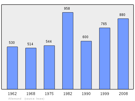
In 2009, the commune had 877 inhabitants. The evolution of the number of inhabitants is known through the population censuses conducted in the commune since 1793. From the 21st century, a census of communes with fewer than 10,000 inhabitants is held every five years, unlike larger towns that have a sample survey every year.[Note 1]
| 1793 | 1800 | 1806 | 1821 | 1831 | 1836 | 1841 | 1846 | 1851 |
|---|---|---|---|---|---|---|---|---|
| 1,012 | 1,169 | 1,184 | 1,017 | 1,275 | 1,353 | 1,546 | 1,527 | 1,555 |
| 1856 | 1861 | 1866 | 1872 | 1876 | 1881 | 1886 | 1891 | 1896 |
|---|---|---|---|---|---|---|---|---|
| 1,346 | 1,225 | 1,216 | 1,240 | 1,188 | 1,245 | 1,254 | 1,189 | 1,113 |
| 1901 | 1906 | 1911 | 1921 | 1926 | 1931 | 1936 | 1946 | 1954 |
|---|---|---|---|---|---|---|---|---|
| 1,102 | 1,146 | 970 | 954 | 826 | 804 | 737 | 654 | 587 |
| 1962 | 1968 | 1975 | 1982 | 1990 | 1999 | 2006 | 2009 | - |
|---|---|---|---|---|---|---|---|---|
| 530 | 514 | 544 | 958 | 600 | 765 | 854 | 877 | - |
Sources : Ldh/EHESS/Cassini until 1962, INSEE database from 1968 (population without double counting and municipal population from 2006)
Sites and monuments
Religious heritage
The Church contains a Bronze Bell (1657)![]() which is registered as an historical object.[6]
which is registered as an historical object.[6]
-

Allemond Church
-
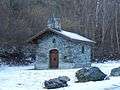
The Baton Chapel
Civil heritage
-
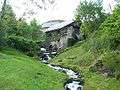
The Old Mill
-

The EDF Centre at Baton: Electricity plant dating from the beginning of the 20th century at an altitude of 1,300 metres
-

The Aiguille de l'Eau d'Olle, a climbing wall 30 metres high - the highest in Europe
- The Oven of faure
- The tower
See also
- Communes of the Isère department
- Cantons of the Isère department
- Arrondissements of the Isère department
External links
- Allemont official website (French)
- Allemond on Lion1906
- Allemond on Google Maps
- Allemond on Géoportail, National Geographic Institute (IGN) website (French)
- Allemont on the 1750 Cassini Map
- Allemond on the INSEE website (French)
- INSEE (French)
Notes and references
Notes
- ↑ At the beginning of the 21st century, the methods of identification have been modified by law No. 2002-276 of 27 February 2002 , the so-called "law of local democracy" and in particular Title V "census operations" which allow, after a transitional period running from 2004 to 2008, the annual publication of the legal population of the different French administrative districts. For municipalities with a population greater than 10,000 inhabitants, a sample survey is conducted annually, the entire territory of these municipalities is taken into account at the end of the period of five years. The first "legal population" after 1999 under this new law came into force on 1 January 2009 and was based on the census of 2006.
References
- ↑ Allemond on the INSEE website (French)
- ↑ Official Allemond website
- ↑ Inhabitants of Isère (French)
- 1 2 Google Maps
- ↑ List of Mayors of France
- ↑ Ministry of Culture, Palissy PM38000002 Bronze bell (French)
| Wikimedia Commons has media related to Allemont. |