Beaufin
| Beaufin | |
|---|---|
|
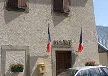
The Villeg - left is the Town Hall, right is the church | |
 Beaufin | |
|
Location within Auvergne-Rhône-Alpes region  Beaufin | |
| Coordinates: 44°47′19″N 5°57′39″E / 44.7886°N 5.9608°ECoordinates: 44°47′19″N 5°57′39″E / 44.7886°N 5.9608°E | |
| Country | France |
| Region | Auvergne-Rhône-Alpes |
| Department | Isère |
| Arrondissement | Grenoble |
| Canton | Corps |
| Intercommunality | Matheysine, Pays de Corps and Vallées du Valbonnais |
| Government | |
| • Mayor (2003–2020) | Emmanuel Serre |
| Area1 | 6 km2 (2 sq mi) |
| Population (2009)2 | 23 |
| • Density | 3.8/km2 (9.9/sq mi) |
| Time zone | CET (UTC+1) |
| • Summer (DST) | CEST (UTC+2) |
| INSEE/Postal code | 38031 / 38970 |
| Elevation | 744–2,080 m (2,441–6,824 ft) |
|
1 French Land Register data, which excludes lakes, ponds, glaciers > 1 km² (0.386 sq mi or 247 acres) and river estuaries. 2 Population without double counting: residents of multiple communes (e.g., students and military personnel) only counted once. | |

Beaufin is a French commune in the Isère department in the Auvergne-Rhône-Alpes region of south-eastern France.[1]
The inhabitants of the commune are known as Beaufinois or Beaufinoises.[2]
Geography

Beaufin is located some 50 km south by south-east of Grenoble and 25 km north by north-west of Gap. Access to the commune is by the D217 road from Ambel in the north-west which continues east across the river to join the Route nationale N85. The D57L from Le Glaizil in the south-east also passes through the commune and across the river without connecting to the road to the village. The only access to the village is by the D217A which branches off the D217 in the commune and is a dead-end road due to the collapse of a tunnel on the road leading south. The commune has three well-defined areas: in the west and south are the slopes of Mount Faraud with bare rock in the higher parts (over 1600 metres) and forests in their lower part; in the centre is a cultivated plain where the village is located; in the north and east the wooded slopes descend towards the River Drac.[3][4]
The Drac River forms the northern and eastern border of the commune with the upper reaches of the artificial Lac du Sautet to the north of the commune. The Drac river is also the departmental boundary with Hautes-Alpes until the south-eastern corner of the commune where the departmental border becomes the southern border of the commune. One small stream flows north from Mount Faraud, through the village and into Lake Sautet.[3][4]
Mapping
A list of online mapping systems can be displayed by clicking on the coordinates (latitude and longitude) in the top right hand corner of this article.
Neighbouring communes and villages
 |
Ambel | Aspres-lès-Corps | | |
| Pellafol | |
Saint-Firmin | ||
| ||||
| | ||||
| Le Glaizil | Chauffayer |
Toponymy
Beaufin appears as Baufin on the 1750 Cassini Map[5] and as Bausin on the 1790 version.[6]
Administration
| From | To | Name | Party | Position |
|---|---|---|---|---|
| 2001 | 2003 | Alphonse Bonthoux | ||
| 2003 | 2020 | Emmanuel Serre |
(Not all data is known)
Demography
In 2012 the commune had 999 inhabitants. The evolution of the number of inhabitants is known from the population censuses conducted in the commune since 1793. From the 21st century, a census of communes with fewer than 10,000 inhabitants is held every five years, unlike larger communes that have a sample survey every year.[Note 1]
| 1793 | 1800 | 1806 | 1821 | 1831 | 1836 | 1841 | 1846 | 1851 |
|---|---|---|---|---|---|---|---|---|
| 157 | 107 | 175 | 201 | 214 | 191 | 175 | 172 | 185 |
| 1856 | 1861 | 1866 | 1872 | 1876 | 1881 | 1886 | 1891 | 1896 |
|---|---|---|---|---|---|---|---|---|
| 172 | 174 | 171 | 171 | 151 | 160 | 139 | 122 | 119 |
| 1901 | 1906 | 1911 | 1921 | 1926 | 1931 | 1936 | 1946 | 1954 |
|---|---|---|---|---|---|---|---|---|
| 106 | 101 | 83 | 80 | 48 | 51 | 35 | 44 | 32 |
| 1962 | 1968 | 1975 | 1982 | 1990 | 1999 | 2007 | 2012 | - |
|---|---|---|---|---|---|---|---|---|
| 31 | 29 | 21 | 25 | 27 | 25 | - |
Sources : Ldh/EHESS/Cassini until 1962, INSEE database from 1968 (population without double counting and municipal population from 2006)


Sites and Monuments

- A Church from the 19th century with a unique nave, some marble in the interior (the altar, a foot stoup, a baptismal font)
- Remains of a castle from the early 15th century
- Red Rock lava flows.
See also
Notes and references
Notes
- ↑ At the beginning of the 21st century, the methods of identification have been modified by Law No. 2002-276 of 27 February 2002, the so-called "law of local democracy" and in particular Title V "census operations" allows, after a transitional period running from 2004 to 2008, the annual publication of the legal population of the different French administrative districts. For communes with a population greater than 10,000 inhabitants, a sample survey is conducted annually and the entire territory of these communes is taken into account at the end of the period of five years. The first "legal population" after 1999 under this new law came into force on 1 January 2009 and was based on the census of 2006.
References
- ↑ Beaufin on Lion1906
- ↑ Inhabitants of Isère (French)
- 1 2 3 Beaufin on Google Maps
- 1 2 Beaufin on the Géoportail from National Geographic Institute (IGN) website (French)
- ↑ Baufin on the 1750 Cassini Map
- ↑ Bausin on the 1790 Cassini Map
- ↑ List of Mayors of France (French)
| Wikimedia Commons has media related to Beaufin. |