Wright County, Minnesota
| Wright County, Minnesota | |
|---|---|
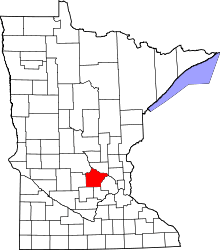 Location in the U.S. state of Minnesota | |
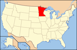 Minnesota's location in the U.S. | |
| Founded | February 20, 1855[1] |
| Named for | Silas Wright |
| Seat | Buffalo |
| Largest city | St. Michael |
| Area | |
| • Total | 714 sq mi (1,849 km2) |
| • Land | 661 sq mi (1,712 km2) |
| • Water | 53 sq mi (137 km2), 7.4% |
| Population (est.) | |
| • (2015) | 131,311 |
| • Density | 189/sq mi (73/km²) |
| Congressional district | 6th |
| Time zone | Central: UTC-6/-5 |
| Website |
www |
Wright County is a county located in the U.S. state of Minnesota. As of the 2010 census, the population was 124,700.[2] Its county seat is Buffalo.[3] The county was founded in 1855.
Wright County is included in the Minneapolis-St. Paul-Bloomington, MN-WI Metropolitan Statistical Area.
History
The county was established in 1855, and was named after New York politician Silas Wright.[4] The first county seat was Monticello; in 1868 the county seat was changed to Buffalo. The majority of people to first settle this area were German and Swedish. The population of the county in 1860 was 3,729 people; in 1875, it was 13,775.[5]
The 1998 thriller A Simple Plan was set in Wright County, though no specific town is mentioned.
Geography
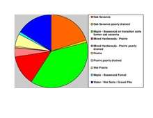
According to the U.S. Census Bureau, the county has a total area of 714 square miles (1,850 km2), of which 661 square miles (1,710 km2) is land and 53 square miles (140 km2) (7.4%) is water.[6] The terrain is undulating and contains numerous small lakes. The county is bounded on the northeast by the Mississippi River.[5] Wright is one of 17 Minnesota savanna region counties with more savanna soils than either prairie or forest soils, and one of only two Minnesota counties where savanna soils make up more than 75% of the county area (the other is Hennepin County).

Major highways
Adjacent counties
- Sherburne County (northeast)
- Hennepin County (east)
- Carver County (southeast)
- McLeod County (southwest)
- Meeker County (west)
- Stearns County (northwest)
Demographics
| Historical population | |||
|---|---|---|---|
| Census | Pop. | %± | |
| 1860 | 3,729 | — | |
| 1870 | 9,457 | 153.6% | |
| 1880 | 18,104 | 91.4% | |
| 1890 | 24,164 | 33.5% | |
| 1900 | 29,157 | 20.7% | |
| 1910 | 28,082 | −3.7% | |
| 1920 | 28,685 | 2.1% | |
| 1930 | 27,119 | −5.5% | |
| 1940 | 27,550 | 1.6% | |
| 1950 | 27,716 | 0.6% | |
| 1960 | 29,935 | 8.0% | |
| 1970 | 38,933 | 30.1% | |
| 1980 | 58,681 | 50.7% | |
| 1990 | 68,710 | 17.1% | |
| 2000 | 89,986 | 31.0% | |
| 2010 | 122,700 | 36.4% | |
| Est. 2015 | 131,311 | [8] | 7.0% |
| U.S. Decennial Census[9] 1790–1960[10] 1900–1990[11] 1990–2000[12] 2010–2015[2] | |||

2010
The ethnic makeup of the county, according to the 2010 U.S. Census, was the following:
- 95.04% White
- 1.06% Black
- 0.34% Native American
- 1.19% Asian
- 0.04% Native Hawaiian or Pacific Islander
- 1.53% Two or more races
- 0.81% Other races
- 2.45% Hispanic or Latino (of any race)
2000
As of the census of 2000, there were 89,986 people, 31,465 households, and 23,913 families residing in the county. The population density was 136 people per square mile (53/km²). There were 34,355 housing units at an average density of 52 per square mile (20/km²). The racial makeup of the county was 97.85% White, 0.26% Black or African American, 0.28% Native American, 0.44% Asian, 0.01% Pacific Islander, 0.36% from other races, and 0.80% from two or more races. 1.10% of the population were Hispanic or Latino of any race. 42.3% were of German, 11.9% Norwegian, 7.4% Swedish and 6.6% Irish ancestry.
There were 31,465 households out of which 42.10% had children under the age of 18 living with them, 64.50% were married couples living together, 7.70% had a female householder with no husband present, and 24.00% were non-families. 18.80% of all households were made up of individuals and 6.80% had someone living alone who was 65 years of age or older. The average household size was 2.83 and the average family size was 3.26.
In the county the population was spread out with 31.10% under the age of 18, 7.60% from 18 to 24, 32.60% from 25 to 44, 19.90% from 45 to 64, and 8.80% who were 65 years of age or older. The median age was 33 years. For every 100 females there were 101.40 males. For every 100 females age 18 and over, there were 99.90 males.
The median income for a household in the county was $53,945, and the median income for a family was $60,940. Males had a median income of $40,630 versus $28,201 for females. The per capita income for the county was $21,844. About 3.60% of families and 4.70% of the population were below the poverty line, including 5.50% of those under age 18 and 7.40% of those age 65 or over.
Politics
| Year | Democratic | Republican |
|---|---|---|
| 2016 | 29.4% 20,336 | 62.6% 43,274 |
| 2012 | 38.2% 26,584 | 59.6% 41,460 |
| 2008 | 40.7% 26,343 | 57.6% 37,779 |
| 2004 | 38.0% 22,618 | 60.8% 36,176 |
| 2000 | 38.7% 16,762 | 55.0% 23,861 |
Communities
Cities
Townships
Unincorporated communities
Ghost town
See also
References
- ↑ "Minnesota Place Names". Minnesota Historical Society. Retrieved March 19, 2014.
- 1 2 "State & County QuickFacts". United States Census Bureau. Retrieved September 1, 2013.
- ↑ "Find a County". National Association of Counties. Retrieved 2011-06-07.
- ↑ Upham, Warren (1920). Minnesota Geographic Names: Their Origin and Historic Significance. Minnesota Historical Society. p. 586.
- 1 2
 Ripley, George; Dana, Charles A., eds. (1879). "Wright. I. A central county of Minnesota". The American Cyclopædia.
- ↑ "2010 Census Gazetteer Files". United States Census Bureau. August 22, 2012. Retrieved October 25, 2014.
- ↑ Nelson, Steven (2011). Savanna Soils of Minnesota. Minnesota: Self. pp. 49–52. ISBN 978-0-615-50320-2.
- ↑ "County Totals Dataset: Population, Population Change and Estimated Components of Population Change: April 1, 2010 to July 1, 2015". Retrieved July 2, 2016.
- ↑ "U.S. Decennial Census". United States Census Bureau. Retrieved October 25, 2014.
- ↑ "Historical Census Browser". University of Virginia Library. Retrieved October 25, 2014.
- ↑ "Population of Counties by Decennial Census: 1900 to 1990". United States Census Bureau. Retrieved October 25, 2014.
- ↑ "Census 2000 PHC-T-4. Ranking Tables for Counties: 1990 and 2000" (PDF). United States Census Bureau. Retrieved October 25, 2014.
External links
 |
Stearns County | Sherburne County | | |
| Meeker County | |
Hennepin County | ||
| ||||
| | ||||
| McLeod County | Carver County |
Municipalities and communities of Wright County, Minnesota, United States | ||
|---|---|---|
| Cities | | |
| Townships | ||
| CDP | ||
| Unincorporated communities | ||
| Ghost town | ||
| Footnotes | ‡This populated place also has portions in an adjacent county or counties | |
Coordinates: 45°11′N 93°58′W / 45.18°N 93.97°W