Maplewood, Minnesota
| Maplewood, Minnesota | |
|---|---|
| City | |
 Location of the city of Maplewood within Ramsey County, Minnesota | |
| Coordinates: 44°59′34″N 93°1′26″W / 44.99278°N 93.02389°W | |
| Country | United States |
| State | Minnesota |
| County | Ramsey |
| Government | |
| • Mayor | Nora Slawik |
| Area[1] | |
| • Total | 17.99 sq mi (46.59 km2) |
| • Land | 16.98 sq mi (43.98 km2) |
| • Water | 1.01 sq mi (2.62 km2) |
| Elevation | 978 ft (298 m) |
| Population (2010)[2] | |
| • Total | 38,018 |
| • Estimate (2015)[3] | 40,567 |
| • Density | 2,239.0/sq mi (864.5/km2) |
| Time zone | Central (CST) (UTC-6) |
| • Summer (DST) | CDT (UTC-5) |
| ZIP codes | 55106, 55109, 55117, 55119 |
| Area code(s) | 651 |
| FIPS code | 27-40382 |
| GNIS feature ID | 0647503[4] |
| Website | www.ci.maplewood.mn.us |

Maplewood, incorporated in 1957, is a city in Ramsey County, Minnesota, United States. The population was 38,018 at the 2010 census.[5] Maplewood is ten minutes from downtown Saint Paul. Maplewood stretches along most of the northern and eastern borders of Saint Paul.
Maplewood is home to the corporate headquarters and main campus of 3M Corporation. The city is also home to the Maplewood Mall and St. John's Hospital.
Geography
According to the United States Census Bureau, the city has a total area of 17.99 square miles (46.59 km2), of which 16.98 square miles (43.98 km2) is land and 1.01 square miles (2.62 km2) is water.[1]
U.S. Highway 61, Minnesota Highway 36, and Interstate Highways 35E, 94, 694, and 494 are six of the main routes in the city.
Demographics
| Historical population | |||
|---|---|---|---|
| Census | Pop. | %± | |
| 1960 | 18,519 | — | |
| 1970 | 25,186 | 36.0% | |
| 1980 | 26,990 | 7.2% | |
| 1990 | 30,954 | 14.7% | |
| 2000 | 34,947 | 12.9% | |
| 2010 | 38,018 | 8.8% | |
| Est. 2015 | 40,567 | [6] | 6.7% |
2015 Estimate[3] | |||
2010 census
As of the census[2] of 2010, there were 38,018 people, 14,882 households, and 9,620 families residing in the city. The population density was 2,239.0 inhabitants per square mile (864.5/km2). There were 15,561 housing units at an average density of 916.4 per square mile (353.8/km2). The racial makeup of the city was 75.5% White, 8.2% African American, 0.5% Native American, 10.4% Asian, 0.1% Pacific Islander, 2.4% from other races, and 2.9% from two or more races. Hispanic or Latino of any race were 6.2% of the population.
There were 14,882 households of which 30.3% had children under the age of 18 living with them, 47.8% were married couples living together, 12.1% had a female householder with no husband present, 4.7% had a male householder with no wife present, and 35.4% were non-families. 29.1% of all households were made up of individuals and 12.5% had someone living alone who was 65 years of age or older. The average household size was 2.48 and the average family size was 3.08.
The median age in the city was 39.3 years. 22.9% of residents were under the age of 18; 9% were between the ages of 18 and 24; 25.2% were from 25 to 44; 27.7% were from 45 to 64; and 15.2% were 65 years of age or older. The gender makeup of the city was 48.0% male and 52.0% female.
2000 census
As of the census of 2000, there were 34,947 people, 13,758 households, and 9,190 families residing in the city. The population density was 2,017.5 people per square mile (779.0/km²). There were 14,004 housing units at an average density of 808.5 per square mile (312.2/km²). The racial makeup of the city was 72.6% White, 8.0% African American, 0.4% Native American, 10.4% Asian, 0.03% Pacific Islander, 0.08% from other races, and 2.4% from two or more races. Hispanic or Latino of any race were 6.2% of the population.
There were 13,758 households out of which 31.6% had children under the age of 18 living with them, 52.8% were married couples living together, 10.5% had a female householder with no husband present, and 33.2% were non-families. 27.0% of all households were made up of individuals and 11.1% had someone living alone who was 65 years of age or older. The average household size was 2.48 and the average family size was 3.04.
In the city the population was spread out with 24.7% under the age of 18, 7.7% from 18 to 24, 30.0% from 25 to 44, 22.6% from 45 to 64, and 15.0% who were 65 years of age or older. The median age was 38 years. For every 100 females there were 91.5 males. For every 100 females age 18 and over, there were 87.8 males.
The median income for a household in the city was $51,596, and the median income for a family was $63,049. Males had a median income of $43,033 versus $30,557 for females. The per capita income for the city was $24,387. About 3.0% of families and 4.8% of the population were below the poverty line, including 4.9% of those under age 18 and 5.6% of those age 65 or over.
The current city council includes the following five members:
| Office | Member | First elected | District |
|---|---|---|---|
| Mayor | Nora Slawik | 2014 | At Large |
| Council member | Kathleen Juenemann | 2001 | At Large |
| Council member | Bryan Smith | 2016 | At Large |
| Council member | Marylee Abrams | 2014 | At Large |
| Council member | Tou Xiong | 2016 | At Large |
Economy
According to the City's 2011 Comprehensive Annual Financial Report,[8] the top employers in the city are:
| # | Employer | # of Employees |
|---|---|---|
| 1 | 3M | 10,000 |
| 2 | Independent School District 622 | 1,558 |
| 3 | St. John's Hospital | 1,500 |
| 4 | City of Maplewood | 552 |
| 5 | Healthstar Home Health | 550 |
| 6 | Cub Foods (two locations) | 265 |
| 7 | Ramsey County Nursing Home | 260 |
| 8 | Volunteers of America - Maplewood Campus | 240 |
| 9 | Home Depot | 200 |
| 10 | Menards | 200 |
References
- 1 2 "US Gazetteer files 2010". United States Census Bureau. Retrieved 2012-11-13.
- 1 2 "American FactFinder". United States Census Bureau. Retrieved 2012-11-13.
- 1 2 "Population Estimates". United States Census Bureau. Retrieved June 7, 2016.
- ↑ "US Board on Geographic Names". United States Geological Survey. 2007-10-25. Retrieved 2008-01-31.
- ↑ "2010 Census Redistricting Data (Public Law 94-171) Summary File". American FactFinder. U.S. Census Bureau, 2010 Census. Retrieved 23 April 2011.
- ↑ "Annual Estimates of the Resident Population for Incorporated Places: April 1, 2010 to July 1, 2015". Retrieved July 2, 2016.
- ↑ United States Census Bureau. "Census of Population and Housing". Retrieved August 14, 2013.
- ↑ http://www.ci.maplewood.mn.us/DocumentView.aspx?DID=2437
Municipalities and communities of Ramsey County, Minnesota, United States | ||
|---|---|---|
| Cities | 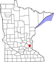 | |
| Township | ||
| Unincorporated communities | ||
| Footnotes | ‡This populated place also has portions in an adjacent county or counties | |
Coordinates: 44°57′11″N 92°59′43″W / 44.95306°N 92.99528°W