Todd County, Minnesota
| Todd County, Minnesota | |
|---|---|
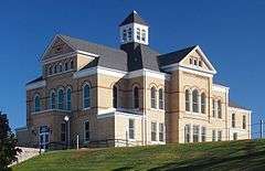 The Todd County Courthouse in Long Prairie | |
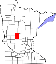 Location in the U.S. state of Minnesota | |
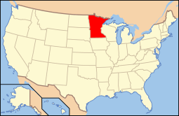 Minnesota's location in the U.S. | |
| Founded |
February 20, 1855 (created) 1867 (organized)[1] |
| Named for | John Blair Smith Todd |
| Seat | Long Prairie |
| Largest city | Long Prairie |
| Area | |
| • Total | 980 sq mi (2,538 km2) |
| • Land | 945 sq mi (2,448 km2) |
| • Water | 35 sq mi (91 km2), 3.5% |
| Population (est.) | |
| • (2015) | 24,257 |
| • Density | 26/sq mi (10/km²) |
| Congressional district | 7th |
| Time zone | Central: UTC-6/-5 |
| Website |
www |
Todd County is a county in the U.S. state of Minnesota. As of the 2010 census, the population was 24,895.[3] Its county seat is Long Prairie.[4] The county was formed in 1855 and organized in 1867. It is named after John Blair Smith Todd, who was a delegate from Dakota Territory to the United States House of Representatives, and general in the Union Army during the American Civil War.[5]
Geography
According to the U.S. Census Bureau, the county has a total area of 980 square miles (2,500 km2), of which 945 square miles (2,450 km2) is land and 35 square miles (91 km2) (3.5%) is water.[6]
Major highways
Adjacent counties
- Wadena County (north)
- Cass County (northeast)
- Morrison County (east)
- Stearns County (south)
- Douglas County (west)
- Otter Tail County (northwest)
Demographics
| Historical population | |||
|---|---|---|---|
| Census | Pop. | %± | |
| 1860 | 430 | — | |
| 1870 | 2,036 | 373.5% | |
| 1880 | 6,133 | 201.2% | |
| 1890 | 12,930 | 110.8% | |
| 1900 | 22,214 | 71.8% | |
| 1910 | 23,407 | 5.4% | |
| 1920 | 26,059 | 11.3% | |
| 1930 | 26,170 | 0.4% | |
| 1940 | 27,438 | 4.8% | |
| 1950 | 25,420 | −7.4% | |
| 1960 | 23,119 | −9.1% | |
| 1970 | 22,114 | −4.3% | |
| 1980 | 24,991 | 13.0% | |
| 1990 | 23,363 | −6.5% | |
| 2000 | 24,426 | 4.5% | |
| 2010 | 24,895 | 1.9% | |
| Est. 2015 | 24,257 | [7] | −2.6% |
| U.S. Decennial Census[8] 1790-1960[9] 1900-1990[10] 1990-2000[11] 2010-2015[3] | |||
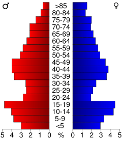
As of the census of 2000,[12] there were 24,426 people, 9,342 households, and 6,511 families in Todd County. The population density was 26 people per square mile (10/km²). There were 11,900 housing units at an average density of 13 per square mile (5/km²). The racial makeup of the county was 97.54% White, 0.11% Black or African American, 0.48% Native American, 0.31% Asian, 0.01% Pacific Islander, 0.72% from other races, and 0.82% from two or more races. 1.90% of the population were Hispanic or Latino of any race. 52.1% were of German, 11.3% Norwegian and 5.6% Polish ancestry.
There were 9,342 households out of which 31.80% had children under the age of 18 living with them, 59.80% were married couples living together, 6.10% had a female householder with no husband present, and 30.30% were non-families. 26.30% of all households were made up of individuals and 13.00% had someone living alone who was 65 years of age or older. The average household size was 2.58 and the average family size was 3.14.
In the county the population was spread out with 27.40% under the age of 18, 8.10% from 18 to 24, 24.70% from 25 to 44, 23.80% from 45 to 64, and 16.10% who were 65 years of age or older. The median age was 38 years. For every 100 females there were 101.80 males. For every 100 females age 18 and over, there were 102.00 males.
The median income for a household in the county was $32,281, and the median income for a family was $39,920. Males had a median income of $28,630 versus $20,287 for females. The per capita income for the county was $15,658. About 9.60% of families and 12.90% of the population were below the poverty line, including 14.60% of those under age 18 and 13.50% of those age 65 or over.
Amish
Todd County has a large concentration of Amish, about the same population size as the Amish settlement at Harmony, Minnesota.[13] It is home to five different Amish communities, with altogether 7 church districts in 2013, which indicates a total population of about 1000 people.
| Location | Founded in | Church dis- tricts in 2013 |
Affiation |
|---|---|---|---|
| Bertha/Hewitt | 1973 | 1 | Swartzentruber |
| Long Prairie/Osakis | 1995 | 2 | |
| Clarissa/Browerville | 2001 | 2 | |
| Bertha/Staples | 2003 | 1 | Swartzentruber |
| Eagle Bend | 2007 | 1 |
Communities
Cities
- Bertha
- Browerville
- Burtrum
- Clarissa
- Eagle Bend
- Grey Eagle
- Hewitt
- Long Prairie (county seat)
- Osakis (partly in Douglas County)
- Staples (partly in Wadena County)
- West Union
Townships
Unincorporated communities
See also
References
- ↑ "Minnesota Place Names". Minnesota Historical Society. Retrieved March 19, 2014.
- ↑ Nelson, Steven (2011). Savanna Soils of Minnesota. Minnesota: Self. pp. 53 56. ISBN 978-0-615-50320-2.
- 1 2 "State & County QuickFacts". United States Census Bureau. Retrieved September 1, 2013.
- ↑ "Find a County". National Association of Counties. Retrieved 2011-06-07.
- ↑ Upham, Warren (1920). Minnesota Geographic Names: Their Origin and Historic Significance. Minnesota Historical Society. p. 543.
- ↑ "2010 Census Gazetteer Files". United States Census Bureau. August 22, 2012. Retrieved October 25, 2014.
- ↑ "County Totals Dataset: Population, Population Change and Estimated Components of Population Change: April 1, 2010 to July 1, 2015". Retrieved July 2, 2016.
- ↑ "U.S. Decennial Census". United States Census Bureau. Retrieved October 25, 2014.
- ↑ "Historical Census Browser". University of Virginia Library. Retrieved October 25, 2014.
- ↑ "Population of Counties by Decennial Census: 1900 to 1990". United States Census Bureau. Retrieved October 25, 2014.
- ↑ "Census 2000 PHC-T-4. Ranking Tables for Counties: 1990 and 2000" (PDF). United States Census Bureau. Retrieved October 25, 2014.
- ↑ "American FactFinder". United States Census Bureau. Retrieved 2008-01-31.
- ↑ [amishamerica.com/minnesota-amish/ "Minnesota Amish" at amishamerica.com]
- ↑ Joseph F. Donnermeyer and David Luthy: Amish Settlements across America 2013 in Journal of Amish and Plain Anabaptist Studies
External links
 |
Otter Tail County | Wadena County | Cass County | |
| Douglas County | |
Morrison County | ||
| ||||
| | ||||
| Stearns County |
Municipalities and communities of Todd County, Minnesota, United States | ||
|---|---|---|
| Cities | | |
| Townships | ||
| Unincorporated communities | ||
| Footnotes | ‡This populated place also has portions in an adjacent county or counties | |
Coordinates: 46°04′N 94°54′W / 46.07°N 94.90°W