Douglas County, Minnesota
| Douglas County, Minnesota | |
|---|---|
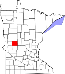 Location in the U.S. state of Minnesota | |
 Minnesota's location in the U.S. | |
| Founded |
March 8, 1858 (created) 1866 (organized)[1] |
| Named for | Stephen Douglas |
| Seat | Alexandria |
| Largest city | Alexandria |
| Area | |
| • Total | 720 sq mi (1,865 km2) |
| • Land | 637 sq mi (1,650 km2) |
| • Water | 83 sq mi (215 km2), 11% |
| Population (est.) | |
| • (2015) | 37,075 |
| • Density | 57/sq mi (22/km²) |
| Congressional district | 7th |
| Time zone | Central: UTC-6/-5 |
| Website |
www |
Douglas County is a county located in the U.S. state of Minnesota. As of the 2010 census, the population was 36,009.[2] Its county seat is Alexandria.[3] Douglas County was established in 1858. It is named for Stephen Douglas,[4] of Illinois. The county was formed in 1858 and organized in 1866.
Douglas County comprises the Alexandria, MN Micropolitan Statistical Area.
Douglas County is the home of Minnesota's only wine-grape appellation, the 10,880 acres (44.0 km2) Alexandria Lakes AVA.
Geography
According to the U.S. Census Bureau, the county has a total area of 720 square miles (1,900 km2), of which 637 square miles (1,650 km2) is land and 83 square miles (210 km2) (11%) is water.[5] It contains more than 250 lakes.
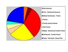
The county includes two of Minnesota's biomes: prairie grassland in the west and southeast, savannas (also prairie ecosystems) in the middle, and temperate deciduous forest in the south-central, north, and east.[6]
Douglas is one of 17 Minnesota counties where savanna soils dominate.
Adjacent counties
- Otter Tail County (north)
- Todd County (east)
- Stearns County (southeast)
- Pope County (south)
- Stevens County (southwest)
- Grant County (west)
Demographics
| Historical population | |||
|---|---|---|---|
| Census | Pop. | %± | |
| 1870 | 4,239 | — | |
| 1880 | 9,130 | 115.4% | |
| 1890 | 14,606 | 60.0% | |
| 1900 | 17,964 | 23.0% | |
| 1910 | 17,669 | −1.6% | |
| 1920 | 19,039 | 7.8% | |
| 1930 | 18,813 | −1.2% | |
| 1940 | 20,369 | 8.3% | |
| 1950 | 21,304 | 4.6% | |
| 1960 | 21,313 | 0.0% | |
| 1970 | 22,892 | 7.4% | |
| 1980 | 27,839 | 21.6% | |
| 1990 | 28,839 | 3.6% | |
| 2000 | 32,821 | 13.8% | |
| 2010 | 36,009 | 9.7% | |
| Est. 2015 | 37,075 | [8] | 3.0% |
| U.S. Decennial Census[9] 1790-1960[10] 1900-1990[11] 1990-2000[12] 2010-2015[2] | |||
As of the census of 2000,[13] there were 32,821 people, 13,276 households, and 9,027 families residing in the county. The population density was 52 people per square mile (20/km²). There were 16,694 housing units at an average density of 26 per square mile (10/km²). The racial makeup of the county was 98.49% White, 0.18% Black or African American, 0.24% Native American, 0.40% Asian, 0.03% Pacific Islander, 0.18% from other races, and 0.48% from two or more races. 0.59% of the population were Hispanic or Latino of any race. 38.5% were of German, 24.6% Norwegian and 8.1% Swedish ancestry.

There were 13,276 households out of which 29.90% had children under the age of 18 living with them, 59.00% were married couples living together, 6.40% had a female householder with no husband present, and 32.00% were non-families. 26.50% of all households were made up of individuals and 12.30% had someone living alone who was 65 years of age or older. The average household size was 2.42 and the average family size was 2.93.
In the county the population was spread out with 24.00% under the age of 18, 9.20% from 18 to 24, 25.00% from 25 to 44, 23.80% from 45 to 64, and 17.90% who were 65 years of age or older. The median age was 40 years. For every 100 females there were 99.00 males. For every 100 females age 18 and over, there were 96.90 males.
The median income for a household in the county was $37,703, and the median income for a family was $46,250. Males had a median income of $30,968 versus $21,240 for females. The per capita income for the county was $18,850. About 5.60% of families and 8.50% of the population were below the poverty line, including 9.30% of those under age 18 and 11.00% of those age 65 or over.
Transportation
Major highways
Airports
Alexandria Municipal Airport, also known as Chandler Field, is a city-owned public-use airport located two nautical miles (3.7 km) southwest of the central business district of Alexandria, a city in Douglas County.
Communities
Cities
- Alexandria (county seat)
- Brandon
- Carlos
- Evansville
- Forada
- Garfield
- Kensington
- Millerville
- Miltona
- Nelson
- Osakis (partly in Todd County)
Townships
- Alexandria Township
- Belle River Township
- Brandon Township
- Carlos Township
- Evansville Township
- Holmes City Township
- Hudson Township
- Ida Township
- La Grand Township
- Lake Mary Township
- Leaf Valley Township
- Lund Township
- Millerville Township
- Miltona Township
- Moe Township
- Orange Township
- Osakis Township
- Solem Township
- Spruce Hill Township
- Urness Township
Unincorporated community
See also
References
- ↑ "Minnesota Place Names". Minnesota Historical Society. Retrieved March 18, 2014.
- 1 2 "State & County QuickFacts". United States Census Bureau. Retrieved August 31, 2013.
- ↑ "Find a County". National Association of Counties. Retrieved 2011-06-07.
- ↑ Gannett, Henry (1905). The Origin of Certain Place Names in the United States. Govt. Print. Off. p. 108.
- ↑ "2010 Census Gazetteer Files". United States Census Bureau. August 22, 2012. Retrieved October 15, 2014.
- ↑ "Minnesota's Biomes" (PDF). Minnesota Department of Natural Resources. 2008. Retrieved 2010-02-27.
- ↑ Nelson, Steven (2011). Savanna Soils of Minnesota. Minnesota: Self. pp. 53 - 56. ISBN 978-0-615-50320-2.
- ↑ "County Totals Dataset: Population, Population Change and Estimated Components of Population Change: April 1, 2010 to July 1, 2015". Retrieved July 2, 2016.
- ↑ "U.S. Decennial Census". United States Census Bureau. Retrieved October 15, 2014.
- ↑ "Historical Census Browser". University of Virginia Library. Retrieved October 15, 2014.
- ↑ "Population of Counties by Decennial Census: 1900 to 1990". United States Census Bureau. Retrieved October 15, 2014.
- ↑ "Census 2000 PHC-T-4. Ranking Tables for Counties: 1990 and 2000" (PDF). United States Census Bureau. Retrieved October 15, 2014.
- ↑ "American FactFinder". United States Census Bureau. Retrieved 2008-01-31.
External links
- Douglas County government’s website
- Alexandria Area Economic Development Commission's website
- Douglas County, MN Area Manufacturing & Healthcare Opportunities
 |
Otter Tail County | | ||
| Grant County | |
Todd County | ||
| ||||
| | ||||
| Stevens County | Pope County | Stearns County |
Municipalities and communities of Douglas County, Minnesota, United States | ||
|---|---|---|
| Cities | | |
| Townships | ||
| Unincorporated communities | ||
| Footnotes | ‡This populated place also has portions in an adjacent county or counties | |
Coordinates: 45°56′N 95°27′W / 45.94°N 95.45°W