Waverly, Minnesota
| Waverly, Minnesota | |
|---|---|
| City | |
|
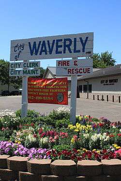
Waverly City Offices | |
 Location of the city of Waverly within Wright County, Minnesota | |
| Coordinates: 45°4′3″N 93°58′4″W / 45.06750°N 93.96778°W | |
| Country | United States |
| State | Minnesota |
| County | Wright |
| Area[1] | |
| • Total | 2.55 sq mi (6.60 km2) |
| • Land | 1.69 sq mi (4.38 km2) |
| • Water | 0.86 sq mi (2.23 km2) |
| Elevation | 1,007 ft (307 m) |
| Population (2010)[2] | |
| • Total | 1,357 |
| • Estimate (2012[3]) | 1,376 |
| • Density | 803.0/sq mi (310.0/km2) |
| Time zone | Central (CST) (UTC-6) |
| • Summer (DST) | CDT (UTC-5) |
| ZIP code | 55390 |
| Area code(s) | 763 |
| FIPS code | 27-68764[4] |
| GNIS feature ID | 0653859[5] |
| Website | www.waverlymn.org |
Waverly is a city in Wright County, Minnesota, United States. The population was 1,357 at the 2010 census.[6]
History
Waverly was laid out in 1869 when the Saint Paul and Pacific Railroad was extended to that point.[7] The city was named after Waverly, New York.[7] A post office has been in operation at Waverly since 1869.[8] Waverly was incorporated in 1881.[7] The 1939 Waverly Village Hall is listed on the National Register of Historic Places.[9]
Geography
According to the United States Census Bureau, the city has a total area of 2.55 square miles (6.60 km2); 1.69 square miles (4.38 km2) is land and 0.86 square miles (2.23 km2) is water.[1]
U.S. Highway 12 serves as a main route in the community.
Demographics
| Historical population | |||
|---|---|---|---|
| Census | Pop. | %± | |
| 1880 | 124 | — | |
| 1890 | 370 | 198.4% | |
| 1900 | 542 | 46.5% | |
| 1910 | 460 | −15.1% | |
| 1920 | 418 | −9.1% | |
| 1930 | 458 | 9.6% | |
| 1940 | 458 | 0.0% | |
| 1950 | 493 | 7.6% | |
| 1960 | 574 | 16.4% | |
| 1970 | 573 | −0.2% | |
| 1980 | 470 | −18.0% | |
| 1990 | 600 | 27.7% | |
| 2000 | 732 | 22.0% | |
| 2010 | 1,357 | 85.4% | |
| Est. 2015 | 1,396 | [10] | 2.9% |
2010 census
As of the census[2] of 2010, there were 1,357 people, 520 households, and 357 families residing in the city. The population density was 803.0 inhabitants per square mile (310.0/km2). There were 603 housing units at an average density of 356.8 per square mile (137.8/km2). The racial makeup of the city was 97.3% White, 0.5% African American, 0.4% Native American, 0.8% Asian, 0.1% from other races, and 1.0% from two or more races. Hispanic or Latino of any race were 1.3% of the population.
There were 520 households of which 37.1% had children under the age of 18 living with them, 56.2% were married couples living together, 7.1% had a female householder with no husband present, 5.4% had a male householder with no wife present, and 31.3% were non-families. 24.0% of all households were made up of individuals and 6.1% had someone living alone who was 65 years of age or older. The average household size was 2.53 and the average family size was 3.03.
The median age in the city was 31.6 years. 26.6% of residents were under the age of 18; 7.6% were between the ages of 18 and 24; 37.6% were from 25 to 44; 20.1% were from 45 to 64; and 8.2% were 65 years of age or older. The gender makeup of the city was 53.7% male and 46.3% female.
2000 census
As of the census[4] of 2000, there were 732 people, 284 households, and 197 families residing in the city. The population density was 879.9 people per square mile (340.5/km²). There were 332 housing units at an average density of 399.1 per square mile (154.4/km²). The racial makeup of the city was 99.18% White, 0.14% African American, 0.27% Asian, and 0.41% from two or more races. Hispanic or Latino of any race were 0.27% of the population.
There were 284 households out of which 34.9% had children under the age of 18 living with them, 55.3% were married couples living together, 9.5% had a female householder with no husband present, and 30.3% were non-families. 25.4% of all households were made up of individuals and 11.3% had someone living alone who was 65 years of age or older. The average household size was 2.58 and the average family size was 3.06.
In the city the population was spread out with 27.2% under the age of 18, 5.2% from 18 to 24, 35.1% from 25 to 44, 19.9% from 45 to 64, and 12.6% who were 65 years of age or older. The median age was 35 years. For every 100 females there were 96.8 males. For every 100 females age 18 and over, there were 98.1 males.
The median income for a household in the city was $52,000, and the median income for a family was $57,750. Males had a median income of $39,917 versus $25,815 for females. The per capita income for the city was $22,552. About 1.1% of families and 4.2% of the population were below the poverty line, including 2.5% of those under age 18 and 8.3% of those age 65 or over.
Notable Person
- Hubert Humphrey (1911–1978), American politician who served as the 38th Vice President of the United States from 1965 to 1969. Humphrey twice served as a U.S. Senator, representing Minnesota from 1949 to 1964, and 1971 to 1978. In 1958 Humphrey and his wife Muriel built a lakefront home in Waverly; it served as his primary residence for the rest of his life, and he died there in 1978. Waverly's elementary school is named after Vice President Humphrey.
References
- 1 2 "US Gazetteer files 2010". United States Census Bureau. Retrieved 2012-11-13.
- 1 2 "American FactFinder". United States Census Bureau. Retrieved 2012-11-13.
- ↑ "Population Estimates". United States Census Bureau. Retrieved 2013-05-28.
- 1 2 "American FactFinder". United States Census Bureau. Retrieved 2008-01-31.
- ↑ "US Board on Geographic Names". United States Geological Survey. 2007-10-25. Retrieved 2008-01-31.
- ↑ "2010 Census Redistricting Data (Public Law 94-171) Summary File". American FactFinder. U.S. Census Bureau, 2010 Census. Retrieved 23 April 2011.
- 1 2 3 Upham, Warren (1920). Minnesota Geographic Names: Their Origin and Historic Significance. Minnesota Historical Society. p. 589.
- ↑ "Wright County". Jim Forte Postal History. Retrieved 1 August 2015.
- ↑ National Park Service (2010-07-09). "National Register Information System". National Register of Historic Places. National Park Service.
- ↑ "Annual Estimates of the Resident Population for Incorporated Places: April 1, 2010 to July 1, 2015". Retrieved July 2, 2016.
- ↑ "Census of Population and Housing". Census.gov. Retrieved June 4, 2015.
External links
| Wikimedia Commons has media related to Waverly, Minnesota. |
Municipalities and communities of Wright County, Minnesota, United States | ||
|---|---|---|
| Cities | 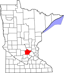 | |
| Townships | ||
| CDP | ||
| Unincorporated communities | ||
| Ghost town | ||
| Footnotes | ‡This populated place also has portions in an adjacent county or counties | |
Coordinates: 45°04′00″N 93°57′59″W / 45.06667°N 93.96639°W