TD postcode area
Postcode district boundaries: Bing / Google
| Galashiels postcode area | |
|---|---|
 TD | |
| Postcode area | TD |
| Postcode area name | Galashiels |
| Post towns | 17 |
| Postcode districts | 15 |
| Postcode sectors | 35 |
| Postcodes (live) | 4,468 |
| Postcodes (total) | 5,096 |
| Statistics as at February 2012[1] | |
The TD postcode area, also known as the Galashiels postcode area,[2] is a group of postcode districts in Scotland and England around the River Tweed (from which the postcode letters derive) including Berwick-upon-Tweed, Cockburnspath, Coldstream, Cornhill-on-Tweed, Duns, Earlston, Eyemouth, Galashiels, Gordon, Hawick, Jedburgh, Kelso, Lauder, Melrose, Mindrum, Newcastleton, Selkirk.
Coverage
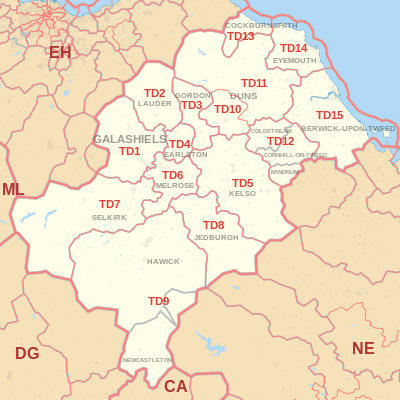
The approximate coverage of the postcode districts:
| Postcode district | Post town | Coverage | Local authority area |
|---|---|---|---|
| TD1 | GALASHIELS | Galashiels, Blainslie, Clovenfords, Fountainhall, Stow, Tweedbank | Scottish Borders Council |
| TD2 | LAUDER | Lauder, Oxton | Scottish Borders Council |
| TD3 | GORDON | Scottish Borders Council | |
| TD4 | EARLSTON | Scottish Borders Council | |
| TD5 | KELSO | Scottish Borders Council | |
| TD6 | MELROSE | Scottish Borders Council | |
| TD7 | SELKIRK | Scottish Borders Council | |
| TD8 | JEDBURGH | Jedburgh, Ancrum, Camptown, Crailing, Jed Valley, Nisbet, Oxnam | Scottish Borders Council |
| TD9 | HAWICK, NEWCASTLETON | Hawick, Newcastleton, Bedrule, Bonchester Bridge, Chesters, Denholm, Kershopefoot, Newmill-on-Teviot, Roberton, Wilton Dean | Scottish Borders Council, Carlisle City Council |
| TD10 | DUNS | Greenlaw | Scottish Borders Council |
| TD11 | DUNS | Duns | Scottish Borders Council |
| TD12 | COLDSTREAM, CORNHILL-ON-TWEED, MINDRUM | Scottish Borders Council, Northumberland County Council | |
| TD13 | COCKBURNSPATH | East Lothian Council, Scottish Borders Council | |
| TD14 | EYEMOUTH | Scottish Borders Council | |
| TD15 | BERWICK-UPON-TWEED | Holy Island | Northumberland County Council, Scottish Borders Council |
Map
See also
References
- ↑ "ONS Postcode Directory Version Notes" (ZIP). National Statistics Postcode Products. Office for National Statistics. February 2012. Table 2. Retrieved 21 April 2012. Coordinates from mean of unit postcode points, "Code-Point Open". OS OpenData. Ordnance Survey. February 2012. Retrieved 21 April 2012.
- ↑ Royal Mail, Address Management Guide, (2004)
External List
This article is issued from Wikipedia - version of the 4/14/2016. The text is available under the Creative Commons Attribution/Share Alike but additional terms may apply for the media files.