Lindisfarne
| Lindisfarne | |
| Holy Island | |
 Lindisfarne Castle |
|
 Lindisfarne |
|
| Population | 180 (27 March 2011)[1] |
|---|---|
| OS grid reference | NU129420 |
| Civil parish | Holy Island |
| Unitary authority | Northumberland |
| Region | North East |
| Country | England |
| Sovereign state | United Kingdom |
| Post town | BERWICK UPON TWEED |
| Postcode district | TD15 |
| Dialling code | 01289 |
| Police | Northumbria |
| Fire | Northumberland |
| Ambulance | North East |
| EU Parliament | North East England |
| UK Parliament | Berwick-upon-Tweed |
|
|
Coordinates: 55°40′09″N 1°47′05″W / 55.66905°N 1.78485°W
The Holy Island of Lindisfarne is a tidal island off the northeast coast of England. It is also known just as Holy Island.[2] It constitutes the civil parish of Holy Island in Northumberland.[3] Holy Island has a recorded history from the 6th century AD. It was an important centre of Celtic Christianity under Saints Aidan of Lindisfarne, Cuthbert, Eadfrith of Lindisfarne and Eadberht of Lindisfarne. After the Viking invasions and the Norman conquest of England, a priory was reestablished. A small castle was built on the island in 1550.
Toponymy
The island of Lindisfarne appears under the Old Welsh name Medcaut in the 9th century Historia Brittonum.[4] Following up on a suggestion by Richard Coates, Andrew Breeze proposes that the name ultimately derives from Latin Medicata [Insula] (English: Healing [Island]), owing perhaps to the island's reputation for medicinal herbs.[5]
Both the Parker Chronicle and Peterborough Chronicle annals of AD 793 record the Old English name, Lindisfarena.[6] The soubriquet Holy Island was in use by the 11th century when it appears in Latin as Insula Sacra. The reference was to saints Aidan and Cuthbert.[7]
The name Lindisfarne has an uncertain origin. The first part, Lindis, may refer to people from the Kingdom of Lindsey in modern Lincolnshire, referring to either regular visitors or settlers.[8][9][10] Alternatively the name may be Celtic in origin, with the element Lindis- meaning "stream or pool". It is not known if this is a reference to the nearby River Low or a small lake on the island. The second element probably comes from Farran meaning "land", but may come from Faran, a traveller. There is also a supposition that the nearby Farne Islands are fern like in shape and the name may have come from there.[7]
Geography and population
.jpg)
The island measures 3 miles (4.8 km) from east to west and 1.5 miles (2.4 km) from north to south, and comprises approximately 1,000 acres (400 ha) (4 km2) at high tide. The nearest point of the island is about 1 mile (1.6 km) from the mainland of England. The island of Lindisfarne is located along the northeast coast of England, close to the border with Scotland. It is accessible, most times, at low tide by crossing sand and mud flats which are covered with water at high tides. These sand and mud flats carry an ancient pilgrims' path, and in more recent times, a modern causeway. Lindisfarne is surrounded by the 8,750-acre Lindisfarne National Nature Reserve, which protects the island's sand dunes and the adjacent intertidal habitats. As of 27 March 2011 the island had a population of 180.[11]
Causeway safety
Warning signs urge visitors walking to the island to keep to the marked path, check tide times and weather carefully and to seek local advice if in doubt. For drivers, tide tables are prominently displayed at both ends of the causeway and also where the Holy Island road leaves the A1 Great North Road at Beal. The causeway is generally open from about three hours after high tide until two hours before the next high tide, but the period of closure may be extended during stormy weather. Tide tables giving the safe crossing periods are published by Northumberland County council.[12]
Despite these warnings, about one vehicle each month is stranded on the causeway, requiring rescue by HM Coastguard, Seahouses RNLI lifeboat, or RAF helicopter. A sea rescue costs approximately £1,900 (equivalent to £2,298 in 2015[lower-alpha 1]), while an air rescue costs more than £4,000 (equivalent to £4,839 in 2015[lower-alpha 1]).[13] Local people have opposed a causeway barrier primarily on convenience grounds.[14][13]
Lighthouses
 Guile Point Lighthouse | |
|
Northumberland | |
| Location |
Lindisfarne Northumberland England |
|---|---|
| Coordinates | 55°39′29″N 1°47′35″W / 55.658189°N 1.793194°W |
| Year first constructed | 1859 |
| Automated | yes |
| Construction | stone obelisk (east and west) |
| Tower shape | slim square pyramid tower (east and west) |
| Markings / pattern | unpainted tower |
| Height |
21 metres (69 ft) (east) 25 metres (82 ft) (west) |
| Focal height | 9 metres (30 ft) (east) |
| Light source | solar power |
| Range | 9 nautical miles (17 km; 10 mi) |
| Characteristic | Oc WRG 6s. (east) |
| Admiralty number | A2816 |
| NGA number | 2262 |
| ARLHS number | ENG-222 |
| Managing agent |
Trinity House[15] [16] |
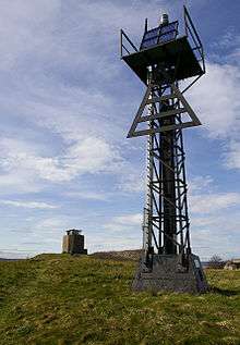 Heugh Hill Lighthouse in 2007 | |
| Location |
Lindisfarne Northumberland England |
|---|---|
| Coordinates | 55°40′06″N 1°47′58″W / 55.668224°N 1.799583°W |
| Automated | yes |
| Foundation | concrete basement |
| Construction | metal skeletal tower |
| Tower shape | square parallelepiped tower with balcony, red triangle and light |
| Markings / pattern | black tower |
| Height | 8 metres (26 ft) |
| Focal height | 24 metres (79 ft) |
| Light source | solar power |
| Range | 5 nautical miles (9.3 km; 5.8 mi) |
| Characteristic | Oc WRG 6s. |
| ARLHS number | ENG 314 |
| Managing agent | Trinity House [17] |
Trinity House operates two lighthouses to guide vessels entering Holy Island Harbour, named Guile Point East and Heugh Hill. The former is one of a pair of stone obelisks standing on a small tidal island on the other side of the channel. The obelisks are leading marks which, when aligned, indicate the safe channel over the bar. When Heugh Hill bears 310° (in line with the church belfry) the bar is cleared and there is a clear run into the harbour.[18] Since the early 1990s, a sector light has been fixed to it about one-third of the way up Guile Point East.[19] The latter is a metal framework tower with a black triangular day mark, situated on a ridge on the south edge of Lindisfarne. Prior to November 1995 both were owned/operated by Newcastle-upon-Tyne Trinity House.[20] Nearby is a former coastguard station (recently refurbished and opened to the public as a viewing platform). An adjacent ruin is known as the Lantern Chapel; its origin is unknown, but the name may indicate an earlier navigation light on this site.
Not a lighthouse but simply a daymark for maritime navigation, a white brick pyramid, 35 feet high and built in 1810, stands at Emmanuel Head, the north-eastern point of Lindisfarne. It is said to be Britain's earliest purpose-built daymark.[21]
|

History
Early
The northeast coast of England was largely unsettled by Roman civilians apart from the Tyne valley and Hadrian's Wall. The area had been little affected during the centuries of nominal Roman occupation. The countryside had been subject to raids from both Scots and Picts and was "not one to attract early Germanic settlement".[22] King Ida (reigned from 547) started the sea-borne settlement of the coast, establishing an urbs regia[lower-alpha 2] at Bamburgh across the bay from Lindisfarne. The conquest was not straightforward, however. The Historia Brittonum recounts how, in the 6th century, Urien, prince of Rheged, with a coalition of North British kingdoms, besieged Angles led by Theodric of Bernicia at the island for three days and nights, until internal power struggles led to the Britons' defeat.[23][24]
Lindisfarne Priory

The monastery of Lindisfarne was founded by Irish monk Saint Aidan, who had been sent from Iona off the west coast of Scotland to Northumbria at the request of King Oswald. The priory was founded before the end of 634 and Aidan remained there until his death in 651.[25] The priory remained the only seat of a bishopric in Northumbria for nearly thirty years.[25] Finian (bishop 651–661) built a timber church "suitable for a bishop's seat".[26] St. Bede however was critical of the fact that the church was not built of stone but only of hewn oak thatched with reeds. A later bishop, Eadbert removed the thatch and covered both walls and roof in lead.[27] An abbot, who could be the bishop, was elected by the brethren and led the community. St. Bede comments on this:
And let no one be surprised that, though we have said above that in this island of Lindisfarne, small as it is, there is found the seat of a bishop, now we say also that it is the home of an abbot and monks; for it actually is so. For one and the same dwelling-place of the servants of God holds both; and indeed all are monks. Aidan, who was the first bishop of this place, was a monk and always lived according to monastic rule together with all his followers. Hence all the bishops of that place up to the present time exercise their episcopal functions in such a way that the abbot, who they themselves have chosen by the advice of the brethren, rules the monastery; and all the priests, deacons, singers and readers and other ecclesiastical grades, together with the bishop himself, keep the monastic rule in all things.[28]
Lindisfarne became the base for Christian evangelism in the North of England and also sent a successful mission to Mercia. Monks from the Irish community of Iona settled on the island. Northumberland's patron saint, Saint Cuthbert, was a monk and later abbot of the monastery, and his miracles and life are recorded by the Venerable Bede. Cuthbert later became Bishop of Lindisfarne. An anonymous life of Cuthbert written at Lindisfarne is the oldest extant piece of English historical writing. From its reference to "Aldfrith, who now reigns peacefully" it must date to between 685 and 704.[29] Cuthbert was buried here, his remains later translated[lower-alpha 3] to Durham Cathedral (along with the relics of Saint Eadfrith of Lindisfarne). Eadberht of Lindisfarne, the next bishop (and saint) was buried in the place from which Cuthbert's body was exhumed earlier the same year when the priory was abandoned in the late 9th century.

Cuthbert's body was carried with the monks, eventually settling in Chester-le-Street before a final move to Durham. The saint's shrine was the major pilgrimage centre for much of the region until its despoliation by Henry VIII's commissioners in 1539 or 1540. The grave was preserved however and when opened in 1827 yielded a number of remarkable artefacts dating back to Lindisfarne. The inner (of three) coffins was of incised wood, the only decorated wood to survive from the period. It shows Jesus surrounded by the Four Evangelists. Within the coffin was a pectoral cross 6.4 centimetres (2.5 in) across made of gold and mounted with garnets and intricate tracery. There was a comb made of elephant ivory, a rare and expensive item in Northern England. Also inside was an embossed silver covered travelling altar. All were contemporary with the original burial on the island. When the body was placed in the shrine in 1104 other items were removed: a paten, scissors and a chalice of gold and onyx. Most remarkable of all was a gospel (known as the St Cuthbert Gospel or Stonyhurst Gospel from its association with the college). The manuscript is in an early, probably original, binding beautifully decorated with deeply embossed leather.[30]
Following Finian's death, Colman became Bishop of Lindisfarne. Up to this point the Northumbrian (and latterly Mercian) churches had looked to Lindisfarne as the mother church. There were significant liturgical and theological differences with the fledgling Roman party based at Canterbury. According to Stenton: "There is no trace of any intercourse between these bishops [the Mercians] and the see of Canterbury".[31] The Synod of Whitby in 663 changed this. Allegiance switched southwards to Canterbury and thence to Rome. Colman departed his see for Iona and Lindisfarne ceased to be of such major importance.
In 735 the northern ecclesiastical province of England was established with the archbishopric at York. There were only three bishops under York: Hexham, Lindisfarne and Whithorn whereas Canterbury had the twelve envisaged by St. Augustine.[32] The Diocese of York encompassed roughly the counties of Yorkshire and Lancashire. Hexham covered County Durham and the southern part of Northumberland up to the River Coquet and eastwards into the Pennines. Whithorn covered most of Dumfries and Galloway region west of Dumfries itself. The remainder, Cumbria, northern Northumbria, Lothian and much of the Kingdom of Strathclyde formed the diocese of Lindisfarne.[33]
For long years David Adam was rector of Holy Island and ministered to thousands of pilgrims and other visitors.
Lindisfarne Gospels
At some point in the early 8th century, the famous illuminated manuscript known as the Lindisfarne Gospels, an illustrated Latin copy of the Gospels of Matthew, Mark, Luke and John, was made probably at Lindisfarne and the artist was possibly Eadfrith, who later became Bishop of Lindisfarne. Sometime in the second half of the 10th century a monk named Aldred added an Anglo-Saxon (Old English) gloss to the Latin text, producing the earliest surviving Old English copies of the Gospels. Aldred attributed the original to Eadfrith (bishop 698–721). The Gospels were written with a good hand, but it is the illustrations done in an insular style containing a fusion of Celtic, Germanic and Roman elements that are truly outstanding. According to Aldred, Eadfrith's successor Æthelwald was responsible for pressing and binding it and then it was covered with a fine metal case made by a hermit called Billfrith.[31] The Lindisfarne Gospels now reside in the British Library in London, somewhat to the annoyance of some Northumbrians.[34] In 1971 professor Suzanne Kaufman of Rockford, Illinois presented a facsimile copy of the Gospels to the clergy of the island.
Vikings

In 793, a Viking raid on Lindisfarne[35][lower-alpha 4] caused much consternation throughout the Christian west and is now often taken as the beginning of the Viking Age. The D and E versions of the Anglo-Saxon Chronicle record:
Her wæron reðe forebecna cumene ofer Norðhymbra land, ⁊ þæt folc earmlic bregdon, þæt wæron ormete þodenas ⁊ ligrescas, ⁊ fyrenne dracan wæron gesewene on þam lifte fleogende. Þam tacnum sona fyligde mycel hunger, ⁊ litel æfter þam, þæs ilcan geares on .vi. Idus Ianuarii, earmlice hæþenra manna hergunc adilegode Godes cyrican in Lindisfarnaee þurh hreaflac ⁊ mansliht.[39]
In this year fierce, foreboding omens came over the land of the Northumbrians, and the wretched people shook; there were excessive whirlwinds, lightning, and fiery dragons were seen flying in the sky. These signs were followed by great famine, and a little after those, that same year on 6th ides of January, the ravaging of wretched heathen people destroyed God's church at Lindisfarne.
The generally accepted date for the Viking raid on Lindisfarne is in fact 8 June; Michael Swanton writes: "vi id Ianr, presumably [is] an error for vi id Iun (8 June) which is the date given by the Annals of Lindisfarne (p. 505), when better sailing weather would favour coastal raids."[40][lower-alpha 5]
Alcuin, a Northumbrian scholar in Charlemagne's court at the time, wrote:
Never before has such terror appeared in Britain as we have now suffered from a pagan race ... The heathens poured out the blood of saints around the altar, and trampled on the bodies of saints in the temple of God, like dung in the streets.[41]
The English seemed to have turned their back on the sea as they became more settled. Many monasteries were established on islands, peninsulas, river mouths and cliffs. Isolated communities were less susceptible to interference and the politics of the heartland. The amazement of the English at the raids from the sea must have been matched by the amazement of the raiders at such (to them) vulnerable, wealthy and unarmed settlements.[42]
These preliminary raids, unsettling as they were, were not followed up. The main body of the raiders passed north around Scotland.[43] The 9th century invasions came not from Norway, but by the Danes from around the entrance to the Baltic.[43] The first Danish raids into England were in the Isle of Sheppey, Kent during 835 and from there influence spread north.[44] During this period religious art continued to flourish on Lindisfarne, at this period the Liber Vitae of Durham was started in the priory.[45]
By 866 the Danes were in York and in 873 the army was moving into Northumberland.[46] With the collapse of the Northumbrian kingdom the monks of Lindisfarne fled the island in 875 taking with them St. Cuthbert's bones (which are now buried at the cathedral in Durham).[47]
Prior to the 9th century Lindisfarne Priory had, in common with other such establishments, held large tracts of land which were managed directly or leased to farmers with a life interest only. Following the Danish occupation land was increasingly owned by individuals and could be bought, sold and inherited. Following the Battle of Corbridge in 914 Ragnald seized the land giving some to his followers Scula and Onlafbal.[48]
Middle Ages
The priory was re-established in Norman times in 1093 as a Benedictine house and continued until its suppression in 1536 under Henry VIII. The standing remains date from this later priory, while the site of the original priory is now occupied by the parish church. The site is a grade I listed building number 1042304.[49] The earliest parts of the area are a scheduled ancient monument number 1011650.[50]
In 1462, during the Wars of the Roses, Margaret of Anjou made an abortive attempt to seize the Northumbrian castles. Following a storm at sea 400 troops had to seek shelter on the Holy Island, where they surrendered to the Yorkists.[51]
During the Jacobite Rising of 1715, Lancelot Errington, one of a number of locals who supported the Jacobite cause, visited the castle. Some sources say that Lancelot asked the Master Gunner, who also served as the unit's barber for a shave.[52] While inside it became clear that most of the garrison were away. Later that day he returned with his nephew Mark Errington, claiming that he had lost the key to his watch.[52] They were allowed in, overpowered the three soldiers present, and claimed the castle as a landing site for the Jacobite group led by Thomas Forster, Member of Parliament for the county of Northumberland.[53] Reinforcements did not arrive to support the Erringtons, so when a detachment of 100 men arrived from Berwick to retake the castle they were only able to hold out for one day. Fleeing, they were captured at the tollbooth at Berwick and imprisoned, but were later able to tunnel out of their gaol and escape.[52]
Modern
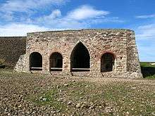
A Dundee firm built lime kilns on Lindisfarne in the 1860s, and lime was burnt on the island until at least the end of the 19th century. The kilns are among the most complex in Northumberland. Horses carried limestone, along the Holy Island Waggonway, from a quarry on the north side of the island to the lime kilns, where it was burned with coal transported from Dundee on the east coast of Scotland. There are still some traces of the jetties by which the coal was imported and the lime exported close by at the foot of the crags. The remains of the waggon way between the quarries and the kilns makes for a pleasant and easy walk. At its peak over 100 men were employed. Crinoid columnals extracted from the quarried stone and threaded into necklaces or rosaries became known as St Cuthbert's beads.
Workings on the lime kilns stopped by the start of the 20th century.[54] The lime kilns on Lindisfarne are among the few being actively preserved in Northumberland.[54]
Holy Island Golf Club was founded in 1907 but later closed in the 1960s.[55]
Present day

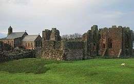


The island is within an Area of Outstanding Natural Beauty on the Northumberland Coast. The ruined monastery is in the care of English Heritage, which also runs a museum/visitor centre nearby. The neighbouring parish church (see below) is still in use.
Lindisfarne also has the small Lindisfarne Castle, based on a Tudor fort, which was refurbished in the Arts and Crafts style by Sir Edwin Lutyens for the editor of Country Life, Edward Hudson. Lutyens also designed the island's Celtic-cross war-memorial on the Heugh. Lutyens' upturned herring buses near the foreshore provided the inspiration for Spanish architect Enric Miralles' Scottish Parliament Building in Edinburgh.[56]
One of the most celebrated gardeners of modern times, Gertrude Jekyll (1843–1932), laid out a tiny garden just north of the castle in 1911.[57] The castle, garden and nearby lime kilns are in the care of the National Trust and open to visitors.[57]
Turner, Thomas Girtin and Charles Rennie Mackintosh all painted on Holy Island.
Holy Island was considered part of the Islandshire unit along with several mainland parishes. This came under the jurisdiction of the County Palatine of Durham until the Counties (Detached Parts) Act 1844.
Lindisfarne was mainly a fishing community for many years, with farming and the production of lime also of some importance.
The Holy Island of Lindisfarne is well known for mead. In the mediaeval days when monks inhabited the island, it was thought that if the soul was in God's keeping, the body must be fortified with Lindisfarne mead. The monks have long vanished, and the mead's recipe remains a secret of the family which still produces it; Lindisfarne Mead is produced at St Aidan's Winery, and sold throughout the UK and elsewhere.
The isle of Lindisfarne was featured on the television programme Seven Natural Wonders as one of the wonders of the North. The Lindisfarne Gospels have also featured on television among the top few Treasures of Britain. It also features in an ITV Tyne Tees programme Diary of an Island which started on 19 April 2007 and on a DVD of the same name.

St Mary the Virgin
When the abbey was rebuilt by the Normans, the site was moved. The site of the original priory church was redeveloped in stone as the parish church. As such it is now the oldest building on the island still with a roof on. Remains of the Saxon church exist as the chancel wall and arch. A Norman apse (subsequently replaced in the 13th century) led eastwards from the chancel. The nave was extended in the 12th century with a northern arcade, and in the following century with a southern arcade.
After the Reformation the church slipped into disrepair until the restoration of 1860. The church is built of coloured sandstone which has had the Victorian plaster removed from it. The north aisle is known as the "fishermen's aisle" and houses the altar of St. Peter. The south aisle used to hold the altar of St. Margeret of Scotland, but now houses the organ.[58]
The church is a Grade I listed building number 1042304, listed as part of the whole priory.[49] The church forms most of the earliest part of the site and is a scheduled ancient monument number 1011650.[50]
Community Trust Fund / Holy Island Partnership
In response to the perceived lack of affordable housing on the isle of Lindisfarne, a group of islanders established a charitable foundation known as the 'Holy Island of Lindisfarne Community Development Trust' in 1996. They built a visitor centre on the island using the profits from sales. In addition, eleven community houses which are rented out to community members who want to continue to stay on the island were built. The trust is also responsible for management of the inner harbour. The Holy Island Partnership was formed in 2009 by members of the community as well as organisations and groups operating on the island.
Tourism

Tourism grew steadily throughout the 20th century, and the isle of Lindisfarne is now a popular destination for visitors to the area. Those tourists staying on the island while it is cut off by the tide experience the island in a much quieter state, as most day trippers leave before the tide rises. At low tide it is possible to walk across the sands following an ancient route known as Pilgrims' Way, but see the note above. This route is marked with posts and has refuge boxes for stranded walkers, just as the road has a refuge box for those who have left their crossing too late. The isle of Lindisfarne is surrounded by the 8,750-acre Lindisfarne National Nature Reserve which attracts bird-watchers to the tidal island.
In popular culture
Poetry
Sir Walter Scott wrote of the path from the island to the mainland, which is flooded twice a day by tides:
- For with the flow and ebb, its style
- Varies from continent to isle;
- Dry shod o'er sands, twice every day,
- The pilgrims to the shrine find way;
- Twice every day the waves efface
- Of staves and sandalled feet the trace.
Tony Harrison wrote of the famous gospels of Lindisfarne in his poem Initial Illumination[59] which begins:
- Farne cormorants with catches in their beaks
- shower fishscale confetti on the shining sea.
- The first bright weather here for many weeks
- for my Sunday G-day train bound for Dundee,
- off to St Andrew’s to record a reading,
- doubtful, in these dark days, what poems can do,
- and watching the mists round Lindisfarne receding
- my doubt extends to Dark Age Good Book too.
In film
- Lindisfarne (particularly the castle) is the setting of the Roman Polanski film Cul-de-Sac (1966) with Donald Pleasence and Lionel Stander, shot entirely on location there. The island is semi-fictionalised into "Lindisfarne Island" and the castle is "Rob Roy". There is no village. The tide rises round a car which is stuck on the causeway; also featured are the characteristic sheds made from local fishing boats, inverted and cut in half. These may still be seen on the island.
In print
- Lindisfarne is the setting for the mystery novel Holy Island: A DCI Ryan Mystery (2015) by LJ Ross.
- The sack of Lindisfarne monastery by a fleet of opportunistic Vikings is a pivotal event in Charles Barnitz's historical fantasy/adventure, The Deepest Sea (1995).[60]
- Lindisfarne plays a key role in Conqueror (2007), the second book of the Time's Tapestry series by Stephen Baxter.
- The monastery and monks of Lindisfarne are an important part of British author/broadcaster Melvyn Bragg's epic, historically based novel Credo (1996).
- Lindisfarne plays an important role in The Consciousness Plague (2002) by Paul Levinson, the 2nd novel in the Phil D'Amato series.
- Lindisfarena plays an important role in Bernard Cornwell's Saxon Tales series (2004–).
- A two-part story in DC Comics' Vertigo series Northlanders, for instance, concerns the destruction on the monastery.
- Lindisfarne is referred to as the Holy Isle in Nancy Farmer's book The Sea of Trolls (2004), which also references the Norse invasion of Lindisfarne.
- Lindesfarne is part of a quest given to Geirolf Ericsson, by his father, in the book The Last Viking (2011) by Sandra Hill.[61]
- Department 19 (2011), a fiction book by Will Hill, concludes on Lindisfarne.[62]
- The novel Dragon Under the Hill (1972), by former newsreader Gordon Honeycombe, is set on Holy Island.
- A thinly disguised version of Lindisfarne is the setting for the Lyndesfarne Bridge quartet of modern fantasy novels by Trevor Hopkins.
- The Quiet Isle, a location in the fictional series "A Song of Ice and Fire" by George R. R. Martin, has many traits resembling Lindisfarne, including tidal based access and a monastic community.
- Lindisfarne and Holy Island were used in J.P. Moore's novel Toothless (2010) as a staging area by the Knights Templar for an attack against the Black Yew.[63]
- Lindisfarne is known as Holy Island and the New Beginning in Brother in the Land (1984) by Robert Swindells.
- Wells Tower's short story, "Everything Ravaged, Everything Burned" (2009), is centred around a Viking raid on Lindisfarne.
- Lindisfarne is where the main character of Harry goes to on pilgrimage in the book The Kingdom by the Sea (1990) by Robert Westall. St. Cuthbert, Lindisfarne, and the Viking raid are also focal points of Westall's The Wind Eye.
- The events in "Witch: The Road to Lindisfarne" (2012), a role-playing game by Kevin Barthaud and Richard Lacy, take place during a two-week journey from London to Lindisfarne.
- In The Last Church, a Warhammer 40,000 short story by Graham McNeill, Lindisfarne is the site of the last practising Christian church on Earth until it is destroyed by The Emperor.
- The Tale of Castle Cottage (2011), the last of mystery writer Susan Wittig Albert's "Cottage Tales of Beatrix Potter," deals with the finding of an illuminated edition of the Biblical Book of Revelation, a fictitious, unfinished addendum to the Lindisfarne Gospels that was lost from the Cotton library before being transferred to the British Museum.
- Lindisfarne is the important setting for the Devil's Garden (2013) - 7th book of the Kirov saga by John Schettler.
In music
Aspects of the history and legends concerning Lindisfarne and the monastery have featured in the lyrics and concepts of bands, musicians and composers.
- The 40-part choral motet Love You Big as the Sky by British composer Peter McGarr, commissioned for the Tallis Festival 2007 and subtitled "a Lindisfarne Love Song", includes poems about Lindisfarne and the detailed geography of the area, including ship wrecks and lighthouses.
- The English folk/rock band Lindisfarne (1969–2003) was named after the island.
- The carriage of the remains of St Cuthbert from Lindisfarne to Durham is the subject of "The Road from Lindisfarne", the third movement of the Durham Concerto (2007) by Jon Lord.
- A theme which has been especially popular with metal bands of different genres and styles is the Viking invasion of AD 793. These range from heavy metal or power metal bands like Stormwarrior, Svartsot and Rebellion to more extreme bands such as Amon Amarth, Enslaved, Ancient Rites and Behemoth.
- Singer-songwriter James Blake included a two-part suite about Lindisfarne on his self-titled debut album (2011).
- Singer-songwriter Andrew White included two tracks, Holy Island and Lindisfarne Lullaby, on his CD Traces of Silver (2007).
- The Group Iona include the track Lindisfarne on their album Journey into Morn (1996)
- Norway's Verbum Press has published Sanger fra Lindisfarne (Songs from Liindisfarne) (2009). These are translations from The Celtic Hymnbook or the CD Songs from Lindisfarne published by Kevin Mayhew Publishers.
- Swedish viking metal band Thyrfing utilised Alcuin's quote "never before has such terror appeared [in Britain] as we have now suffered from a pagan race" in their song "Sweoland Conqueror", which appears on their third album Urkraft.
In television
- Freddie Frobisher, the flatulent hermit of Lindisfarne, is featured in Blackadder the second, episode Beer.
- The final episode of the second series of the TV series Cold Feet was filmed in Lindisfarne Castle.[64]
- Lindisfarne appears in the second episode of Robson Green's Wild Swimming Adventure, a 2009 UK TV programme. Robson Green manages to swim from the mainland to Lindisfarne Castle.
- In the second episode of Vikings ("Wrath of the Northmen"), the semi-legendary Ragnar Lodbrok organises and leads the 793 attack on the priory by a small band of Vikings who head west, arrive on the shores of Lindisfarne, and shortly thereafter conduct the raid.
- Episode 5 of the first series of Wolfblood ("Occam's Razor") takes place on Lindisfarne Island.
- Lindisfarne provides the setting for episode 5, series 2 of the television serial 55 Degrees North (2004–2005).
In other uses
- In 1972, poet William Irwin Thompson named his Lindisfarne Association after the monastery on the island.
References
Footnotes
- 1 2 UK CPI inflation numbers based on data available from Gregory Clark (2016), "The Annual RPI and Average Earnings for Britain, 1209 to Present (New Series)" MeasuringWorth.
- ↑ urbs regia: "city of the king", a royal settlement
- ↑ That is disinterred, moved and reburied
- ↑ Lindisfarne, or Holy Island, is a small tidal island off the coast of Northumbria where a monastery had been established in 634. Its shelving beaches provided a supposedly perfect landing for the shallow-draft ships of the Viking raiders who fell upon its unsuspecting and virtually unprotected monks in the summer of 793. This bloody assault on a "place more venerable than all in Britain" was one of the first positively recorded Viking raids on the west. Lindisfarne was supposedly a good place to attack because people in the dark ages would send their valuables to Lindisfarne, similar to a bank, for safekeeping.[36] Viking longships, with their shallow drafts and good manoeuvrability under both sail and oar, allowed their crews to strike deep inland up Europe's major rivers.[37] The world of the Vikings consisted of a loose grouping of the Scandinavian homelands and new overseas colonies, linked by sea routes that reached across the Baltic and the North Sea, spanning even the Atlantic.[38]
- ↑ This may be confusing to modern readers. The 6 refers to the number of days BEFORE the Ides, not after. The day itself was included, and so vi id was 6 days before the ides, counting the ides as 1. In June the ides falls on the 13th of the month, so vi id Jun was actually 8 June. See Roman calendar for full details.
Citations
- ↑ "Holy Island Ward population 2011". Retrieved 30 June 2015.
- ↑ Holy Island webmaster 2013.
- ↑ Northumberland County Council 2013.
- ↑ Nennius 1848, section 65.
- ↑ Breeze 2008, pp. 187–8.
- ↑ Freeborn, p. 39.
- 1 2 Simpson 2009.
- ↑ Mills 1997, p. 221.
- ↑ Myers 1985, p. 175.
- ↑ Ekwall 1960, pp. 298–9.
- ↑ Office for National Statistics 2013.
- ↑ Northumberland County Council 2014.
- 1 2 Costello 2009.
- ↑ BBC 2011.
- ↑ Guile Point East The Lighthouse Directory. University of North Carolina at Chapel Hill. Retrieved May 1st, 2016
- ↑ Guile Point Lighthouse Trinity House. Retrieved May 1st, 2016
- ↑ Heugh Hill Lighthouse photographers-resource. Retrieved May 1st, 2016
- ↑ Fowler 1990, p. 22:137.
- ↑ Corporation of Trinity House 2014, Guile Point East.
- ↑ Corporation of Trinity House 2014, Heugh Hill.
- ↑ Jones 2014.
- ↑ Myers 1985, p. 198.
- ↑ Breeze 2008, p. 187-8.
- ↑ Myers 1985, p. 199.
- 1 2 Stenton 1987, p. 118.
- ↑ Stenton 1987, p. 119.
- ↑ Loyn 1962, p. 275 quoting Bede 1896, II, 16; III, 25
- ↑ Bede & c. 730 in Colgrave 1940, pp. 207–9 cited by Blair 1977, pp. 133–4
- ↑ Colgrave 1940, p. 104 cited by Stenton 1987, p. 88
- ↑ Campbell 1982, pp. 80–81.
- 1 2 Stenton 1987, p. 120.
- ↑ Stenton 1987, p. 109.
- ↑ Blair 1977, p. 145 (map).
- ↑ BBC 2008.
- ↑ Graham-Campbell & Wilson 2001, Salt-water bandits.
- ↑ Graham-Campbell & Wilson 2001, p. 21.
- ↑ Graham-Campbell & Wilson 2001, p. 22.
- ↑ Graham-Campbell & Wilson 2001, p. 10.
- ↑ Jebson 2007, entry for 793.
- ↑ Swanton, p. 57.
- ↑ Killeen 2012, p. 30.
- ↑ Blair 1977, p. 63.
- 1 2 Stenton 1987, p. 239.
- ↑ Stenton 1987, p. 243.
- ↑ Stenton 1987, p. 95.
- ↑ Stenton 1987, pp. 247–251.
- ↑ Stenton 1987, p. 332.
- ↑ Richards 1991, pp. 30–31.
- 1 2 Historic England (1042304).
- 1 2 Historic England (1011650).
- ↑ Jacob 1988, p. 533.
- 1 2 3 Hutson 2006.
- ↑ Müller & Barton 2009.
- 1 2 The National Trust.
- ↑ "Holy Island Golf Club", "Golf's Missing Links".
- ↑ BBC 2000.
- 1 2 The National Trust 2014.
- ↑ Brother Damian SSF 2009.
- ↑ "Initial Illumination | poetryarchive.org". poetryarchive.org. Retrieved 28 July 2016.
- ↑ Barnitz 1995 reviewed in Annis 2012
- ↑ Hill 2011a.
- ↑ Hill 2011b.
- ↑ Moore 2010.
- ↑ IMDb 2005.
Bibliography
- Annis (2012), "The Deepest Sea by Charles Barnitz", HistoricalNovels.info, retrieved 22 February 2014
- Aslet, Clive (1982), The Last Country Houses, London
- Baker, David (1975), Lutyena at Lindisfarne, Newscastle: unpublished B Arch thesis,
- Brereton, Sir William (1844) [1635], Notes on a Journey through Durham and Northumberland in the Year 1635, Newcastle
- Brown, Jane (1996), Lutyens and the Edwardians, London
- Barnitz, Charles (1 September 1995), The Deepest Sea, Roc, ISBN 0-451-45504-5
- BBC (19 June 2011), Holy Island tourists 'driving into North Sea', retrieved 11 August 2013
- BBC (20 March 2008), "Viz creator urges gospels return", BBC News Online, retrieved 4 August 2016
- BBC (3 July 2000), "Scots Parliament architect dies", BBC News, retrieved 22 February 2014
- Bede (1896) [written c.731], Plummer, C., ed., "Historia Ecclesiastica Gentis Anglorum", Venerabilis Baedae Opera Historica, Oxford
- Bede (c. 730), The life of Cuthbert
- Blair, Peter Hunter (1977) [first edition 1959], An Introduction to Anglo-Saxon England (2nd ed.), OUP, ISBN 0-521-29219-0
- Breeze, Andrew (2008). "Medcaut, the Brittonic name of Lindisfarne". Northern History. 42: 187–8. doi:10.1179/174587005x38507.
- Brother Damian SSF (2009), St Mary's Parish Church – A brief tour
- Campbell, James (1982), The Anglo-Saxons, Penguin Books, ISBN 978-0-14-014395-9
- Colgrave, B, ed. (1940), The two lives of St Cuthbert, Cambridge
- H.M Colvin, ed. (1982) [1485–1600], The History of the King's Works, vol. IV (part II), London
- Cornforth, John (1985), The Inspiration of the Past, Harmondsworth
- Corporation of Trinity House (2014), Lighthouses, retrieved 21 February 2014
- Costello, Paul (23 July 2009), Tidal tourists mystify islanders, BBC News, Newcastle, retrieved 11 August 2013
- Ekwall, Eilert (1960), Concise Oxford Dictionary of English Place-Names (4th ed.), OUP
- Festing, Sally (1991), Gertrude Jekyll, London
- Fowler, Jean, ed. (1990), Reed's Nautical Almanac 1990, New Malden, Surrey: Thomas Reed Publications Limited, ISBN 0-947637-36-2
- Freeborn, Dennis, From Old English to Standard English: A Course Book in Language Variation across Time (2nd ed.)
- Graham, Peter Anderson, Lindisfarne Castle
- Graham-Campbell, James; Wilson, David M. (2001), The Viking World (Google Books) (3rd ed.), London: Frances Lincoln Ltd, ISBN 0-7112-1800-5, retrieved 1 December 2008
- Hill, Sandra (26 July 2011), The Last Viking (Reissue ed.), Avon, ISBN 978-0-06-201905-9
- Hill, Will (31 March 2011), Department 19, Razorbill, ISBN 1-59514-406-4
- Historic England, "Lindisfarne Priory pre-Conquest monastery and post-Conquest Benedictine cell (1011650)", National Heritage List for England, retrieved 14 August 2013
- Historic England, "Lindisfarne Priory (1042304)", National Heritage List for England, retrieved 14 August 2013
- Holy Island webmaster (2013), The Holy Island of Lindisfarne, retrieved 11 August 2013
- Hutson, Jeremy (20 September 2006), The History of Tudhoe Village: Dissent and Rebellion in County Durham, Durham University, retrieved 2 December 2014
- IMDb (27 September 2005), Cold Feet: Season 2, Episode 6, retrieved 22 February 2014
- Jacob, E. F. (1988) [first published 1961], The Fifteenth Century, 1399–1485, The Oxford History of England, VI, OUP, ISBN 0-19-821714-5
- Jebson, Tony (6 August 2007), Manuscript D: Cotton Tiberius B.iv: The Anglo-Saxon Chronicle: An Electronic Edition, retrieved 12 August 2013
- Jones, Robin (2014), Lighthouses of the North East Coast, Wellington, Somerset: Halsgrove
- Killeen, Richard (2012), A Brief History of Ireland, Running Press
- Loyn, H.R. (1962), Anglo-Saxon England and the Norman Conquest, Longman, ISBN 0-582-48232-1
- Magnusson, Magnus (1984), Lindisfarne, The Cradle Island, Oriel Press, ISBN 0-85362-223-X
- Mills, A. D. (1997), Oxford Dictionary of English Place-Names (2nd ed.), OUP
- Moore, J P (19 October 2010), Toothless (1st ed.), Dragon Moon Press, ISBN 978-1-897492-18-5
- Müller, Andrew J.; Barton, Roy (2009), Lindisfarne Castle, retrieved 2 December 2014
- Myers, J. N. L. (1985), The English Settlements, The Oxford History of England, 1B, OUP, ISBN 0-19-821719-6
- The National Trust, Holy Island Lime Kilns (Plaque outside Lime Kilns), Lindisfarne
- The National Trust (18 February 2014), Lindisfarne Castle, retrieved 22 February 2014
- Nennius (1848) [written c.829], Giles, J. A., ed., Historia Brittonum, London: Henry G. Bohn, retrieved 11 August 2013, published in "Six Old English Chronicles"
- Northumberland County Council (2013), Parish and town councils, retrieved 11 August 2013
- Northumberland County Council (30 January 2014), "Holy Island Crossing Times – Lindisfarne", Northumberland Life, Northumberland County Council, retrieved 19 February 2014
- Office for National Statistics (30 January 2013), "Usual Resident Population, 2011 (KS101EW)", Neighbourhood Statistics, retrieved 21 February 2014
- Richards, Julian D. (1991), Viking Age England, English Heritage Book of ..., BCA, ISBN 978-0-7134-6519-8
- Simpson, David (2009), "Place-Name Meanings K to O", Roots of the Region, retrieved 11 August 2013
- Simpson, Ray (2013), A Holy Island Prayer Book: Prayers and Readings from Lindisfarne, UK: Canterbury Press, ISBN 978-1-85311-474-8
- Stenton, Sir Frank M. (1987) [first published 1943], Anglo-Saxon England, The Oxford History of England, II (3rd ed.), OUP, ISBN 0-19-821716-1
- Swanton, Michael (6 April 2000) [c.1000], The Anglo-Saxon Chronicle (New ed.), Phoenix Press;, ISBN 1-84212-003-4
External links
| Wikimedia Commons has media related to Lindisfarne. |
| Wikivoyage has a travel guide for Lindisfarne. |
- Lindisfarne Guide on VisitNorthumberland.com
- Holy Island Safe Crossing Times
- Lindisfarne Priory Opening Times
- Lindisfarne Priory - English Heritage
- Images of Lindisfarne Castle
- Lindisfarne Castle
- 'Hover & Hear' pronunciations in the traditional dialect of Lindisfarne, and compare side by side with other accents from the UK and around the World.
- An illustrated walk on Lindisfarne
- Detailed historical record for Lindisfarne Priory
- Teachers' resource pack: English Heritage
- A Report on the Holy Island of Lindisfarne
- Lindisfarne Mead