KT postcode area
Postcode district boundaries: Bing / Google
| Kingston upon Thames postcode area | |
|---|---|
 KT | |
| Postcode area | KT |
| Postcode area name | Kingston upon Thames |
| Post towns | 19 |
| Postcode districts | 24 |
| Postcode sectors | 92 |
| Postcodes (live) | 14,511 |
| Postcodes (total) | 21,417 |
| Statistics as at February 2012[1] | |
The KT postcode area, also known as the Kingston upon Thames postcode area,[2] is a group of 24 postcode districts in England which are subdivisions of 19 post towns. These postcode districts cover parts of southwestern Greater London and northern Surrey.
Mail for this area is sorted at the Jubilee Mail Centre in Hounslow. In Greater London the area covers most of the Royal Borough of Kingston upon Thames and small parts of the boroughs of Richmond upon Thames, Merton and Sutton, while in Surrey it covers virtually all of the borough of Elmbridge, most of the borough of Epsom and Ewell, the northwestern part of the borough of Reigate and Banstead, the northern part of the Mole Valley district, the northeastern parts of the boroughs of Guildford and Woking and the southern part of the borough of Runnymede, as well as a very small part of the borough of Spelthorne.
Coverage
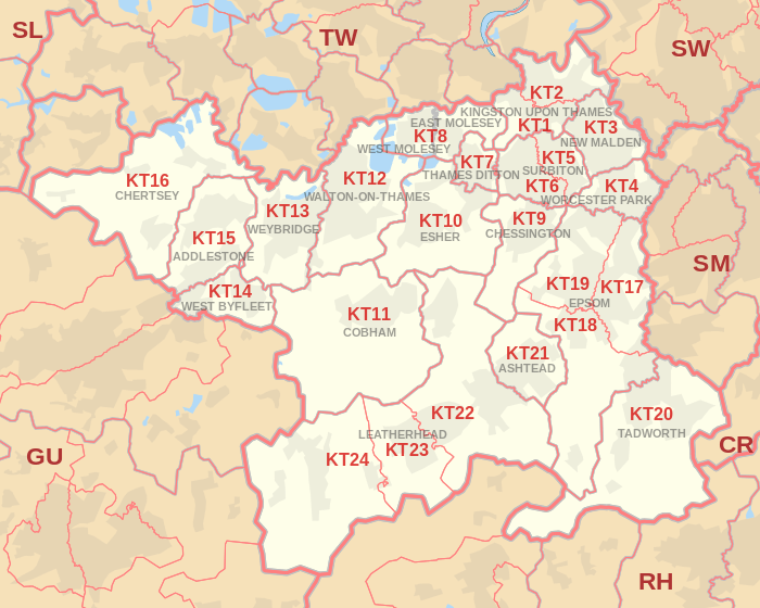
The approximate coverage of the postcode districts:
| Postcode district | Post town | Coverage | Local authority area |
|---|---|---|---|
| KT1 | KINGSTON UPON THAMES | Kingston upon Thames, Hampton Wick, Norbiton | Kingston upon Thames, Richmond upon Thames |
| KT2 | KINGSTON UPON THAMES | Kingston upon Thames, Canbury, Coombe | Kingston upon Thames, Richmond upon Thames |
| KT3 | NEW MALDEN | New Malden, part of Old Malden | Kingston upon Thames, Merton |
| KT4 | WORCESTER PARK | Worcester Park, Cuddington, part of Old Malden, Stoneleigh | Epsom and Ewell, Kingston upon Thames, Sutton |
| KT5 | SURBITON | Surbiton, Berrylands, Tolworth | Kingston upon Thames |
| KT6 | SURBITON | Surbiton, Tolworth, Long Ditton | Elmbridge, Kingston upon Thames |
| KT7 | THAMES DITTON | Thames Ditton, Weston Green | Elmbridge |
| KT8 | EAST MOLESEY & WEST MOLESEY | East Molesey, West Molesey, Hampton Court Palace and part of its Park; 1.5 Thames islands, part of Bushy Park, Hampton Court neighbourhood, Hampton | Elmbridge, Richmond upon Thames |
| KT9 | CHESSINGTON | Chessington including Malden Rushett, Hook, part of Long Ditton | Elmbridge, Kingston upon Thames |
| KT10 | ESHER | Esher, Claygate, Hinchley Wood | Elmbridge |
| KT11 | COBHAM | Cobham, Stoke d'Abernon, Downside, Hatchford, parts of Wisley, Ockham and Hersham | Elmbridge, Guildford, Mole Valley |
| KT12 | WALTON-ON-THAMES | Walton-on-Thames, Hersham, Whiteley Village | Elmbridge |
| KT13 | WEYBRIDGE | Weybridge, Oatlands, Saint George's Hill, Hamm Court | Elmbridge, Runnymede |
| KT14 | WEST BYFLEET | Byfleet, West Byfleet | Elmbridge, Runnymede, Woking |
| KT15 | ADDLESTONE | Addlestone, New Haw, Woodham | Runnymede, Woking |
| KT16 | CHERTSEY | Chertsey, Ottershaw, Longcross, Lyne, Dumsey Meadow in Littleton | Runnymede, Spelthorne |
| KT17 | EPSOM | Epsom, Ewell, Stoneleigh | Epsom and Ewell, Reigate and Banstead, Sutton |
| KT18 | EPSOM | Epsom, Tattenham Corner, Headley, Langley Vale | Epsom and Ewell, Mole Valley, Reigate and Banstead |
| KT19 | EPSOM | Epsom, West Ewell, Stoneleigh, Horton, Longmead | Epsom and Ewell |
| KT20 | TADWORTH | Tadworth, Kingswood, Lower Kingswood, Walton-on-the-Hill, Burgh Heath, Mogador, Box Hill | Mole Valley, Reigate and Banstead |
| KT21 | ASHTEAD | Ashtead | Mole Valley |
| KT22 | LEATHERHEAD | Leatherhead, Oxshott, Fetcham | Elmbridge, Mole Valley |
| KT23 | LEATHERHEAD | Great Bookham, Little Bookham | Guildford, Mole Valley |
| KT24 | LEATHERHEAD | West Horsley, East Horsley, Effingham | Guildford, Mole Valley |
Map
See also
References
- ↑ "ONS Postcode Directory Version Notes" (ZIP). National Statistics Postcode Products. Office for National Statistics. February 2012. Table 2. Retrieved 21 April 2012. Coordinates from mean of unit postcode points, "Code-Point Open". OS OpenData. Ordnance Survey. February 2012. Retrieved 21 April 2012.
- ↑ Royal Mail, Address Management Guide, (2004)