PH postcode area
Postcode district boundaries: Bing / Google
| Perth postcode area | |
|---|---|
 PH | |
| Postcode area | PH |
| Postcode area name | Perth |
| Post towns | 31 |
| Postcode districts | 43 |
| Postcode sectors | 61 |
| Postcodes (live) | 6,018 |
| Postcodes (total) | 7,114 |
| Statistics as at February 2012[1] | |
The PH postcode area, also known as the Perth postcode area,[2] is a group of postcode districts around Aberfeldy, Acharacle, Arisaig, Auchterarder, Aviemore, Ballachulish, Blairgowrie, Boat of Garten, Carrbridge, Corrour, Crieff, Dalwhinnie, Dunkeld, Fort Augustus, Fort William, Glenfinnan, Grantown-on-Spey, Invergarry, Isle of Canna, Isle of Eigg, Isle of Rum, Kingussie, Kinlochleven, Lochailort, Mallaig, Nethy Bridge, Newtonmore, Perth, Pitlochry, Roy Bridge and Spean Bridge in Scotland.
Coverage
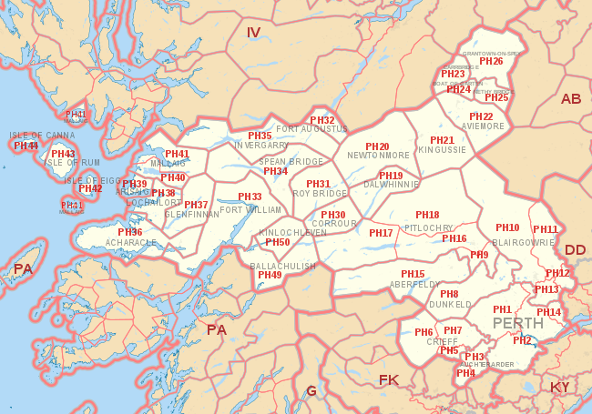
The approximate coverage of the postcode districts:
| Postcode district | Post town | Coverage | Local authority area |
|---|---|---|---|
| PH1 | PERTH | City centre north and west of the Post Office, and immediate hinterland villages | Perth and Kinross |
| PH2 | PERTH | City centre south and east of the Post Office, and immediate hinterland villages | Perth and Kinross |
| PH3 | AUCHTERARDER | Aberuthven | Perth and Kinross |
| PH4 | AUCHTERARDER | Blackford | Perth and Kinross |
| PH5 | CRIEFF | Muthill | Perth and Kinross |
| PH6 | CRIEFF | Comrie, St Fillans, Dunira | Perth and Kinross |
| PH7 | CRIEFF | Crieff, Gilmerton, Madderty | Perth and Kinross |
| PH8 | DUNKELD | Dunkeld, Birnam, Amulree | Perth and Kinross |
| PH9 | PITLOCHRY | Ballinuig, Strathy, Tulliemet | Perth and Kinross |
| PH10 | BLAIRGOWRIE | Blairgowrie and Rattray, Rattray, Bridge of Cally | Perth and Kinross |
| PH11 | BLAIRGOWRIE | Alyth | Perth and Kinross |
| PH12 | BLAIRGOWRIE | Meigle, Newtyle | Perth and Kinross, Angus |
| PH13 | BLAIRGOWRIE | Coupar Angus, | Perth and Kinross |
| PH14 | PERTH | Inchture, Abernyte | Perth and Kinross |
| PH15 | ABERFELDY | Aberfeldy | Perth and Kinross |
| PH16 | PITLOCHRY | Pitlochry, Strath Tummel, Kinloch Rannoch | Perth and Kinross |
| PH17 | PITLOCHRY | Rannoch, Bridge of Gaur | Perth and Kinross |
| PH18 | PITLOCHRY | Blair Atholl, Calvine, Bridge of Tilt | Perth and Kinross |
| PH19 | DALWHINNIE | Dalwhinnie | Highland |
| PH20 | NEWTONMORE | Newtonmore, Kinloch Laggan, Laggan | Highland |
| PH21 | KINGUSSIE | Kingussie, Insh, Kincraig | Highland |
| PH22 | AVIEMORE | Aviemore | Highland |
| PH23 | CARRBRIDGE | Carrbridge, Bogroy | Highland |
| PH24 | BOAT OF GARTEN | Boat of Garten | Highland |
| PH25 | NETHY BRIDGE | Nethy Bridge | Highland |
| PH26 | GRANTOWN-ON-SPEY | Grantown-on-Spey, Advie, Cromdale, Dulnain Bridge | Highland |
| PH30 | CORROUR | Corrour | Highland |
| PH31 | ROY BRIDGE | Roy Bridge, Murlaggan, Tulloch | Highland |
| PH32 | FORT AUGUSTUS | Fort Augustus, Auchterawe | Highland |
| PH33 | FORT WILLIAM | Fort William | Highland |
| PH34 | SPEAN BRIDGE | Spean Bridge, South Laggan, Achnacarry | Highland |
| PH35 | INVERGARRY | Invergarry | Highland |
| PH36 | ACHARACLE | Acharacle | Highland |
| PH37 | GLENFINNAN | Glenfinnan, Polloch | Highland |
| PH38 | LOCHAILORT | Lochailort, Glenuig, Kinlochmoidart | Highland |
| PH39 | ARISAIG | Arisaig | Highland |
| PH40 | MALLAIG | Morar | Highland |
| PH41 | MALLAIG | Mallaig, Knoydart | Highland |
| PH42 | ISLE OF EIGG | Isle of Eigg | Highland |
| PH43 | ISLE OF RUM | Isle of Rum | Highland |
| PH44 | ISLE OF CANNA | Isle of Canna | Highland |
| PH49 | BALLACHULISH | Ballachulish | Highland |
| PH50 | KINLOCHLEVEN | Kinlochleven | Highland |
Map
See also
- Postcode Address File
- List of postcode areas in the United Kingdom
- Centre points of the United Kingdom
- Extreme points of the United Kingdom
References
- ↑ "ONS Postcode Directory Version Notes" (ZIP). National Statistics Postcode Products. Office for National Statistics. February 2012. Table 2. Retrieved 21 April 2012. Coordinates from mean of unit postcode points, "Code-Point Open". OS OpenData. Ordnance Survey. February 2012. Retrieved 21 April 2012.
- ↑ Royal Mail, Address Management Guide, (2004)
External links
This article is issued from Wikipedia - version of the 10/11/2016. The text is available under the Creative Commons Attribution/Share Alike but additional terms may apply for the media files.