TS postcode area
Postcode district boundaries: Bing / Google
| Cleveland postcode area | |
|---|---|
 TS | |
| Postcode area | TS |
| Postcode area name | Cleveland |
| Post towns | 10 |
| Postcode districts | 30 |
| Postcode sectors | 103 |
| Postcodes (live) | 17,266 |
| Postcodes (total) | 22,112 |
| Statistics as at February 2012[1] | |
The TS postcode area, also known as the Cleveland postcode area,[2] (or unofficially as the Teesside postcode area) comprises the postcode districts covering the post towns of Billingham, Guisborough, Hartlepool, Middlesbrough, Redcar, Saltburn-by-the-Sea, Stockton-on-Tees, Trimdon Station, Wingate and Yarm in north east England. The postcode is centred on the town of Middlesbrough, with the TS1 postcode given to Central Middlesbrough and the residential areas immediately surrounding the town centre.
Coverage
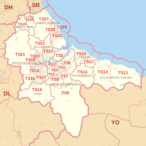
The approximate coverage of the postcode districts:
| Postcode district | Post town | Coverage | Local authority area |
|---|---|---|---|
| TS1 | MIDDLESBROUGH | Town Centre (Gresham, University, Abingdon,) | Middlesbrough |
| TS2 | MIDDLESBROUGH | Middlehaven, Port Clarence | Middlesbrough, Stockton-on-Tees |
| TS3 | MIDDLESBROUGH | Brambles Farm, Thorntree, Park End, North Ormesby, Berwick Hills | Middlesbrough |
| TS4 | MIDDLESBROUGH | Grove Hill, Longlands | Middlesbrough |
| TS5 | MIDDLESBROUGH | Acklam, Linthorpe | Middlesbrough |
| TS6 | MIDDLESBROUGH | Eston, Grangetown, Normanby, Teesville, South Bank | Redcar & Cleveland |
| TS7 | MIDDLESBROUGH | Marton, Nunthorpe, Ormesby | Middlesbrough, Redcar & Cleveland |
| TS8 | MIDDLESBROUGH | Coulby Newham, Marton, Hemlington Stainton, Thornton & Maltby | Middlesbrough, Stockton-on-Tees |
| TS9 | MIDDLESBROUGH | Great Ayton, Stokesley | Hambleton |
| TS10 | REDCAR | Redcar | Redcar & Cleveland |
| TS11 | REDCAR | Marske-by-the-Sea, New Marske | Redcar & Cleveland |
| TS12 | SALTBURN-BY-THE-SEA | Saltburn-by-the-Sea, Skelton-in-Cleveland, Brotton | Redcar & Cleveland |
| TS13 | SALTBURN-BY-THE-SEA | Loftus, Skinningrove, Staithes | Redcar & Cleveland, Scarborough |
| TS14 | GUISBOROUGH | Guisborough | Redcar & Cleveland |
| TS15 | YARM | Yarm, Kirklevington | Stockton-on-Tees |
| TS16 | STOCKTON-ON-TEES | Eaglescliffe, Egglescliffe, Aislaby | Stockton-on-Tees |
| TS17 | STOCKTON-ON-TEES | Thornaby, Ingleby Barwick, Stainton (part) | Stockton-on-Tees, Middlesbrough |
| TS18 | STOCKTON-ON-TEES | Central, Hartburn, Preston-on-Tees, Grangefield, Oxbridge, Portrack | Stockton-on-Tees |
| TS19 | STOCKTON-ON-TEES | Newtown, Fairfield, Hardwick, Roseworth, Bishopsgarth, Elm Tree Farm | Stockton-on-Tees |
| TS20 | STOCKTON-ON-TEES | Norton, Mount Pleasant | Stockton-on-Tees |
| TS21 | STOCKTON-ON-TEES | Stillington, Bishopton, Redmarshall, Thorpe Thewles, Carlton, Sedgefield, Long Newton | Stockton-on-Tees |
| TS22 | BILLINGHAM | Billingham (West), Wolviston | Stockton-on-Tees |
| TS23 | BILLINGHAM | Billingham (East) | Stockton-on-Tees |
| TS24 | HARTLEPOOL | Hartlepool Town Centre, Hartlepool Marina, Stranton, Belle Vue | Hartlepool |
| TS25 | HARTLEPOOL | Seaton Carew, Fens Estate, Owton Manor, Greatham | Hartlepool |
| TS26 | HARTLEPOOL | Middle Warren, Upper Warren, Bishop Cuthbert, Throston, West Park | Hartlepool |
| TS27 | HARTLEPOOL | Blackhall Rocks, Blackhall Colliery, Castle Eden, Hesleden, High Hesleden, Hutton Henry | Hartlepool, County Durham |
| TS28 | WINGATE | Wingate, Station Town | County Durham |
| TS29 | TRIMDON STATION | Trimdon | County Durham |
Map
See also
References
- ↑ "ONS Postcode Directory Version Notes" (ZIP). National Statistics Postcode Products. Office for National Statistics. February 2012. Table 2. Retrieved 21 April 2012. Coordinates from mean of unit postcode points, "Code-Point Open". OS OpenData. Ordnance Survey. February 2012. Retrieved 21 April 2012.
- ↑ Royal Mail, Address Management Guide, (2004)
External links
This article is issued from Wikipedia - version of the 6/1/2016. The text is available under the Creative Commons Attribution/Share Alike but additional terms may apply for the media files.