NG postcode area
Postcode district boundaries: Bing / Google
| Nottingham postcode area | |
|---|---|
 NG | |
| Postcode area | NG |
| Postcode area name | Nottingham |
| Post towns | 7 |
| Postcode districts | 32 |
| Postcode sectors | 167 |
| Postcodes (live) | 28,537 |
| Postcodes (total) | 35,779 |
| Statistics as at February 2012[1] | |
The NG postcode area, also known as the Nottingham postcode area,[2] is a group of postcode districts around Nottingham that covers Nottinghamshire (except for the Bassetlaw district and the far southwest of Rushcliffe borough), south east Derbyshire, south west Lincolnshire and part of north east Leicestershire.
Coverage
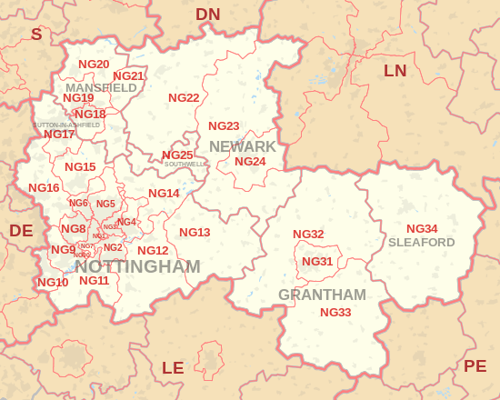
The approximate coverage of the postcode districts:
| Postcode district | Post town | Coverage | Local authority area |
|---|---|---|---|
| NG1 | NOTTINGHAM | Nottingham City Centre | Nottingham |
| NG2 | NOTTINGHAM | Nottingham City Centre, Colwick Park, Sneinton, The Meadows, West Bridgford | Nottingham, Rushcliffe , |
| NG3 | NOTTINGHAM | Carlton, Sneinton, St Ann's, Mapperley | Gedling, Nottingham |
| NG4 | NOTTINGHAM | Gedling Village, Netherfield | Gedling |
| NG5 | NOTTINGHAM | Sherwood, Arnold, Bestwood, Carrington, Top Valley, Rise Park | Nottingham, Gedling |
| NG6 | NOTTINGHAM | Bestwood Village, Bulwell, Old Basford | Nottingham, Gedling |
| NG7 | NOTTINGHAM | New Basford, Forest Fields, Hyson Green, Radford, Lenton | Nottingham |
| NG8 | NOTTINGHAM | Aspley, Wollaton, Whitemoor, Bilborough | Nottingham |
| NG9 | NOTTINGHAM | Beeston, Stapleford, Lenton Abbey, Chilwell, Trowell, Bramcote | Broxtowe, Nottingham |
| NG10 | NOTTINGHAM | Long Eaton, Sawley, Sandiacre | Erewash |
| NG11 | NOTTINGHAM | Clifton, Ruddington, Gotham, Kingston on Soar | Nottingham, Rushcliffe |
| NG12 | NOTTINGHAM | Cotgrave, Radcliffe on Trent, Keyworth, Edwalton | Rushcliffe |
| NG13 | NOTTINGHAM | Bingham, Whatton, Bottesford, Aslockton | Rushcliffe, Melton |
| NG14 | NOTTINGHAM | Calverton, Lowdham, Burton Joyce, Gunthorpe | Gedling |
| NG15 | NOTTINGHAM | Hucknall, Ravenshead, Newstead | Ashfield, Gedling |
| NG16 | NOTTINGHAM | Kimberley, Eastwood, Nuthall, Langley Mill, Pinxton, Selston, Awsworth, Ironville, Jacksdale, Westwood, Underwood, Brinsley, Watnall | Broxtowe, Amber Valley |
| NG17 | NOTTINGHAM, SUTTON-IN-ASHFIELD | Sutton-in-Ashfield, Kirkby-in-Ashfield, Stanton Hill, Skegby | Ashfield |
| NG18 | MANSFIELD | Mansfield | Mansfield |
| NG19 | MANSFIELD | Mansfield Woodhouse, Forest Town | Mansfield |
| NG20 | MANSFIELD | Shirebrook, Market Warsop | Bolsover |
| NG21 | MANSFIELD | Rainworth, Edwinstowe, Clipstone | Newark and Sherwood |
| NG22 | NEWARK | Bilsthorpe, Newark-on-Trent | Newark and Sherwood |
| NG23 | NEWARK | Newark-on-Trent, Collingham, Long Bennington | Newark and Sherwood |
| NG24 | NEWARK | Newark-on-Trent, Balderton | Newark and Sherwood |
| NG25 | SOUTHWELL | Southwell | Newark and Sherwood |
| NG31 | GRANTHAM | Grantham | South Kesteven |
| NG32 | GRANTHAM | Grantham, Croxton Kerrial, Sedgebrook | South Kesteven, Melton |
| NG33 | GRANTHAM | Grantham, Castle Bytham, Corby Glen | South Kesteven |
| NG34 | SLEAFORD | Sleaford, Scredington | North Kesteven |
| NG70 | MANSFIELD | Special Business Reply Service | Mansfield |
| NG80 | NOTTINGHAM | Experian | Nottingham |
| NG90 | NOTTINGHAM | Boots the Chemists | Broxtowe, Nottingham |
Map

Detailed map of postcode districts in central Nottingham
See also
References
- ↑ "ONS Postcode Directory Version Notes" (ZIP). National Statistics Postcode Products. Office for National Statistics. February 2012. Table 2. Retrieved 21 April 2012. Coordinates from mean of unit postcode points, "Code-Point Open". OS OpenData. Ordnance Survey. February 2012. Retrieved 21 April 2012.
- ↑ Royal Mail, Address Management Guide, (2004)
External links
This article is issued from Wikipedia - version of the 11/4/2016. The text is available under the Creative Commons Attribution/Share Alike but additional terms may apply for the media files.