BS postcode area
Postcode district boundaries: Bing / Google
| Bristol postcode area | |
|---|---|
 BS | |
| Postcode area | BS |
| Postcode area name | Bristol |
| Post towns | 8 |
| Postcode districts | 47 |
| Postcode sectors | 205 |
| Postcodes (live) | 26,550 |
| Postcodes (total) | 43,486 |
| Statistics as at February 2012[1] | |
The BS postcode area, also known as the Bristol postcode area,[2] is a group of postcode districts around Axbridge, Banwell, Bristol, Cheddar, Clevedon, Wedmore, Weston-super-Mare and Winscombe in England.
Coverage
The approximate coverage of the postcode districts:
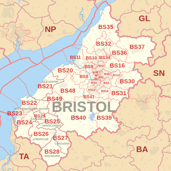
| Postcode district | Post town | Coverage | Local authority area |
|---|---|---|---|
| BS0 | BRISTOL | Non-geographic[3][4] | Bristol |
| BS1 | BRISTOL | Bristol city centre, Redcliffe | Bristol |
| BS2 | BRISTOL | Kingsdown, St Paul's, St Phillip's, St Agnes | Bristol |
| BS3 | BRISTOL | Bedminster, Southville, Bower Ashton, part of Totterdown, Windmill Hill | Bristol |
| BS4 | BRISTOL | Brislington, Knowle, Knowle West, St Anne's, part of Totterdown | Bristol |
| BS5 | BRISTOL | Easton, St George, Redfield, Whitehall, Eastville, Speedwell, Greenbank, Barton Hill | Bristol |
| BS6 | BRISTOL | Cotham, Redland, Montpelier, Westbury Park, St. Andrew's | Bristol |
| BS7 | BRISTOL | Bishopston, Horfield, part of Filton, Lockleaze, Ashley Down, | Bristol / South Gloucestershire |
| BS8 | BRISTOL | Clifton, Failand, Hotwells, Leigh Woods | Bristol / North Somerset |
| BS9 | BRISTOL | Coombe Dingle, Sneyd Park, Stoke Bishop, Westbury on Trym, Henleaze, Bristol | Bristol |
| BS10 | BRISTOL | Brentry, Henbury, Southmead part of Westbury on Trym, | Bristol |
| BS11 | BRISTOL | Avonmouth, Shirehampton, Lawrence Weston | Bristol |
| BS13 | BRISTOL | Bedminster Down, Bishopsworth, Hartcliffe, Withywood, Headley Park | Bristol |
| BS14 | BRISTOL | Hengrove, Stockwood, Whitchurch, Withywood | Bristol / Bath and North East Somerset |
| BS15 | BRISTOL | Hanham, Kingswood | Bristol / South Gloucestershire |
| BS16 | BRISTOL | Downend, Emersons Green, Fishponds, Frenchay, Staple Hill | Bristol / South Gloucestershire |
| BS20 | BRISTOL | Portishead | North Somerset |
| BS21 | CLEVEDON | Clevedon | North Somerset |
| BS22 | WESTON-SUPER-MARE | Kewstoke, Weston-super-Mare, Worle | North Somerset |
| BS23 | WESTON-SUPER-MARE | Uphill, Weston-super-Mare | North Somerset |
| BS24 | WESTON-SUPER-MARE | Bleadon, Hutton, Locking, Lympsham, Puxton, Weston-super-Mare, Wick St. Lawrence | North Somerset |
| BS25 | WINSCOMBE | Churchill, Winscombe, Sandford, Shipham | North Somerset, Somerset |
| BS26 | AXBRIDGE | Axbridge, Compton Bishop, Loxton | Somerset |
| BS27 | CHEDDAR | Cheddar, Draycott | Somerset |
| BS28 | WEDMORE | Wedmore | Somerset |
| BS29 | BANWELL | Banwell | Somerset |
| BS30 | BRISTOL | Bitton, Longwell Green, Cadbury Heath, Warmley, Wick | South Gloucestershire |
| BS31 | BRISTOL | Chewton Keynsham, Keynsham, Saltford | Bath and North East Somerset |
| BS32 | BRISTOL | Almondsbury, Bradley Stoke | South Gloucestershire |
| BS34 | BRISTOL | Part of Filton, Little Stoke, Patchway, Stoke Gifford | South Gloucestershire |
| BS35 | BRISTOL | Alveston, Rudgeway, Severn Beach, Pilning, Thornbury | South Gloucestershire |
| BS36 | BRISTOL | Frampton Cotterell, Winterbourne | South Gloucestershire |
| BS37 | BRISTOL | Chipping Sodbury, Yate | South Gloucestershire |
| BS39 | BRISTOL | Clutton, Temple Cloud | Bath and North East Somerset |
| BS40 | BRISTOL | Chew Valley, Chew Magna, Chew Stoke, Wrington | Bath and North East Somerset, North Somerset |
| BS41 | BRISTOL | Long Ashton, Dundry | North Somerset |
| BS48 | BRISTOL | Backwell, Nailsea | North Somerset |
| BS49 | BRISTOL | Congresbury, Yatton | North Somerset |
| BS98 | BRISTOL | Non-geographic | Bristol |
| BS99 | BRISTOL | Non-geographic | Bristol |
Historic codes
Until the 1990s (?date) different numbers were used for Bristol postcode districts from BS12 upwards.
Missing from the above list are: BS12, BS17, BS18 and BS19. Previously these were assigned as below.
BS12 covered: Almondsbury, Alveston, Aust, Awkley, Bradley Stoke, Earthcote Green, Easter Compton, Elberton, Filton, Ingst, Itchington, Littleton-on-Severn, Morton, Northwick, Oldbury Naite, Oldbury-on-Severn, Olveston, Over, Patchway, Pilning, Redwick, Rudgeway, Severn Beach, Shepperdine, Stoke Gifford, Thornbury, and Tockington
BS17 covered: Chipping Sodbury, Mangotsfield, Old Sodbury, Pucklechurch, Rangeworthy, Winterbourne, and Yate
BS18 covered: Compton Dando, High Littleton, Saltford, Long Ashton, West Harptree, Wrington, Chew Magna, Blagdon, and Temple Cloud, Keynsham.
BS19 covered: Backwell, Churchill, Congresbury, Flax Bourton, Nailsea and Yatton.
The above codes are correct, but not complete. Other towns and villages may have shared these postcodes.
Map

See also
References
- ↑ "ONS Postcode Directory Version Notes" (ZIP). National Statistics Postcode Products. Office for National Statistics. February 2012. Table 2. Retrieved 21 April 2012. Coordinates from mean of unit postcode points, "Code-Point Open". OS OpenData. Ordnance Survey. February 2012. Retrieved 21 April 2012.
- ↑ Royal Mail, Address Management Guide, (2004)
- ↑ "New sectors and localities to 18 May 2012" (PDF). Royal Mail Address Management Unit. 20 July 2012. Retrieved 18 August 2012.
- ↑ "Non Geographic Codes" (PDF). Royal Mail Address Management Unit. July 2012. Retrieved 18 August 2012.