HS postcode area
Postcode district boundaries: Bing / Google
| Outer Hebrides postcode area | |
|---|---|
 HS | |
| Postcode area | HS |
| Postcode area name | Outer Hebrides |
| Post towns | 8 |
| Postcode districts | 9 |
| Postcode sectors | 11 |
| Postcodes (live) | 953 |
| Postcodes (total) | 1,059 |
| Statistics as at February 2012[1] | |
The HS postcode area, also known as the Outer Hebrides postcode area,[2] is a group of postcode districts around Isle of Barra, Isle of Benbecula, Isle of Harris, Isle of Lewis, Isle of North Uist, Isle of Scalpay, Isle of South Uist and Stornoway in Scotland.
Coverage
The approximate coverage of the postcode districts:
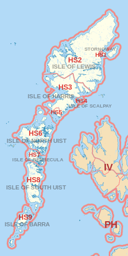
| Postcode district | Post town | Coverage | Local authority area |
|---|---|---|---|
| HS1 | STORNOWAY | Stornoway (immediate area), Plasterfield | Comhairle nan Eilean Siar |
| HS2 | STORNOWAY/ISLE OF LEWIS | Settlements outwith the Stornoway area including: Back, Carloway, Ness, North Lochs, Park (South Lochs), Point, Uig and West Side | Comhairle nan Eilean Siar |
| HS3 | ISLE OF HARRIS | Some settlements | Comhairle nan Eilean Siar |
| HS4 | ISLE OF SCALPAY | All settlements | Comhairle nan Eilean Siar |
| HS5 | ISLE OF HARRIS | Some settlements | Comhairle nan Eilean Siar |
| HS6 | ISLE OF NORTH UIST | All settlements | Comhairle nan Eilean Siar |
| HS7 | ISLE OF BENBECULA | All settlements | Comhairle nan Eilean Siar |
| HS8 | ISLE OF SOUTH UIST | All settlements | Comhairle nan Eilean Siar |
| HS9 | ISLE OF BARRA | All settlements | Comhairle nan Eilean Siar |
Map
See also
References
- ↑ "ONS Postcode Directory Version Notes" (ZIP). National Statistics Postcode Products. Office for National Statistics. February 2012. Table 2. Retrieved 21 April 2012. Coordinates from mean of unit postcode points, "Code-Point Open". OS OpenData. Ordnance Survey. February 2012. Retrieved 21 April 2012.
- ↑ Royal Mail, Address Management Guide, (2004)
External links
This article is issued from Wikipedia - version of the 8/24/2016. The text is available under the Creative Commons Attribution/Share Alike but additional terms may apply for the media files.