L postcode area
Postcode district boundaries: Bing / Google
| Liverpool postcode area | |
|---|---|
 L | |
| Postcode area | L |
| Postcode area name | Liverpool |
| Post towns | 4 |
| Postcode districts | 65 |
| Postcode sectors | 581 |
| Postcodes (live) | 20,322 |
| Postcodes (total) | 42,024 |
| Statistics as at February 2012[1] | |
The L postcode area, also known as the Liverpool postcode area,[2] is a group of postcode districts in Merseyside, Cheshire and Lancashire, specifically around Liverpool in England and including Bootle, Ormskirk and Prescot. In 1999, postcodes for the Wirral Peninsula (L41-49, 60-66) were transferred from L to the CH postcode area.[3]
Coverage
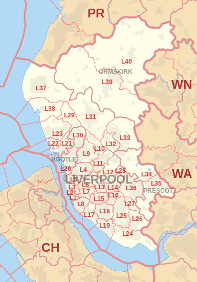
The approximate coverage of the postcode districts:
| Postcode district | Post town | Coverage | Local authority area |
|---|---|---|---|
| L1 | LIVERPOOL | City Centre | Liverpool |
| L2 | LIVERPOOL | City Centre | Liverpool |
| L3 | LIVERPOOL | City Centre, Everton, Vauxhall | Liverpool |
| L4 | LIVERPOOL | Anfield, Kirkdale, Walton | Liverpool |
| L5 | LIVERPOOL | Anfield, Everton, Kirkdale, Vauxhall | Liverpool |
| L6 | LIVERPOOL | Anfield, City Centre, Everton, Fairfield, Kensington, Tuebrook | Liverpool |
| L7 | LIVERPOOL | City Centre, Edge Hill, Fairfield, Kensington | Liverpool |
| L8 | LIVERPOOL | City Centre, Dingle, Toxteth | Liverpool |
| L9 | LIVERPOOL | Aintree, Fazakerley, Orrell Park, Walton | Liverpool, Sefton |
| L10 | LIVERPOOL | Aintree Village, Fazakerley | Sefton, Liverpool, Knowsley |
| L11 | LIVERPOOL | Clubmoor, Croxteth, Gillmoss, Norris Green | Liverpool |
| L12 | LIVERPOOL | Croxteth Park, West Derby | Liverpool |
| L13 | LIVERPOOL | Clubmoor, Old Swan, Stoneycroft, Tuebrook | Liverpool |
| L14 | LIVERPOOL | Broadgreen, Dovecot, Knotty Ash, Page Moss | Liverpool, Knowsley |
| L15 | LIVERPOOL | Wavertree | Liverpool |
| L16 | LIVERPOOL | Broadgreen, Bowring Park, Childwall | Liverpool, Knowsley |
| L17 | LIVERPOOL | Aigburth, St Michael's Hamlet, Sefton Park | Liverpool |
| L18 | LIVERPOOL | Allerton, Mossley Hill | Liverpool |
| L19 | LIVERPOOL | Aigburth, Garston, Grassendale, Mossley Hill | Liverpool |
| L20 | BOOTLE | Bootle, Orrell | Sefton, Liverpool |
| L20 | LIVERPOOL | Kirkdale | Liverpool |
| L21 | LIVERPOOL | Ford, Litherland, Seaforth | Sefton, Liverpool |
| L22 | LIVERPOOL | Waterloo | Sefton |
| L23 | LIVERPOOL | Blundellsands, Brighton-le-Sands, Crosby, Little Crosby, Thornton | Sefton |
| L24 | LIVERPOOL | Hale, Speke | Halton Liverpool |
| L25 | LIVERPOOL | Belle Vale, Gateacre, Hunts Cross, Woolton, Halewood | Liverpool, Knowsley |
| L26 | LIVERPOOL | Halewood | Liverpool, Knowsley |
| L27 | LIVERPOOL | Netherley | Liverpool |
| L28 | LIVERPOOL | Stockbridge Village | Liverpool, Knowsley |
| L29 | LIVERPOOL | Lunt, Sefton Village | Sefton |
| L30 | BOOTLE | Bootle, Netherton | Sefton |
| L31 | LIVERPOOL | Maghull, Lydiate, Melling, Waddicar | Sefton |
| L32 | LIVERPOOL | Kirkby | Knowsley |
| L33 | LIVERPOOL | Kirkby | Knowsley |
| L34 | PRESCOT | Prescot, Knowsley Village | Knowsley |
| L35 | PRESCOT | Prescot, Whiston, Rainhill | Knowsley, St Helens |
| L36 | LIVERPOOL | Huyton, Roby, Tarbock | Knowsley |
| L37 | LIVERPOOL | Formby, Little Altcar, Great Altcar | Sefton |
| L38 | LIVERPOOL | Ince Blundell, Hightown | Sefton |
| L39 | ORMSKIRK | Ormskirk, Aughton | West Lancashire |
| L40 | ORMSKIRK | Burscough, Mawdesley, Scarisbrick, Rufford, Holmeswood | West Lancashire, Chorley |
| L67 | LIVERPOOL | Littlewoods Pools[4] | non-geographic |
| L68 | LIVERPOOL | Vernons Pools[4] | non-geographic |
| L69 | LIVERPOOL | PO boxes in central Liverpool, government departments in Liverpool and Bootle, Liverpool University[4] | non-geographic |
| L70 | LIVERPOOL | seasonal response mail[4] | non-geographic |
| L71 | LIVERPOOL | American Express[4] | non-geographic |
| L72 | LIVERPOOL | Littlewoods[4] | non-geographic |
| L73 | LIVERPOOL | BT Group, large Selectapost users[4] | non-geographic |
| L74 | LIVERPOOL | HM Revenue and Customs (Customs and Excise)[4] | non-geographic |
| L75 | LIVERPOOL | HM Revenue and Customs (Inland Revenue)[4] | non-geographic |
| L80 | BOOTLE | non-geographic[5] |
Map
See also
References
- ↑ "ONS Postcode Directory Version Notes" (ZIP). National Statistics Postcode Products. Office for National Statistics. February 2012. Table 2. Retrieved 21 April 2012. Coordinates from mean of unit postcode points, "Code-Point Open". OS OpenData. Ordnance Survey. February 2012. Retrieved 21 April 2012.
- ↑ Royal Mail, Address Management Guide, (2004)
- ↑ "Why we are changing postcodes - Royal Mail". Wirral Globe. 18 March 1999. Archived from the original on 7 December 2008. Retrieved 7 December 2008.
- 1 2 3 4 5 6 7 8 9 "Non Geographic Codes" (PDF). Royal Mail Address Management Unit. July 2012. Retrieved 25 September 2012.
- ↑ "Postcode Update 54" (PDF). Royal Mail Address Management Unit. March 2012. Retrieved 25 September 2012.
External links
- Royal Mail's Postcode Address File
- A quick introduction to Royal Mail's Postcode Address File (PAF)
- Photographing Every Street in the Liverpool Postal Area
This article is issued from Wikipedia - version of the 11/7/2016. The text is available under the Creative Commons Attribution/Share Alike but additional terms may apply for the media files.