CO postcode area
Postcode district boundaries: Bing / Google
| Colchester postcode area | |
|---|---|
 CO | |
| Postcode area | CO |
| Postcode area name | Colchester |
| Post towns | 9 |
| Postcode districts | 16 |
| Postcode sectors | 74 |
| Postcodes (live) | 12,905 |
| Postcodes (total) | 17,146 |
| Statistics as at February 2012[1] | |
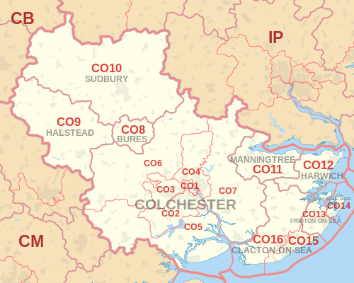
The CO postcode area, also known as the Colchester postcode area,[2] is a group of sixteen postcode districts in England, which are subdivisions of nine post towns. These postcode districts cover northeast Essex (including Colchester, Bures, Clacton-on-Sea, Frinton-on-Sea, Halstead, Harwich, Manningtree and Walton-on-the-Naze) and a small part of south Suffolk (including Sudbury). The main sorting office is in Colchester.
Coverage
The approximate coverage of the postcode districts:
| Postcode district | Post town | Coverage | Local authority area |
|---|---|---|---|
| CO1 | COLCHESTER | Colchester | Colchester |
| CO2 | COLCHESTER | Colchester, Old Heath, Berechurch, Layer de la Haye | Colchester |
| CO3 | COLCHESTER | Colchester, Lexden, Stanway | Colchester |
| CO4 | COLCHESTER | Colchester, Myland, Boxted | Colchester |
| CO5 | COLCHESTER | Tiptree, Kelvedon, West Mersea, Peldon, Rowhedge | Colchester, Braintree, Maldon |
| CO6 | COLCHESTER | Coggeshall, Earls Colne, Marks Tey, Great Tey, Chappel, Wakes Colne, Copford, West Bergholt, Great Horkesley, Wormingford, Nayland, Stoke-by-Nayland, Polstead | Colchester, Braintree, Babergh |
| CO7 | COLCHESTER | Brightlingsea, Wivenhoe, Great Bentley | Colchester, Tendring |
| CO8 | BURES | Bures, Alphamstone | Colchester, Braintree, Babergh |
| CO9 | HALSTEAD | Halstead | Braintree |
| CO10 | SUDBURY | Sudbury | Babergh |
| CO11 | MANNINGTREE | Manningtree, Lawford, Mistley, Bradfield, Wrabness, Wix, Horsley Cross, Little Bromley, Brantham, Cattawade | Tendring, Babergh |
| CO12 | HARWICH | Harwich, Dovercourt, Parkeston, Ramsey, Little Oakley, Great Oakley, Stones Green | Tendring |
| CO13 | FRINTON-ON-SEA | Frinton-on-Sea | Tendring |
| CO14 | WALTON ON THE NAZE | Walton-on-the-Naze[3] | Tendring |
| CO15 | CLACTON-ON-SEA | Clacton-on-Sea | Tendring |
| CO16 | CLACTON-ON-SEA | Clacton-on-Sea, St Osyth, Little Clacton | Tendring |
Map
See also
References
- ↑ "ONS Postcode Directory Version Notes" (ZIP). National Statistics Postcode Products. Office for National Statistics. February 2012. Table 2. Retrieved 21 April 2012. Coordinates from mean of unit postcode points, "Code-Point Open". OS OpenData. Ordnance Survey. February 2012. Retrieved 21 April 2012.
- ↑ Royal Mail, Address Management Guide, (2004)
- ↑ The post town is unhyphenated.
External links
This article is issued from Wikipedia - version of the 11/11/2016. The text is available under the Creative Commons Attribution/Share Alike but additional terms may apply for the media files.