Kemah, Texas
| City of Kemah | |
|---|---|
| City | |
|
Kemah Community Center | |
 Location of Kemah, Texas | |
| Coordinates: 29°32′33″N 95°1′13.08″W / 29.54250°N 95.0203000°WCoordinates: 29°32′33″N 95°1′13.08″W / 29.54250°N 95.0203000°W | |
| Country | United States |
| State | Texas |
| County | Galveston |
| Government | |
| • Mayor | Bob Cummins |
| Area | |
| • Total | 1.8 sq mi (4.7 km2) |
| • Land | 1.8 sq mi (4.6 km2) |
| • Water | 0.0 sq mi (0.1 km2) |
| Elevation | 7 ft (2 m) |
| Population | |
| • Total | 3,334 |
| • Density | 1,900/sq mi (710/km2) |
| Time zone | Central (CST) (UTC-6) |
| • Summer (DST) | CDT (UTC-5) |
| ZIP code | 77565 |
| Area code(s) | 281 |
| FIPS code | 48-38776[1] |
| GNIS feature ID | 1339021[2] |
| Website | www.kemah-tx.gov |

Kemah (/ˈkiːmə/ KEE-ma) is a city in the U.S. state of Texas, southeast of Houston along west Galveston Bay. The city's population is 3,334.[3] Located in Galveston County, Kemah's main industry is shipping. Originally a small fishing town, the city has become a tourist destination for the area's restaurants and attractions, which are contained within the Kemah Entertainment District. In fact, in 2012 Kemah was ranked the top tourism spot in the Greater Houston area.[4]
Geography

Kemah is located at 29°32′33″N 95°1′13.08″W / 29.54250°N 95.0203000°W (29.5425, -95.0203)[5] and is part of the Clear Lake Area.
According to the United States Census Bureau, the city has a total area of 1.82 square miles (4.7 km2), of which 1.79 square miles (4.6 km2) is land and 0.03 square miles (0.078 km2), or 1.65%, is water.
History
The land, measuring approximately 177 acres, was the basis for a town that would be called Kemah. This land was granted to one of the first colonists who was a farmer and stockraiser, Michael Gouldrich, on August 24, 1824.[6] Gouldrich’s land was located near Clear Creek and Galveston Bay.
However, after Gouldrich disappeared, William Vince from Harris County acquired Gouldrich’s Clear Creek land. Afterwards John Flanders, an Alamo fighter who was not supposed to have taken any land, bought the property from William Vince and it was renamed “Flanders Grove” or “Flanders Labor”. When Flanders died at the age of 36, Allen Vince, of Vince’s Bayou, was appointed executor of Flanders’ estate in 1841. On May 28, 1844, there was a petition to sell the land to pay off debts. Soon after, the land was appraised for $2 an acre and sold to Jonathan D. Waters. He bought the Clear Creek land on July 2, 1844, for $354.
After October 1850, Waters sold ten acres of the Clear Creek property to various people, but Henry Kipp eventually owned the land. During the 1890s, the Bradford and Kipp families moved to the area and portioned off the land into town lots in 1898, thus establishing the town known as Evergreen. It was located along the Texas and New Orleans Railroad, and the area was also called Shell Siding for the oyster shell middens lining the bay, in some places 20 to 30 feet (6.1 to 9.1 m) deep.
After the 1900 Galveston hurricane, the majority of the towns around Galveston Bay were destroyed, the Kipp and Bradford families were forced to evacuate but later move back to Evergreen in 1901. They rebuilt and restored the town, making two-story homes with porches for themselves on 10th street . In order for there to be a post office in the town, the name had to be changed because there was already a town called Evergreen. The name “Kemah” was chosen with the Karankawa Indian word meaning “wind in my face”.[7] In 1907, John H. Kipp, Sr established a post office in the newly named town of Kemah.
From the 1920s to the 1950s Kemah became a significant tourist destination resulting from investment by the Maceo crime syndicate which ran Galveston during this time. The syndicate created a lavish casino district along the boardwalk featuring venues such as the Chili Bowl and the Kemah Den.[8] During the 1950s the state Attorney General and the Texas Rangers finally shut down the Galveston vice empire. Kemah's casinos were closed and its tourism base declined drastically.
During the 1950s a major commercial shrimp fishing fleet was established in the town as the Clear Creek Channel was opened. Though Hurricane Carla severely damaged the city in 1961, the city rebuilt and the fishing business revived. During the 1970s, in part as a result of the establishment of the Johnson Space Center on Clear Lake, tourism began to re-emerge as pleasure boats began to fill the lake.[9]
On October 22, 1966 the town called Kemah adopted Vernon’s Texas Civil Statutes and became a General Law City. In 1992, the city expanded to include two square miles, or 1,280 acres and the population increased to have 1,300 residents .[10]
In the late 1990s, Kemah continued to expand and began to be known as a touristic and recreational hot spot. This occurred when Landry’s Restaurants opened up Kemah Boardwalk .[11] The Kemah Boardwalk now includes amusement rides [12] for tourists and residents to enjoy.[13] The Boardwalk also has numerous restaurants, majorly owned and operated by Landry’s Restaurants, Inc. Furthermore, the Kemah Boardwalk also gives guests the opportunity to stay in Kemah at the Boardwalk Inn , and also to shop at the local retail shops and kiosks .

On the morning of September 13, 2008, a Category 2 hurricane named Ike made landfall in Galveston County. Although the hurricane caused more damage to Galveston, Kemah still felt the effects of the storm. Hurricane Ike caused power outages in Kemah, destruction of homes and business, and streets to be piled with trees and debris. However, most importantly, the storm surge affected the Kemah Boardwalk the most. Although it did not take Landry's long to start to rebuild the tourist attraction, a waterline in the Landry's Restaurant is a reminder of the devastating hurricane.[14]
Demographics
| Historical population | |||
|---|---|---|---|
| Census | Pop. | %± | |
| 1970 | 1,144 | — | |
| 1980 | 1,304 | 14.0% | |
| 1990 | 1,094 | −16.1% | |
| 2000 | 2,330 | 113.0% | |
| 2010 | 1,773 | −23.9% | |
| Est. 2015 | 1,986 | [15] | 12.0% |
As of the census[1] of 2000, there were 2,330 people, 892 households, and 566 families residing in the city. The population density was 1,300.8 people per square mile (502.6/km²). There were 1,075 housing units at an average density of 600.2 per square mile (231.9/km²). The racial makeup of the city was 75.36% White, 3.82% African American, 0.86% Native American, 3.48% Asian, 15.79% from other races, and 0.69% from two or more races. Hispanic or Latino of any race were 24.76% of the population.
There were 892 households out of which 35.0% had children under the age of 18 living with them, 49.7% were married couples living together, 9.4% had a female householder with no husband present, and 36.5% were non-families. 29.6% of all households were made up of individuals and 3.6% had someone living alone who was 65 years of age or older. The average household size was 2.61 and the average family size was 3.25.
In the city the population was spread out with 27.4% under the age of 18, 11.6% from 18 to 24, 36.9% from 25 to 44, 18.0% from 45 to 64, and 6.1% who were 65 years of age or older. The median age was 31 years. For every 100 females there were 115.1 males. For every 100 females age 18 and over, there were 114.2 males.
The median income for a household in the city was $51,620, and the median income for a family was $64,063. Males had a median income of $50,061 versus $31,953 for females. The per capita income for the city was $23,373. About 7.8% of families and 8.2% of the population were below the poverty line, including 5.7% of those under age 18 and 10.0% of those age 65 or over.
Government and infrastructure


The Kemah Volunteer Fire Department and the Kemah Police Department serve Kemah.
Crime
In a 2008 Houston Press article, "Gator" Miller, publisher of small newspapers such as the monthly magazine Seabreeze and the entertainment magazine Night Moves, said that a White American gang from Bacliff committed crimes in Kemah.[17]
Education
Pupils in Kemah attend schools in Clear Creek Independent School District. The community is within the Board of Trustee District 1,[18] represented by Robert Allan Davee as of 2008.[19]
Pupils are zoned to Stewart Elementary School (formerly Kemah Elementary School) in unincorporated Galveston County,[20] League City Intermediate School in League City,[21] and Clear Falls High School in League City.[22]
Previously residents were zoned to Clear Creek High School in League City.[23]
Residents are zoned to the College of the Mainland, a community college in Texas City.[24][25]
See also
References
- 1 2 "American FactFinder". United States Census Bureau. Retrieved 2008-01-31.
- ↑ "US Board on Geographic Names". United States Geological Survey. 2007-10-25. Retrieved 2008-01-31.
- ↑ http://www.kemah-tx.gov/spps/ahpg.cfm?spgid=8
- ↑ http://www.kemahtourism.com
- ↑ "US Gazetteer files: 2010, 2000, and 1990". United States Census Bureau. 2011-02-12. Retrieved 2011-04-23.
- ↑ http://www.kemahhistoricalsociety.net/history3.html
- ↑ http://www.visitbayareahouston.com/content.cfm?B=5&P=36
- ↑ "Grande Dame of the Gulf". Texas Monthly: 168. December 1983.
- ↑ "History of Kemah". Kemah Historical Society.
- ↑ http://www.kemahhistoricalsociety.net/hist1.html
- ↑ Barrington, Carol; Kearney, Sydney (2008). Day Trips from Houston: Getaway Ideas for the Local Traveler. Guilford, CT: Globe Pequot. p. 236. ISBN 978-0-7627-4542-5.
- ↑ http://www.kemahboardwalk.com/rides-and-amusements.asp
- ↑ http://travel.nytimes.com/travel/guides/north-america/united-states/texas/houston/28376/kemah-boardwalk/attraction-detail.html
- ↑ http://abclocal.go.com/ktrk/story?section=news/local&id=8807374
- ↑ "Annual Estimates of the Resident Population for Incorporated Places: April 1, 2010 to July 1, 2015". Retrieved July 2, 2016.
- ↑ "Census of Population and Housing". Census.gov. Retrieved June 4, 2015.
- ↑ Lomax, John Nova. "Gangsters in Bacliff." Houston Press. September 11, 2008.
- ↑ District 1 Map. Clear Creek Independent School District. Retrieved on December 6, 2008.
- ↑ "School Board Members: Bios and Contact Information." Clear Creek Independent School District. Retrieved on December 6, 2008.
- ↑ "Stewart Elementary School Boundary." Clear Creek Independent School District. Retrieved on December 6, 2008.
- ↑ "League City Intermediate School Boundary." Clear Creek Independent School District. Retrieved on December 6, 2008.
- ↑ "Clear Falls High School Boundary." Clear Creek Independent School District. Retrieved on March 23, 2014.
- ↑ "Clear Creek High School Boundary." Clear Creek Independent School District. Retrieved on December 6, 2008.
- ↑ Texas Education Code, Section 130.174, "College of the Mainland District Service Area".
- ↑ "Welcome to College of the Mainland." College of the Mainland. Retrieved on December 8, 2008.
External links
| Wikivoyage has a travel guide for Kemah. |
- City of Kemah official website
- Kemah Texas Official Vacation and Visitor Information
- Handbook of Texas Online: Kemah, Texas
- Official Website for the Kemah Boarwalk
- Kemah Historical Society official website
- Kemah Texas Community Website
| Large cities | 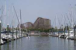 | |
|---|---|---|
| Other cities | ||
| CDPs and non- municipalities | ||
| Counties | ||
| Subregions | ||
| Bodies of water | ||
| Major ports | ||
| Nature preserves | ||
| Counties | 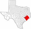 | |
|---|---|---|
| "Principal" cities | ||
| Other cities |
For a complete listing, see list of cities and towns in Houston–The Woodlands–Sugar Land MSA | |
| Unincorporated areas | ||
| Bodies of water | ||
Municipalities and communities of Galveston County, Texas, United States | ||
|---|---|---|
| Cities |  | |
| Village | ||
| CDPs | ||
| Unincorporated communities | ||
| Footnotes | ‡This populated place also has portions in an adjacent county or counties | |
