League City, Texas
| League City, Texas | |
|---|---|
| City | |
| City of League City | |
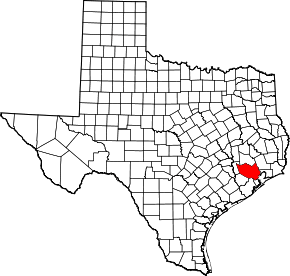
 Location in Galveston county and in the state of Texas | |
| Coordinates: 29°29′59″N 95°5′23″W / 29.49972°N 95.08972°WCoordinates: 29°29′59″N 95°5′23″W / 29.49972°N 95.08972°W | |
| Country |
|
| State |
|
| Counties | Galveston |
| Government | |
| • Type | Council-Manager |
| • Mayor | Pat Hallisey |
| • City Council |
Dan Becker Keith Gross Heidi Hansing Todd Kinsey Geri Bentley Nick Long |
| • City Manager | Mark Rohr[1] |
| Area | |
| • Total | 137.3 km2 (53.0 sq mi) |
| • Land | 132.8 km2 (51.3 sq mi) |
| • Water | 4.4 km2 (1.7 sq mi) |
| Elevation | 6 m (20 ft) |
| Population (2015) | |
| • Total | 98,312 |
| • Density | 720/km2 (1,900/sq mi) |
| Time zone | Central (CST) (UTC-6) |
| • Summer (DST) | CDT (UTC-5) |
| ZIP codes | 77573-77574 |
| Area code(s) | 281/346/713/832 |
| FIPS code | 48-41980[2] |
| GNIS feature ID | 1339753[3] |
| Website | http://www.leaguecity.com |
League City is a city in the U.S. state of Texas, within Houston–The Woodlands–Sugar Land metropolitan area. The city is in the county of Galveston As of the 2010 census, League City's population was 83,560,[4] up from 45,444 at the 2000 census. The city has a small portion north of Clear Creek within Harris County zoned for residential and commercial uses.[5]
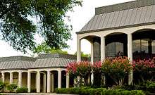
League City is home to several waterside resorts popular with residents of nearby Houston.
League City surpassed Galveston as Galveston County's largest city between 2000 and 2005.[6]
History
League City was settled at the former site of a Karankawa Indian village.[7] Three families, the Butlers, Cowarts, and Perkinses, are considered to be founding families of the city. The Cowart family settled on a creek now called Cowart's Creek after them (now often called "Coward's Creek"). The Perkins family built on a creek notably lined with magnolia trees, and named it Magnolia Bayou. The Butler family settled inland.
The first resident of the town proper, George W. Butler, arrived from Louisiana in 1873 and settled at the junction of Clear Creek and Chigger Bayou. The area was known as Butler's Ranch or Clear Creek until J. C. League acquired the land from a man named Muldoon on his entering the priesthood.[7] League laid out his town site along the Galveston, Houston, and Henderson Railroad, already established in the area. This began a small feud over the name, as Butler was the postmaster. The name was changed several times, alternating between Clear Creek and the new League City. In the end, League City was chosen.
In 1907, League had two railroad flatcars of live oak trees left by the railroad tracks. These were for the residents to plant on their property. Butler and his son Milby supervised the planting of these trees, now known as the Butler Oaks. Many of them line Main Street to this day.[8]
In the 2000s, rising real estate costs in Galveston forced many families to move to other areas, including League City. This meant an influx of children out of Galveston ISD and into other school districts like Clear Creek ISD and Dickinson ISD.[9]
In July 2013 the financial website NerdWallet named League City the best city in Texas for people looking for jobs.[10]
Geography

League City is located at 29°29′59″N 95°05′23″W / 29.499797°N 95.089784°W (29.499797, −95.089784).[11] This is 23 miles (37 km) southeast of Houston, and the same distance northwest of Galveston.
According to the United States Census Bureau, the city has a total area of 53.0 square miles (137.3 km2), of which 51.3 square miles (132.8 km2) is land and 1.7 square miles (4.4 km2), or 3.22%, is water.[12]
Climate
| Climate data for League City, Texas | |||||||||||||
|---|---|---|---|---|---|---|---|---|---|---|---|---|---|
| Month | Jan | Feb | Mar | Apr | May | Jun | Jul | Aug | Sep | Oct | Nov | Dec | Year |
| Record high °F (°C) | 86 (30) |
82 (28) |
86 (30) |
96 (36) |
93 (34) |
96 (36) |
100 (38) |
96 (36) |
93 (34) |
91 (33) |
80 (27) |
82 (28) |
100 (38) |
| Average high °F (°C) | 64 (18) |
66 (19) |
71 (22) |
80 (27) |
85 (29) |
90 (32) |
91 (33) |
91 (33) |
86 (30) |
82 (28) |
65 (18) |
63 (17) |
77.8 (25.5) |
| Average low °F (°C) | 42 (6) |
48 (9) |
52 (11) |
62 (17) |
66 (19) |
76 (24) |
76 (24) |
78 (26) |
74 (23) |
66 (19) |
51 (11) |
45 (7) |
61.3 (16.3) |
| Record low °F (°C) | 26 (−3) |
32 (0) |
28 (−2) |
42 (6) |
53 (12) |
69 (21) |
71 (22) |
73 (23) |
66 (19) |
57 (14) |
33 (1) |
33 (1) |
26 (−3) |
| Average precipitation inches (mm) | 3.90 (99.1) |
3.03 (77) |
2.77 (70.4) |
2.80 (71.1) |
3.64 (92.5) |
6.23 (158.2) |
5.28 (134.1) |
5.26 (133.6) |
6.88 (174.8) |
5.66 (143.8) |
4.43 (112.5) |
3.69 (93.7) |
53.57 (1,360.7) |
| Source: Weather Underground[13] | |||||||||||||
Demographics
| Historical population | |||
|---|---|---|---|
| Census | Pop. | %± | |
| 1970 | 10,818 | — | |
| 1980 | 16,578 | 53.2% | |
| 1990 | 30,159 | 81.9% | |
| 2000 | 45,444 | 50.7% | |
| 2010 | 83,560 | 83.9% | |
| Est. 2015 | 98,312 | [14] | 17.7% |
As of the census[2] of 2010, there were 83,560 people, 30,192 households, and 22,544 families residing in the city. The population density was 1,596 people per square mile (616.2/km2). There were 32,119 housing units at an average density of 627.3 per square mile (241.9/km2). The racial makeup of the city was 79.5% White, 7.1% Black or African American, 0.4% Native American, 5.4% Asian, 0.1% Pacific Islander, 4.7% some other race, and 2.9% from two or more races. Hispanic or Latino of any race were 17.3% of the population.[4]
There were 30,192 households out of which 40.4% had children under the age of 18 living with them, 60.3% were headed by married couples living together, 10.2% had a female householder with no husband present, and 25.3% were non-families. 20.3% of all households were made up of individuals, and 3.8% had someone living alone who was 65 years of age or older. The average household size was 2.75 and the average family size was 3.20.[4]
In the city the population was spread out with 28.5% under the age of 18, 7.3% from 18 to 24, 31.6% from 25 to 44, 25.3% from 45 to 64, and 7.3% who were 65 years of age or older. The median age was 34.5 years. For every 100 females there were 96.6 males. For every 100 females age 18 and over, there were 94.4 males.[4]
According to the 2007 American Community Survey estimate, the median income for a household in the city was $78,250, and the median income for a family was $88,338. Males had a median income of $52,366 versus $34,301 for females. The per capita income for the city was $27,170. About 3.6% of families and 4.8% of the population were below the poverty line, including 4.9% of those under age 18 and 6.0% of those age 65 or over.
Government and infrastructure

The United States Postal Service League City Post Office is located at 240 West Galveston Street.[16]
City government

League City became an incorporated city in 1962. League City’s government consists of seven council members and the mayor. The mayor only votes in the event of a tie vote of city council. The City's charter is purported to be a strong mayor form of government, but this issue has been debated for years. By ordinance, a city administrator position was created under Mayor Leonard Cruse. The administrator’s position does not carry the authority of a city manager under a council manager form of government. This administrator position does not have authority to conduct the city’s business without the constant approval of council and mayor. This ordinance has created a form of government recently referred to "Hybrid" of strong mayor and council manager forms of government.
In 2011 an officer accused the police chief, Michael Jez, of giving officers ticket quotas, which are illegal in the state of Texas. In November city council voted to place Chief Jez on administrative leave. The council did not give a reason and Jez cited philosophical differences for the separation. Much speculation was made that the decision was a reaction to the allegation made but neither side ever admitted to any wrongdoing.[17][18]
In 2014, the police department moved to a new joint Public Safety Building that is shared with Police and Fire administration as well as housing the police department, dispatch, and the city jail. The building is across the street from the old police department that now houses other city offices that were previously in leased space. The city held an open house in January 2015 to serve as a grand open to the public and allowing citizens to come see the inner workings of the police department.
Health care
In 2008 the University of Texas Medical Branch board of regents approved the creation of the 110,000-square-foot (10,000 m2) Specialty Care Center facility, located on 35 acres (140,000 m2) of land near Interstate 45, Farm to Market Road 646, and the Victory Lakes community.[19]
Education
Primary and secondary schools
Public schools
Clear Creek Independent School District is based in League City, and serves pupils in the Harris County portion and most of the Galveston County portion. Most pupils in League City attend schools in Clear Creek ISD. Some in Galveston County attend school in Dickinson ISD and Santa Fe ISD.
The CCISD portion of the city is divided between board of trustee districts 1, 4, and 5.[20][21][22] They are represented by Robert Allan Davee, Stuart J. Stromeyer, and Dee Scott, respectively, as of 2008.[23]
Clear Creek High School, of Clear Creek ISD, is located in League City. In fall 2007 Clear Springs High School opened in western League City.[24] In the fall of 2010 Clear Falls High School opened in the CCISD Education Village in southeastern League City. Clear Path Alternative School is also located in the city.
Ed White Memorial High School is a state charter school in League City.[25]
Private schools
Bay Area Christian School started in 1973 and currently has an enrollment of 674 students from grades K to 12.[26]
St. Mary School, a Roman Catholic K–8 school operated by the Roman Catholic Archdiocese of Galveston-Houston, is in League City.[27]
Colleges and universities
The Harris County portion of League City is served by San Jacinto College.[28] The Galveston County portion is served by the College of the Mainland.[29]
Public library
The Helen Hall Library, a member of the Galveston County Library System, is operated by the city and located at 100 West Walker Street.[30][31] The League City Public Library was renamed after Hall in 1985. During that year a $2.5 million bond to expand the 7,000-square-foot (650 m2) library passed. The library received a two-story adult services wing and a renovation of the original structure, which housed the children's and audio-visual services sections; the projects were completed by 1988. As of 2008 Hall, with 29,000 square feet (2,700 m2) of space, is the largest and busiest unit of the Galveston County Library System.[32]
Transportation
Houston Gulf Airport was located in eastern League City. The airport's land was sold and the land became a string of houses along Texas State Highway 96.[33]
Commercial airline service for the area is operated from George Bush Intercontinental Airport and William P. Hobby Airport, which are located in Houston. League City in conjunction with Island Transit, Connect Transit, and UTMB, there is now a Park and Ride in the Victory Lakes subdivision.
Parks and recreation
The 38,000-square-foot (3,500 m2) Perry Family YMCA is located at 1701 League City Parkway. The branch, which cost $10.7 million U.S. dollars to build was named after Bob Perry, a homebuilder who donated $1 million. The North Galveston County YMCA began in 1993 and later moved into the Perry YMCA. John P. McGovern and his wife, Katherine, donated the 17-acre (69,000 m2) site used for the Perry YMCA.[34]
See also
Climate
The climate in this area is characterized by hot, humid summers and generally mild to cool winters. According to the Köppen Climate Classification system, League City has a humid subtropical climate, abbreviated "Cfa" on climate maps.[35]
References
- ↑ http://leaguecity.com/Index.aspx?NID=829
- 1 2 "American FactFinder". United States Census Bureau. Retrieved 2008-01-31.
- ↑ "US Board on Geographic Names". United States Geological Survey. 2007-10-25. Retrieved 2008-01-31.
- 1 2 3 4 "Profile of General Population and Housing Characteristics: 2010 Demographic Profile Data (DP-1): League City city, Texas". U.S. Census Bureau, American Factfinder. Retrieved January 6, 2012.
- ↑ http://tx-leaguecity.civicplus.com/DocumentView.asp?DID=61
- ↑ Schladen, Marty. "Forces drive people off island." Galveston County Daily News. Retrieved on December 6, 2008.
- 1 2 J., KLEINER, DIANA. "LEAGUE CITY, TX". tshaonline.org. Retrieved 2016-01-08.
- ↑ "League City Historical Society - League City, Texas". leaguecityhistory.org. Retrieved 2016-01-08.
- ↑ http://www.galvestondailynews.com/story.lasso?ewcd=cecba57d52dda271
- ↑ Hlavaty, Craig. "Two Houston suburbs named among best in Texas for jobs." Houston Chronicle. July 30, 2013. Retrieved on July 31, 2013.
- ↑ "US Gazetteer files: 2010, 2000, and 1990". United States Census Bureau. 2011-02-12. Retrieved 2011-04-23.
- ↑ "Geographic Identifiers: 2010 Demographic Profile Data (G001): League City city, Texas". U.S. Census Bureau, American Factfinder. Retrieved January 6, 2012.
- ↑ "Weather History for Ellington Field, TX". Weather Underground. Weather Underground. Retrieved November 25, 2014.
- ↑ "Annual Estimates of the Resident Population for Incorporated Places: April 1, 2010 to July 1, 2015". Retrieved July 2, 2016.
- ↑ "Census of Population and Housing". Census.gov. Retrieved June 4, 2015.
- ↑ "Post Office Location – LEAGUE CITY." United States Postal Service. Retrieved on December 6, 2008.
- ↑ "Golden Parachute." The Bay Area Citizen. Wednesday December 7, 2011.
- ↑ "Police Chief Accused Of Issuing Ticket Quota." KRPC. Monday October 31, 2011. Retrieved on November 2, 2011.
- ↑ Elder, Laura. "UTMB gets OK for Victory Lakes project." The Galveston Daily News. May 16, 2008. Retrieved on February 12, 2009.
- ↑ District 1 Map. Clear Creek Independent School District. Retrieved on December 6, 2008.
- ↑ District 4 Map. Clear Creek Independent School District. Retrieved on December 6, 2008.
- ↑ District 5 Map. Clear Creek Independent School District. Retrieved on December 6, 2008.
- ↑ "School Board Members: Bios and Contact Information." Clear Creek Independent School District. Retrieved on December 6, 2008.
- ↑ http://www.ccisd.net/community_05/district_committees/listing/springs.JPG
- ↑ http://www.bayareacharter.com/edwhitememorialhighschool.htm
- ↑ Bay Area Christian School
- ↑ http://www.stmarycatholicschool.com/
- ↑ Texas Education Code, Section 130.197, "San Jacinto College District Service Area".
- ↑ Texas Education Code, Section 130.174, "College of the Mainland District Service Area".
- ↑ "Galveston County Library System"
- ↑ "Map & Directions." Helen Hall Library. Retrieved on December 6, 2008.
- ↑ "History." Helen Hall Library. Retrieved on December 6, 2008.
- ↑ Rendon, Ruth. "Fees could slow growth / Developers expected to balk at League City plan." Houston Chronicle. Sunday November 2, 2003. A29 MetFront.
- ↑ Evans, Thayer. "CONSTRUCTION UPDATE / YMCA begins taking shape / Facility slated to open later this year in League City." Houston Chronicle. Thursday May 31, 2007. ThisWeek 1.
- ↑ Climate Summary for League City, Texas
External links
- City of League City official website
- League City from the Handbook of Texas Online
| Counties | 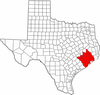 | |
|---|---|---|
| "Principal" cities | ||
| Other cities |
For a complete listing, see list of cities and towns in Houston–The Woodlands–Sugar Land MSA | |
| Unincorporated areas | ||
| Bodies of water | ||
Municipalities and communities of Galveston County, Texas, United States | ||
|---|---|---|
| Cities |  | |
| Village | ||
| CDPs | ||
| Unincorporated communities | ||
| Footnotes | ‡This populated place also has portions in an adjacent county or counties | |