Clear Lake Shores, Texas
| Clear Lake Shores, Texas | |
|---|---|
| City | |
| Motto: "The Yachting Capital of Texas" | |
|
Location of Clear Lake Shores, Texas | |
| Coordinates: 29°32′47″N 95°1′57″W / 29.54639°N 95.03250°WCoordinates: 29°32′47″N 95°1′57″W / 29.54639°N 95.03250°W | |
| Country | United States |
| State | Texas |
| County | Galveston |
| Area | |
| • Total | 0.7 sq mi (1.7 km2) |
| • Land | 0.5 sq mi (1.2 km2) |
| • Water | 0.2 sq mi (0.5 km2) |
| Elevation | 10 ft (3 m) |
| Population (2010) | |
| • Total | 1,063 |
| • Density | 1,500/sq mi (630/km2) |
| Time zone | Central (CST) (UTC-6) |
| • Summer (DST) | CDT (UTC-5) |
| ZIP code | 77565 |
| Area code(s) | 281 |
| FIPS code | 48-15328[1] |
| GNIS feature ID | 1332954[2] |
Clear Lake Shores is a city in Galveston County, Texas, within the Houston–Sugar Land–Baytown metropolitan area. Clear Lake Shores is regarded as "The Yachting Capital of Texas", as the city has more boat slips than people. As of the 2010 census, the city population was 1,063.[3]
History
During the oil boom years of the 1920s, developers began to sell properties around the Clear Lake estuary as waterfront recreational retreats. The new development was named "Clear Lake Shores". Though the development was initially successful, the Great Depression halted most of the area's growth.[4]
After World War II the area began to redevelop with increasing numbers of permanent residents (as opposed to simply weekend residents). The town incorporated in 1962 and has since continued to be primarily residential with a small, tourism-focused business community.
In September 2008, the eye of Hurricane Ike hit and destroyed many homes.[5]
Geography
Clear Lake Shores is located at 29°32′47″N 95°1′57″W / 29.54639°N 95.03250°W (29.546493, -95.032605)[6] and is part of the Clear Lake Area.
According to the United States Census Bureau, the city has a total area of 0.6 square miles (1.6 km2), of which 0.5 square miles (1.3 km2) is land and 0.2 square miles (0.52 km2), or 27.69%, is water.
All Clear Lake Shores addresses share the 77565 zip code with the city of Kemah.
Demographics
| Historical population | |||
|---|---|---|---|
| Census | Pop. | %± | |
| 1970 | 721 | — | |
| 1980 | 755 | 4.7% | |
| 1990 | 1,096 | 45.2% | |
| 2000 | 1,205 | 9.9% | |
| 2010 | 1,063 | −11.8% | |
| Est. 2015 | 1,169 | [7] | 10.0% |
As of the census[1] of 2000, there were 1,205 people, 590 households, and 338 families residing in the city. The population density was 2,581.9 people per square mile (989.9/km²). There were 661 housing units at an average density of 1,416.3 per square mile (543.0/km²). The racial makeup of the city was 1143 (94.85%) White, 4 (0.33%) African American, 4 (0.33%) Native American, 9 (0.75%) Asian, 12 (1.00%) from other races, and 33 (2.74%) from two or more races. Hispanic or Latino of any race were 40 (3.32%) of the population.
There were 590 households out of which 20.5% had children under the age of 18 living with them, 45.8% were married couples living together, 7.1% had a female householder with no husband present, and 42.7% were non-families. 35.4% of all households were made up of individuals and 6.3% had someone living alone who was 65 years of age or older. The average household size was 2.04 and the average family size was 2.60.
In the city the population was spread out with 16.7% under the age of 18, 5.1% from 18 to 24, 29.5% from 25 to 44, 40.0% from 45 to 64, and 8.8% who were 65 years of age or older. The median age was 44 years. For every 100 females there were 103.9 males. For every 100 females age 18 and over, there were 108.3 males.
The median income for a household in the city was $67,500, and the median income for a family was $86,450. Males had a median income of $65,375 versus $41,563 for females. The per capita income for the city was $41,347. About 3.0% of families and 4.2% of the population were below the poverty line, including 0.5% of those under age 18 and 7.5% of those age 65 or over.
Government and infrastructure
Clear Lake Shores has a police department.[9] The Kemah Volunteer Fire Department, with its facility in Kemah, serves Clear Lake Shores.[10]
Education
Clear Lake Shores is served by the Clear Creek Independent School District. The community is within the Board of Trustee District 1,[11] represented by Laura DuPont [12]
Pupils are zoned to Stewart Elementary School (formerly Kemah Elementary School) in Kemah,[13] Bayside Intermediate School in League City,[14] and Clear Falls High School in League City.[15] Previously residents were zoned to Clear Creek High School in League City.[16]
Residents are zoned to the College of the Mainland, a community college in Texas City.[17][18]
See also
References
- 1 2 "American FactFinder". United States Census Bureau. Archived from the original on 2013-09-11. Retrieved 2008-01-31.
- ↑ "US Board on Geographic Names". United States Geological Survey. 2007-10-25. Retrieved 2008-01-31.
- ↑ "Profile of General Population and Housing Characteristics: 2010 Demographic Profile Data (DP-1): Clear Lake Shores city, Texas". U.S. Census Bureau, American Factfinder. Archived from the original on September 11, 2013. Retrieved January 6, 2012.
- ↑ Jasinski, Laurie E.: Clear Lake Shores, Texas from the Handbook of Texas Online Texas State Historical Association.
- ↑ "News briefs." Houston Chronicle. Tuesday April 23, 1991. A14.
- ↑ "US Gazetteer files: 2010, 2000, and 1990". United States Census Bureau. 2011-02-12. Retrieved 2011-04-23.
- ↑ "Annual Estimates of the Resident Population for Incorporated Places: April 1, 2010 to July 1, 2015". Retrieved July 2, 2016.
- ↑ "Census of Population and Housing". Census.gov. Archived from the original on May 11, 2015. Retrieved June 4, 2015.
- ↑ "Police Department." City of Clear Lake Shores. Retrieved on March 23, 2014.
- ↑ "Fire Department." City of Clear Lake Shores. Retrieved on March 23, 2014.
- ↑ District 1 Map. Clear Creek Independent School District. Retrieved on May 11, 2013.
- ↑ "School Board Members: Bios and Contact Information." Clear Creek Independent School District. Retrieved on May 11, 2013.
- ↑ "Stewart Elementary School Boundary Archived September 28, 2011, at the Wayback Machine.." Clear Creek Independent School District. Retrieved on December 6, 2008.
- ↑ "Bayside Intermediate School Boundary Archived September 28, 2011, at the Wayback Machine.." Clear Creek Independent School District. Retrieved on December 6, 2008.
- ↑ "Clear Falls High School Boundary Archived March 23, 2014, at the Wayback Machine.." Clear Creek Independent School District. Retrieved on March 23, 2014.
- ↑ "Clear Creek High School Boundary." Clear Creek Independent School District. Retrieved on December 6, 2008.
- ↑ Texas Education Code, Section 130.174, "College of the Mainland District Service Area".
- ↑ "Welcome to College of the Mainland." College of the Mainland. Retrieved on December 8, 2008.
External links
| Large cities | 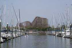 | |
|---|---|---|
| Other cities | ||
| CDPs and non- municipalities | ||
| Counties | ||
| Subregions | ||
| Bodies of water | ||
| Major ports | ||
| Nature preserves | ||
| Counties | 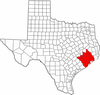 | |
|---|---|---|
| "Principal" cities | ||
| Other cities |
For a complete listing, see list of cities and towns in Houston–The Woodlands–Sugar Land MSA | |
| Unincorporated areas | ||
| Bodies of water | ||
Municipalities and communities of Galveston County, Texas, United States | ||
|---|---|---|
| Cities |  | |
| Village | ||
| CDPs | ||
| Unincorporated communities | ||
| Footnotes | ‡This populated place also has portions in an adjacent county or counties | |
