Deer Park, Texas
| Deer Park, Texas | |
|---|---|
| City | |
| Nickname(s): "Birthplace of Texas" | |
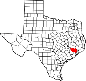
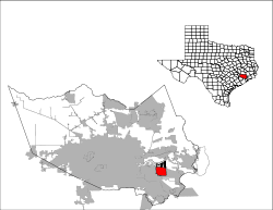 Location in Harris County in the state of Texas | |
| Coordinates: 29°41′31″N 95°07′05″W / 29.69194°N 95.11806°W | |
| Country |
|
| State |
|
| County | Harris |
| Incorporated | 1948 |
| Government | |
| • Type | Council-Manager |
| • City Council |
Mayor Jerry Mouton, Jr. Sherry Garrison Thane Harrison Tommy Ginn Bill Patterson Ron Martin Rae Sinor |
| • City Manager | James Stokes |
| Area | |
| • Total | 10.4 sq mi (26.8 km2) |
| • Land | 10.4 sq mi (26.8 km2) |
| • Water | 0.0 sq mi (0.0 km2) |
| Elevation | 24 ft (7.3 m) |
| Population (2010) | |
| • Total | 32,010 |
| • Density | 3,100/sq mi (1,200/km2) |
| Time zone | CST (UTC-6) |
| • Summer (DST) | CDT (UTC-5) |
| ZIP code | 77536 |
| Area code(s) | 281 |
| FIPS code | 48-19624[1] |
| GNIS feature ID | 1334219[2] |
| Website | deerparktx.gov/ |
Deer Park is a city in the U.S. state of Texas within the Houston–Sugar Land–Baytown metropolitan area. The city is located in Harris County and is situated in Southeast Texas. As of the 2010 U.S. Census, the population of Deer Park was 32,010.
History
Deer Park was founded in 1892 by Simeon Henry West, a farmer, retired legislator, and much-traveled adventurer from Illinois. He named the town for the large number of deer that roamed the Gulf plains. A railroad station opened later that year and a post office followed in 1893.[3]
The subdivision was established in 1893 and was the site of a Galveston, Harrisburg and San Antonio Railway station by about 1894. A Deer Park post office was established in 1893, discontinued in 1919, and reestablished in 1930. In 1896, the community, with a population of forty, had a hotel, a general store, and three resident carpenters. By 1922 Deer Park had dwindled down to almost nothing with four houses, one little schoolhouse, and an old hotel with a few scattered shacks along the railroad right-of-way. 1928 brought in Shell Oil Company breaking ground on a new refinery. In the 1930s, an independent school district was established. By 1940, the population had grown to 100. By 1946, however, the area began to flourish as Deer Park became the site of refineries and toluene plants for the production of TNT.
The citizens of Deer Park voted to incorporate on December 12, 1948, and a few weeks later Earl E. Dunn became the first mayor. Because of the 1948 incorporation, Houston did not incorporate Deer Park's territory into its city limits.[4] The first city council meeting was held on February 7, 1949. The population had grown to 700 by 1948, to 5,000 by 1960 with a fire station, city hall, playground parks and an independent city water supply. A public library was begun in 1962. Population was 12,773 in 1970, and 28,520 in 2000. This growth has been fueled by the growth of the petrochemical industry as well as the growth of business along the Houston Ship Channel. Deer Park has a school district with 14 campuses, a city library, community theater, municipal court building, three fire stations, numerous city parks and recreational facilities, state-of-the-art water and sewer processing facilities, a post office, several hotels, 14 major industries as well as several light industrial companies. Today, Deer Park has approximately 9,000 homes and more than 30,000 residents.
It is near the site of the Battle of San Jacinto, where, on April 21, 1836, Texas won its independence from Mexico. Because the initial surrender treaty after the battle was signed in Dr. George Moffitt Patrick's cabin, Deer Park bills itself as the "Birthplace of Texas". The original cabin was located on Buffalo Bayou where Rohm and Haas now has a chemical plant in Deer Park. A replica of Dr. Patrick's cabin is in front of the Theatre/Courts Building on Center Street.
Shell Chemical plant explosion
On June 22, 1997, an ethylene explosion occurred at the nearby Shell Chemical Company plant that was heard and felt as far as 25 miles (40 km) away. While no evacuation of the city was ordered, residents living within a mile west of the plant were advised to remain inside their homes.[5]
Geography
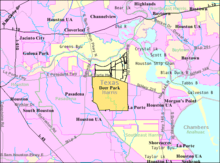
Deer Park is located at 29°41′31″N 95°7′5″W / 29.69194°N 95.11806°W (29.692003, -95.118108).[6] According to the United States Census Bureau, the city has a total area of 10.4 square miles (27 km2), all of it land.
Deer Park is bounded by the cities of Pasadena and La Porte to the east, south, and west, and by the Houston Ship Channel—the dredged-out Buffalo Bayou—to the north.
Demographics
| Historical population | |||
|---|---|---|---|
| Census | Pop. | %± | |
| 1950 | 736 | — | |
| 1960 | 4,865 | 561.0% | |
| 1970 | 12,773 | 162.5% | |
| 1980 | 22,648 | 77.3% | |
| 1990 | 27,652 | 22.1% | |
| 2000 | 28,520 | 3.1% | |
| 2010 | 32,010 | 12.2% | |
| Est. 2015 | 33,806 | [7] | 5.6% |
As of the census[1] of 2000, there were 28,520 people, 9,615 households, and 7,941 families residing in the city. The population density was 2,752.7 people per square mile (1,062.9/km²). There were 9,921 housing units at an average density of 957.6 per square mile (369.7/km²). The racial makeup of the city was 90.01% White, 1.31% African American, 0.41% Native American, 1.13% Asian, 0.13% Pacific Islander, 5.25% from other races, and 1.76% from two or more races. Hispanic or Latino of any race were 15.22% of the population.
There were 9,615 households out of which 43.6% had children under the age of 18 living with them, 66.8% were married couples living together, 11.5% had a female householder with no husband present, and 17.4% were non-families. 14.0% of all households were made up of individuals and 4.2% had someone living alone who was 65 years of age or older. The average household size was 2.93 and the average family size was 3.23.
In the city the population was spread out with 29.0% under the age of 18, 9.4% from 18 to 24, 30.3% from 25 to 44, 23.9% from 45 to 64, and 7.4% who were 65 years of age or older. The median age was 35 years. For every 100 females there were 98.7 males. For every 100 females age 18 and over, there were 96.2 males.
The median income for a household in the city was $61,334, and the median income for a family was $66,516. Males had a median income of $50,867 versus $30,926 for females. The per capita income for the city was $24,440. About 4.0% of families and 5.6% of the population were below the poverty line, including 5.4% of those under age 18 and 4.9% of those age 65 or over.
Government
The Deer Park Post Office is located at 200 East San Augustine Street.[9]
Electoral districts
United States Congressional District
- US Representative Brian Babin (R)
Texas State Senate Districts
- Texas Senate District 11[10]
- Texas Senator Mike Jackson (R)
- Senate District 6[11]
- Texas Senator Mario Gallegos, Jr. (D)
Texas State Congressional Districts
- Texas House District 144
- Representative Ken Legler (R)
- Texas House District 128
- Representative Wayne Smith (R)
Education
Primary and secondary education
Public schools
Most Deer Park pupils attend schools in Deer Park Independent School District. Some attend school in the La Porte Independent School District.
Deer Park High School serves the DPISD portion. La Porte High School serves the LPISD portion. Deer Park has 4 junior high schools, Deer Park Junior High, Bonnette Junior High, Fairmont Junior High and Deepwater Junior High. There are 7 elementary schools that serve the area as well.Deer Park ISD has an open enrollment program that allows students that do not reside within the boundaries of DPISD to attend DPISD Schools. Many students who live within La Porte ISD choose to attend school in Deer Park due to higher Texas Education Agency ratings.
Colleges
Deer Park is also served by the San Jacinto College District, Central Campus.
Public libraries
The city operates the Deer Park Library at 3009 Center Street.[12]
Notable people
- Briscoe Cain, Republican member of the Texas House of Representatives, effective 2017
- Charles Holcomb, judge of the Texas Court of Criminal Appeals, 2001-2010, is a former city attorney for Deer Park.
- Andy Pettitte, MLB pitcher for the New York Yankees[13]
Climate
The climate in this area is characterized by hot, humid summers and generally mild to cool winters. According to the Köppen Climate Classification system, Deer Park has a humid subtropical climate, abbreviated "Cfa" on climate maps.[14]
References
- 1 2 "American FactFinder". United States Census Bureau. Retrieved 2008-01-31.
- ↑ "US Board on Geographic Names". United States Geological Survey. 2007-10-25. Retrieved 2008-01-31.
- ↑ "History of Deer Park ~ Deer Park, Texas". History of Deer Park ~ Deer Park, Texas. City of Deer Park, Texas. Retrieved 26 July 2011.
- ↑ Lee, Renée C. "Annexed Kingwood split on effects." Houston Chronicle. Sunday October 8, 2006. A21. Retrieved on July 6, 2011. "Some of the area communities that incorporated as cities and escaped annexation by Houston:" Print version exclusively has the information cited; the information is not included in the online edition.
- ↑ "TCC Meeting Hears Details Of Deer Park Shell Explosion-22/06/1998-CMR". Icis.com. Retrieved 2011-08-19.
- ↑ "US Gazetteer files: 2010, 2000, and 1990". United States Census Bureau. 2011-02-12. Retrieved 2011-04-23.
- ↑ "Annual Estimates of the Resident Population for Incorporated Places: April 1, 2010 to July 1, 2015". Retrieved July 2, 2016.
- ↑ "Census of Population and Housing". Census.gov. Retrieved June 4, 2015.
- ↑ "Post Office Location - DEER PARK." United States Postal Service. Retrieved on December 6, 2008.
- ↑ "Who Represents Me?". Retrieved 20 July 2011.
- ↑ "Members of the Texas State Senate". The Senate of Texas. Retrieved 20 July 2011.
- ↑ "Hours." Deer Park Library. Retrieved on December 6, 2008.
- ↑ "Former Gators Pettitte And Clemens Come Home". Gators Baseball History. San Jacinto College. Archived from the original on 2007-09-27. Retrieved 2008-02-06.
- ↑ Climate Summary for Deer Park, Texas
External links
- City of Deer Park
- Deer Park, Texas from the Handbook of Texas Online
Coordinates: 29°41′31″N 95°07′05″W / 29.692003°N 95.118108°W
| Counties | 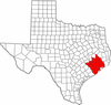 | |
|---|---|---|
| "Principal" cities | ||
| Other cities |
For a complete listing, see list of cities and towns in Houston–The Woodlands–Sugar Land MSA | |
| Unincorporated areas | ||
| Bodies of water | ||