Stafford, Texas
| Stafford, Texas | |
|---|---|
| City | |
|
Monument on US 90 Alternate | |
| Motto: "City with no property taxes" | |
 Location of Stafford, Texas | |
| Coordinates: 29°37′27″N 95°33′48″W / 29.62417°N 95.56333°WCoordinates: 29°37′27″N 95°33′48″W / 29.62417°N 95.56333°W | |
| Country |
|
| State |
|
| Counties | Fort Bend, Harris |
| Government | |
| • Type | Mayor-Council |
| • Mayor | Leonard Scarcella |
| • City Council |
Wen Guerra Felecia Evans-Smith Ken Mathew Robert Sorbet Cecil Willis Fred Woolridge |
| Area | |
| • Total | 18.2 km2 (7.0 sq mi) |
| • Land | 18.1 km2 (7.0 sq mi) |
| • Water | 0.1 km2 (0.04 sq mi) |
| Elevation | 26 m (85 ft) |
| Population (2010) | |
| • Total | 17,693 |
| • Density | 976.8/km2 (2,530/sq mi) |
| Time zone | Central (CST) (UTC-6) |
| • Summer (DST) | CDT (UTC-5) |
| ZIP codes | 77477, 77497 |
| Area code(s) | 281 |
| FIPS code | 48-69908[1] |
| GNIS feature ID | 1347777[2] |
| Website |
www |

Stafford is a city in the U.S. state of Texas, within the Houston–The Woodlands–Sugar Land metropolitan area. The city is mostly in Fort Bend County, with a small portion in Harris County. As of the 2010 census, Stafford's population was 17,693,[3] up from 15,681 at the 2000 census. As of 2015 the population had risen to an estimated 18,459.[4]
History
William Stafford established a plantation with a cane mill and a horse-powered cotton gin in 1830. On April 15, 1836, during the Texas Revolution, the forces of Antonio López de Santa Anna stopped at Stafford's plantation and ordered it to be burned. Stafford rebuilt his plantation and resided there until his 1840 death. A settlement called "Stafford's Point" established itself around the plantation; it became a townsite in August 1853 when the Buffalo Bayou, Brazos and Colorado Railway began stopping there. Stafford's Point had a post office from 1854 to 1869. "Staffordville" had a post office from January 5, 1869 to February 26, 1869. The settlement, now known as "Stafford", operated a post office from 1869 to 1918; the post office reopened in 1929.[5]
In 1884, Stafford had 50 residents, two general stores, and a grocer. By 1896, the settlement had a population of 300. By 1914, the population fell to 100. In 1931, 320 people lived in Stafford. This increased to 400 residents in 1946. Stafford incorporated as a city in 1956.[5]
Geography

Stafford is located in eastern Fort Bend County at 29°37′27″N 95°33′48″W / 29.62417°N 95.56333°W (29.624186, -95.563359).[6] A small portion of the city extends northeast into Harris County. It is bordered by the city of Houston to the north, Meadows Place to the northwest, Sugar Land to the west, and Missouri City to the south and east.
The Southwest Freeway (Interstate 69) passes through the northwest part of Stafford, leading northeast 16 miles (26 km) to the center of Houston and southwest 18 miles (29 km) to Rosenberg. U.S. 90 Alternate passes through Stafford as Main Street, leading west 5 miles (8 km) to Sugar Land and northeast 18 miles (29 km) to the Houston East End.
According to the United States Census Bureau, Stafford has a total area of 7.0 square miles (18.2 km2), of which 7.0 square miles (18.1 km2) is land and 0.04 square miles (0.1 km2), or 0.58%, is water.[3]
Climate
The climate in this area is characterized by hot, humid summers and generally mild to cool winters. According to the Köppen Climate Classification system, Stafford has a humid subtropical climate, Cfa on climate maps.[7]
Extraterritorial jurisdiction
The city of Stafford has several areas of extraterritorial jurisdiction. Two ETJ areas are within the Houston Independent School District, including an area at Beltway 8 and Stafford Road and another area between Beltway 8 and Murphy Road. One ETJ area within the Alief Independent School District is next to the City of Meadows Place along Interstate 69/U.S. Route 59. Areas in the Fort Bend Independent School District include a portion of the Fifth Street and an area around U.S. Route 90 Alternate, Dulles Avenue, and Avenue E. The City of Stafford has avoided annexing these areas, because doing so would give it territory in school districts other than the Stafford Municipal School District (SMSD) and the city wants its city limits and the SMSD to have the same area. The SMSD cannot annex these areas without the permission of the other school districts.[8]
Demographics
| Historical population | |||
|---|---|---|---|
| Census | Pop. | %± | |
| 1960 | 1,485 | — | |
| 1970 | 2,906 | 95.7% | |
| 1980 | 4,755 | 63.6% | |
| 1990 | 8,397 | 76.6% | |
| 2000 | 15,681 | 86.7% | |
| 2010 | 17,693 | 12.8% | |
| Est. 2015 | 18,459 | [4] | 4.3% |
As of the census[1] of 2010, there were 17,693 people, 6,750 households, and 4,483 families residing in the city. The population density was 2,527.6 people per square mile (867.4/km²). There were 7,074 housing units at an average density of 1010.6 per square mile (353.5/km²). The racial makeup of the city was 36.6% White, 27.4% African American, 0.6% Native American, 22.8% Asian, 0.0% Pacific Islander, 9.3% some other race, and 3.2% from two or more races. Hispanic or Latino of any race were 25.9% of the population.
There were 6,750 households out of which 33.2% had children under the age of 18 living with them, 45.1% were married couples living together, 16.3% had a female householder with no husband present, and 33.6% were non-families. 27.9% of all households were made up of individuals living alone, and 4.8% of individuals living alone were 65 years of age or older. The average household size was 2.62 and the average family size was 3.25.
In the city, the population was spread out with 24.8% under the age of 18, 10.8% from 18 to 24, 32.7% from 25 to 44, 24.4% from 45 to 64, and 7% who were 65 years of age or older. The median age was 31.9 years. For every 100 females there were 94.5 males. For every 100 females age 18 and over, there were 90.9 males.[10]
The median income for a household in the city was $61,084, and the median income for a family was $63,244. Males had a median income of $46,023 versus $40,549 for females. The per capita income for the city was $27,082. About 6.3% of families and 9.0% of the population were below the poverty line, including 10.4% of those under age 18 and 9.3% of those age 65 or over.
Economy
Stafford has not had a municipal property tax since 1995. Even though it is known as a bedroom community of the greater Houston area, an estimated four times as many people work in Stafford on a week day, which is evidence of the large amount of commercial activity that helps the city financially. Many corporations both large and small, including the United Parcel Service and Tyco, maintain significant operations in Stafford.

Originally, Stafford was an agricultural community. As of 2009, it has operations from commercial, manufacturing, retail, service, and wholesale industries which pay sales and franchise taxes to the city. Stafford is known internationally for attracting valve manufacturing companies; 11 are located here. Stafford has 15 business parks, one shopping center, and 19 hotels and motels.[11]
Texas Instruments (TI) operates a production facility in Stafford, where it manufactures 6-inch (150 mm) wafers used in cell phones, high-definition televisions, and solar devices. The plant first opened in 1967.[12] In 2009, TI, which had around 1,500 employees in its Stafford office during that year, was the largest employer in the city.[11] In 2012, the company announced it is closing its Stafford plant because industry demand for larger, more efficient wafers increased and the company, in lieu of upgrading the Stafford plant to accommodate production of larger wafers, opted to shift production to newer plants.[12] Of the 1,000 employees at the plant during that year, TI laid off 500 and sent 500 to another facility. Leonard Scarcella, the Mayor of Stafford, said that the closure would adversely affect Stafford.[13]
About 15 years ago, TI comprised about 25% of the city's economy and by 2012 it stood at about one-tenth of that, or 2.5%.[14] Some jobs at the plant were scheduled to end in July 2012. Other jobs were scheduled to remain until the factory's closure in late 2012. TI stated it plans opening another facility in Greater Houston for the 500 remaining employees.[12] In 2012 TI announced that it was relocating its Fort Bend County operations to the Telfair area in Sugar Land.[15]
Parks and recreation

About 35.6 acres (144,000 m2) of greenspace in Stafford are designated as municipal parks. Stafford City Park, the largest, covers 16 acres (65,000 m2) of land. The park includes baseball and softball fields, basketball courts, a pavilion, playground equipment, picnic benches, and soccer (football)/open fields. Gordon Fountain Lake Park, covering 9 acres (36,000 m2), is the second largest park in Stafford. It has a 1/2-mile lighted jogging trail, a lake, a pavilion, picnic benches, and playground equipment. The 4.5-acre (18,000 m2) Vaccaro Manor Park has a lighted quarter-mile jogging trail, a pavilion, playground equipment, sidewalks, and soccer/open fields. The 3.14-acre (12,700 m2) Rubin Park has playground equipment and picnic benches. First Street Park has 3 acres (12,000 m2) of land and includes baseball/softball fields, a jogging trail, lighting, and picnic benches. The Margaret Havens Historical Memorial Garden is located next to Stafford City Hall. Its rose garden, benches, and fountain have attracted many couples to be married there.[16] Stafford operates a Civic Center and a City Pool in the Municipal Complex. City residents pay $10 each year for pool access. The Stafford Centre Performing Arts Theatre and Convention Centre boasts a 1,100-seat performing arts theater; 25,000 square feet of meeting, banquet, and exposition space, including a 20,000-ft2 ballroom; and over 28 acres of outdoor festival green space.[17]
Fort Bend County operates the 5-acre (20,000 m2) Stafford Community Center in Fifth Street, an unincorporated area near Stafford.[18]
Government


Local government
The City of Stafford stopped levying nonschool property taxes in 1995. It is the only Houston-area city and is the highest populated city in Texas to do so. Sales and franchise taxes from businesses fund the city.[11]
As of 2012, the mayor of Stafford is Leonard Scarcella, who was first elected in 1969. He has been a lifelong resident of the city.
The Stafford City Hall, Stafford Police Department, and Municipal Court buildings are located on South Main, adjacent to one another.[19] The Stafford Volunteer Fire Department operates out of three fire stations.[20]
County, state, and federal representation
Stafford is partially located in Fort Bend County and partially in Harris County. Residents pay property taxes to their respective counties.[11]
Harris County Precinct One, headed by El Franco Lee as of 2012, serves the section of Stafford in Harris County.[21][22]
Much of Stafford is located in District 26 of the Texas House of Representatives. As of 2012, Charlie Howard represents the district.[23] Some of Stafford is located in District 27 of the Texas House of Representatives. As of 2012, Ron Reynolds represents the district.[24] Most of Stafford is within District 13 of the Texas Senate; as of 2012, Rodney Ellis represents that district.[25] Some of Stafford is within District 17 of the Texas Senate; as of 2012, Joan Huffman represents that district.[26]
Stafford is in Texas's 22nd congressional district. As of 2012, Pete Olson represents the district.[27]
Media
The Fort Bend Star, a weekly newspaper, is headquartered in Stafford.[28] The Houston Chronicle is the area's newspaper of record.
Education
Colleges and universities
The city is served by the Houston Community College System. The HCCS Southwest College includes the Stafford Campus at 10041 Cash Road. In spring 2012, the headcount enrollment at the Stafford Campus was 8,139.[29]
Primary and secondary schools

Public schools
The city has the only municipal school district (Stafford Municipal School District) in all of Texas. In 1977, Stafford broke away from the Fort Bend Independent School District, which caused several rounds of federal litigation; and, by 1981, it was finally declared that the Stafford Municipal School District was constitutional. Almost all of Stafford was in FBISD, with a minuscule portion in the Houston Independent School District. All of Stafford is now zoned to the Stafford Municipal School District, which is the only municipal school district in Texas that is controlled by the city. Residents pay property taxes to the school district.[11]
When most of Stafford was a part of Fort Bend ISD, Staffordshire Elementary was located in Stafford. Staffordshire housed Black students in grades 1-4. Staffordshire closed in September 1965 when Fort Bend ISD desegregated. The district later sold the Staffordshire property.[30]
Private schools
Everest Academy (PreK-5),[31] - PreK-5[32] a school of the Darul Arqam Schools, is in Stafford.[33]
Public libraries
Fort Bend County Libraries has the Mamie George Branch located within the city limits of Sugar Land on Dulles Avenue right next to Dulles Middle School.[34][35] The Mamie George Library, a 4,900 square feet (460 m2) library designed by Wylie W. Vale and Associates, opened in November 1974. The library was named after Mamie George, a philanthropist from Fort Bend County. The George Foundation donated funds for the building, and the Fort Bend Independent School District donated the land that the library was built on. The library was renovated in 1991. In 1996 the small-business-center materials were moved from the Missouri City Branch to the Mamie George Branch.[36]
Infrastructure
The United States Postal Service operates the Stafford Post Office at 4110 Bluebonnet Drive.[37]
Gallery
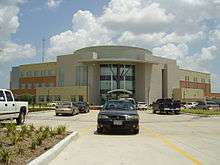
 Stafford Municipal Court
 Stafford Police Department, part of the J.C. "Buster" Public Safety Complex
 Fire Station No. 1, part of the J.C. "Buster" Court Public Safety Complex
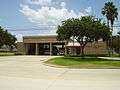 Northside Fire Station
 Stafford Centre for the Performing Arts
 Stafford Post Office
References
- 1 2 "American FactFinder". United States Census Bureau. Retrieved 2008-01-31.
- ↑ "US Board on Geographic Names". United States Geological Survey. 2007-10-25. Retrieved 2008-01-31.
- 1 2 "Geographic Identifiers: 2010 Demographic Profile Data (G001): Stafford city, Texas". U.S. Census Bureau, American Factfinder. Retrieved August 31, 2016.
- 1 2 "Annual Estimates of the Resident Population for Incorporated Places: April 1, 2010 to July 1, 2015". Retrieved July 2, 2016.
- 1 2 Stafford, Texas from the Handbook of Texas Online
- ↑ "US Gazetteer files: 2010, 2000, and 1990". United States Census Bureau. 2011-02-12. Retrieved 2011-04-23.
- ↑ Climate Summary for Stafford, Texas
- ↑ Kumar, Seshadri. "Stafford, SMSD mull over annexation." Houston Chronicle. October 30, 2006. Retrieved on April 12, 2014.
- ↑ "Census of Population and Housing". Census.gov. Retrieved June 4, 2015.
- ↑ "Profile of General Population and Housing Characteristics: 2010 Demographic Profile Data (DP-1): Stafford city, Texas". U.S. Census Bureau, American Factfinder. Retrieved June 26, 2012.
- 1 2 3 4 5 Lee, Renée C. "Property tax set at zero seems to suit Stafford." Houston Chronicle. June 7, 2009. Retrieved on June 10, 2009.
- 1 2 3 Sixel, L.M. "TI to close Stafford plant, move 500 jobs to N. Texas." Houston Chronicle. Monday January 23, 2012. Retrieved on January 24, 2012.
- ↑ "Texas Instruments to close plants in Houston, Japan." KPRC-TV. January 23, 2012. Retrieved on January 24, 2012
- ↑ "." Fort Bend Star. Retrieved on May 3, 2012.
- ↑ Pulsinelli, Olivia. "Texas Instruments to build Sugar Land facility, employ 375." Houston Business Journal. Wednesday November 7, 2012. Updated Friday November 9, 2012. Retrieved on November 13, 2012.
- ↑ "Stafford City Parks." City of Stafford. Retrieved on May 2, 2012.
- ↑ "Pool & Recreation." City of Stafford. Retrieved on June 12, 2009.
- ↑ "Community Centers." Fort Bend County. Retrieved on October 11, 2009.
- ↑ "Stafford Police Department." City of Stafford. Retrieved on June 12, 2009.
- ↑ "Stafford Volunteer Fire Department." City of Stafford. Retrieved on June 12, 2009.
- ↑ "Precinct Maps : All Precincts." Harris County, Texas. Retrieved on May 2, 2012.
- ↑ "Welcome to the Harris County Precinct One Website!." Harris County, Texas. Retrieved on May 2, 2012.
- ↑ "District 26." Texas House of Representatives. Retrieved on December 5, 2008.
- ↑ "District 27." Texas House of Representatives. Retrieved on May 2, 2012.
- ↑ "Senate District 13" Map. Senate of Texas. Retrieved on May 2, 2012.
- ↑ "Senate District 17" Map. Senate of Texas. Retrieved on May 2, 2012.
- ↑ "Congressional District 22." National Atlas of the United States. Retrieved on May 2, 2012.
- ↑ "Contact Us." Fort Bend Star. Retrieved on April 7, 2014. "The offices of fortbendstar.com are located at 4655 Techniplex Dr, Suite 300, Stafford, TX 77477 (the same location as the physical newspaper)."
- ↑ "College Operations." Houston Community College Southwest College. Accessed May 2, 2012.
- ↑ "FBISD History." Fort Bend Independent School District. Retrieved on December 5, 2008.
- ↑ "Contact Us." Everest Academy. Retrieved on November 3, 2010.
- ↑ "Admissions." Everest Academy. Retrieved on November 3, 2010.
- ↑ "Darul Arqam Schools of Houston, Texas." (Direct file link) Darul Arqam Schools. Retrieved on November 3, 2010. "Darul Arqam School North 11815 Adel Road Houston, Texas 77067" "Darul Arqam School South 610 Brand Lane Stafford, Texas 77477" "Darul Arqam School Southwest 10415 Synott Road Sugarland, Texas 77478" "Darul Arqam School Southeast 8830 Old Galveston Road Houston, Texas 77034"
- ↑ "City Map." City of Stafford. Retrieved on December 5, 2008.
- ↑ "Stafford Area Directories." City of Stafford. Retrieved on August 17, 2009.
- ↑ "Mamie George Branch Library." Fort Bend County Libraries. Retrieved on May 14, 2010.
- ↑ "Post Office Location - STAFFORD." United States Postal Service. Retrieved on December 5, 2008.
External links
| Wikimedia Commons has media related to Stafford, Texas. |
- City of Stafford official website
- Stafford Municipal School District
- Stafford, Texas from the Handbook of Texas Online
- Muck, Patti. "Stafford, railroad on divergent tracks/1st Texas town to see a train balks at Southern Pacific's "dual' plan." Houston Chronicle. Sunday July 31, 1994. C1.
| Counties | 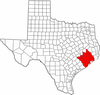 | |
|---|---|---|
| "Principal" cities | ||
| Other cities |
For a complete listing, see list of cities and towns in Houston–The Woodlands–Sugar Land MSA | |
| Unincorporated areas | ||
| Bodies of water | ||
Municipalities and communities of Fort Bend County, Texas, United States | ||
|---|---|---|
| Cities | 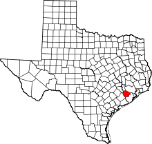 | |
| Town | ||
| Villages | ||
| CDPs | ||
| Unincorporated communities | ||
| Ghost towns | ||
| Footnotes | ‡This populated place also has portions in an adjacent county or counties;
±Former community annexed by Missouri City | |
