Hernando, Mississippi
| Hernando, Mississippi | |
|---|---|
| City | |
|
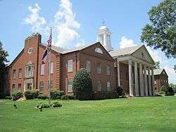
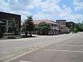
Courthouse in Hernando | |
| Motto: "Mississippi's Front Porch" | |
 Location of Hernando, Mississippi | |
 Hernando, Mississippi Location in the United States | |
| Coordinates: 34°49′51″N 89°59′37″W / 34.83083°N 89.99361°WCoordinates: 34°49′51″N 89°59′37″W / 34.83083°N 89.99361°W | |
| Country | United States |
| State | Mississippi |
| County | DeSoto |
| Established | 1839 |
| Government | |
| • Mayor | Chip Johnson (R)[1][2] |
| Area | |
| • Total | 25.8 sq mi (66.9 km2) |
| • Land | 25.7 sq mi (66.6 km2) |
| • Water | 0.1 sq mi (0.3 km2) |
| Elevation | 381 ft (116 m) |
| Population (2010) | |
| • Total | 14,090 |
| • Density | 548/sq mi (211.5/km2) |
| Time zone | Central (CST) (UTC-6) |
| • Summer (DST) | CDT (UTC-5) |
| ZIP code | 38632 |
| Area code(s) | 662 |
| FIPS code | 28-31780 |
| GNIS feature ID | 0690292 |
| Website |
www |
Hernando is a city in central DeSoto County, Mississippi, United States. The population was 14,090 at the 2010 census,[3] up from 6,812 at the 2000 census. Hernando is the county seat of DeSoto County, the second-most-populous county in the Memphis metropolitan area.[4] U.S. Route 51 and the I-55 freeway traverse the city from north to south, and the I-69 freeway crosses the city from east to west. Hernando's historic downtown square, which surrounds the county courthouse, sits at the intersection of Commerce Street and U.S. 51.
History
Hernando is named for the Spanish explorer Hernando de Soto, discoverer of the Mississippi River.[5]
Geography
Hernando is in the center of DeSoto County, bordered to the north by the city of Southaven. Via Interstate 55 or US 51, it is 25 miles (40 km) north to the center of Memphis, Tennessee, and south 15 miles (24 km) to Senatobia. According to the United States Census Bureau, the city of Hernando has a total area of 25.8 square miles (66.9 km2), of which 25.7 square miles (66.6 km2) is land, and 0.1 square miles (0.3 km2), or 0.39%, is water.[3]
Climate
The climate in this area is characterized by hot, humid summers and generally mild to cool winters. According to the Köppen Climate Classification system, Hernando has a humid subtropical climate, abbreviated "Cfa" on climate maps.[6]
Education
Hernando is served by the DeSoto County School District.
Demographics
| Historical population | |||
|---|---|---|---|
| Census | Pop. | %± | |
| 1870 | 730 | — | |
| 1880 | 583 | −20.1% | |
| 1890 | 602 | 3.3% | |
| 1900 | 563 | −6.5% | |
| 1910 | 600 | 6.6% | |
| 1920 | 796 | 32.7% | |
| 1930 | 938 | 17.8% | |
| 1940 | 1,072 | 14.3% | |
| 1950 | 1,206 | 12.5% | |
| 1960 | 1,898 | 57.4% | |
| 1970 | 2,499 | 31.7% | |
| 1980 | 2,969 | 18.8% | |
| 1990 | 3,125 | 5.3% | |
| 2000 | 6,812 | 118.0% | |
| 2010 | 14,090 | 106.8% | |
| Est. 2015 | 15,503 | [7] | 10.0% |
As of the census[9] of 2000, there were 6,812 people, 2,482 households, and 1,809 families residing in the city. The population density was 603.0 people per square mile (232.8/km²). There were 2,720 housing units at an average density of 240.8 per square mile (92.9/km²). The racial makeup of the city was 76.35% White, 21.48% African American, 0.15% Native American, 0.66% Asian, 0.78% from other races, and 0.59% from two or more races. Hispanic or Latino of any race were 3.04% of the population.
There were 2,482 households out of which 35.5% had children under the age of 18 living with them, 55.2% were married couples living together, 13.4% had a female householder with no husband present, and 27.1% were non-families. 22.9% of all households were made up of individuals and 8.5% had someone living alone who was 65 years of age or older. The average household size was 2.60 and the average family size was 3.05.
In the city the population was spread out with 25.9% under the age of 18, 9.4% from 18 to 24, 30.9% from 25 to 44, 22.0% from 45 to 64, and 11.7% who were 65 years of age or older. The median age was 34 years. For every 100 females there were 98.8 males. For every 100 females age 18 and over, there were 97.5 males.
The median income for a household in the city was $43,217, and the median income for a family was $51,155. Males had a median income of $39,706 versus $25,685 for females. The per capita income for the city was $20,731. About 6.5% of families and 9.8% of the population were below the poverty line, including 12.2% of those under age 18 and 16.3% of those age 65 or over.
Gallery


 Court Square
Notable people
- Garfield Akers, blues musician
- George "Mojo" Buford, blues musician
- Louis Bullard, football player
- Paul Burlison, musician and member of The Rock and Roll Trio
- Kevin Dockery, professional football player
- Nathan Bedford Forrest, Confederate general in the American Civil War
- Marshall Grant, Johnny Cash's former bass player
- Jim Jackson, blues musician
- Jerry Lee Lewis, musician; bought a large home in Hernando as an adult[10]
- Bradley Sowell, offensive tackle for the Arizona Cardinals
- Garrison Starr, singer/songwriter
- Frank Stokes, blues musician
- Robert Wilkins, blues musician
- Ricky Robertson, track and field high jumper, 2016 Olympian, 10 time NCAA All-American at Ole Miss
References
- ↑ Bailey, Henry (24 June 2012). "Hernando Mayor Chip Johnson stepping up to lead Mississippi Municipal Lead". The Commercial Appeal. Retrieved 3 February 2016.
Position: Mayor of Hernando, elected 2005 as Republican
- ↑ "Mayor of Hernando". City of Hernando, MS. Retrieved 3 February 2016.
- 1 2 "Geographic Identifiers: 2010 Demographic Profile Data (G001): Hernando city, Mississippi". U.S. Census Bureau, American Factfinder. Retrieved October 30, 2015.
- ↑ "Find a County". National Association of Counties. Retrieved 2011-06-07.
- ↑ Gannett, Henry (1905). The Origin of Certain Place Names in the United States. Govt. Print. Off. p. 155.
- ↑ Climate Summary for Hernando, Mississippi
- ↑ "Annual Estimates of the Resident Population for Incorporated Places: April 1, 2010 to July 1, 2015". Retrieved July 2, 2016.
- ↑ "Census of Population and Housing". Census.gov. Retrieved June 4, 2015.
- ↑ "American FactFinder". United States Census Bureau. Retrieved 2008-01-31.
- ↑ "Jerry Lee Lewis' Divorce Puts an End to Tours of Mississippi Home". Times-News. August 14, 2005.
External links
| Wikimedia Commons has media related to Hernando, Mississippi. |
.svg.png)
Municipalities and communities of DeSoto County, Mississippi, United States | ||
|---|---|---|
| Cities | 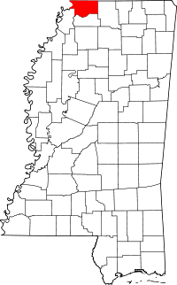 | |
| Town | ||
| CDPs | ||
| Other communities | ||