Lynchburg, Mississippi
| Lynchburg, Mississippi | |
|---|---|
| Census-designated place | |
 Location of Lynchburg, Mississippi | |
 Lynchburg, Mississippi Location in the United States | |
| Coordinates: 34°57′57″N 90°6′10″W / 34.96583°N 90.10278°WCoordinates: 34°57′57″N 90°6′10″W / 34.96583°N 90.10278°W | |
| Country | United States |
| State | Mississippi |
| County | DeSoto |
| Area | |
| • Total | 1.97 sq mi (5.10 km2) |
| • Land | 1.93 sq mi (5.01 km2) |
| • Water | 0.03 sq mi (0.09 km2) |
| Elevation | 302 ft (92 m) |
| Population (2010) | |
| • Total | 2,437 |
| • Density | 1,260/sq mi (486.5/km2) |
| Time zone | Central (CST) (UTC-6) |
| • Summer (DST) | CDT (UTC-5) |
| FIPS code | 28-42840 |
| GNIS feature ID | 0692028 |
Lynchburg is an unincorporated area and census-designated place (CDP) in DeSoto County, Mississippi. The population was 2,437 at the 2010 census.[1]
Geography
Lynchburg is located in northwestern DeSoto County at 34°57′57″N 90°6′10″W / 34.96583°N 90.10278°W (34.965750, -90.102908).[2] It is bordered to the east by the city of Horn Lake.
According to the United States Census Bureau, the Lynchburg CDP has a total area of 2.0 square miles (5.1 km2), of which 1.9 square miles (5.0 km2) is land and 0.04 square miles (0.1 km2), or 1.80%, is water.[1] The area of the CDP decreased from 3.5 square miles (9.1 km2) at the 2000 census due to annexation of the eastern part of the CDP by the city of Horn Lake.
Demographics
As of the census[3] of 2000, there were 2,959 people, 1,037 households, and 850 families residing in the CDP. The population density was 859.9 people per square mile (332.1/km²). There were 1,087 housing units at an average density of 315.9/sq mi (122.0/km²). The racial makeup of the CDP was 93.17% White, 1.99% African American, 0.34% Native American, 1.05% Asian, 0.10% Pacific Islander, 2.91% from other races, and 0.44% from two or more races. Hispanic or Latino of any race were 4.12% of the population.
There were 1,037 households out of which 41.0% had children under the age of 18 living with them, 67.4% were married couples living together, 9.4% had a female householder with no husband present, and 18.0% were non-families. 13.5% of all households were made up of individuals and 3.4% had someone living alone who was 65 years of age or older. The average household size was 2.85 and the average family size was 3.11.
In the CDP the population was spread out with 28.1% under the age of 18, 8.1% from 18 to 24, 34.9% from 25 to 44, 22.1% from 45 to 64, and 6.8% who were 65 years of age or older. The median age was 33 years. For every 100 females there were 101.8 males. For every 100 females age 18 and over, there were 99.7 males.
The median income for a household in the CDP was $54,714, and the median income for a family was $61,495. Males had a median income of $41,586 versus $25,332 for females. The per capita income for the CDP was $20,455. About 5.9% of families and 9.0% of the population were below the poverty line, including 10.1% of those under age 18 and 8.9% of those age 65 or over.
Education
Lynchburg is served by the DeSoto County School District.
References
- 1 2 "Geographic Identifiers: 2010 Demographic Profile Data (G001): Lynchburg CDP, Mississippi". U.S. Census Bureau, American Factfinder. Retrieved November 2, 2015.
- ↑ "US Gazetteer files: 2010, 2000, and 1990". United States Census Bureau. 2011-02-12. Retrieved 2011-04-23.
- ↑ "American FactFinder". United States Census Bureau. Retrieved 2008-01-31.
Municipalities and communities of DeSoto County, Mississippi, United States | ||
|---|---|---|
| Cities | 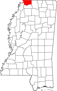 | |
| Town | ||
| CDPs | ||
| Other communities | ||