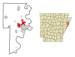
Marion, Arkansas
| Marion, Arkansas | |
|---|---|
| City | |
|
Crittenden County Courthouse | |
 Location in Crittenden County and the state of Arkansas | |
| Coordinates: 35°12′22″N 90°12′6″W / 35.20611°N 90.20167°WCoordinates: 35°12′22″N 90°12′6″W / 35.20611°N 90.20167°W | |
| Country | United States |
| State | Arkansas |
| County | Crittenden |
| Area | |
| • Total | 20.5 sq mi (53.1 km2) |
| • Land | 20.4 sq mi (52.9 km2) |
| • Water | 0.08 sq mi (0.2 km2) |
| Elevation | 226 ft (69 m) |
| Population (2010) | |
| • Total | 12,345 |
| • Density | 605/sq mi (233.4/km2) |
| Time zone | Central (CST) (UTC-6) |
| • Summer (DST) | CDT (UTC-5) |
| ZIP code | 72364 |
| Area code(s) | 870 |
| FIPS code | 05-44180 |
| GNIS feature ID | 0077597 |
| Website |
www |

Marion is a city in and the county seat of Crittenden County, Arkansas, United States. The population was 12,345 at the 2010 census, a 38.7% increase since 2000.[1] The city is part of the Memphis metropolitan area. It is the second largest city in Crittenden County, behind West Memphis.
History
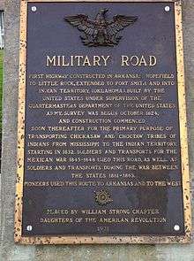
Although Marion was incorporated in 1896, the community predates that significantly. The site of Marion was part of Louisiana (New Spain) from 1764 to 1803, when it became Louisiana (New France). Some of the oldest land titles in the area are from Spanish land grants from a time prior to the Louisiana Purchase.[2] After the Louisiana Purchase the area was part of the Arkansas Territory. During the 1830s the Trail of Tears, the forced removal of Native Americans from Georgia, Alabama, and Mississippi, passed through the area.[3][4] Its location is close to where the Sultana Steamboat exploded and sunk. A memorial is placed on the city hall square to remember those lost in the accident
Marion, AR was named after Marion Tolbert. In 1837 two commissioners had been appointed by the county court to select a site for a new county seat. Tolbert and his wife Temperance gave a deed to the commissioners "for the county of Crittenden for county purposes" on June 25th, 1837. A town was laid out, named Marion in honor of Marion Tolbert and was made the county seat of Crittenden County, AR..[5] Marion has been incorporated on multiple occasions, first in 1851. The current incorporation dates from 1896.
During the American Civil War the steamboat Sultana was destroyed in an explosion on April 27, 1865, as it was transporting released Union POWs near Mound City, just east of Marion. It is estimated that 1,500 soldiers and crew were killed, the largest loss of life in a maritime accident in US history. This tragedy is commemorated by a historic marker placed by the Daughters of the American Revolution.
Geography
Marion is located in eastern Crittenden County at 35°12′22″N 90°12′6″W / 35.20611°N 90.20167°W (35.206092, -90.201734).[6] It is bordered by the city of West Memphis to the south and by Sunset and Clarkedale to the north.
According to the United States Census Bureau, Marion has a total area of 20.5 square miles (53.1 km2), of which 20.4 square miles (52.9 km2) is land and 0.077 square miles (0.2 km2), or 0.37%, is water.[7]
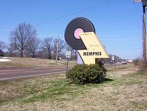
Marion is 11 miles (18 km) west of Memphis, Tennessee, and has a humid subtropical climate.
| Climate data for Memphis (Memphis Int'l), 1981−2010 normals, extremes 1872−present[8] | |||||||||||||
|---|---|---|---|---|---|---|---|---|---|---|---|---|---|
| Month | Jan | Feb | Mar | Apr | May | Jun | Jul | Aug | Sep | Oct | Nov | Dec | Year |
| Record high °F (°C) | 79 (26) |
81 (27) |
87 (31) |
94 (34) |
99 (37) |
104 (40) |
108 (42) |
107 (42) |
103 (39) |
95 (35) |
86 (30) |
81 (27) |
108 (42) |
| Average high °F (°C) | 49.8 (9.9) |
54.7 (12.6) |
63.9 (17.7) |
73.0 (22.8) |
81.2 (27.3) |
88.9 (31.6) |
91.6 (33.1) |
91.3 (32.9) |
85.1 (29.5) |
74.4 (23.6) |
62.6 (17) |
52.1 (11.2) |
72.4 (22.4) |
| Daily mean °F (°C) | 41.2 (5.1) |
45.5 (7.5) |
54.0 (12.2) |
62.9 (17.2) |
71.7 (22.1) |
79.6 (26.4) |
82.7 (28.2) |
82.0 (27.8) |
75.2 (24) |
64.1 (17.8) |
53.2 (11.8) |
43.6 (6.4) |
63.0 (17.2) |
| Average low °F (°C) | 32.6 (0.3) |
36.3 (2.4) |
44.1 (6.7) |
52.9 (11.6) |
62.2 (16.8) |
70.3 (21.3) |
73.8 (23.2) |
72.7 (22.6) |
65.2 (18.4) |
53.8 (12.1) |
43.7 (6.5) |
35.1 (1.7) |
53.6 (12) |
| Record low °F (°C) | −8 (−22) |
−11 (−24) |
12 (−11) |
27 (−3) |
36 (2) |
48 (9) |
52 (11) |
48 (9) |
36 (2) |
25 (−4) |
9 (−13) |
−13 (−25) |
−13 (−25) |
| Average precipitation inches (mm) | 3.98 (101.1) |
4.39 (111.5) |
5.16 (131.1) |
5.50 (139.7) |
5.25 (133.4) |
3.63 (92.2) |
4.59 (116.6) |
2.88 (73.2) |
3.09 (78.5) |
3.98 (101.1) |
5.49 (139.4) |
5.74 (145.8) |
53.68 (1,363.5) |
| Average snowfall inches (cm) | 1.9 (4.8) |
1.3 (3.3) |
0.4 (1) |
0 (0) |
0 (0) |
0 (0) |
0 (0) |
0 (0) |
0 (0) |
0 (0) |
trace | 0.2 (0.5) |
3.8 (9.7) |
| Average precipitation days (≥ 0.01 in) | 9.5 | 9.2 | 10.5 | 9.6 | 10.3 | 9.0 | 8.8 | 6.8 | 7.3 | 7.5 | 9.5 | 9.7 | 107.7 |
| Average snowy days (≥ 0.1 in) | 1.2 | 0.8 | 0.4 | 0 | 0 | 0 | 0 | 0 | 0 | 0 | 0 | 0.4 | 2.8 |
| Average relative humidity (%) | 68.2 | 66.4 | 63.2 | 62.5 | 66.4 | 66.8 | 69.1 | 69.6 | 71.3 | 66.2 | 67.7 | 68.8 | 67.2 |
| Mean monthly sunshine hours | 166.6 | 173.8 | 215.3 | 254.6 | 301.5 | 320.6 | 326.9 | 307.0 | 251.2 | 245.9 | 173.0 | 151.9 | 2,888.3 |
| Percent possible sunshine | 53 | 57 | 58 | 65 | 69 | 74 | 74 | 74 | 68 | 70 | 56 | 50 | 65 |
| Source: NOAA (relative humidity 1961−1990, sun 1961−1987)[9][10][11][12][13] | |||||||||||||
Transportation
Major highways
Marion is bisected by Interstate 55 and is located just to the north of its junction with Interstate 40 prior to their crossing the Mississippi River, en route to Memphis. U.S. Highway 64 is the major east-west route through the town. Arkansas Highway 77 is a major north-south arterial road, east of Interstate 55, and Highway 118 is the major north-south arterial road, west of Interstate 55.
Aviation
Marion is served for general aviation by the West Memphis Municipal Airport (KAWM).[14] General DeWitt Spain Airport is a civil aviation airport just north of downtown Memphis. Memphis International Airport is located south of Memphis; it provides commercial aviation through numerous carriers and is the international cargo hub for FedEx.
Rail
Union Pacific operates a 600-acre (240 ha) intermodal facility west of Marion.[15] BNSF Railway also operates an intermodal yard in Marion.
Limited passenger rail is available on Amtrak at Central Station in nearby Memphis. The City of New Orleans runs twice daily on a north-south route from Chicago to New Orleans.[16]
Water
Crittenden County and West Memphis jointly operate a port on the Mississippi River.[17] The International Port of Memphis lies just across the Mississippi River via Interstate 55. The International Port of Memphis is the fourth-largest inland port in the United States.[18]
Community
Because of its proximity to Memphis and Interstate highways, Marion offers the activities and enrichment of a large city while maintaining the character of a small community. In addition to the many community events common to any town, each May Marion hosts the Esperanza Bonanza, a festival that includes live music, a barbecue competition, a rodeo, a golf tournament, a carnival, and games for adults & children.[19] More recently Marion has begun "Christmas on the Square" in early December co-sponsored by the local Kiwanis Club and the Marion Chamber of Commerce.[20]
Marion is served by the Woolfolk Public Library[21] which is jointly operated by Crittenden County and the city of Marion. It was named in honor of a local author and newspaper editor, Margaret Woolfolk.
Outdoor recreation is a big part of community life, from organized youth sports to individual and family activities. Marion is located less than 1 hour from 12 Arkansas, Tennessee or Mississippi state parks.[22] Additional outdoor recreation is available at Wapanocca National Wildlife Refuge about 10 miles (16 km) north of town. The nearby community of Horseshoe Lake offers opportunity for water sports.
Healthcare
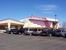
Since 1951 Marion and Crittenden County have been served by Crittenden Regional Hospital[23] a 152-bed JCAHO Accredited facility [24] in nearby West Memphis. The hospital was closed in 2014 and is in the process of attempting to reopen under new ownership.
Demographics
| Historical population | |||
|---|---|---|---|
| Census | Pop. | %± | |
| 1880 | 199 | — | |
| 1940 | 758 | — | |
| 1950 | 883 | 16.5% | |
| 1960 | 881 | −0.2% | |
| 1970 | 1,431 | 62.4% | |
| 1980 | 2,996 | 109.4% | |
| 1990 | 4,391 | 46.6% | |
| 2000 | 8,901 | 102.7% | |
| 2010 | 12,345 | 38.7% | |
| Est. 2015 | 12,292 | [25] | −0.4% |
2010 Census [1]
As of the census[27] of 2010, there were 12,345 people and 4,278 households in the city. The population density was 604.4 people per square mile (256.1/km²). The racial makeup of the city was 68.1% White, 28% Black or African American, 0.4% Native American, 1.5% Asian, 1.4% from two or more races. 2.0% of the population were Hispanic or Latino of any race.
88% of the population had a high school diploma and 28% reported a bachelor's degree or higher. 2.5 of the population is foreign born and 4.4% report a language other than English being spoken at home. The home ownership rate was 71.3% at a median value of $142,200. The median household income was $60,051. 7.3% of the population are below the poverty line.
Education
Crittenden County is served by Mid-South Community College in West Memphis. The college offers bachelor's and master's degree programs in conjunction with Arkansas State University, the University of Arkansas, the University of Central Arkansas, Arkansas Tech University and Franklin University.[28]
Public schools
- Avondale Elementary School (grades pre-k through 1st grade)
- Marion Elementary School (grades 2nd through 3rd)
- Marion Intermediate School (grades 4 through 5)
- Marion Middle School (grades 6 though 7)
- Marion Jr. High School (grades 8 through 9)
- Marion High School (grades 10-12)
Private schools
- West Memphis Christian School, PK-12 (West Memphis)
- Crittenden Pentecostal Academy, K-12 (West Memphis)
- St. Michael's Catholic School, PK-6 (West Memphis)
Notable people
- Milton Nicks (born c. 1950), Democratic member of the Arkansas House of Representatives for Crittenden and Cross counties since 2015; Baptist pastor in his native Earle, Arkansas, resident of Marion[29]
Notes
References
| Wikimedia Commons has media related to Marion, Arkansas. |
- 1 2 http://quickfacts.census.gov/qfd/states/05/0544180.html
- ↑ http://marionar.org/visit-marion/historic-locations/area-history/
- ↑ http://www.nps.gov/history/NR/twhp/wwwlps/lessons/118trail/118locate2.htm
- ↑ http://www.arkansasheritagetrails.com/Tears/
- ↑ Biographical and Historical Memoirs of Eastern Arkansas, Goodspeed Publisching, 1890, page 391
- ↑ "US Gazetteer files: 2010, 2000, and 1990". United States Census Bureau. 2011-02-12. Retrieved 2011-04-23.
- ↑ "Geographic Identifiers: 2010 Demographic Profile Data (G001): Marion city, Arkansas". U.S. Census Bureau, American Factfinder. Retrieved June 19, 2014.
- ↑ Official records for Memphis were kept at downtown from January 1872 to December 1939 and at Memphis Int'l since January 1940.NCDC-NOAA (2015). "ThreadEx [Long-Term Station Extremes for America], Version 10.1, released 2 April 2015". Ithaca, NY, USA: Northeast Regional Climate Center (NRCC, Keith Eggleston) and National Oceanic and Atmospheric Administration (NOAA, Bryant Korzeniewski). Retrieved 2 December 2015.
- ↑ "NowData – NOAA Online Weather Data". National Oceanic and Atmospheric Administration. Retrieved 2014-05-13.
- ↑ "Climate Normals and Records - National Weather Service Memphis, TN". National Weather Service. Retrieved 2012-01-09.
- ↑ "Station Name: TN MEMPHIS INTL AP". National Oceanic & Atmospheric Administration. Retrieved 2014-03-28.
- ↑ "WMO Climate Normals for MEMPHIS/WSCMO AP TN 1961–1990". National Oceanic and Atmospheric Administration. Retrieved 2014-03-10.
- ↑ "Average Percent Sunshine through 2009". National Climatic Data Center. Retrieved 2012-11-16.
- ↑ http://www.ci.west-memphis.ar.us/airport.htm
- ↑ http://www.uprr.com/aboutup/usguide/attachments/state_factsheets/ar.pdf
- ↑ http://www.amtrak.com/servlet/ContentServer?c=AM_Route_C&pagename=am%2FLayout&cid=1241245653236
- ↑ http://westmemphis.com/industrial-sites/better-access/river
- ↑ http://www.portofmemphis.com/about.asp
- ↑ http://www.esperanzabonanza.org/
- ↑ http://marionar.org/visit-marion/what-to-do/
- ↑ http://www.facebook.com/Woolfolk.Public.Library?sk=wall
- ↑ http://www.marionarkansas.org/economic/eco002_about.htm
- ↑ http://www.crittendenregional.org/
- ↑ http://www.qualitycheck.org/qualityreport.aspx?hcoid=8687
- ↑ "Annual Estimates of the Resident Population for Incorporated Places: April 1, 2010 to July 1, 2015". Retrieved July 2, 2016.
- ↑ "Census of Population and Housing". Census.gov. Retrieved June 4, 2015.
- ↑ "American FactFinder". United States Census Bureau. Retrieved 2008-01-31.
- ↑ http://www.midsouthcc.edu/index.php?id=55
- ↑ "Milton Nicks, Jr.'s Biography". Project Vote Smart. Retrieved April 14, 2015.
External links
- City of Marion official website
- Marion Chamber of Commerce
- Crittenden County
- "Marion" entry, Arkansas Encyclopedia of History and Culture
Municipalities and communities of Crittenden County, Arkansas, United States | ||
|---|---|---|
| Cities |  | |
| Towns | ||
| Unincorporated communities |
| |