Butler, Indiana
| Butler, Indiana | |
|---|---|
| City | |
 Location in the state of Indiana | |
| Coordinates: 41°25′49″N 84°52′19″W / 41.43028°N 84.87194°WCoordinates: 41°25′49″N 84°52′19″W / 41.43028°N 84.87194°W | |
| Country | United States |
| State | Indiana |
| County | DeKalb |
| Government | |
| • Mayor | Ron Walter (R) |
| Area[1] | |
| • Total | 2.09 sq mi (5.41 km2) |
| • Land | 2.09 sq mi (5.41 km2) |
| • Water | 0 sq mi (0 km2) |
| Elevation | 866 ft (264 m) |
| Population (2010)[2] | |
| • Total | 2,684 |
| • Estimate (2012[3]) | 2,687 |
| • Density | 1,284.2/sq mi (495.8/km2) |
| Time zone | EST (UTC-5) |
| • Summer (DST) | EDT (UTC-4) |
| ZIP code | 46721 |
| Area code(s) | 260 |
| FIPS code | 18-09532[4] |
| GNIS feature ID | 0431897[5] |
| Website | http://www.butler.in.us |
Butler is a city in DeKalb County, Indiana, United States. The population was 2,684 at the 2010 census.
History
Butler was platted in 1856 when the railroad was extended to that point.[6] It was likely named for David Butler, a pioneer.[7] Butler was incorporated in as a town 1866, and as a city in 1903.[8]
The Downtown Butler Historic District was added to the National Register of Historic Places in 2001.[9]
Geography
Butler is located at 41°25′49″N 84°52′19″W / 41.430166°N 84.871859°W.[10]
According to the 2010 census, Butler has a total area of 2.09 square miles (5.41 km2), all land.[1]
Demographics
| Historical population | |||
|---|---|---|---|
| Census | Pop. | %± | |
| 1880 | 1,056 | — | |
| 1890 | 2,521 | 138.7% | |
| 1900 | 2,063 | −18.2% | |
| 1910 | 1,818 | −11.9% | |
| 1920 | 1,745 | −4.0% | |
| 1930 | 1,643 | −5.8% | |
| 1940 | 1,794 | 9.2% | |
| 1950 | 1,914 | 6.7% | |
| 1960 | 2,176 | 13.7% | |
| 1970 | 2,394 | 10.0% | |
| 1980 | 2,509 | 4.8% | |
| 1990 | 2,601 | 3.7% | |
| 2000 | 2,725 | 4.8% | |
| 2010 | 2,684 | −1.5% | |
| Est. 2015 | 2,701 | [11] | 0.6% |
2010 census
As of the census[2] of 2010, there were 2,684 people, 951 households, and 668 families residing in the city. The population density was 1,284.2 inhabitants per square mile (495.8/km2). There were 1,089 housing units at an average density of 521.1 per square mile (201.2/km2). The racial makeup of the city was 94.9% White, 0.5% African American, 0.4% Native American, 0.2% Asian, 2.3% from other races, and 1.8% from two or more races. Hispanic or Latino of any race were 4.3% of the population.
There were 951 households of which 43.0% had children under the age of 18 living with them, 44.8% were married couples living together, 15.7% had a female householder with no husband present, 9.8% had a male householder with no wife present, and 29.8% were non-families. 24.4% of all households were made up of individuals and 7.8% had someone living alone who was 65 years of age or older. The average household size was 2.71 and the average family size was 3.17.
The median age in the city was 33.7 years. 29.3% of residents were under the age of 18; 8.9% were between the ages of 18 and 24; 27.1% were from 25 to 44; 22.7% were from 45 to 64; and 11.9% were 65 years of age or older. The gender makeup of the city was 49.9% male and 50.1% female.
2000 census
As of the census[4] of 2000, there were 2,725 people, 983 households, and 699 families residing in the city. The population density was 1,523.6 people per square mile (587.8/km²). There were 1,075 housing units at an average density of 601.1 per square mile (231.9/km²). The racial makeup of the city was 97.69% White, 0.15% African American, 0.18% Native American, 0.11% Asian, 1.25% from other races, and 0.62% from two or more races. Hispanic or Latino of any race were 2.24% of the population.
There were 983 households out of which 40.5% had children under the age of 18 living with them, 53.8% were married couples living together, 12.1% had a female householder with no husband present, and 28.8% were non-families. 23.6% of all households were made up of individuals and 8.1% had someone living alone who was 65 years of age or older. The average household size was 2.68 and the average family size was 3.17.
In the city the population was spread out with 30.8% under the age of 18, 10.3% from 18 to 24, 30.5% from 25 to 44, 18.3% from 45 to 64, and 10.2% who were 65 years of age or older. The median age was 31 years. For every 100 females there were 94.9 males. For every 100 females age 18 and over, there were 90.2 males.
The median income for a household in the city was $37,250, and the median income for a family was $42,188. Males had a median income of $32,361 versus $21,404 for females. The per capita income for the city was $15,040. About 5.5% of families and 9.7% of the population were below the poverty line, including 11.7% of those under age 18 and 14.1% of those age 65 or over.
Government


The government consists of a mayor and a city council. The mayor is elected in citywide vote. The city council consists of five members four are elected from individual districts. One is elected at-large.
Local newspaper
The Butler Bulletin, serving eastern DeKalb County, was purchased by KPC Media Group Inc. in December 2005, from publisher Joe Shelton, who founded the newspaper in 1976. The editor is Jeff Jones, who has worked for the weekly since 1985.[13] The newspaper is published by KPC Media Group, with its website at kpcnews.com
Education
The city of Butler lies in the school district of DeKalb County Eastern Community Schools. The local schools city residents attend are:
- Butler Elementary
- Eastside Junior-Senior High School
Public library
The city of Butler is served by the Butler Public Library. The library completed an expansion and renovation project in August 2009, nearly doubling its size. The expansion included a new Children's Department and Story Time Room, a new community room, Teen Zone and Genealogy Room.
Notable people
- Jeff Berry, Ku Klux Klan leader
- Nemo Leibold, outfielder for Chicago White Sox in both the 1917 and 1919 World Series.
References
- 1 2 "G001 - Geographic Identifiers - 2010 Census Summary File 1". United States Census Bureau. Retrieved 2015-07-28.
- 1 2 "American FactFinder". United States Census Bureau. Retrieved 2012-12-11.
- ↑ "Population Estimates". United States Census Bureau. Archived from the original on 2013-06-17. Retrieved 2013-06-25.
- 1 2 "American FactFinder". United States Census Bureau. Archived from the original on 2013-09-11. Retrieved 2008-01-31.
- ↑ "US Board on Geographic Names". United States Geological Survey. 2007-10-25. Retrieved 2008-01-31.
- ↑ History of DeKalb County, Indiana: Together with Sketches of Its Cities, Villages and Towns. Inter-State Publishing Company. 1885. p. 962.
- ↑ Baker, Ronald L. (October 1995). From Needmore to Prosperity: Hoosier Place Names in Folklore and History. Indiana University Press. p. 83. ISBN 978-0-253-32866-3.
...the name probably honors David Butler, an early settler...
- ↑ History of Dekalb County, Indiana. B.F. Bowen & Co. 1914. p. 148.
- ↑ National Park Service (2010-07-09). "National Register Information System". National Register of Historic Places. National Park Service.
- ↑ "US Gazetteer files: 2010, 2000, and 1990". United States Census Bureau. 2011-02-12. Retrieved 2011-04-23.
- ↑ "Annual Estimates of the Resident Population for Incorporated Places: April 1, 2010 to July 1, 2015". Retrieved July 2, 2016.
- ↑ "Census of Population and Housing". Census.gov. Archived from the original on May 11, 2015. Retrieved June 4, 2015.
- ↑ http://www.kpcnews.com/?x=about
External links
- City of Butler, Indiana website
- Butler Public Library
- Butler Elementary
- Eastside Junior-Senior High School
- The Butler Bulletin
Municipalities and communities of DeKalb County, Indiana, United States | ||
|---|---|---|
| Cities | ||
| Towns | ||
| Townships | ||
| Unincorporated communities | ||
| Footnotes | ‡This populated place also has portions in an adjacent county or counties | |
| Counties | 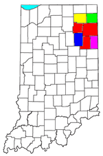 | |
|---|---|---|
| Municipalities with population over 10,000 in 2010 | ||
| Municipalities with population 1,000-10,000 in 2010 | ||
| Municipalities with population under 1,000 in 2010 | ||
| CDPs | ||