Larwill, Indiana
| Larwill, Indiana | |
|---|---|
| Town | |
|
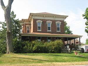
The historic Christopher Souder House | |
 Location of Larwill in the state of Indiana | |
| Coordinates: 41°10′44″N 85°37′28″W / 41.17889°N 85.62444°WCoordinates: 41°10′44″N 85°37′28″W / 41.17889°N 85.62444°W | |
| Country | United States |
| State | Indiana |
| County | Whitley |
| Township | Richland |
| Area[1] | |
| • Total | 0.22 sq mi (0.57 km2) |
| • Land | 0.22 sq mi (0.57 km2) |
| • Water | 0 sq mi (0 km2) |
| Elevation[2] | 961 ft (293 m) |
| Population (2010)[3] | |
| • Total | 283 |
| • Estimate (2012[4]) | 282 |
| • Density | 1,286.4/sq mi (496.7/km2) |
| Time zone | Eastern (EST) (UTC-5) |
| • Summer (DST) | EDT (UTC-4) |
| ZIP code | 46764 |
| Area code(s) | 260 |
| FIPS code | 18-42282[5] |
| GNIS feature ID | 437635 |
Larwill is a town in Richland Township, Whitley County, Indiana, United States.[6] The population was 283 at the 2010 census.
History
Larwill was named after William and Joseph Larwill, who were railroad engineers.[7]
The Larwill post office has been in operation since 1866.[8]
The Dr. Christopher Souder House was listed on the National Register of Historic Places in 2005.[9]
Geography
Larwill is located at 41°10′44″N 85°37′28″W / 41.17889°N 85.62444°W (41.178932, -85.624357).[10]
According to the 2010 census, Larwill has a total area of 0.22 square miles (0.57 km2), all land.[1]
Demographics
| Historical population | |||
|---|---|---|---|
| Census | Pop. | %± | |
| 1880 | 506 | — | |
| 1920 | 264 | — | |
| 1930 | 252 | −4.5% | |
| 1940 | 319 | 26.6% | |
| 1950 | 316 | −0.9% | |
| 1960 | 994 | 214.6% | |
| 1970 | 324 | −67.4% | |
| 1980 | 286 | −11.7% | |
| 1990 | 219 | −23.4% | |
| 2000 | 282 | 28.8% | |
| 2010 | 283 | 0.4% | |
| Est. 2015 | 282 | [11] | −0.4% |
2010 census
As of the census[3] of 2010, there were 283 people, 100 households, and 69 families residing in the town. The population density was 1,286.4 inhabitants per square mile (496.7/km2). There were 125 housing units at an average density of 568.2 per square mile (219.4/km2). The racial makeup of the town was 98.9% Non-Hispanic White and 1.1% from two or more races. There were 100 households of which 33.0% had children under the age of 18 living with them, 41.0% were married couples living together, 16.0% had a female householder with no husband present, 12.0% had a male householder with no wife present, and 31.0% were non-families. 26.0% of all households were made up of individuals and 13% had someone living alone who was 65 years of age or older. The average household size was 2.83 and the average family size was 3.36.
The median age in the town was 35.5 years. 26.1% of residents were under the age of 18; 12% were between the ages of 18 and 24; 23.3% were from 25 to 44; 27.6% were from 45 to 64; and 11% were 65 years of age or older. The gender makeup of the town was 49.1% male and 50.9% female.
2000 census
As of the census[5] of 2000, there were 282 people, 98 households, and 70 families residing in the town. The population density was 1,266.9 people per square mile (494.9/km²). There were 106 housing units at an average density of 476.2 per square mile (186.0/km²). The racial makeup of the town was 98.94% White, 0.35% Asian, and 0.71% from two or more races.
There were 98 households out of which 40.8% had children under the age of 18 living with them, 53.1% were married couples living together, 14.3% had a female householder with no husband present, and 27.6% were non-families. 24.5% of all households were made up of individuals and 10.2% had someone living alone who was 65 years of age or older. The average household size was 2.88 and the average family size was 3.45.
In the town the population was spread out with 34.8% under the age of 18, 8.2% from 18 to 24, 32.3% from 25 to 44, 13.5% from 45 to 64, and 11.3% who were 65 years of age or older. The median age was 30 years. For every 100 females there were 102.9 males. For every 100 females age 18 and over, there were 97.8 males.
The median income for a household in the town was $36,563, and the median income for a family was $40,556. Males had a median income of $29,167 versus $19,688 for females. The per capita income for the town was $13,154. About 13.2% of families and 10.7% of the population were below the poverty line, including 12.5% of those under the age of eighteen and 9.7% of those sixty five or over.
Notable natives
- Jill Long Thompson, former U.S. Representative, former candidate for Governor of Indiana
References
- 1 2 "G001 - Geographic Identifiers - 2010 Census Summary File 1". United States Census Bureau. Retrieved 2015-07-17.
- ↑ "US Board on Geographic Names". United States Geological Survey. October 25, 2007. Retrieved 2016-07-06.
- 1 2 "American FactFinder". United States Census Bureau. Retrieved 2012-12-11.
- ↑ "Population Estimates". United States Census Bureau. Retrieved 2013-06-25.
- 1 2 "American FactFinder". United States Census Bureau. Retrieved 2008-01-31.
- ↑ "Larwill, Indiana". Geographic Names Information System. United States Geological Survey. Retrieved 2016-07-06.
- ↑ "Profile for Larwill, IN". ePodunk. Retrieved 6 July 2016.
- ↑ "Whitley County". Jim Forte Postal History. Retrieved 6 July 2016.
- ↑ National Park Service (2010-07-09). "National Register Information System". National Register of Historic Places. National Park Service.
- ↑ "US Gazetteer files: 2010, 2000, and 1990". United States Census Bureau. 2011-02-12. Retrieved 2011-04-23.
- ↑ "Annual Estimates of the Resident Population for Incorporated Places: April 1, 2010 to July 1, 2015". Retrieved July 2, 2016.
- ↑ "Census of Population and Housing". Census.gov. Retrieved June 4, 2015.
Municipalities and communities of Whitley County, Indiana, United States | ||
|---|---|---|
| City | ||
| Towns | ||
| Townships | ||
| CDP | ||
| Other unincorporated communities | ||
| Footnotes | ‡This populated place also has portions in an adjacent county or counties | |
| Counties | 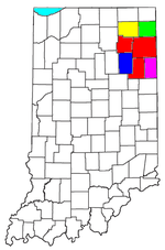 | |
|---|---|---|
| Municipalities with population over 10,000 in 2010 | ||
| Municipalities with population 1,000-10,000 in 2010 | ||
| Municipalities with population under 1,000 in 2010 | ||
| CDPs | ||