Churubusco, Indiana
| Town of Churubusco, Indiana | |
|---|---|
| Town | |
|
Turtle Town, U.S.A. | |
| Nickname(s): 'Busco, Turtle Town, U.S.A. | |
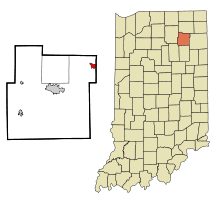 Location in the state of Indiana | |
 City limits as of 2010 annexation. | |
| Coordinates: 41°13′53″N 85°19′10″W / 41.23139°N 85.31944°WCoordinates: 41°13′53″N 85°19′10″W / 41.23139°N 85.31944°W | |
| Country | United States |
| State | Indiana |
| County | Whitley |
| Township | Smith |
| Government | |
| • Type | council-clerk |
| • President | Frank Kessler |
| Area[1] | |
| • Total | 0.90 sq mi (2.33 km2) |
| • Land | 0.90 sq mi (2.33 km2) |
| • Water | 0 sq mi (0 km2) |
| Elevation[2] | 899 ft (274 m) |
| Population (2010)[3] | |
| • Total | 1,796 |
| • Estimate (2012[4]) | 1,802 |
| • Density | 1,995.6/sq mi (770.5/km2) |
| • Demonym | Busconian |
| Time zone | EST (UTC−5) |
| • Summer (DST) | EDT (UTC−4) |
| ZIP code | 46723 |
| Area code(s) | 260 |
| FIPS code | 18-12610[5] |
| GNIS feature ID | 432516 |
| Website | http://www.townofchurubusco.com |

Churubusco (/ˌtʃɛrəˈbʌskoʊ/ or /ˌtʃɛriˈbʌsɡoʊ/); often shortened to Busco /ˈbʌskoʊ/), is a town located near the headwaters of the Eel River in the extreme northeast corner of Whitley County, Indiana, United States, in Smith Township, about 16 miles (26 km) northwest of Fort Wayne.[6] The population was 1,796 at the 2010 census.
Geography
According to the 2010 census, Churubusco has a total area of 0.9 square miles (2.33 km2), all land.[1]
Demographics
| Historical population | |||
|---|---|---|---|
| Census | Pop. | %± | |
| 1880 | 720 | — | |
| 1890 | 869 | 20.7% | |
| 1900 | 884 | 1.7% | |
| 1910 | 870 | −1.6% | |
| 1920 | 916 | 5.3% | |
| 1930 | 1,095 | 19.5% | |
| 1940 | 1,122 | 2.5% | |
| 1950 | 1,232 | 9.8% | |
| 1960 | 1,284 | 4.2% | |
| 1970 | 1,528 | 19.0% | |
| 1980 | 1,638 | 7.2% | |
| 1990 | 1,781 | 8.7% | |
| 2000 | 1,666 | −6.5% | |
| 2010 | 1,796 | 7.8% | |
| Est. 2015 | 1,795 | [7] | −0.1% |
2010 census
As of the census[3] of 2010, there were 1,796 people, 706 households, and 483 families residing in the town. The population density was 1,995.6 inhabitants per square mile (770.5/km2). There were 749 housing units at an average density of 832.2 per square mile (321.3/km2). The racial makeup of the town was 97.8% White, 0.1% African American, 0.3% Native American, 0.2% Asian, 0.4% from other races, and 1.2% from two or more races. Hispanic or Latino of any race were 2.1% of the population.
There were 706 households of which 37.8% had children under the age of 18 living with them, 49.4% were married couples living together, 14.4% had a female householder with no husband present, 4.5% had a male householder with no wife present, and 31.6% were non-families. 26.5% of all households were made up of individuals and 10.5% had someone living alone who was 65 years of age or older. The average household size was 2.54 and the average family size was 3.06.
The median age in the town was 33.9 years. 27.1% of residents were under the age of 18; 9.4% were between the ages of 18 and 24; 27.7% were from 25 to 44; 24.1% were from 45 to 64; and 11.7% were 65 years of age or older. The gender makeup of the town was 48.3% male and 51.7% female.
2000 census
As of the census[5] of 2000, there were 1,666 people, 650 households, and 438 families residing in the town. The population density was 1,876.8 people per square mile (722.7/km²). There were 692 housing units at an average density of 779.5 per square mile (300.2/km²). The racial makeup of the town was 97.60% White, 0.06% African American, 0.60% Native American, 0.24% Asian, 0.06% Pacific Islander, 0.12% from other races, and 1.32% from two or more races. Hispanic or Latino of any race were 1.38% of the population.
There were 650 households out of which 36.0% had children under the age of 18 living with them, 50.9% were married couples living together, 13.1% had a female householder with no husband present, and 32.5% were non-families. 28.6% of all households were made up of individuals and 13.8% had someone living alone who was 65 years of age or older. The average household size was 2.54 and the average family size was 3.15.
In the town the population was spread out with 29.0% under the age of 18, 9.7% from 18 to 24, 30.4% from 25 to 44, 18.6% from 45 to 64, and 12.3% who were 65 years of age or older. The median age was 33 years. For every 100 females there were 88.9 males. For every 100 females age 18 and over, there were 83.1 males.
The median income for a household in the town was $39,583, and the median income for a family was $49,279. Males had a median income of $34,844 versus $22,161 for females. The per capita income for the town was $17,814. About 3.2% of families and 4.9% of the population were below the poverty line, including 4.0% of those under age 18 and 7.4% of those age 65 or over.
History

Originally, the area of Churubusco was made up of two towns founded in the 19th century by European Americans: Union (in honor of the union victory of the Civil War) and Franklin (in honor of the founding father, Benjamin Franklin) that bordered each other across a railroad track. In the 1840s, the populations of both Franklin and Union grew large enough to qualify each for a post office. Before that time, residents of both towns had to trek 11 miles by foot or horse and buggy to nearby Columbia City to get their mail. Since the towns were in the same location, the Postmaster General ordered the towns to apply for a joint post office. The Postmaster General denied the use of either "Union" and "Franklin" as the new post office name, since both were already used by other Indiana towns.
After a community meeting, the residents selected Churubusco for the new post office, named after the site of the 1847 Battle of Churubusco, in Mexico during the Mexican-American War. At the time, after the suggestion of local school teacher Eliza Rich, the townsfolk thought it was as patriotic a name as Union and Franklin, since the United States won a large victory there. More importantly, they were certain no other Indiana town would already have chosen such a unique name.[9] The Churubusco post office has been in operation since 1848.[10]
The name Churubusco is a Spanish corruption of an indigenous Nahuatl toponym (place name) referring to a temple area celebrating the Aztec god Huitzilopochtli. It is bordered by the Rio Churubusco in Mexico City. The Spanish-Nahuatl word literally translates as "place of the hummingbirds.[11]
Law and government
Churubusco has an elected clerk and town council-style government. The Churubusco Town Council is a three-member legislative group that serve four-year terms; each are elected town-wide as at-large council members. The council elects one member from among its body to act a president of the council. That president sets agendas during council meetings. The current council members were elected on November 3, 2015. Beginning January 1, 2016, the Council will begin serving staggered terms, with two members (Kessler & Johnson) serving a one-time, three-year term, expiring December 31, 2018, and one member (Pepple) and Clerk-Treasurer serving a four-year term, expiring December 31, 2019.
- Frank A. Kessler, President, Democrat
- Bruce Johnson, Republican
- Mark Pepple, Republican
Democrat Madalyn Sade-Bartl is Churubusco's town clerk.
Culture
Churubusco is home to the oldest continually held festival in Indiana. Turtle Days is rooted in the lore of Oscar the Turtle or the Beast of Busco, a giant snapping turtle that reportedly haunted nearby Fulk's Lake in Allen County. Many have tried to catch the monster turtle but no successful attempt has ever been recorded. He has been thought to be the size of a small car. The lake he is rumored to hide in has been drained, but no evidence was found. A popular theory as to why this turtle is so elusive is because the lakes and ponds around Churubusco are connected through an extensive series of channels and streams; some of which are underground tunnels. Many locals have claimed to see the beast but until evidence can be found, Oscar will still be a mystery of Churubusco, Indiana.
Churubusco recently completed phase one of the Downtown Revitalization Project, funded in part with a Main Street Revitalization Grant. The completed phase reconstructed sidewalks, added decorative lighting and landscaping features, and new benches and trash receptacles along the 100 block of North Main Street (US 33), enhancing the beauty of the downtown area. Churubusco's downtown is home to many locally owned shops including two antique stores, a hardware store, a secondhand clothing store, and restaurants. One famous restaurant, Magic Wand, is located on South Main Street. It is a family friendly diner that also has an outside ice-cream shop. This Indiana landmark is famous for its unusual decor, with the inside of the restaurant decorated with hundreds of clowns.
Churubusco Chamber of Commerce and the Town of Churubusco have been instrumental in creating events that have assisted in the improvement of the quality of life for town residents. Every August, Churubusco hosts the 'Busco Block Party. This free event features local merchants, live music, and other events. The Chamber and the Town have also partnered to organize Halloweenfest. Held the Saturday before Halloween, the event features a merchant trick-or-treat, costume contest, hayrides, and more. Hundreds of children attend the event and it continues to grow every year.
Education
Churubusco High School, Middle School, and Elementary School together form the Smith-Green Community Schools district which includes approximately 1,400 students.[12]
Climate
| Climate data for Churubusco, Indiana | |||||||||||||
|---|---|---|---|---|---|---|---|---|---|---|---|---|---|
| Month | Jan | Feb | Mar | Apr | May | Jun | Jul | Aug | Sep | Oct | Nov | Dec | Year |
| Average high °F (°C) | 30 (−1) |
34 (1) |
46 (8) |
59 (15) |
71 (22) |
80 (27) |
84 (29) |
82 (28) |
76 (24) |
63 (17) |
49 (9) |
36 (2) |
59.2 (15.1) |
| Average low °F (°C) | 14 (−10) |
16 (−9) |
26 (−3) |
36 (2) |
47 (8) |
57 (14) |
60 (16) |
58 (14) |
51 (11) |
40 (4) |
32 (0) |
20 (−7) |
38.1 (3.3) |
| Average precipitation inches (mm) | 1.9 (48) |
1.8 (46) |
2.9 (74) |
3.6 (91) |
3.5 (89) |
4.1 (104) |
3.8 (97) |
3.4 (86) |
3.4 (86) |
2.6 (66) |
3.3 (84) |
3.1 (79) |
37.4 (950) |
| Source: weatherbase.com.[13] | |||||||||||||
Severe weather
- On April 25, 1929 a tornado blew the roof off a service station in the town.[14]
Media
Newspapers
Churbusco has had seven news sources in its history, five of which have ceased publication.[15]
- Churubusco News, weekly tabloid newspaper, 1994–present
- Busco Paper, weekly newspaper, 1914–1936
- Daily Busconian, daily newspaper, 1910
- Churubusco Tri-County Truth, weekly tabloid newspaper, 1891–1990, originally published as the Saturday Truth
- Churubusco Sunday People, weekly newspaper, January 17 - May 27, 1886
- Churubusco Weekly Herald, weekly newspaper, 1881–1882
Radio
- WXKE 96.3 MHz Radio format: Contemporary hit radio / Rhythmic
Notable people
- Little Turtle (Michikinikwa), (1747-1812), Miami people chief and military leader
- Harry Gandy, (1881–1957), former U.S. Representative from South Dakota (March 4, 1915 - March 3, 1921).[16]
- Craig W. Hartman, architect.[17]
References
- 1 2 "G001 - Geographic Identifiers - 2010 Census Summary File 1". United States Census Bureau. Retrieved 2015-07-14.
- ↑ "US Board on Geographic Names". United States Geological Survey. October 25, 2007. Retrieved 2016-07-06.
- 1 2 "American FactFinder". United States Census Bureau. Retrieved 2012-12-11.
- ↑ "Population Estimates". United States Census Bureau. Archived from the original on 2013-06-17. Retrieved 2013-06-25.
- 1 2 "American FactFinder". United States Census Bureau. Archived from the original on 2013-09-11. Retrieved 2008-01-31.
- ↑ "Churubusco, Indiana". Geographic Names Information System. United States Geological Survey. Retrieved 2016-07-06.
- ↑ "Annual Estimates of the Resident Population for Incorporated Places: April 1, 2010 to July 1, 2015". Retrieved July 2, 2016.
- ↑ "Census of Population and Housing". Census.gov. Archived from the original on May 11, 2015. Retrieved June 4, 2015.
- ↑ S. P. Kaler and R. H. Maring, Whitley County Indiana, B.F. Bowen & Co., 1907.
- ↑ "Whitley County". Jim Forte Postal History. Retrieved 6 July 2016.
- ↑ Howard LaFranchi, "How the Southwest was won", Christian Science Monitor, 20 Aug 1997, accessed 9 May 2008
- ↑ Smith-Green Community Schools. Retrieved on 2008-05-29.
- ↑ "Whitley County, Indiana". Retrieved 2006-07-02.
- ↑ Apr 25 in weather history..., National Weather Service. Retrieved on June 16, 2006.
- ↑ "Whitley County Newspapers". Indiana State Library. Retrieved 2008-09-04.
- ↑ GANDY, Harry Luther, Biographical Directory of the United States Congress Retrieved on June 16, 2006.
- ↑ After years bringing credit to Ball State, Venderly, Hartman honored by alma mater, Ball State University News Service, May 21, 2009. Retrieved on July 15, 2009.
External links
Municipalities and communities of Whitley County, Indiana, United States | ||
|---|---|---|
| City | ||
| Towns | ||
| Townships | ||
| CDP | ||
| Other unincorporated communities | ||
| Footnotes | ‡This populated place also has portions in an adjacent county or counties | |
| Counties |  | |
|---|---|---|
| Municipalities with population over 10,000 in 2010 | ||
| Municipalities with population 1,000-10,000 in 2010 | ||
| Municipalities with population under 1,000 in 2010 | ||
| CDPs | ||